_________
* Corresponding author e-mail address: jcoe@usgs.gov
A 4000-year history of debris flows in north-central Washington
State, U.S.A.: preliminary results from trenching and surficial
geologic mapping at the Pope Creek fan
Jeffrey A. Coe
a,*, Erin K. Bessette-Kirton
a, Stephen L. Slaughter
b, Francis K. Rengers
a,
Trevor A. Contreras
b, Katherine A. Mickelson
b, Emily M. Taylor
a, Jason W. Kean
a, Kara
E. Jacobacci
b, Molly A. Hanson
caU.S. Geological Survey, Denver Federal Center, Denver, CO 80225, U.S.A.
bWashington Department of Natural Resources, Washington Geological Survey, 1111 Washington St. SE, Olympia WA 98504 U.S.A. cU.S. Forest Service, Okanogan-Wenatchee National Forest, 215 Melody Lane, Wenatchee, WA 98801 U.S.A.
Abstract
Long-term records of the magnitude and frequency of debris flows on fans are rare, but such records provide critical information needed for debris-flow hazard and risk assessments. This study explores the history of debris flows on a fan with seasonally inhabited cabins at Pope Creek along the Entiat River about 48 km upstream from the town of Entiat, Washington. Motivation for this study was provided by the Duncan Fire, a wildfire which burned the Pope Creek basin in 2014 and resulted in debris flows and water-dominated floods on the fan between August 2014 and October 2016. We excavated and mapped seven 6-m long (2.4-m deep) trenches, (2.4-mapped deposits on the surface of the fan, and constrained the ages of deposits using radiocarbon dating and the computer program OxCal. Preliminary results indicate that there have been at least 10 debris-flow events (DFEs) since 4000 cal yr BP. The mean recurrence interval between events was 433 +/-44 years, but intervals range from 724 to 20 years. The four most recent events have the shortest recurrence intervals. The largest event had an estimated sediment volume of 97,000 m3 and
occurred at about 285 cal yr BP (1665 AD) during the Little Ice Age. The most recent debris-flow event that was triggered by rainstorms following the Duncan Fire was about 8x smaller than the largest event. These results may indicate that the largest DFE was triggered by an exceptional meteorological event that occurred during a cool, wet time, and that smaller DFEs were triggered by less exceptional meteorological events that occurred following wildfires.
Keywords: debris flow; fan; magnitude; frequency; Washington State
1. Introduction
In most parts of the world, debris-flow frequency and magnitude relations, and changes in those relations due to wildfires, are poorly documented, but are critical for hazard and risk assessments. Debris-flow frequency and magnitude relations are poorly documented because of a scarcity of systematic trenching studies of debris-fan deposits. In the western United States, existing studies of natural exposures of fan stratigraphy show an increase in fire-related sedimentation events (floods and debris flows) during warm climatic conditions and multidecadal droughts (e.g., Pierce and Meyer, 2008; Frechette and Meyer, 2009).
In this paper, we present preliminary results from a systematic study of debris-flow deposits on a debris fan in an area susceptible to wildfires in central Washington State. We studied the debris flows by mapping deposits on the fan surface, and by mapping and dating debris-flow stratigraphy in seven ~2.4-m deep trenches distributed across the fan. We used dated deposits to model debris-flow recurrence intervals for 4000 cal yr BP and compared our results to available climate and fire histories in central Washington.
2. Setting
The debris-fan that we studied is at the mouth of Pope Creek, a tributary to the Entiat River in the Okanogan-Wenatchee National Forest (Fig. 1). The Pope Creek fan and basin cover areas of 0.2 km2 and 9.1 km2, respectively.
Relief from head of basin to the toe of the fan at the edge of the Entiat river is 1,340 m. The basin is underlain by an Eocene-age biotite and hornblende-biotite granodiorite within the Duncan Hill Pluton (Tabor et al., 1987). The fan and river valley were mapped by Tabor et al. (1987) as Holocene and Pleistocene alluvium ranging from poorly-sorted sandy gravelly sand on the fan, to moderately-sorted cobbly gravel along the river.
The geologic history of the study area is complex. The area is on the east side of the volcanically active Cascades Range about 45 km southeast of the Glacier Peak volcano. Pumaceous tephra is present in the Pope Creek basin and most likely originated from an eruption of Glacier Peak between 11,000 and 13,000 years ago (Porter, 1978). The area is also near the western edge of the Okanogan ice lobe of the Pleistocene Cordilleran continental ice sheet, but just outboard from the area that was glaciated (e.g., Balbas et al., 2017). Alpine glacial drift has been mapped in isolated parts of the Entiat Valley near Pope Creek (Haugerud and Tabor, 2009).
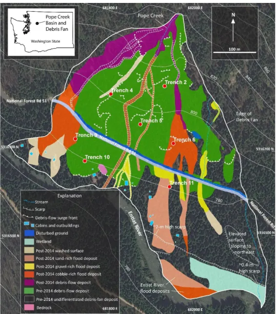
Fig. 1. Map of the Pope Creek debris fan showing surficial geology mapped in 2017, location of trenches excavated in 2017, and location of cabins and outbuildings near the Entiat River. Trenches 1, 3, 7, 8, and 12 were not excavated, and are therefore not shown here. All post-2014 deposits are part of debris-flow event 10 (DFE10). Coordinates of tick marks are UTM, zone 10, meters. Elevation data are from the National Elevation Dataset (NED, USGS, 2018), contour interval is 20 m. Small inset map shows the location of the fan and basin in Washington State.
The Entiat River basin has a long history of destructive wildfires and subsequent floods and debris flows including events in the 1970s (e.g., Perkins et al., 1971; Klock and Helvey, 1976; Woodsmith et al., 2004), 2014 (Duncan Fire, Burned Area Emergency Response, 2014), and 2015 (Wolverine Fire, Burned Area Emergency Response, 2015). After a wildfire in 1970, debris flows in June 1972 destroyed private cabins and killed four people on the Preston Creek fan in the Entiat Valley (Klock and Helvey, 1976). At the Pope Creek fan, there are records from two historical debris-flow events, one on May 19, 1995 (U.S. Bureau of Reclamation, 2009) that was not related to a wildfire, and another following the Duncan Fire which burned in July and August, 2014. The 1995 event deposited boulders and large woody debris at the head of the fan, and finer sediment on lower parts of the fan, including on National Forest Road 51, and near private, seasonally occupied cabins located on the periphery of the fan near the Entiat River. The post-2014 debris-flow event deposited material on the fan in a similar manner to the 1995 event.
The Duncan Fire burned about 65 percent of the Pope Creek basin at moderate to high soil-burn severity (Burned Area Emergency Response, 2014). Prior to the Duncan Fire, a mixed conifer forest blanketed the basin and fan, with ponderosa pine, grand fir, silver fir, and mountain hemlock trees in the basin, and ponderosa pine on the fan. This vegetation regime is classified by the U.S. Forest Service as Pacific Northwest forested, mixed conifer, eastside mesic. For this vegetation regime, the Forest Service Fire Effects Information System gives mean fire return intervals as 200 yrs, 150 yrs, and 40 yrs for stand replacement, mixed, and surface fire-severity classes, respectively (U.S. Forest Service, 2018). There is not a correlation between soil-burn severity and fire-severity classes (e.g., Safford et al., 2007).
3. Methods
During field work in the spring and summer of 2017, we mapped deposits on the surface of the Pope Creek fan, and excavated and mapped seven trenches in the fan. We identified deposits on the fan surface and then mapped deposit boundaries on a June 2016 Digital Globe WorldView-2 image. Trenches were about 6 m long, 2.4 m (8 ft) deep, and had two 1.2 m (4 ft) high walls separated by a 1.2 m (4 ft) wide bench. At each trench, we mapped and described deposits, flagged unit contacts using nails and flagging, surveyed the position (UTM zone 10 coordinates and elevation above mean sea level in m) of all flagged nails using a total station surveying unit, and collected charcoal samples for radiocarbon dating. Charcoal samples were all detrital charcoal, meaning that the charcoal was not created in-situ, but instead was transported to its deposition location from an upstream location either on the fan or in the basin, and thus provided maximum ages for the deposits.
We interpreted deposits as debris-flow deposits or flood (water-dominated) deposits based on sedimentological characteristics. Debris-flow deposits were unsorted, matrix-supported deposits that contained randomly oriented clasts (cobbles and boulders). Flood deposits were sorted, clast supported, contained layers, and were generally finer grained than debris-flow deposits.
From surface and subsurface exposures, we documented that the Pope Creek fan is dominated by debris flows rather than floods, but, we also know from observations of debris-flow events in multiple locations that individual events often have both debris flow and flood components, both in time and in space. Previous investigations have shown that there can be debris flows and/or floods over periods of years to possibly decades that leave sedimentologically identical deposits that cannot be distinguished from one another in cross section unless there are soil horizons visible between the deposits (see Major, 1997 for additional details). To account for such uncertainties, throughout this paper, we use the term debris-flow event (DFE) to describe historical and pre-historic flow events on the fan. A single DFE can include one or more flows that cannot be distinguished from one another, either on the fan surface, or in stratigraphic sections. We identified 10 DFEs at Pope Creek, with the oldest designated as DFE1 and the youngest as DFE10. An individual DFE can contain both debris-flow deposits and flood deposits on different parts of the fan surface, or at single locations. Flows on the fan after the Duncan Fire (Post-2014 DFE10, Fig. 1) are useful to illustrate this point. In DFE10, there were multiple flows following the 2014 Duncan Fire that were indistinguishable from one another on the fan surface and in trenches. Additionally, DFE10 had debris flow and flood components (Fig. 1), with debris-flow deposits near the head of the fan, and flood deposits on the middle and lower parts of the fan.
Soil horizons can be useful to distinguish DFEs because they indicate hiatuses in the debris-flow depositional cycle. For soil descriptions, we used the nomenclature of Schoeneberger et al. (2012). Specifically, we described A, B, and C soil horizons. An A horizon is organic matter and mineral-rich material that accumulates at or near the land surface. A B horizon underlies an A horizon and is different from the original parent material because of an
accumulation of secondary material, color, or structures (aggregation of soil particles). A C horizon is a subsurface horizon and can be like or unlike the material from which the soil formed. C horizons lack properties of A and B horizons. At the Pope Creek fan, C horizons are the parent material from which the A and B horizons formed. In some cases, because of a lack of adequate time and/or climatic conditions, there are C horizons at Pope Creek that never had A and B horizons form. Additionally, it is possible that some C horizons had A and/or B horizons at one point in time that were locally scoured away by subsequent floods and debris flows.
We submitted 17 charcoal samples for accelerator mass spectrometry (AMS, 14C) dating to the Woods Hole
Oceanographic Institute (16 samples) and Beta Analytic, Inc. (1 sample). Prior to submittal, we removed inorganic sediment and any organics from modern plant roots and dried the samples by heating them in an oven at 50°C for 2 hours.
We identified and correlated DFEs (Fig. 2) using soils and radiocarbon dates as constraints. To model the timing of DFEs from radiocarbon dates, we used OxCal radiocarbon calibration and analysis software version 4.3.2 (Bronk Ramsey, 2009, 2017) and the IntCal13 calibration curve of Reimer et al. (2013). OxCal is a Bayesian analysis tool that probabilistically models the timing of undated DFEs by incorporating the time distributions of all available chronological constraints (14C dates from charcoal in our case). Oxcal produces a
probability density function (PDF) for each undated event. We modeled the maximum ages for the deposition of DFEs (i.e., the age of fires that created the charcoal) using OxCal R_Date commands for units with single charcoal samples, OxCal R_Date and Phase commands for units with multiple charcoal samples, and Date commands for ages of the individual DFEs (see Lienkaemper and Bronk Ramsey, 2009, and DuRoss et al., 2011 for additional details regarding these OxCal commands). Our modelling provides mean values and 95% confidence interval bands for the maximum ages of DFEs.
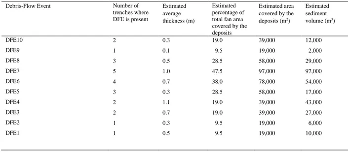
We estimated volumes for each DFE based on our observations of the post-2014 DFE10 event. We used the percentage of the fan area covered by DFE10 (19%) and the number of trenches where deposits from DFE10 were exposed (2) to establish an equation to estimate the sediment volume (V) of DFE10, and the other nine DFEs:
V = MT*TE*PF*TA (1)
where MT is the mean thickness (m) of DFE deposits from map and/or trench exposures, TE is the number of trenches where DFE deposits are exposed, PF is 0.095, which is the estimated percentage (9.5%, 19%/2 based on DFE10) of the fan that is covered for each trench where DFE deposits are exposed, and TA is 204000, which is the total area of the fan (m2). For DFE10 (the post-2014 event), MT was based on about 10 natural exposures as well as
trench exposures. For all pre-2014 DFEs, MT was estimated from trench exposures alone. This approach for calculating DFE volumes relies on an assumed positive correlation between the percentage of fan area covered by a DFE, and the number of trenches where the DFE is exposed. An additional assumption is that all DFEs would have a similar pattern of deposition to that of DFE10. For example, if a pre-2014 DFE primarily transported material down a single channel and into the Entiat River, rather than spreading across the fan in multiple depositional “fingers” as DFE10 did, then our method for estimating volume would underestimate the volume of the event, or we would simply not see the event in our limited number of trenches. The obvious limitation of our methodology is that it yields rough volume estimates that are subject to refinement as additional trench data become available, or if better subsurface mapping methodologies are used at the fan.
4. Results
Our surficial map of the fan (Fig. 1) distinguishes two ages of material: pre-2014 material that is boulder-rich debris-flow deposit, and post-2014 (DFE10) material that was deposited in 2 or 3 separate flows that the U.S. Forest Service documented as occurring between August 2014 and October 2016. DFE10 had both debris-flow and flood deposits and had an estimated sediment volume of 12,000 m3 (Table 1). The pre-2014 material can be
broken into DFEs based on exposures in trenches and from radiocarbon dates (see Fig. 2).
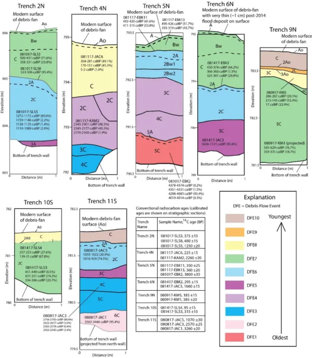
Trench exposures reveal a total of 10 DFEs in the last 4000 years (Fig. 2). The timing of DFEs 10 and 9 are from historical records. The ages of DFEs 8-6 are well constrained both spatially and temporally because of the presence of buried A and B soil horizons, as well as an abundance of radiocarbon dates. The ages and spatial correlations between trenches for DFEs 5-1 are poorly constrained because of a general lack of soils and sparse availability of radiocarbon dates. The average thicknesses of individual DFEs range from 0.1 to 1.1 m (Table 1).
Estimated sediment volumes of DFEs ranged from 2,000 m3 (DFE9) to 97,000 m3 (DFE7, Table 1). We estimate
that the largest DFE in the 4000-year period of record (DFE7) covered about 48% of the total fan area (Table 1). The modelled ages for each DFE are shown in Figure 3. DFEs had a mean recurrence interval of 433 +/- 44 years for the 4000-year period of record. However, over the last 300 years, DFEs seem to be occurring more frequently, with mean recurrence intervals for the last 4 DFEs (DFEs 10-7) ranging from about 260 to 20 years (Fig. 3). We suspect that this observation is an artifact because we have good soil, radiocarbon, and historical constraints for the last several hundred years that allow us to better distinguish DFEs compared to the rest of the period of record. The largest DFE in the period of record, DFE7, occurred about 285 +/-98 cal yr BP (1665 AD).
Fig. 2. One-meter wide sections showing stratigraphy exposed in each trench shown in Figure 1. “N” and “S” in trench names refers to north and south walls, respectively. Correlation of debris-flow events (DFEs) between trenches are shown with colors. Soil designations shown in individual sections refer to A, B, and C soil horizons used to correlate deposits between trenches. Conventional radiocarbon ages are shown in the table and calibrated ages are shown in stratigraphic sections. Correlations of older deposits (DFEs 1-5) were difficult because of poor soil and radiocarbon constraints. These correlations are subject to revision as additional radiocarbon dates become available in the future.
Table 1. Estimated areas and sediment volumes for debris-flow events. Estimates are based on measurements of DFE10 which covered 19% of the total fan area and was exposed in two of the seven trenches. Average thickness of DFE10 was estimated from both surface and subsurface (i.e., trench) mapping. All other average thickness estimates were made from multiple measurements in trenches alone. Total fan area is 204,000 m2. If deposits from a
debris-flow event were exposed in all seven trenches, we estimate that the event would have covered 67% of the fan.
Debris-Flow Event Number of
trenches where DFE is present Estimated average thickness (m) Estimated percentage of total fan area covered by the deposits Estimated area covered by the deposits (m2) Estimated sediment volume (m3) DFE10 2 0.3 19.0 39,000 12,000 DFE9 1 0.1 9.5 19,000 2,000 DFE8 3 0.5 28.5 58,000 29,000 DFE7 5 1.0 47.5 97,000 97,000 DFE6 4 0.7 38.0 78,000 54,000 DFE5 3 0.3 28.5 58,000 17,000 DFE4 2 1.1 19.0 39,000 43,000 DFE3 2 0.7 19.0 39,000 27,000 DFE2 1 0.3 9.5 19,000 6,000 DFE1 1 0.5 9.5 19,000 10,000
By combining the modelled ages (Fig. 3) and estimated volumes (Table 1) for DFEs over the last 4000 years, we defined a magnitude/frequency relation for debris-flow events on the fan (Fig. 4). This relation shows that the annual probability of DFEs exceeding 1000 m3 is about 0.3 percent, whereas the annual probability for events
exceeding 90,000 m3 is about 0.03 percent. This relation is based on the entire period of record and assumes
stationarity in climate over the period of record. Stationarity is the concept that climate and other natural systems fluctuate within an unchanging envelope of variability (e.g., see Milly et al., 2008 for details). Climate change is altering the range of historical climate variability (i.e., temperatures and precipitation) and is expected to render the stationarity assumption invalid (Milly et al., 2008). Our magnitude/frequency relation (Fig. 4) does not account for a change in climate stationarity that could be related to the observed increase in DFE frequency over the last several hundred years.
5. Discussion
Wildfires increase the susceptibility of hillslopes to debris flows (e.g., Cannon and Gartner, 2005), but meteorological events trigger the flows. Based on the prevalence of charcoal in our trenches, wildfires have repeatedly burned the Pope Creek basin during the last 4000 years. For the vegetation assemblage that existed at Pope Creek prior to the Duncan Fire, the estimated mean return period for surface fires and stand replacement fires are 40 and 200 years, respectively (U.S. Forest Service, 2018). The surface fire interval is about an order of magnitude less than our mean debris-flow recurrence interval (433 years), whereas the stand replacement interval is about half of our debris-flow interval. In addition to the post-Duncan fire DFE (DFE10), past fires have undoubtedly contributed to other DFEs at Pope Creek. However, the resolution of our data does not allow us to establish a direct link between the timing of fires and debris flows at Pope Creek.
Our records of climatic variations in the Holocene that could influence the magnitude and frequency of fires and meteorological events are similarly crude. Available climate data for our 4000-year period of record come from two sources, radiocarbon-dated pollen records from multiple sites in Washington State (e.g., Whitlock, 1992), and historical records of world-wide climate anomalies such as the Medieval Warm Period and the Little Ice Age (e.g., Broecker, 2001). Pollen records reveal broad changes in temperature and precipitation during the Holocene. In general, these records (e.g., Prichard et al, 2009; Mack et al., 1979) indicate a shift from warm dry conditions in the mid Holocene (~8000 to ~4500 cal yr BP) to cool moist conditions in the late Holocene (~4500 cal yr BP to Present). All of our DFEs occurred in this cooler, moister time period. The Medieval Warm Period
and the Little Ice Age are warmer and cooler periods that are overprinted on this overall period of cool moist conditions.
The largest debris-flow event in our record (DFE7, Table 1) occurred during the Little Ice Age and the 2nd largest
event (DFE6, Table 1) occurred at the end of the Medieval Warm Period or in the transition period between the Medieval Warm period and the Little Ice Age (Figure 3). The significance of the largest event occurring during the Little Ice Age is unclear. However, there is about an 8x difference in size between DFE7 and the size of the event that we know is related to wildfire (DFE10). If we speculate a little, this difference may indicate that the largest DFE was triggered by an exceptional meteorological event that occurred during a cool wet time period, and that smaller DFEs were triggered by less exceptional meteorological events that occurred closely following wildfires.
.
Fig. 3. Probability (PDFs) for the time of debris-flow events (DFEs) on the fan. Fig. 4. Annual probability of exceedance for debris- BP is “Before Present” with “Present” (0 on the x -axis) defined as 1950 AD. PDFs flow event volumes on the Pope Creek fan derived were modeled using the Date command in OxCal. Mean values are shown as small from data in Table 1 using the Poisson probability black circles. Horizontal bars under each PDF show 2σ ranges. Recurrence intervals model and methods described in Coe et al. (2004). between DFEs are the time periods between mean values. Times of the Medieval
Warm Period (1150-750 cal yr BP, 800-1200 AD) and Little Ice Age (600-90 cal yr BP, 1350-1860 AD) are from Broecker (2001).
6. Conclusions
We mapped and trenched a small flow fan in central Washington State and found evidence of 10 debris-flow events in the last 4000 years. We used radiocarbon dates from trenches in the program OxCal to model the ages and recurrence intervals between debris-flow events. The mean recurrence interval is 433 years, but intervals range from 724 to 20 years. The four most recent events have the shortest recurrence intervals. The largest event, with an estimated sediment volume of 97,000 m3, occurred at about 285 cal yr BP (1665 AD) during the Little Ice Age. The
most recent debris-flow event that was triggered by rainstorms following a wildfire in 2014 was about 8x smaller than the largest event. These results may indicate that the post-fire debris-flow event was triggered by a rainstorm with a relatively small (short) return period compared to the meteorological event that triggered the largest debris flow.
Acknowledgements
We thank the U.S. Forest Service for granting permission for our work at the Pope Creek fan; Jay and Diane Batchelor of Batchelor Excavation for their professional excavation of the trenches; Chris DuRoss and Alan Nelson
for providing expert advice regarding the use of OxCal; and Kate Scharer, Alex Densmore, and Dennis Staley for their constructive reviews. Any use of trade, firm, or product names is for descriptive purposes only and does not imply endorsement by the U.S. Government.
References
Balbas, A.M., Barth, A.M., Clark, P.U., Clark, J., Caffee, M., O’Connor, J., Baker, V.R., Konrad, K., and Bjornstad, B., 2017, 10Be dating of late Pleistocene megafloods and Cordilleran Ice Sheet retreat in the northwestern United States: Geology, v. 45, no. 7, p. 583-586.
Broecker, W.S., 2001, Was the Medieval Warm Period global?: Science, v. 291, no. 5508, p. 1497-1499. doi: 10.1126/science.291.5508.1497 Bronk Ramsey, C., 2009, Bayesian analysis of radiocarbon dates: Radiocarbon, v. 51, no. 1, p. 337-360.
Bronk Ramsey, C., 2017, Methods for Summarizing Radiocarbon Datasets: Radiocarbon, 59(2), p. 1809-1833. Burned Area Emergency Response, 2014, BAER analysis summary: Duncan Fire 09/08/2014, 11 p.
Burned Area Emergency Response, 2015, BAER analysis briefing: Wolverine Fire 2015, 4 p.
Cannon, S.H. and Gartner, J.E., 2005, Wildfire-related debris flow from a hazards perspective: Chapter 15 in: Jakob, M. and Hungr, O. eds., Debris flow hazards and related phenomena: Praxis, Springer, Berlin, Heidelberg, p. 363–385.
Coe, J.A., Michael, J.A., Crovelli, R.A., Savage, W.Z., Laprade, W.T., Nashem, W.D., 2004, Probabilistic assessment of precipitation-triggered landslides using historical records of landslide occurrence, Seattle, Washington: Environmental & Engineering Geoscience, v. 10, p. 103-122.
DuRoss, C.B., Personius, S.F., Crone, A.J., Olig, S.S., and Lund, W.R., 2011, Integration of paleoseismic data from multiple sites to develop an objective earthquake chronology: Application to the Weber segment of the Wasatch Fault Zone, Utah: Bulletin of the Seismological Society of America, v. 101, no. 6, p. 2765-2781.
Frechette, J.D. and Meyer, G.A., 2009, Holocene fire-related alluvial-fan deposition and climate in ponderosa pine and mixed conifer forests, Sacramento Mountains, New Mexico, USA: The Holocene, v. 19, no. 4, p. 639-651.
Haugerud, R. A., and Tabor, R. W., 2009, Geologic map of the North Cascade Range, Washington: U.S. Geological Survey Scientific Investigations Map 2940, 2 sheets, scale 1:200,000; 2 pamphlets, 29 p. and 23 p.
Klock, G.O. and Helvey, J.D., 1976, Debris flows following wildfire in north central Washington: Proceedings of the Third Interagency Sedimentation Conference, Denver, CO, pp. 9.
Lienkaemper, J.L. and Bronk Ramsey, C., 2009, OxCal: versatile tool for developing paleoearthquake chronologies- a primer: Seismological Research Letters, v. 80, no. 3, p. 431-434. doi:10.1785/gssrl.80.3.431
Mack, R.N., Rutter, N.W., Valastro, S., 1979, Holocene vegetation history of the Okanogan Valley, Washington: Quaternary Research, v. 12, no. 2, p. 212-225.
Major, J.J., 1997, Depositional processes in large-scale debris-flow experiments: The Journal of Geology, v. 105, p. 345-366.
Milly, P.C.D., Betancourt, J., Falkenmark, M., Hirsch, R.M., Z.W. Kundzewicz, Lettenmaier, D.P., & Stouffer, R.J. 2008, Stationarity is Dead: Whither Water Management?: Science, v. 319, p. 573-574.
Perkins, R.F., Woodard, R.A., and Ryan, T.P., 1971, Operational report of rehabilitation of the north central Washington fires: Wenatchee National Forest report, U.S. Department of Agriculture, 33 p.
Pierce, J. and Meyer, G., 2008, Long-term fire history from alluvial fan sediments: the role of drought and climate variability, and implications for management of Rocky Mountain forests: International Journal of Wildland Fire, v. 17, p. 84-95.
Porter, S.P., 1978, Glacier Peak tephra in the north Cascade Range, Washington: stratigraphy, distribution, and relationship to late-glacial events: Quaternary Research, v. 10, p. 30-41.
Prichard, S.J., Gedalof, Z., Oswald, W.W., and Peterson, D.L., 2009, Holocene fire and vegetation dynamics in a montane forest, North Cascade Range, Washington, USA: Quaternary Research, v. 72, p. 57-67.
Reimer, P. J., Bard, E., Bayliss, A., Beck, J. W., Blackwell, P. G., Bronk Ramsey, C., Grootes, P. M., Guilderson, T. P., Haflidason, H., Hajdas, I., Hatté, C., Heaton, T. J., Hoffmann, D. L., Hogg, A. G., Hughen, K. A., Kaiser, K. F., Kromer, B., Manning, S. W., Niu, M., Reimer, R. W., Richards, D. A., Scott, E. M., Southon, J. R., Staff, R. A., Turney, C. S. M., and van der Plicht, J., 2013, IntCal13 and Marine13 Radiocarbon Age Calibration Curves 0-50,000 Years cal BP: Radiocarbon, v. 55, no. 4, p. 1869-1887.
Safford, H.D., Miller, J., Schmidt, D., Roath, B., Parsons, A., 2007, BAER soil burn severity maps do not measure fire effects to vegetation: a comment on Odion and Hanson (2006): Ecosystems, v. 11, no. 1, p. 1-11. doi: 10.1007/s10021-007-9094-z
Schoeneberger, P.J., Wysocki, D.A., Benham, E.C., and Soil Survey Staff, 2012, Field book for describing and sampling soils, Version 3.0: Natural Resources Conservation Service, National Soil Survey Center, Lincoln, Nebraska.
Tabor, R.W., Frizzell, V.A., Jr., Whetten, J.T., Waitt, R.B., Swanson, D.A., Byerly, G.R., Booth, D.B., Hetherington, M.J., Zartman, R.E., 1987, Geologic map of the Chelan 30-minute by 60-minute quadrangle, Washington: U.S. Geological Survey Miscellaneous Investigation Series Map I-1661, scale 1:100,000.
U.S. Bureau of Reclamation, 2009, Entiat tributary assessment, Chelan County, Washington: U.S. Bureau of Reclamation Technical Services Section, Denver, CO, 92 p., 8 appendices. https://www.usbr.gov/pn/fcrps/ce/wash/entiat/tribassmt/entiattribassmt.pdf, last accessed October 2018.
U.S. Forest Service, 2018, Fire regimes of the conterminous United States: U.S. Forest Service Fire Effects Information System (FEIS) web site, https://www.fs.fed.us/database/feis/fire_regime_table/PNVG_fire_regime_table.html#NorthwestForested, last accessed October 2018. U.S. Geological Survey, 2018, National Elevation Dataset (NED): http://nationalmap.gov/elevation.html, last accessed September 2018. Whitlock, C., 1992, Vegetational and climatic history of the Pacific Northwest during the last 20,000 years: implications for understanding
present-day biodiversity: The Northwest Environmental Journal, v. 8, p. 5-28.
Woodsmith, R.D., Vache, K.B., McDonnell, J.J., and Helvey, J.D., 2004, Entiat Experimental Forest: catchment-scale runoff data before and after a 1970 wildfire: Water Resources Research, v. 40, W11701, doi:10.1029/2004WR003296.