Small-Scale Farmers Land Use and Socioeconomic Situation in the Mount Elgon District in Northwestern Kenya : A Minor Field Study - Combined Field Mapping and Interview
69
0
0
Full text
(2) Abstract This Minor Field Study was carried out during November and December in 2011 in the Mount Elgon District in Western Kenya. The objective was to examine nine small-scale farming household´s land use and socioeconomic situation when they have joined a nongovernmental organization (NGO) project, which specifically targets small-scale farming households to improve land use system and socioeconomic situation by the extension of soil and water conservation measures. The survey has worked along three integral examinations methods which are mapping and processing data using GIS, semi structured interviews and literature studies. This study has adopted a theoretical approach referred to as political ecology, in which landesque capital is a central concept. The result shows that all farmers, except one, have issues with land degradation. However, the extent of the problem and also implemented sustainable soil and water conservation measures were diverse among the farmers. The main causes of this can both be linked to how the farmers themselves utilized their farmland and how impacts from the climate change have modified the terms of the farmers working conditions. These factors have consequently resulted in impacts on the informants’ socioeconomic conditions. Furthermore it was also registered that social and economic elements, in some cases, were the causes of how the farmers manage their farmland. The farmer who had no significant problem with soil erosion had invested in trees and opportunities to irrigate the farmland. In addition, it was also recorded that certain farmers had invested in particular soil and water conservation measures without any significant result. This was probably due to the time span these land measures cover before they start to generate revenue. The outcome of this study has traced how global, national and local elements exist in a context when it comes to the conditions of the farmers´ land use and their socioeconomic situation. The farmers at Mt. Elgon are thereby a component of a wider context when they are both contributory to their socioeconomic situation, mainly due to their land management, and also exposed to core-periphery relationships on which the farmers themselves have no influence. Keywords: land use, small-scale farmer, socioeconomic situation, sustainable soil and water conservation measures, GIS, semi-structured interviews, political ecology, landesque capital, land degradation, core-periphery relationships.
(3) Table of Contents 1. Introduction ......................................................................................................................................... 1 1.1 Aim................................................................................................................................................. 1 1.2 Investigated questions .................................................................................................................. 1 1.3 Outline ........................................................................................................................................... 2 1.4 Explanation of terms ..................................................................................................................... 2 2. Methodology ....................................................................................................................................... 3 2.1 Field methodology ......................................................................................................................... 3 2.1.1 Examinations methods ........................................................................................................... 3 2.1.2 Working procedure ................................................................................................................ 4 2.1.3 Limitation................................................................................................................................ 4 2.1.4 Ethical considerations............................................................................................................. 4 2.2 Criticism of the sources ................................................................................................................. 4 3. Kenya ................................................................................................................................................... 6 3.1 Physico-geographical conditions ................................................................................................... 6 3.1.1 Topography and vegetation ................................................................................................... 6 3. 1.2 Climate................................................................................................................................... 6 3.2 Socioeconomic situation and Land use system ............................................................................. 6 4. Climate change .................................................................................................................................... 8 4.1 Global climate change ................................................................................................................... 8 4.2 A global response to the impacts from climate change ................................................................ 9 4.3 Climate change and impacts in Kenya ......................................................................................... 10 5. Political ecology ................................................................................................................................. 10 5.1 The theory ................................................................................................................................... 10 5.2 Land degradation......................................................................................................................... 12 5.2.1 Soil erosion forces on land degradation ............................................................................... 12 5.2.2 Course of event of related erosions process ........................................................................ 13 5.3 Landesque capital ........................................................................................................................ 13.
(4) 5.3.1 Examples of landesque capital investments ........................................................................ 13 6. Project and Survey area..................................................................................................................... 15 6.1VI Agroforestry Programme (VI AFP)............................................................................................ 15 6.2 Cooperation between VI Agroforestry Programme (VI AFP) and Dalarna University (HDa) ...... 15 6.3 Survey area .................................................................................................................................. 15 6.4 Mount Elgon Integrated Watershed Management Project ........................................................ 16 7. Result ................................................................................................................................................. 18 7.1 Farm 1 - Kapsokwony .................................................................................................................. 18 7.2 Farm 2 – Kapsokwony.................................................................................................................. 19 7.3 Farm 3 – Cheptais ........................................................................................................................ 21 7.4 Farm 4 – Kopsiro.......................................................................................................................... 23 7.5 Farm 5 – Kopsiro.......................................................................................................................... 24 7.6 Farm 6 – Cheptais ........................................................................................................................ 26 7.7 Farm 7 – Cheptais ........................................................................................................................ 28 7.8 Farm 8 – Kopsiro.......................................................................................................................... 30 7.9 Farm 9 - Kopsiro .......................................................................................................................... 31 8. Analysis .............................................................................................................................................. 34 8.1 General characteristics of the farmers´ land use ........................................................................ 34 8.2 General characteristics of the farmers´ socioeconomic situation .............................................. 35 8.3 General characteristics of the farmers´ experience of land degradation and effects from climate change ............................................................................................................................................... 35 8.4 General characteristics of the farmers’ expectations with the NGO project .............................. 37 8.5 Results linked to the literary sources .......................................................................................... 37 9. Discussion .......................................................................................................................................... 40 10. Conclusion ....................................................................................................................................... 42 11. Proposals for future studies ............................................................................................................ 43 12. References ....................................................................................................................................... 44 12.1 Published ................................................................................................................................... 44.
(5) 12.2 Articles ....................................................................................................................................... 44 12.3 Reports ...................................................................................................................................... 45 12.4 Unpublished sources ................................................................................................................. 45 12.5 Internet ...................................................................................................................................... 45 12.6 Oral sources ............................................................................................................................... 46 12.7 Figurers ...................................................................................................................................... 46 13. Appendices ...................................................................................................................................... 46 13.1 Maps .......................................................................................................................................... 46 13.2 Questionnaire ............................................................................................................................ 56.
(6) 1. Introduction Land use is about how man utilizes the land. Depending on how investments are implemented it can provide various utilities. Furthermore unsustainable land management through overexploitation of natural resources can entail to decline in the soil potential productivity, which subsequently can lead to impacts on living conditions. The effects from a changing climate can also set the terms in how soil properties can be utilized by the land users. In Kenya subsistence agriculture and firewood are the main energy sources among the population, especially in rural areas. But elements such as a high population pressure on natural resources, unsustainable land management and a changing climate has put several areas in Kenya under severe press. These circumstances have thus modified the work conditions for especially small-scale farmers when it has accelerated the problem with land degradation, in which productivity decline is a noticeable part. Because of these emphasized factors the World Bank in association with the NGO organization: VI Agroforestry Programme have launched a project in the Mt. Elgon district in Western Kenya. The primary objective with the project is to improve the living condition in the area by generating inventive among the small-scale farmers to execute particular sustainable land use system. This amplified soil and water conservation measure on the farmers’ agriculture land and also decreased pressure on natural resources in the project area. To investigate which conditions that distinguish and influence the small-scale farmers’ social and economic situation and land management nine interviews and maps have been conducted in the project area.. 1.1 Aim This survey aims at investigating small-scale farming households´ land use and socioeconomic situation in the Mt Elgon district, Western Kenya. The farmers have recently joined a non-governmental organization (NGO) project, specifically targeting small-scale farming households to improve land use system and socioeconomic situation by extension of agroforestry practices and soil and water conservation measures. This will be carried out by interviewing the farmers and mapping their farmland. This study will be a “zero-position” survey that has the possibility for a follow-up study in about 3-5 years.. 1.2 Investigated questions The survey will be based on the following questions: -. What characterizes land use in the study area? How is the socioeconomic situation among small-scale farming households at present? Have the farmers experienced any problems with land degradation and effects of climate change, and if so, how are the problems expressed? How do the farmers look upon the future and what are their expectations on the NGO project?. 1.
(7) 1.3 Outline The thesis begins with aim, question formulations and definition of particular concepts. Then follows the section Method and material that, for example, reports, examinations methods, working procedure and criticism of the sources. This will be followed up by the chapter Background which, among other things, describes information about the VI Agroforestry Programme (VI AFP) activities and the general landscape and social and economic elements in Kenya. Then follows the chapter Theory that treats the theoretical approach of the survey. The chapter Result will report the data collected from each field survey separately, which is followed by an Analysis where the results among the informants and how it is related to the theoretical approach are analyzed. The thesis concludes with Discussion and Conclusion, in which relevant aspects from previous chapters and suggested further research are discussed. Additionally the chapter Reference will present used sources in the thesis while Appendices will contain designed maps and questionnaire.. 1.4 Explanation of terms Agroforestry Agroforestry is a land use system that combines crops and/or livestock together with trees/scrubs within same land management unit (Markensten, 1993, p. 23). Food security The term refers to sufficient food that subsequently can lead to an active and healthy life for all people at all times (Odingo, 2010, p. 2). Poverty In this thesis the term is defined as the situation of life that is lower than reasonable definition of decency of human life, in which malnutrition, diseases, illiteracy are central elements (Odingo, 2010, p. 2). Sustainable development Sustainable development is a concept that aims to present social development which does not compromise the needs and aspirations of future generations´ (Daniels, et al, 2008, p. 474).. 2.
(8) 2. Methodology 2.1 Field methodology This survey was, together with VI AFP, conducted around Mt. Elgon in the Western Province of Kenya between November and December 2011. The field work emanated from VI AFP head office in Kitale to visit the survey farms which all were located adjacent to Mt. Elgon. The selection of informants in the survey was determined in dialogue with the staff of VI AFP. 2.1.1 Examinations methods This thesis has been conducted along three integral examinations methods. These are mapping and processing data using GIS, semi structure interviews and literature studies. Mapping and processing data using GIS GIS-technology (Geographical Information System), along with an iPhone and the programs ArcCatolog, ArcMap 9.2 and iGIS, were used to map the farmers land use. The study´s working procedure with this methodology can be divided into tree central steps; The first procedure is to create shapefiles of points, polyline and polygon in the ArcCatalog. Then each shapefile is transferred to ArcMap 9.2 to attach a text file where the user later can type information during the field mapping. Before the transfer to iPhone and its program iGIS the shapefiles must be compressed into one file. In iGIS the projection must be set to start the coordinate set of points, polyline and polygon. The second step is collecting data from the field by mapping points, line and polygons. The third stage is to transfer this data to a PC and ArcMap for adapting, analyzing and presenting the maps. Semi structured interviews Interviews were conducted with the farmers in the Mt. Elgon district. The main purpose to combine the mapping with interviews is to generate deeper knowledge about the farmer´s land use and socioeconomic situation than what the map solely displays. The questionnaire that was used during all interviews was semi structured with both open ended and closed ended questions. The objective with the questionnaire was to obtain descriptions of the interviewee’s aspects on their world and interpret the meaning of these descriptions (Brinkmann & Kvale, 2009). In order to protect the respondent´s privacy fictitious name have been used in the thesis. In addition, to decrease the risk for outsiders to identify the farmers land no sublocation will be present. Only which division within the Mt. Elgon district where the farmland is located is presented in the result. An English interpreter of Swahili was needed during all interviews except one. The interview where an interpreter was not used was due to the informants’ good English. Besides that the notes from the interviews and the coordinates of the respective farm location are kept by the researcher. Literature studies The collected data from the field interviews and mapping is complemented by previously published scientific articles and books which are relevant to the subject. The main reason for 3.
(9) applying previous scientific literature as a complement to the collected material is to secure the scientific quality of this study. 2.1.2 Working procedure This study can primarily be divided into six works steps. The first step was to set out the purpose and questions with the survey. The second step was to collect material through literature and internet searches and to construct the questionnaire and prepare the mapping. The third step was to conduct the interviews and mapping. Later the fourth and five steps were to critically evaluate the collected material and analyze this through construction of maps and text. The final step was then to present and discuss the survey’s findings. 2.1.3 Limitation Regarding the mapping of the farmers´ land use generalizations have been executed, which is inevitable in mapping. A map is always a generalization of the reality to make it legible to the reader. A concrete example of this was the mapping of some tree lines and areas. The examiner did not have the ability to map each tree within some areas or lines. Due to this the examiner used shapefiles of lines or polygon to generalize these. However the distance, area and approximate number of trees where delineated during this type of mapping. The last question in this study will not be set in relation to any theory. The reason to this is to produce a baseline of the farmers´ expectations with the NGO-project which then can be evaluated by follow-up studies. In the chapter Result, the scale of the attached maps can, to some degree, be incorrect. This because the size of the attached map has been adjusted to fit the text in this chapter. Due to the fact that the scale information is a core requirement in maps the scale information cannot be removed from the designed maps in the result. The correct scale of the designed maps is however correct in the chapter Appendices. 2.1.4 Ethical considerations To protect the informants´ integrity before, during and after the survey four main ethical requirements have been implemented. These requirements are defined by the Swedish Research Council within Humanities and social sciences. These ethic principles are referred to as follows; (I) Information requirement: All informants were informed, before respective interview, about the purpose of the survey, their task in the study and their conditions for participating. (II) Consent requirement: All informants received information that their involvement was voluntary and they had the right to cancel their participation during the interview. (III) Confidentiality requirement: All data from the fields studies have been treated with highest confidentiality. An example of this is the use of fictitious names that accordingly has reduced the risk that outsiders can identify the informants. Moreover, no one, except the researcher and VI AFP, can identify the farms´ location when no sublocation is presented (IV) Utilization requirement: The data from the field study has only been used for scientific purposes which means that it has not been used for commercial use or other nonscientific purposes (vr.se, forskningsetiska principer, 2011-10-12).. 2.2 Criticism of the sources To confirm the study´s scientific quality considerations about validity (relevance) and reliability (trustworthiness) against the collected data materials and the analysis of these have been established (Brinkmann & Kvale, 2009, p. 264-265). 4.
(10) Validity is used as a tool to ensure that the objective with the survey’s purpose has been executed. The validity of this study can be considered high since the data collection and analysis of these have been performed on an approach that is relevant for the study context. An example of this is that the pattern of the questionnaire is semi structured that subsequently has allowed the informants to spontaneously describe their situation within the study framework. Furthermore the collected data have been set towards a theory approach, which consequently can have enlarged both the levels of validity and reliability. The reliability is about whether the data collection and analysis of this has been executed in an objective approach, in the sense that the researcher has reflected on his own contribution to the production of knowledge to the survey topic (Brinkmann & Kvale, 2009, p. 264-265). The reliability can be considered to be high as the informants were explicitly informed, before respective interview, about the confidentiality and utilization requirement with the collected data from interviews and mapping. This factor thus gave the informants the opportunity to answer the questions honestly. One factor that can reduce the reliability is the use of an interpreter during the interviews is due to the interviewer’s lack in the indigenous language, Swahili. This factor can therefore result in a loss of information during the interviews with the farmers. The interpreters were tied to the VI AFP. This can entail a conflict of interest among the organization and the researchers’ objective with the survey. However, the risk that some interpreters may have interpreted the informants´ answers incorrectly can be considered very low in nine of ten conducted interviews. The interview where the interpreter can have corrected the informant´s answers were, with the map, excluded from the thesis. All interpreters were explicitly informed that the objective with the survey was to conduct a baseline of the farmers´ land use and socioeconomic conditions, which consequently has the ability to be followed by another study to evaluate the development of these elements. This factor has most likely reduced the risk that interpreters have corrected the informants´ answer. But for a planned follow-up study it is recommended to employ interpreters that are not linked to VI AFP when this research has the ability to examine the result in how the implemented soil and water conservation measure has evolved. This element can therefore increase the risk for conflict of interest between the examiner and staff from VI AFP if the interpreters are connected to this organization. One factor that has increased the reliability of the collected data is that the farmer and an employee from VI AFP participate in each mapping chiefly to clarify which type of crops or tree that were mapped.. 5.
(11) 3. Kenya 3.1 Physico-geographical conditions 3.1.1 Topography and vegetation Kenya consists of a land surface of 580 000 km2 and is located at the equator in eastern Africa. Kenya borders to Tanzania in the south, Uganda in the west, Sudan and Ethiopia in the north, Somalia in the northeast and the Indian Ocean in the southeast (NE, Kenya, 201110-11). The landscape topography in Kenya is characterized by a complex structure with significant contrasts. A coastline is located in the southeast along the Indian Ocean. From the lowland coast areas towards the central parts of Kenya the land rises gradually to a high plateau in the central and western parts of Kenya. The highlands represent one quarter of Kenya’s land mass. In the central of Kenya Mt. Kenya is located (5200 m.a.s.l). This area is bisected by The Great Rift Valley, which consists of a system of graben, faulting and horst. In the west the central high plateau flattens out to the Lake Victoria Basin. The areas at the Lake Victoria Basin are hillocky which, among other things, consist of some tropical rainforests. North of Lake Victoria Basin near to the Uganda border the extinct volcano Mt. Elgon (4321 m.a.s.l) is located (NE, Kenya, 2011-10-11). The land mass in Kenya consists of approximately 83 percent of semi-arid and arid landscape (Ekbom et al, 2001, p.435.). The remaining 17 percent of the land mass consists of arable land. However, only seven percent of the arable land can be described as highly productive for farming (Ekbom, et al, 2001, p.435). 3. 1.2 Climate Because of the contrasts in the topography conditions it also affect the climate condition, both in terms of average temperature and precipitation. Two main elements affecting the climate, monsoon winds from the Indian Ocean and the diverse altitude levels in the country. The precipitation is unevenly distributed over Kenya, both in terms of geographic location and season. During the year there are usually two rainy seasons over most part of the country. Over large parts of the country there are usually two rainy seasons during the year. These rainy seasons are known as the “long rain” and the “short rain”, as these usually take place during October-December and March-May. As previously emphasized, the precipitation is unevenly distributed over Kenya and northern Kenya is drier than the southern areas (NE, Kenya, 2011-10-11). 3.2 Socioeconomic situation and Land use system The population of Kenya consists of approximately 38 million inhabitants. The population density is 66 inhabitants per square kilometer. However, the population is unevenly distributed over the country. Approximately 75 percent of the population is located on the highlands which consist of 25 percent of Kenya’s total land mass. In year of 2008, Kenya had a natural population growth at 2,8 percent a year. Average life expectancy for both men and women was 53 years (NE, Kenya, 2011-09-15). The population is composed of a variety of different ethnic groups. There are more than 60 different ethnic groups in Kenya. Kikuyu, Luhya and Luo are the largest. Kenya is a. 6.
(12) multilingual country, Swahili and English are the two official languages (NE, Kenya, 201109-15). Regarding the business world agriculture is the main occupation in Kenya, where over half of the production consists of subsistence farming. The most common crops are; sugar, corn, wheat, pyrethrum, sisal and cotton. Additionally the tea cultivation in Western Kenya is an important export product. Moreover the manufacturing and service sectors are important components within the Kenyan employment (NE, Kenya, 2011-09-15). A central element in the Kenyan land use has long been, and still is, activities related to agricultural practices. What generally characterizes the farming’s structural change is a transit from shifting cultivation to permanent cultivation. This applies both to annual and perennial cultivation of food and cash crops. The shifting cultivation was occurring between the thirties and the sixties in Kenya. The vital objective with this land use system was to maintain good fertility in the soil by letting the farmlands alternately lie in fallow to counteract leaching of essential nutrients from the soil. The shifting cultivation rarely resulted in problems with the soil fertility. In addition, no wider uses of chemical fertilizers were used during this period of time (Ovuka, 2000, p. 207). An accelerating amount of agricultural land has been utilized since Kenya’s independence in 1963. This is both a result from the time the British colonial government removed racial barriers for land ownership and that the population has increased in Kenya (Odingo, 2010, p. 4-5). Especially larger areas of hillsides with mountain forest were cultivated. The shifting cultivation system was thus significantly reduced or even disappeared due to the increased competition over potential agriculture land (Ovuka, 2000, p. 205-207). Another factor that has played a considerable role in the extensive deforestation is that trees are a vital fuel and timber source in Kenya. Firewood is essential for the Kenyan production process, especially for the rural population but also for a large part of the urban population (Government of the Republic of Kenya, 1997, p.72). In the 1960s, Kenya’s land mass consisted of about twelve percent forest. Today, its land mass consists of approximately two to three percent of forest (Kenya Government, 2010, p. 11 & NE, Kenya, 2011-09-19). A research about farmers´ perception on the subject of soil changes in two areas in Kenya between 1950 to 1990s registered that the majority of respondents experienced problems with the introduction of chemical fertilizers in their agricultural fields. Most farmers had experienced a decline of the soils natural fertility due to the implementation of chemical fertilizers. To overcome the issue the farmers add more chemical fertilizers in the soil to achieve as high output as they did before the implementation of these fertilizers. Moreover it was solely one farmer out of 40 farmers who believed that fertility had increased since the 1950s. This farmer applied ecological farming techniques without any application of chemical fertilizers (Ovuka, 2000, p. 207). Three quarters of the population are located on the highlands, which represent 25 percent of Kenya´s land mass. The main reason for this is due to the high cultivation potential of the highlands. However the increasing population density has led to extensive deforestation and overgrazing on the steep slopes around the highlands (Government of the Republic of Kenya, 1997, p. 54-55). In addition, the overgrazing has resulted in a decline of livestock numbers, especially among the poor in Kenya (Smucker & Wisner, 2008, p. 206). The accelerating cultivation has been continued for a long time in the highlands and no extensive implementation of soil and water conservations measure have been executed (Gachene et al, 1997, p. 475). This circumstance has therefore resulted in land degradation in several of these areas in the highlands (Government of the Republic of Kenya, 1997, p. 54-55). 7.
(13) During the early 1970s it was established in a report to the UN that Kenya had significant environmental problems, especially with land degradation (Markensten, 1993, p. 23). One main cause of this was accordingly the absence of sustainable land management, which, among other things had intensified the leaching of essential topsoil that thereby reduced or eradicated the soil potential for crop productivity (Government of the Republic of Kenya, 1997, p. 54-55). However the implementations of soil and water conservation measures have been hampered. Especially by political instability, in which major corruption was and still is a problem within the Kenyan social strata. The widespread corruption in the country has resulted to, for instance, that aid agencies and the International Monetary Found (IMF) stopped payments to the country during the 1990s (NE, Kenya, 2011-09-17). Another factor that has worked against political stability in the country is the ethnic fragmentation in the country, which particularly is caused by the political system (Ekbom, et al, 2001, p. 436). Ethnic tensions were particularly evident in the general elections that took place in 2007 when Mwai Kibaki was declared president on dubious grounds, which generated clashes in several areas in Kenya. These contradictions had explicit features of ethnic cleansing. Official numbers report that over 1500 people were killed and over 600 000 people were displaced from their homes during the clashes (NE, Kenya, 2011-09-17). Thus, the factors that have influence on the land management for especially small-scale farmers can be addressed from six macro-level changes. These are (I) population growth, (II) environmental change, (III) increased conflict of natural resources (IV) changes in access of land, (V) changing market condition and availability of services, (VI) political decentralisation in Kenya (Smucker & Wisner 2008, p. 205).. 4. Climate change Climate change refers to conditions as precipitation, temperature and wind that varies over time and space. The earth’s climate is driven from both external and internal factors. External factors are conditions taking place outside the earth as variations in solar radiation, while internal factors are climate conditions that take place on Earth. In addition the internal factors can be caused by both natural and anthropogenic elements. Due to external and internal factors climate fluctuations have constantly existed on the Earth. Moreover the historical causes of these have, in some cases, been raised in speculation. However it has been determined that anthropogenic driving forces have influence on Earth’s climate conditions, especially since the period beginning with industrialization (Bogren, et al, 2006, p. 27, 81). To study the climate change conditions that affect Kenya it is essential to consider both global and national elements.. 4.1 Global climate change IPCC (Intergovernmental Panel on Climate Change) is a scientific intergovernmental body established by the United Nations Environments Programme (UNEP) and World Meteorological Organization (WMO). The IPCC objective is to synthesise worldwide scientific data and thence provide assessments on the current climate change and its potential environmental and socioeconomic impacts (IPCC, 2007, p. 26). The IPCC last report from 2007 registers, undoubtedly, that the climate has become warmer, both concerning sea and land temperature. Consequences of this are numerous, for example, the widespread ice cover has significantly been reduced, which also has brought sea level rises. Since 1850 instrumental measurements of the ground surface have registered that the years between 1995 and 2006 was the warmest period since the measurements were launched. 8.
(14) The increased temperature is distributed over the entire Earth, however, the rise is highest in the northern hemisphere. What also characterizes the global climate changes in the last 50 years is that some weather events have shifted in frequency and/or intensity. For example, cold days and nights are less frequent, while hot days and nights are becoming more frequent. Additionally heat waves have occurred more frequently. Concerning the precipitation this has increased significantly particularly in eastern North and South America and northern Europe. But the precipitation has declined in some areas, such as: parts of Africa and around the Mediterranean regions. Furthermore heavy rains have increased in frequency over most land areas (IPCC, 2007, p. 8). IPCC registers that there are both natural and anthropogenic causes to the climate change. However, the report emphasized that the anthropogenic driving forces have intensified in the last century (IPCC, 2007, p. 8). Examples of these anthropogenic factors – which nevertheless also can occur through natural processes – are (I) Increased emission of greenhouse gases, in which burning of fossil fuels from for example industry and gasoline vehicles are major contributing factors. (II) Change of soil condition such as logging to expand urban settlement results in changes of albedo. This factor can consequently lead to warmer and drier climate when the trees, among other things, give rise to a cooling evaporation and their potential for carbon dioxide sequestration. (III) The continuous increase of aerosols in the atmosphere which primarily affects the radiation balance, especially when concerning a regional level (Bogren, et al, 2006, p. 130, 152-154). IPPC states that impacts from climate change will contribute with some benefits for some countries. However, by an overall context these are outweighed by the negative events, especially when it comes to impacts that will occur for so-called developing countries which is a result from their vulnerable socioeconomic situation and location on Earth. IPPC points especially out East Africa as an area that is most vulnerable for a changing climate, due to the area´s low adaptive capacity and geographical location. Events as drought and flood already occur in several areas in East Africa and with the climate change these circumstances are expected to increase in frequency and severity. This factor in relation to elements such as high population density, poverty, famine, limited infrastructure, low education level and absence of strong institutions will entail greater vulnerability for a changing climate (IPCC, 2007, p. 4853, 65). Furthermore IPCC emphasized that the impacts from global climate change, among other things, can lead to increased water stress and land degradation. For instance it is expected that crop failure and damage will be enlarged. In addition is it likely that death of livestock and wildfire will increase. These factors due to rain-fed agriculture therefore can cause severe impact on food security and consequently exacerbate malnutrition and famine for a number of African regions (IPCC, 2007, p. 48-53, 65).. 4.2 A global response to the impacts from climate change IPPC highlights the importance of a global response to the climate change. Establishment of new institutional mechanisms is essential to mitigate the effects from the changing climate. Especially it is vital to create initiative worldwide to significantly decrease carbon dioxide emissions. One measure to achieve this has been the Kyoto Protocol from the United Nations Framework on Climate change Convention. The Kyoto Protocol was adopted by 36 countries in 1997. One main objective with the protocol is to reduce the emission of greenhouse gases which is an accelerated force on the changing climate. The main approach to achieve this goal has been the establishment of the emission trading market (IPCC, 2007, p. 62). 9.
(15) The emission trading market is an economic instrument that allows emissions levels of greenhouse gases during a special period of time. The emission limit is set by a central authority. These caps are then allocated or sold to firms. Countries or companies that emit less level of greenhouse gases than assigned can sell their respective permits on a market, in which companies who need to enlarge the emissions can buy these available emission permits. However, most participants to the Kyoto Protocol have not succeeded to achieve the emission targets. Other factors that reduce the possibilities for the environment to benefit from the Kyoto Protocol are that USA and Kina have not signed the protocol. These two countries are the leading emitters of greenhouse gases (Britannica, Kyoto Protocol, 2011-11-13).. 4.3 Climate change and impacts in Kenya National Climate Change Response Strategy – Executive Brief is a report from the Government of Kenya. In this report it is stressed that Kenya’s average temperature, both regarding evening and daytime, has increased all over the country since 1960. Rainfall has increased in variety during the seasons and between years as it has become more erratic and unpredictable. Downpour has for example increased in intensity in Kenya. Regarding the average precipitation it has decreased during the rainy season in March-May, which is referred to as the “long rain”. Drought occurs also more frequently during this rainy season. However, there are indications that the “short rain” from October to December has been extended to September and even up to February. This factor has affected the hot and drought period which generally occurs between January and February (Kenya Government, 2010, p. 10). The coastal areas in Kenya will be affected by rising sea levels in the Indian Ocean. For example it is estimated that 17 percent of the city of Mombasa will be submerged if the sea level rises 0,3 meters (Kenya Government, 2010, p. 11). Kenya is a water shortage area both in quantity and quality of water. Since the 1990s several dry seasons have occurred in Kenya. This factor has led to reduced water volume in many rivers, or at worst, they have completely dried out. Drought has also led to that various crops either have been reduced or been wiped out entirely. This circumstance mainly concerned the production of wheat, tea, maize and sugar cane. In addition, the expected changing climate is expected to impair the water situation in the country. Besides that, due to increased frequency of heavy rain in the country floods have increased in frequency, especially in low land areas (Kenya Government, 2010, p. 11).. 5. Political ecology 5.1 The theory This study adopts a theoretical approach referred to as: political ecology. This term involves environmental changes and issues, in which the humans’ by their cultural development are an integral component of the ecosystem when they not only are involved in it but also produce it. The field of political ecology contextualizes environmental problems and a change due to its focus on political, social and economic circumstances (Sayer, et al, 2005, p. 165). This implies that the land users act within a decision and making process over their land management in a context of core-periphery relationship. The core-periphery relationship consists of combination of symptoms that lead to land degradation. An example regarding this matter can be traced to how political decisions from the state lead to consequences such as stagnated production, poverty and outmigration. These stressed elements can thereby affect how land managers utilize their land. Thus, the approach of political ecology highlights the 10.
(16) dialectics between the society and the land based resources (Blaikie & Brookfield, 1987, p.1718). A concept that is central within political ecology is the exploitation of the planet’s natural resources. This term can be defined as something valuable for the human society, which further implies that the consideration of a natural resource has shifted through time and space. So thereby something that man values today will maybe not be valued in the future. An example of this is that oil and gas only have been vital energy sources relatively recently in the human history (Daniels, et al, 2008, p. 106-107). The value of resources and the control over their access are central components within a political and economic context. Thereby the control of particular natural resources occasionally has given rise to conflicts and even wars among parties (Daniels, et al, 2008 p. 106-107). The present-day pattern of the natural resources consumption consists in several cases of an explicit distinction between so-called “developed” and “developing” worlds. For example, the worlds high-income countries have 15,7 per cent of the world´s population, but they are accounted for 50 per cent of the world´s emission of carbon dioxide. Furthermore in 2007 these high-income countries produced 77.7 per cent of the global Gross Domestic Product (GDP), according to the World Bank. This implies that a higher level of energy consumption results in a higher level of GDP. This circumstance specially shows that the “developed” world has better conditions, due to their economic potential, to overcome problems with natural resources with technical solutions compared to the “developing” world. In addition, the bulk of the world’s population live in developing countries, in which forestry and subsistence agriculture are the prime energy sources. And when environmental issues occur in one of these countries, such as extensive logging which thus reduces the availability of firewood, these people have marginalized conditions to handle this environmental problem compared to most countries in the “developed” world. Thus, the symbiosis between the demand for natural resources and the pressure on the environment is explicit concerning the exploitation of resources (Daniels, et al, 2008, p. 106-107,128,133). A term that explicitly can illuminate the significance to apply political ecology when it comes to studies of environmental changes and problems is the myth of desertification, especially concerning the studies of the environmental situation in Sahel during the 1970s. Sahel is located on the southern edge of the Sahara (Daniels, et al, 2008, p. 265). On The United Nations Conference on Desertification it was declared that the Sahara deserts had expanded due to human mismanagement and over-exploitation of land. These factors had been the major forces that enlarged the vulnerable situation for the people in Sahel, according to the scientific scholars. However the situation in Sahel was more complicated than the scientists had emphasized. They had not registered that the climate in Sahel and Sahara has changed dramatically over the past 10 000 years. The result of these variations was thus that the Sahara desert has both expanded and contracted during this time span (Daniels, et al, 2008, p. 265). The natural factors were thus forces that had caused the drying in Sahel during the 1970s. Furthermore human activities and conditions accelerate the vulnerability for the people in Sahel by factors such as increased population, extensive poverty and unsustainable cultivation. These factors were the driving forces that, among other things, intensified the erosion process in Sahel. Another factor that caused the vulnerable situation in Sahel was the scarcity of firewood, which thus was and still is essential for production process in Sahel. The 11.
(17) factors that caused the vulnerable situation in Sahel the late 20th century were thereby impacts from a combined process where both natural elements and human misuse almost certainly were the driving factors (Daniels, et al, 2008, p. 265). Thus, the main objective with political ecology is subsequently to wipe out environmental myths, using both scientific and social studies that can reveal particular ecological models that are constructed on false assumptions and unsuitability (Daniels, et al, 2008, p. 264-265).. 5.2 Land degradation The concept: land degradation, refers to its productivity decline if not effective practices are executed to restore productivity and to check further losses (Blaikie & Brookfield, 1987, p.1). The term involves the combined effects of processes which subsequently can lead to several consequences, such as loss of biological diversity, soil loss, nutrient imbalance and reduction in soil organic matter. Moreover it leads to decline in water infiltration and water withholding capacity and accordingly entail disrupted hydrological cycles from floods and water shortages, which mainly are caused by enlarged surface runoff. Vegetation cover is thus a vital component as this, either directly or indirectly, affects all the emphasized elements. These degradation processes can subsequently lead to social and economic consequences such as poverty, famine and social unrest (Markensten, 1993, p. 9-10). Land degradation is therefore a social problem (Blaikie & Brookfield, 1987, p.1). The causes of land degradation depend mainly on the depletion of nutrients and organic material from the soil. These factors are closely linked to biophysical, social and economic circumstances, which consequently imply that biophysical land degradation can be a result of social and economic behaviour (Syers, et al, 1996, p. 484-485). The degree of land degradation is certainly caused by natural factors such as types of soil, topography, vegetation and climate when these elements lay down the structure and degree of land degradation. However, activities such as land strategies, ownership of natural resources, economic systems and population growth have direct affects in how land resources are exploited. Land management can therefore influence the extent of land degradation when it has the ability to affect its physical, chemical and biological processes (Markensten, 1993, p. 8-9). 5.2.1 Soil erosion forces on land degradation Soil erosion emerges when soil particles are detached from land areas and subsequently transported by water, wind or other forces e.g. mass movements. These types of processes can also be referred as an exogenic forces. An exogenous force is a process that works to degrade land areas when it equalizes elevations by working from the surface and downwards. The common process of all exogenic forces are erosion, transport and deposition (Perhans, 2004, p. 3). Erosion is a natural process which can depend on water, wind or gravity. But soil erosion can also be accelerated by human activities, in which deforestation, overgrazing by livestock and the application of unsustainable agricultural techniques can be key causes to the erosion process within an area (Markensten, 1993, p. 8). Erosion does not only lead to land degradation where the soil is lost, but also to sites where the soil is deposited. For example, enlarged transport of sediment lead to pollution of water sources, siltation of dams and destruction of coastal and marine environments. But it can also bring benefit to the areas where the sediment deposit takes place and the soil fertility can rejuvenate (Markensten, 1993, p. 10-11). 12.
(18) 5.2.2 Course of event of related erosions process As previously pointed out wind- and water erosion and mass movements can cause land degradation. But neither of these processes do often occur independently, instead it is usually a part of various coherent erosion processes. An explicit example of this is the following course of events: The soil structure is eroded by splash erosion, which occurs in areas where the surface is directly exposed to rain drops. Soil particles are consequently released and moved down in the terrain due to gravity. This event leads to that nutrient-rich topsoil is eroded away thus reducing the areas production potential. In addition, the released raindrops can be insulated in the soil pores and therefore result in reduced water infiltration through the soil. Two significant consequences of this are increased surface runoff and reduced groundwater capacity (Christiansson, et al, 1993, p. 16-18). When water flows over the surface rills are formed that erode furrows in the soil. In areas with sparse vegetation and higher ground gradient these rills can expand by becoming deeper and wider and as a result formed gullies (Christiansson, et al, 1993, p. 16-18). Mass movements can occur in sloping areas with incomplete vegetation cover. Because of the gravity force soil particles on slopes can be set in motion. One factor which usually gives rise to reduced soil friction is when large amounts of rainfall occur, which subsequently leads to that soil particles are released and transported along the slope (Christiansson, et al, 1993, p. 16-18 & Perhans, 2004, p. 16-18).. 5.3 Landesque capital A central term within political ecology is landesque capital. Landesque capital refers to investment made in land with the specific objective to generate capital for future generations´ maintenance of land capability. Landesque capital investments consequently focused on improvements beyond the present crop, or crop cycle by its substantial input to secure future production (Blaikie & Brookfield, 1987, p. 9). It is necessary to be aware of the fact that conservation measures in relation to investment in landesque capital are not often made by individual decision-makers, as they do not want put up with all the cost and/or draw all the advantages with the investments. The decisionmaking over land management instead exists in a context of core-periphery relationships. Due to this it is necessary to explicitly identify the land manager(s) or the hierarchy relationship that influence the decision-making process. These actors can for example be farmers, landlords, agricultural enterprises, government or a NGO-organisation. In addition, these actors can all have different claims and demands on the same land area (Blaikie & Brookfield, 1987, p. 9-10, 17, 74). 5.3.1 Examples of landesque capital investments Agroforestry Agroforestry is a land use approach with the opportunities to compensate for loss of forest vegetation through tree and/or scrubs planting in agriculture areas (Olson, 1998, s. 169-170). Agroforestry has the ability to enhance the production potential and resistance against soil erosion for small-hold farmers (Markensten, 1993, p. 8, 23-24). This when the land use system in a sustainable way can improve production conditions, as it both increases the yield. 13.
(19) and at the same time replenishes the soil fertility of the farmland (Sanchez, et al, 1997, p. 949). Methods of agroforestry can for example be to plant crops with trees/scrubs in parallel hedgerows along contours, so called alley cropping. Or trees can be planted as windbreakers to prevent winds to erode the farmland and also keep the soil moist. Real benefits with agroforestry can be (I) The trees within an agroforestry system can provide households with several different products such as food, timber, firewood, medicine and feeding stuff for the livestock. Production of these can therefore enhance household’s selfsufficiency when primarily the year-around production can be improved. Moreover a production surplus can be sold (Franzel, et al, 2001, p. 37-38). (II) Increased soil fertility by enlarged nutritional supplement as leaves from trees manure the soil and that trees also fix nitrogen (Sanchez, et al, 1997, p. 949-950) (III) Trees have a cooling effect due to the shade they bring, which consequently can decrease the soil temperature and thereby prevent that the soil dries out. (IV) The trees provide nutrition to animals that subsequently can be brought back as fertilizer for trees and crops and thereby eradicate the demand of artificial fertilizer (Törnqivst, Markvård, 2011-09-02). (V) Tree planting on agriculture land can as well mitigate or even combat the effects of climate changes by, inter alia, trees capacity of carbon sequestration, which thereby can affect the climate conditions as carbon dioxide is a greenhouse gas that is emitted from humans activities (Britannica, carbon sequestration, 2011-12-06). Terracing Another land measure to decrease soil erosion on slopes is the construction of terraces. Terraces can be constructed in different ways. Moreover for example nappia grass, trees and bushes can be planted along the terrace. The main function with terraces is to stabilize bunds and thus reduce surface runoff and increase groundwater capacity when the water infiltration through the soil increases. Additionally terraces can also contribute to enlarging the diversity and productivity of for example firewood, fodder and fruits (Markensten, 1993, p. 48).. 14.
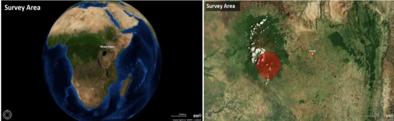
(20) 6. Project and Survey area 6.1VI Agroforestry Programme (VI AFP) The VI Agroforestry Programme is a Swedish NGO with over 30 000 private donors and in which the Swedish International Development Agency (SIDA) is an annual contributor. VI AFP has its base area around the Lake Victoria Basin. The VI AFP has 25 years of experience working with special planting methods of trees and crops, so-called agroforestry. The ambition of these methods is to mitigate land degradation and the negative effects from climate changes and so improve living conditions for the small-scale farmers who implement agroforestry practices. Moreover the VI AFP´s education in business enterprise and micro finance is also essential to achieve sustainable economic growth in the areas surrounding the Lake Victoria Basin. In addition, the work is to improve women´s social standing, by integrating them in the work with farming and business development is also vital for the VI AFP driven project in the countries around the Lake Victoria Basin. (VIAF, organization, 2011-03-05) The VI AFP approach to implement agroforestry strategies is to focus on the families in the project areas. In families knowledge of sustainable development can be anchored. When individuals grow up with agroforestry, they will also get experience of social and environmental benefits of these planting strategies. Because of this factor the VI AFP works directly with small-scale farming families. At present the organization works with around 150.000 families, which include one million people. Additional, the VI AFP ambition is to support many more in the future.. 6.2 Cooperation between VI Agroforestry Programme (VI AFP) and Dalarna University (HDa) Geographers from the Dalarna University and the VI Agroforestry Programme have been collaborating for some years in the countries surrounding the Lake Victoria Basin (Kenya, Tanzania, Uganda and Rwanda). During these years geographers from HDa have been working with two interacting methods. One method is through field work with GIStechnology (Geographical Information System) to map, analyze and present land cover and land use relationships, extension of agroforestry and degradation of tropical forests. The second method consists of interviews at household level, to generate profound knowledge of about issues in these survey areas. The cooperation between HDa and VI AFP has led to five previous MFS-studies and several field courses. This research has led to mutual exchange of knowledge between geographers from HDa and VI AFP´s staff and members of the households in the areas around the Lake Victoria Basin (Törnqvist & Westholm, 2009).. 6.3 Survey area The areas that have been investigated are located adjacent to Mt. Elgon slopes in the Western Province of Kenya, along the Kenya/Uganda border. The specific survey areas are Kopsiro, Cheptais and Kapsokwony (Project description, VI AFP 2010).. 15.
(21) Figure 1: Mount Elgon location. Figure 2: Survey Area. The overall climate in Mt. Elgon is moist to moderately dry. The general rainfall pattern over the area is bimodal as it comes in two seasons. The “short rains in October-December and the “long rains” in March-May. The annual rainfall is over 1270 mm and the temperature varies between 14°C and 24°C (Akoto, 2011). Subsistence farming is the main working chore in the survey areas. The dominant crops are maize, Irish potatoes, beans, onions and coffee. Free range is the common rotation system for the feeding of the livestock. (Akoto, 2011). Andisol is the dominant soil type in the survey areas (Project description, VI AFP 2010). Andisol consists of volcanic-ash parent material that, under favorable conditions, has high content of mineral nutrients and good ability for erosion-resistance (Britannica, andisol, 2011-12-13). The largest ethnic group in the survey areas are the Luhyas and the Sabots. Local cultural norms and groupings have influence on livelihood strategies and access to resource (Akoto, 2011). The poverty level is very high in Kopsiro, Cheptais and Kapsokwony. Extensive deforestation in combination with increased population and unsustainable agricultural practices have resulted in a decline of soil fertility and crop production (Akoto, 2011). Cheptais consists of 4500 km2 and the total population is approximately 160 000 (Akoto, 2011). Kopsiro consists of 6000 km2 and is one of six districts in the Western Province, Kenya. Kopsiro (Okello, 2009). The Kopsiro population is estimated to be 40 000. Kapsokwony has around 25 000 residents who are spread over an area of 2000 km2 (Kenyanredcross, 2007). When Mwai Kibaki was declared president on dubious grounds after the general election in 2007 clashes erupted within areas at Mt. Elgon. The estimate number of deaths from Mt. Elgon was 600. Moreover several people were displaced from their homes (Medard 2007, s. 339). The clashes were especially severe in Kopsiro, where several people were killed, injured and displaced (Akoto, 2011).. 6.4 Mount Elgon Integrated Watershed Management Project VI AFP has, in cooperation with the World Bank, recently launched a project in the Mt. Elgon water catchments’ area that targets 7000 households. The objective with the project is to improve living conditions and resilience against the effects of climate change. This through reducing the pressure on Mt. Elgon´s natural resources subsequently contributing to its rehabilitation (NDF, Mount Elgon Integrated Watershed Management Project, 2012-01-10 & Akoto, 2011). 16.
(22) Mt. Elgon is an extinct volcano that is located in western Kenya along the Kenya and Uganda border. The mountain has a vital role in the Kenyan ecosystem when it is one of the country’s five strategic and main water suppliers that feeds into the Nile Basin. Mt. Elgon is a source of at least twelve rivers which all drain into the Lake Victoria Basin. A serious problem affecting Mt. Elgon areas and its ecosystem is from land use changes which are mainly caused by extensive deforestation due to agricultural expansion and commercial forest overexploitation (NDF, Mount Elgon Integrated Watershed Management Project, 2011-01-10 & Akoto, 2011). Agriculture is essential for the Mt. Elgon economy, however the agricultural production is inefficient because of low productivity due to decreasing soil fertility, which consequently has put the Mt. Elgon districts under severe stress. This situation is mainly a consequence of a high population pressure, climate changes and unsustainable land use management. A concrete example of these is drought, flooding, reduced water availability, major soil erosion, loss of biodiversity and soil moisture. The land use in this district is characterized by extensive deforestation because of logging and agricultural expansion, which among other things, has lead to water stress by reduced volume in downstream water flow (NDF, Mount Elgon Integrated Watershed Management Project, 2011-01-10 & Akoto, 2011). The project´s objective will be achieved by sustainable land use management practices, in which agroforestry, agronomy, nutrient-, water- and livestock management, agricultural carbon dioxide sequestration and rehabilitation of land are essential elements within the project. These practices have the ability to decrease problems regarding to soil erosion and therefore increase soil fertility within farms. Moreover these practices have the ability to reduce the vulnerability against climate change (NDF, Mount Elgon Integrated Watershed Management Project, 2012-01-10). The project will also meet these elements by focusing strategies that are based on participatory and demand-driven advisory that can increase capacity building in the Mt. Elgon communities. One important component to guarantee sustainability of the intervention is to enlarge the awareness about the effects from climate change, natural resource management and protection of water resources within the Mt. Elgon communities (NDF, Mount Elgon Integrated Watershed Management Project, 2012-01-10).. 17.
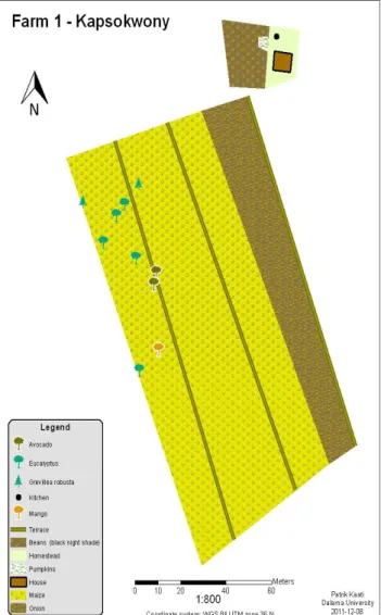
(23) 7. Result 7.1 Farm 1 - Kapsokwony Albert is a man of forty years of age. Albert has always lived in the area where his farm is located. His family consists of his wife Anne who is between 30 and 50 years, a boy around 5 to15 years and the two males between 15 and 30 years. These children attend primary- and secondary school and college. The parents´ biggest expenses during a year are the fees for these schools. Moreover the present cultivated farmland will be inherited by and divided among the children. Albert and his wife are both farmers and members of a group with 22 members. Albert’s farm consists of 3,25 acres and has been cultivated since 1998. The tenure system is communal land. Besides that, the family has more agricultural land close to their homestead. The most important crops on the farm are maize, beans and onions. These are processed using a plough. The family has five heads of cattle, five chickens and three donkeys. Of these cattle give the highest income. Albert’s and Anne’s rotation system to feed the livestock is free range. There is no irrigation on the farm, however, chemical fertilizers as DAP and CAN are used for planting and top dressing. Albert and Anne hire labor when it is time for planting or harvesting. They do no exchange products with other farms nor do they buy food, but their products are sold at a local market. Additionally, Albert and Anne give away products to relatives and vulnerable persons due to their Christian faith. All members of the family take part in planting. However, the woman is the one who does most work on the field while the men mostly take care of tree planting, management and they sell the farm products. Collecting water and firewood is mostly done by the female. It is approximately two km to the nearest Figure 3: Farm 1 - Kapsokwony spring water source. Due to this distance the household has lack of water for domestic use. The distance to obtain firewood is it approximately five km and the female spends about sex hours per day to collect tree species such as Bridellia, Chornet, Elgon teak and Eucalyptus to meet the family’s energy demand. In addition, these tree species are also used as fences. In particular, because of the clashes during the election in 2007, Albert has not planted any trees around his homestead. The unstable situation led to that Albert did not dare to plant any trees as it takes time for trees to provide income. However, he has planted about 20 trees on 18.
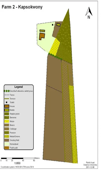
(24) the other farm outside the homestead and the seedlings for this he received from a plant nursery. Albert has problem with soil erosion, especially from heavy rain when it both destroys the crops and causes leaching of soil nutrients. To eradicate the erosion issue on the farmland certain soil and water conservation measures have been executed, such as terracing, grass strip and planting of tree species which are friendly for water conservation. Concerning factors on the subject of climate change Albert has since approximately ten years experienced changes in rain fall. Before this change, the rain generally came in February, today it is often a prolonged drought between December to April. Due to these changing climate conditions, the family plant their crops later than before. Albert’s knowledge about the objective with The Elgon Integrated Watershed Management Project is that the project will help them to plant trees to decrease erosion and thereby increase the soil fertility on the farmland. Besides the enlarged tree planting will also bring a positive change in the climate. Albert´s primary objective to participate in the project is that it will benefit the whole community. Situation compared to five years ago: The current situation of crop production, soil fertility, livestock number, fruits availability have all declined, which thus has lead to a worse situation compared to five years ago. Because of extensive deforestation, overgrazing and climate change the availability of fuel wood and timber is much worse today. These pointed factors together with high cost of living with, for example higher purchase prices have thereby brought a worse economic situation for Albert´s family. However, due to reduced livestock number and executed soil and water conservation practices the current problem with soil erosion is better compared to five years ago. Furthermore the water availability is also better due to protection of water sources and that the number of eucalyptus trees has been reduced on the agriculture land.. 7.2 Farm 2 – Kapsokwony Jacob cultivates five acres of farmland. However, it is only three acres that is utilized for agriculture purpose. This farmland has been cultivated since Jacobs’s grandfather moved to this area in 1994. The people living on the farm at present are ten people. Two boys and two girls are between 5 and 15 years and they go to primary school. Six persons are between 15 and 30 years and three of them are females. Two females and one man are around 30 to 50 years. In addition, it is also a female over 50 years living on the farm. The occupation for all these individuals is farming. The land tenure system is owned and it has been subdivided among Jacob´s brothers. Jacob´s children will inherit the farmland and it will be divided between them. Jacob is a member of a group with 30 members. Every family member plants, works in the fields and takes care of tree planting and management. When it comes to the sale of farm products this task is mostly done by the females at a local market. Furthermore the females are the ones who collect water and fuel wood. It is approximately 500 meters to the spring water source while the firewood mostly is collected within the homestead´s compound. About two hours of fuel wood collection is sufficient for a whole month and the common collected tree species are; Grevillea Robusta, Nandi flame, Nakhamia Lutea. Jacob has planted over 200 trees this year through his own 19.
(25) collection of wild seedlings and distribution from VI AFP. Besides that, the family replaces trees that are taken down inside the compound. The livestock on the farm consists of six heads of cattle, fifteen chickens and one donkey. The cattle give the highest income. These animals are fed by the rotation system zero grazing on the farm. The most important crops on the farm are maize, beans, onions and bananas. Plough and pesticide sprayer are the most common equipments used on the farm. Jacobs’s family solely uses using organic manure as fertilizer. Sometimes during planting and harvesting the household hires labor. No irrigation is used on the farm. The family’s food supply is satisfied through their own production or products exchanged with other farms. Moreover they also give away products to neighbors who are in vulnerable situation. They have no external income except these income sources and their biggest annual expenses are school fees. Soil erosion is a problem on the farm, especially in 2011 due to more occurrence of heavy rain which accordingly destroyed the soil. Moreover severe dry seasons have reduced the soil fertility. To overcome these erosion issues Jacob has executed land measures such as tree planting and terrace constructions along the contour lines in 2011. Jacob has experienced changes in rainfall during his working years in the area, especially from increased frequency of unpredictable downpour. Furthermore the drought has been exacerbated when it is prolonged from December to April. Before that, the rain usually came in March. This factor has led to that the spring water source occasionally dries up during these periods, which consequently causes lack of water for domestic use. However Jacobs’s family has never Figure 4: Farm 2 - Kapsokwony bought water because of its high cost. Besides that Jacob´s experience of more prolonged droughts has resulted in a decline of the number of livestock due to food shortage. Jacobs prime objective to join The Elgon Integrated Watershed Management Project is to be a role model in the community. This will be achieved his execution of more sustainable agriculture practices that thus can improve the living condition for him and the whole village. Moreover is it important to build up stronger groups so these elements will be achieved. 20.
(26) Jacob became aware of this project through a community meeting that was held by VI AFP. From the meeting Jacob got knowledge about agroforestry practices. Jacob believes that the goal of the project is to change people’s attitude to tree planting. For if this achieved it will subsequently improve the living condition by increasing production from crops and livestock. Additionally, the objective is also to reduce the effects from the climate change. Situation compared to five years ago: The present soil- fertility and erosion is worse against than it was five years ago. The main causes to this are increased frequency of heavy rain and dry periods. In addition, extensive deforestation due to agricultural expansion has a significant role in this situation. These factors have thereby also entailed worse conditions regarding productions of products from crops and livestock and availability of fuel wood, timber, fruit and water. Moreover higher purchase prices and decline variety of external income sources have led to much worse economic situation compared to five years ago.. 7.3 Farm 3 – Cheptais Isabella´s family consists of eight people, in which four children are between 1 and 5 years and two them are girls. One male and female are around 15 to 30 years while two of each sex are between 30 to 50. All of the family members are farmers and they do not belong to any group. Besides the head of Isabella’s family was born in Cheptais. The family has since three years cultivated 2,5 acres of communal land. And this land will be inherited by the children and it will be divided between them. The family has no agriculture land outside their homestead. In Isabella´s household everybody plants and sells farm products. However it is mostly men who work in the fields and as well as take care of tree planting and management. The women. Figure 5: Farm 3 - Cheptais. 21.
Figure
+5

Related documents
The importance of analysing human and non-human contexts, social structures, power, knowledge, complexity, and cross-scale and level dynamics, to understand and
It is clear from recent research that for Northem Zambia there have been a number of significant changes but also important continuities with respect to the techniques and strategies
Reward systems are used in all the companies and the fact that the rewards are based on individual performance and that theory suggest that a more entrepreneurial
This study therefore used SEI-PCS to assess whether the emergence of soybean trade telecouplings drove land use change outcomes in Uruguayan provinces between 2000 and 2011,
The slow processes take a small amount of time to reach equilibrium for each volume element that is pumped in or let out of the tank, the sums of these are displayed above. The
However, not all understory birds have problems with human activity, some species in Trochilidae family lives in the understory habitat but prefer to live around fallen tree gaps
In areas with high agricultural potential, like in the case with the town of Eldoret located in the Rift Valley in western Kenya, the P4P program aspires to help the FO:s to
The actors in the two rice supply chains in the Babati district are: rice producers, a Magugu producer group, middlemen and traders, mill owners, local markets
