1
SGS LTER Annual Report 2011 (DEB 1027319) Activities and Findings
Our research builds on our focus on climate, physiography, grazing, and land use as key determinants of the structure and function of the shortgrass steppe (SGS) ecosystem in the western region of Great Plains of the United States, with an emphasis on providing the necessary data to forecast how the system may change under projected global changes. As noted in past reports, the SGS has exhibited remarkable persistence in a semi-arid temperate environment characterized by high inter- and intra-annual variability in precipitation. The area is characterized by low-stature C4 grasses under a regime of grazing by large herbivores (i.e., historically by bison, now primarily as rangeland for cattle). In eastern Colorado, the SGS ecosystem exists as a mosaic of land uses including native prairie, prairie recovering on abandoned farmlands (including lands enrolled in the Conservation Reserve Program (CRP)), ranchland, tilled and irrigated farmland, and urban and exurban development. Our work has demonstrated the following: • Climate, grazing and fire remain important drivers of the SGS in maintaining current-day structure
and function. Many aspects of the SGS ecosystem are largely resistant to the effects of grazing and fire, but this ecosystem is highly responsive to variation in seasonal and annual precipitation. Short-term responses of the SGS to precipitation are consistent with those of the pulse-dynamic framework. Projected changes in magnitude and timing of climatic variables or anthropogenic inputs of nutrients that alter resource allocation above- vs. belowground can alter the structure and function of the SGS. • The SGS is acutely vulnerable to any disturbance that disrupts the belowground system. Recovery
periods are long or represent transitions to altered states. The composition and physiognomy of the SGS landscape is changing rapidly in terms of the contributions of native, agricultural and urban elements, each of which have different effects on belowground resources, and may alter the distribution and flow of energy, nutrients, water and organisms across the landscape.
• Changes in climate, CO2, land-use or other factors will have profound effects across multiple trophic levels and ecosystem processes given their impacts on the vegetation structure of the SGS. Increases in the aboveground canopy will likely increase the importance of grazing and fire in SGS, as fuel loads increase and grazing-mediated plant competition for light increases.
• The biotic, geological and geochemical processes of the SGS interact to drive the development of soils and ecosystems over tens to hundreds of thousands of years. These processes have shaped the development and degradation of soils, the structure and biological dynamics of landscapes and the hydrological functioning of the ecosystem. Understanding how these biological and geochemical processes interact, and understanding their vulnerability is key to quantifying how the major components of physiography regulate the rate and degree of ecosystem response to global change. With this background, we work to forecast responses of the SGS ecosystem to global change, defined in the broadest sense to encompass multiple factors including climate, human land use, and invasive species. Our research incorporates historical perspectives on how ecosystem determinants acted in the past, and we work under a framework of an SGS that is experiencing change in the relative importance of determinants of ecosystem structure and function. In addition to completing measurement and data archiving from long-term experiments, we engage in scientific initiatives important to our region, and continue cross-LTER and global synthetic analyses of data.
The success of the SGS LTER work is due in large part to the long standing and productive collaboration we have had with scientists with the USDA-ARS Central Plains Experimental Range (CPER), the site where most SGS LTER work has been conducted. An additional memorandum of understanding with the Pawnee National Grassland in Weld Co. extends the SGS LTER site to include approximately 80,000 ha of public land under management by the USDA Forest Service. This annual report provides a summary of our A) Research Activities, B) Information Management, C) Education, Outreach and Training Activities, and D) Project Management.
2 A. Research Activities
For 2010-2011, the project generated 37 papers in refereed journals (27 published papers, 4 in press and 6 submitted), 3 meeting abstracts, one book in press, and six book chapters published or in press. Most of our publications involved multiple authors, reflecting the collaborative spirit and interdisciplinary nature of the SGS-LTER research program. Two of the published papers included REU students as authors. The paper listed below with PhD candidate Sarah Evans as lead author was selected as the Editor’s Choice for November, 2011, in Ecology: http://www.journalofecology.org/view/0/jecedchoice996.html Evans, S.E., K.M Byrne, W.K. Lauenroth, and I.C. Burke. 2011. Defining the limit to resistance in a drought-tolerant grassland: long-term severe drought significantly reduces the dominant species and increases ruderals. Journal of Ecology 99(6):1500-1507. DOI: 10.1111/j.1365-2745.2011.01864.x. This annual report focuses on three new and ongoing initiatives - a Common Garden Study, a Rainfall Manipulation Study, and a Patch-Burn Studies - and two cross-site initiatives - NutNet at the SGS, and a cross continental comparison of temperate grasslands.
Common Garden Studies
(Amy Angert and Michael Antolin, Colorado State University)
The objectives of the common garden study are to examine the ecological genetics of blue grama (Bouteloua gracilis), assess its genotypic variation, and ultimately its responses to natural and anthropogenic disturbances. In 2011 we made extensive collections from 11 populations across the southern Great Plains. Our samples encompass greater than two-fold variation in mean annual
precipitation and 8 degrees Celsius variation in mean annual temperature among populations. Within each population, we sampled live tillers from 30 genetically distinct individuals from each of two transects, one along a xeric upland and one along a more mesic swale. The individuals were transported back to the CSU greenhouse (survival rates >98%), where we are currently conducting controlled pollinations among individuals from each transect to generate full- and half-sibling families.
In 2012, we plan to plant the seeds from these crosses into an extensively replicated field common garden near Nunn, CO (on USDA-CPER land adjacent to the Shortgrass Steppe Research and Interpretation Center (RIC)) to determine the degree of phenotypic and genetic variation in performance within and among populations of this dominant species. Future collaborative projects can build on this research infrastructure, for example by exposing genotypes to altered precipitation regimes or to different competitors.
Rainfall Manipulation Studies
(William Lauenroth, University of Wyoming and Kerry Byrne, Colorado State University)
Climate models predict warming and changes in precipitation, yet it is still unclear how these changes will alter soil water patterns in many ecosystems. In grassland ecosystems, where soil water most frequently controls ecosystem processes, climate changes will have dramatic effects on ecosystem
dynamics. Previous observational studies have reported that aboveground net primary production (ANPP) in grasslands is very sensitive to changes in precipitation. Yet we lack empirical-based evidence to support these observations. Further, these studies focus solely on ANPP, and lack descriptions of
belowground production (BNPP). This is an important gap in our knowledge, as BNPP represents 50% or more of total net primary production (NPP) in grasslands. We need to understand how NPP, not just
3
ANPP, will respond to changes in soil water to improve predictions of future ecosystem dynamics. We conducted a three-year water manipulation experiment (2008 - 2010) in the central grassland region of North America, USA to understand how changes in soil water will influence grassland ecosystem function in the driest portions of the central grassland region. Specifically, we experimentally increased and decreased soil water to determine if there was a difference in the sensitivity of the response of NPP (both the above and belowground components) to changes in soil water between sites.
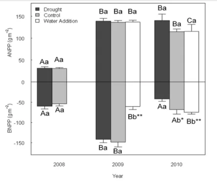
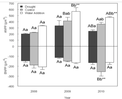
We were successful in changing the soil water content in our treatments, but these changes resulted in different, but significant responses in ANPP and BNPP at our two sites. At the shortgrass steppe, we found that neither NPP nor ANPP were sensitive to changes in treatment precipitation, and while we found BNPP was sensitive to changes in treatment precipitation, the response pattern was unclear (Fig. 1). In contrast, ANPP was very sensitive to changes in treatment precipitation on the mixed grass prairie, while BNPP was insensitive (Fig 2).
Our results indicate that we cannot rely on previous assumptions of ecosystem function in our effort to predict how ecosystems will respond to climate changes. We found that two similar grassland ecosystems showed dramatically different above and belowground production responses to soil water manipulations. Second, our results indicate that there may be differences in the periods of ecosystem sensitivity among ecosystems within the same biome.
Figure 1. Shortgrass steppe net primary production in drought, control, and water addition treatments. Upper case letters represent differences within a given treatment between years (all significant a P<0.05), and lower case letters represent differences between treatments within a given year. ** signifies P<0.05, * signifies P<0.10 and bars represent standard error.
4
Figure 2. Mixed grass prairie Net Primary Production in drought, control, and water addition treatments. Uppercase letters represent differences within a given treatment between years (P<0.05), and lowercase letters represent differences between treatments within a given year. ** signifies P<0.05 and Bars represent standard error.
Patch-Burn Studies
(David Augustine, Dana Blumenthal, and Justin Derner, USDA-ARS)
As part of the first experimental study in North America assessing interactive effects of fire and grazing on semiarid ecosystem dynamics, Drs. Derner and Augustine implemented prescribed patch burns in three replicate moderately-stocked pastures of shortgrass steppe in October, 2007. Patches (25% of each pasture) were burned in late fall each year from 2007-2010. The pastures were not be burned in 2011 to facilitate final sampling in 2012. Sampling efforts have emphasized: vegetation cover (basal and foliar), vegetation structure (visual obstruction), aboveground plant biomass by functional groups, standing dead biomass and remaining plant residue at the end of the grazing season, cactus injury and mortality to fire, cattle grazing distribution via GPS collars, densities of grasshoppers, grassland bird species and livestock weight gains. We have consistently observed that livestock weight gains have not been negatively affected by the implementation of patch burns (Figure 1).
Figure 1. Livestock weight gain responses to patch burning in shortgrass steppe (Derner and Augustine, unpublished data)
5
Long-term experiments have substantial utility for determining relationships of livestock weight gains to seasonal precipitation, which can provide valuable understanding pertinent to the potential consequences of climate variability. A long-term (1939-2008, 70 years) data record of yearling Hereford heifer weights grazing at light (20%), moderate (40%) and heavy (60%) grazing intensities from pastures grazed May-October is available from the USDA-Agricultural Research Service Central Plains Experimental Range, in north-central Colorado for the shortgrass steppe. We synthesized beef production (kg/ha) data for influences of: 1) warm-season precipitation (May-September), 2) cool-season precipitation (October-April), 3) previous year’s precipitation (October – September 1 of prior year), and 4) precipitation from the previous two years. Warm-season precipitation and precipitation from the previous two years influenced beef production for light grazing, previous year’s precipitation was the main influence on beef production with moderate grazing, and cool-season precipitation and previous year’s precipitation influenced beef production with heavy grazing. Implications for land managers include incorporation of these relationships between seasonal precipitation and livestock gains into modeling efforts that would enhance strategic planning and reduce risk in highly variable environments to improve sustainability of livestock production systems.
Cross-Site Activities - Progress on NutNet at the SGS
(Julia Klein, Cynthia Brown and Laura Dev, Colorado State University; Dana Blumenthal, USDA-ARS, and Kimberly La Pierre, Yale University)
Theory predicts top-down and bottom-up forces may interact in complex ways to influence plant
community structure. To address the ways top-down and bottom-up forces interact, the Nutrient Network (NutNet) was established to collect data from a broad range of sites in a consistent manner to allow direct comparisons of environment-productivity-diversity relationships. The three focal questions of NutNet are: (1) how general is our current understanding of productivity-diversity relationships? (2) to what extent are plant production and diversity co-limited by multiple nutrients in herbaceous-dominated communities? and (3) under what conditions do grazers and/or fertilization control plant biomass, diversity, and composition and how do these forces interact? The NutNet research at the SGS is contributing to the global NutNet experiment and is also focused on comparing three NutNet sites spanning the broad
precipitation gradient of the Great Plains. This three site comparison is being led by Kimberley La Pierre, PhD student from Yale University. These sites are located within shortgrass steppe (Shortgrass Steppe LTER, CO; SGS), mixed-grass prairie (Saline Experimental Range, western KS; MIX), and tallgrass prairie (Konza LTER, northeastern KS; TGP).
We continued our fourth year of nutrient addition and herbivore exclosure treatments at the SGS as part of the global NutNet experiment and the Great Plains comparison. This involved addition of nutrients (N,P, K) separately and in combination and re-establishment of exclosures during spring 2011. In summer 2011, we estimated plant species composition, light interception, and harvested plant biomass by species. We also collected, processed and weighed our first round of litter bags, which were in the plots for one year, and collected soil cores, for a NutNet-wide soil C and N analysis. La Pierre continued her Great Plains NutNet comparison by conducting additional sampling at the SGS site. Her activities included measuring a suite of plant traits, sampling arthropod diversity, and nutrient availability. To date, nutrient additions have been shown to result in increased production at all three sites, but the response is dependent on precipitation in SGS. Vertebrate herbivore removals only have a significant effect across time in MIX. However, a build-up of litter in the NPK fenced treatment at TGP in 2010 resulted in a decrease in above-ground live biomass, indicating herbivores may play an important role in the breakdown and distribution of litter in this system. The dominant plant species, particularly the dominant grasses, contribute the most to the increase in above-ground biomass observed with nutrient additions at all three sites.
6
Cross-Site Activities - Controls on soil organic carbon and nitrogen in Inner Mongolia, China: A cross continental comparison of temperate grasslands (published in Global Biogeochemical Cycles, 25, GB3006, (2011), doi:10.1029/2010GB003945.)
(Sarah E. Evans, Colorado State University; Ingrid C. Burke and William K. Lauenroth, University of Wyoming)
Most global ecosystem models assume that controls over soil organic matter are alike in climatically similar regions. In this study, we tested the generality of controls over soil organic carbon (SOC) and soil organic nitrogen (SON) in temperate grasslands. We measured organic matter pools in Inner Mongolia, China, along the Northeast China Transect, and analyzed the relationship of SOC and SON to climate, soil texture, and land use variables. We then compared our data to values simulated by a regression model developed in the U.S. Great Plains and also to Century model simulations. We found that, as in the U.S. Great Plains, climate and soil texture variables could explain a large proportion of variation in observed SOC and SON, but a regression model developed in the Great Plains overestimated SOC and
underestimated SON in Inner Mongolia. Using Century, we found that simulated SOC and SON values were sensitive to both inclusion of altered land use and changes in N deposition and that the model that best fit our data included higher intensity grazing and N deposition values higher than that in the Great Plains. This model also produced aboveground net primary production (ANPP) values comparable with values observed in the literature for Inner Mongolian grasslands, but these values were higher than ANPP predicted by previously published regression models. These results suggest that different controls over SOC and SON cycling in Inner Mongolia may affect our ability to predict SOC and SON pool sizes using relationships in other regional models.
B. Information Management
(Nicole Kaplan, Information Manager and Bob Flynn, GIS and IT Manager)
Nicole Kaplan and Bob Flynn are working with SGS-LTER Researchers on information management in support of data integration and analysis and metadata documentation to facilitate publication of scientific findings from our long-term project. We work closely with SGS and other LTER site researchers and graduate students on improving data quality. We are performing data aggregation and synthesis, and implementing LTER standards and best practices as we are generating data products as tabular data and metadata packages through field data processing and spatial data and metadata layers within our Geographic Information System (GIS).
SGS LTER researchers and staff have created an inventory of core datasets to be preserved and made available through the LTER Network Data Portal. This inventory consists of over one hundred datasets that represent over thirty years of interdisciplinary research. The curation of this information will help build future capacity for understanding the structure and function of shortgrass steppe. Nicole and Bob continue to increase our web data delivery locally with online public access to data and accompanying high level metadata content in Ecological Metadata Language (EML), built on emerging best practices and standards for the LTER Network. Over the winter, our field sampling off-season, information managers worked closely with Kevin Meierbachtol, our field crew leader, to address both the quality and quantity of data and metadata served online by appending and updating data and metadata content within the SGS Relational Database Management System (RDBMS). Kevin has the understanding of the context and collection methodologies of our field data and metadata, which helps us improve linkages between data, metadata, and information communicated in publications, websites and other venues. Our existing RDBMS is built to contain and serve our researchers’ contact information, related publications and datasets. The conceptual design of the RDBMS also links our metadata and datasets with the broader
7
SGS-LTER conceptual framework, as well as LTER core areas. Kevin has the tacit knowledge and local context of how and why data values were obtained from the field and/or the lab. Knowing the origin and process of the data facilitates quality control of the dataset packages we generate. Nicole and Bob continue to work with Network Information System developers at the LTER Network Office on harvests as to submit new and revised data packages as EML from the SGS-LTER system to the LTER metacat. Most recently Bob and Nicole have been addressing issues of how to generate EML for SGS-LTER spatial data from the GIS. Bob continues to contribute to the development of proposed LTER spatial data standards and best practices through participation in activities of the LTER GIS Working Group via video-teleconferencing. We also continued our work with Kevin, last winter, to make improvements in the geographic location metadata of sampling sites associated with our core datasets. We are working closely with our partners at the Agricultural Research Service to collect more precise information regarding the location of historical experimental treatments, fence lines and other land or project
management attributes to create a more useful digital record of long-term study sites on the Central Plains Experimental Range for the future.
We continue to monitor data accessed directly from the SGS-LTER website (http://sgslter.colostate.edu). The SGS-LTER data access tracking tools on our web server allow us to record data downloads for various reasons, such as making an inquiry into how our online data access system works, conducting college coursework and scientific research, and applying data to GK-12 education or conservation efforts. One hundred twenty-four individuals registered themselves on the local system and 115 of them
downloaded at least one dataset. There have been a total of 281 downloads since July 2010 including data from long-term monitoring of primary production, meteorology and physiography at the shortgrass steppe research site. These numbers represent a thirty-percent increase in data downloaded from our website over the last year.
We continue to contribute to cross-site efforts in Information Management as well for the Network synthesis groups. Enabling data integration by providing open access to data and useful metadata documentation is critical to support research activities for the network. We have begun to collaborate with the developers of the EML congruency checker, a program for assessing the validity of EML content in data packages, to ensure the metadata we have produced is of high quality and to help us identify where our EML generation procedures may need to be modified. We are focused on sharing specific core, long-term datasets that are representative of the shortgrass steppe. Over twenty years of ungrazed basal cover data from the long-term grazing study was prepared and packaged for Scott Collins and colleagues to conduct a cross-site comparison of community dynamics in response to inter-annual changes in rainfall. A box of pantograph data, originally collected from the Jornada Experimental Range in the 1920s was discovered in SGS-LTER field station storage and sent to the JRN site for further examination. Nicole has been cooperating with James Brunt and Bob Waide at the Network Office in their efforts to create test cases for how to improve the availability of data for synthesis across the network. SGS efforts in
inventorying assets, managing project goals and timelines, and analyzing costs will inform future network efforts.
Nicole also serves as the co-founder of the Information Management Governance Working Group (GWG). The GWG has prepared the Information Management Committee Terms of Reference, which is now in its’ final review stages before going for a vote by the LTER IMC. Nicole and Karen Baker (PAL, CCE) lead this effort in recognition of the importance of ensuring effective governance for the LTER Information Management Committee, because the number of members and work of our community has grown significantly to address the development and adoption of best practices and standards impactful to the 26 LTER sites currently in the Network. Governance for information management systems and
organizations will continue to be important as more principal investigators require management and open access of their data and information. Nicole and Bob are identifying additional venues within the broader
8
ecological research community at Colorado State University to share their experiences and skills gained from working within LTER Information Management. They are able to share different approaches to challenges in data management that may apply in other National Science Foundation funded projects that now require data management plans. SGS-LTER Information Management and other staff have
cooperated with NEON Operations Managers and Field Ecologists, new to working in this region, on site specific techniques for experimental design and methodologies as well as sample and data processing procedures that we have developed while working in the shortgrass steppe.
C. Education, Outreach, and Training Activities
Teacher Professional Development 2010-2011: The SGS-LTER has maintained strong partnerships with K-12 schools in eastern plains and Front Range of northern Colorado. The work reported here was reported in our 2011 annual report for our previous award (DEB 0823405). During 2010-2011 we expanded our work to include efforts that are more teacher-centric in terms of professional development.
Schoolyard LTER 2011-2012
The SGS Schoolyard LTER initiative is based on a partnership between the SGS-LTER, Colorado State University, The University of Northern Colorado, Greeley School District 6, and the Poudre School District. The partnership is supported by the SGS-LTER and coordinates several other grant initiatives. The projects listed below were designed by the teachers at our partner schools and supported through the SGS-LTER and our MSP program. The teachers and students developed proposals for the work over the summer of 2010 with follow-up activities during 2011. Funds from the Schoolyard supplement to our previous award (DEB 0823405) were used to initiate these efforts, while funds from this award will sustain them through the next year. The reports presented below were prepared by teachers from each school.
Franklin Middle School
(Teachers: Steve Linkous, Rebecca Ramirez, Aubrey Tate)
Project goals this year are to provide opportunities for students to engage in lessons which will help them understand how to conduct investigations, independently and in groups/teams. We will also provide students with hands-on explorations with plants utilizing a greenhouse which was pre- fabricated last year at Maplewood Middle School and is ready to be installed at the school grounds of Franklin Middle School. As the schools merged, a decision was made not to put the greenhouse up and then have to take it down again, so it is new and ready to be made available to all of the science teachers and students in our building (6th -8th grade). We will also provide students with an ecology unit through an after-school science enrichment program and provide students an opportunity to gain a better understanding of biodiversity of any given ecosystem and why it is important in our world.
Greeley West High School (Teacher: Kelly Longacre)
Students learned research techniques and practiced them in authentic nature setting. The students also learned why Greeley West Park has been made into natural area and what features define natural area and watersheds. During this activity, students developed skills in recording, collecting and analyzing data, including the use of tables, graphs, and Microsoft Excel spreadsheets. They also learned basic concepts in plant taxonomy, mapping, surveying, soil nutrients, water quality, and invasive plant species. Finally the students completed an Agriscience Fair application and booth for the state contests.
9 John Evans Middle School
(Teacher: Donna Stevenson)
The 7th grade Life Science students gathered phenological data on 3 plant species on the grounds of John Evans Middle School. They will also gather daily weather data, recording it using a wireless weather station. In addition to data gathering they also documented phenological changes using cameras purchased from the grant. This will continue through the whole fall season. We then did the same thing starting in spring. Students made observations and documented phenological changes until the plant species fully leafed out. Students shared their data with the National Phenology Network and also created a web site to display the data and photographs that they have gathered.
Preston Middle School
(Teachers: Erin Panozzo, Mary Hunter-Lazslo)
The goal of this research project was to have students at Preston Junior High School engage in scientific discovery through field experimentation, where the steps of scientific inquiry are modeled and practiced. The project helped students explore the biological diversity of a riparian corridor, as well as make them aware of the factors that affect biological diversity, including human impact. The project will have three component parts, divided by grade level: Sixth grade explored decomposition of plant materials and the organisms involved. Seventh grade students investigated stream biological diversity and adaptation, while eighth grade students investigated plant diversity and invasive species in a restoration project. The project also has a long-term impact; both projects will study the biodiversity of the same region, which will allow students to form connections between habitat type, environmental variables, and the diversity of the stream and the grasslands.
Seventh grade field research was conducted at the Environmental Learning Center (ELC) in Fort Collins, Colorado and at the Preston Pond, a water retention and irrigation pond just south of Preston Middle School. The eighth grade field research is a restoration project at the Preston pond, and the sixth grade project looked at decomposition using leaf litter-bags at different microenvironments around the school. Union Colony Middle School
(Teachers: Cathy Hoyt, Jennifer Parrish)
Our goal at Union Colony Schools was to initiate school-wide compost and recycling program. Through this program we wanted to educate staff and students about the benefits of composting and recycling. Students and staff had expressed interest in beginning a recycling program so we consulted with Clean Air Compost, a local company whose objective is to support our school and community efforts in sustainability by significantly lowering the amount of trash our school produces and diverting our waste to produce a valuable resource-compost. Clean Air Compost provides student and teacher education and awareness of what can be composted and how to properly divert compostable materials, the positive environmental impact of diverting waste from landfills, and the value of compostable waste as an important resource and crucial nutrient source for local agriculture, farming, and streamside restoration. Clean Air Compost also provided bins for recycling paper and other recyclable materials at no charge when we use their composting service.
Clean Air Compost provided consultation and support regarding in-house collection of compostable materials, including how to set up a system in our cafeteria that is conducive to composting for a large number of students. They also provided Union Colony with containers lined with compostable liners to
10
collect compost and picked up the bins on a weekly basis. Lastly, they provided classroom teachers with a monthly report on Union Colony’s total compost production by the pound and what that equates to in greenhouse gas reduction from the landfill.
Union Colony Schools is the first school in Greeley to try to implement a school-wide composting program. Our hope is that the program will able to be continued past the pilot program and become an integral part of our school. As other schools in the community see the benefits and feasibility of composting they may also try to adopt a composting program in their schools.
Cross-LTER Site Education Initiatives
The SGS-LTER site has maintained the cross-site initiatives reported last year and expanded its cross-site initiatives to include other LTER sites and share its models with them. The SGS-LTER has initiated the following partnerships, some of which have been discussed above:
• NSF MSP 2008-present: Culturally relevant ecology, environmental literacy, and learning
progressions. (BES-LTER, KBS-LTER, LNO-LTER, SBC-LTER, SGS-LTER). Designed to study the learning progression that students from different backgrounds undergo to understand
ecological concepts (see description presented above).
• USDA AFRI SPE 2009-present: Summer Soil Institute: Addressing Environmental Challenges with Current and Emerging Techniques from Microbial to Global Scales (SGS- LTER, MCD-LTER). Designed to develop modules with field and laboratory protocols that focus on soil chemistry, soil physics, and soil biology for undergraduate and graduate instruction and for K-12 teachers in K-12 classrooms.
• NASA CCE 2010-present: The goals of the NASA Climate Change Education grant are to (1) improve the science content knowledge and preparedness of middle and high school teachers, (2) increase the science content knowledge of middle and high school students, (3) increase the awareness, opportunities and participation of middle and high teachers in content-based
professional development activities, and (4) Broadly disseminate our model to districts across the country. NASA MODIS, Landsat, GIMMS, and Okinos or DigitalGlobe data sets will be used to develop modules that are aligned with science content standards for integration into K-12 courses. We will scale-up by providing training to PD providers from the 26 NSF LTER sites
(www.lternet.edu) so that they can adapt the modules to their regions. D. Project Management
Project management at SGS LTER continues as it has since it was changed in 2009. Central management of the project is by an Executive Committee (SGS-EC), Mike Antolin (lead PI until 11/1/2010), John Moore (lead PI since 11/1/2010, Justin Derner, Eugene Kelly, and Nicole Kaplan (Information Manager). The Executive committee works with the PI’s, both to manage project budgets and to map out the general scientific directions of the project. Justin Derner is a scientist with the USDA ARS Rangeland Resource Research Unit (ARS-RRU) stationed in Cheyenne, WY, and represents our partners with the Central Plains Experimental Range where the majority of SGS LTER research has been conducted. We use video-conferencing to include members from several institutions at different locations.
The direction of scientific research is guided by Science Steering Group, comprised of active scientists on the project who provide specific advice about the scientific enterprise (e.g. design and implementation of research projects, data analyses, interpretation of results). Members of the Steering Committee are expected to attend monthly Science Meetings (second Wednesday of each month), with additional ad hoc
11
meetings for more specific topics. All members of the SGS LTER community are invited to meetings, videoconferencing is available for all remotely-based members, and meeting notes are made available to the community. Currently the Science Steering Group includes: Amy Angert (CSU), Mike Antolin (CSU), David Augustine (USDA-ARS), Cynthia Broun (CSU), Indy Burke (UWyo), Justin Derner (USDA-ARS), Niall Hanan (CSU), Gene Kelly (CSU), Julia Klein (CSU), Alan Knapp (CSU), Bill Lauenroth (UWyo), Daniel Milchunas (CSU), John Moore (CSU), Jack Morgan (USDA-ARS), Bill Parton (CSU), Paul Stapp (Cal State Fullerton), Heidi Steltzer (now Fort Lewis College in Durango, CO), Joe von Fischer (CSU), Matt Wallenstein (CSU).
To coordinate the logistical aspects of the SGS LTER project (e.g. timing of field work, long-term climate monitoring, inputting metadata to the Information management system) we also schedule monthly “Nuts ‘n’ Bolts” meetings. Again, members of the SGS LTER project are invited to attend the meetings, but all staff are expected to attend Nuts ‘n’ Bolts meetings, we provide videoconferencing for all remotely-based members, and meeting notes are made available to the community.
Under this award the SGS LTER has two ongoing subcontracts (two previous subcontracts have been completed): with collaborators at the University of Wyoming (Drs. Indy Burke and William Lauenroth) for continued work on long term ANPP and plant phenology, long-term biogeochemistry and climate manipulation experiments; and with our USDA-ARS collaborators (Drs. Justin Derner, David Augustine, Dana Blumenthal and Jack Morgan) to continue long-term experiments on the Central Plains