Energy
Z!RME-97RME
UNITED STATES ATOMIC ENERGY COMMISSION GRAND JUNCTION OPERATIONS OFFICE
EXPLORATION DIVISION
RME-97
AIRBORNE RADIOMETRIC SURVEY,
JICARILLA APACHE INDIAN RESERVATION, NE.W MEXICO
by
William L. Chenoweth
May 1957
(Grand Junction, Colorado)
Mesa State College Library Grand Junction, CO
OFFICE MEMORANDUM -- UNITED STATES GOVERNMENT
TO R. D. Nininger, Assistant Director for Exploration, DRM, Washington
DATE:
jUN 21
1957
FROM E. A. Youngberg, Assistant Managerfor Operations, Grand Junction SUBJECT: TRANSMITTAL OF REPORT RME-97 SYMBOL: ED:ERG
Transmitted herewith are copies 1, 2, 3, and
4
of a report by William L. Chenoweth, entitled "Airborne Radiometric Survey, Jicarilla Apache Indian Reservation, New Mexico", dated May 1957. The master copy is being sent under separate cover.Distribution as shown on page 2, the distribution sheet, will be made after receipt of comments from the Jicarilla Agency.
Enclosure:
Report (copies 1, 2, 3, and 4) CC:
(wi
encl.) A. E. Jones E. E. Thurlow A. E. Granger H. D. Wolfe E. W. Grutt J. W. King S. R. Steinhauser M. L. Reyner L. P. Barrett R. A. Beard T. B. Nolan A. P. Butler A. L. Brokaw C. H. Bowen W. L. ChenowethUNITED STATES ATOMIC ENERGY COMMISSION GRAND JUNCTION OPERATIONS OFFICE
EXPLORATION DIVISION
RME-97
AIRBORNE RADIOMETRIC SURVEY,
JICARILLA APACHE INDIAN RESERVATION, NEW MEXICO
by
William L. Chenoweth
May
1957
(Grand Junction, Colorado)
-1-RME-97
AIRBORNE RADIOMETRIC SURVEY,
JICARILLA APACHE INDIAN RESERVATION, NEW MEXICO
Distribution
AEC, DRM, Washington (R. D. Nininger) AEC, DRM, Grand Junction (A. E. Jones) AEC, DRM, Grand Junction (ED-E. R. Gordon) AEC, DRM, Denver (E. E. Thurlow)
AEC, DRM, Salt lake City (A. E. Granger) AEC, DRM, Albuquerque, N.,Mex. (H. D. Wolfe) AEC, DRM, Casper, Wyoming
(E.
W. Grutt) AEC, DRM, Rapid City, S. Dak. (J. W. King) AEC, DRM, Austin, Texas (S. R. Steinhauser) AEC, DRM, Phoenix, Arizona (M. L. Reyner) AEC, DRM, Ishpeming, Michigan(L.
P. Barrett) AEC, DRM, Lima, Peru (R. A. Beard)USGS, Washington (T. B. Nolan) USGS, Denver (A. P. Butler)
USGS, Grand Junction (A. L. Brokaw) AEC, DRM, Grand Junction (C. H. Bowen) AEC, DRM, Grand Junction (W. L. Chenoweth) AEC, DRM, Denver (T. L. Boyle)
Supt. Jicarilla Apache Indian Reservation
-2-(Series A) COPY Number ~ 2, 3, 4, and master 5 6, 7, 8, 9 10 11 12
13
14
l5
16
17
18 19 20 22 23 24 25-49 incl.} \ )
RME-97
CONTENTS Abstract • • • • • • • 0 • 0 0 • • • • 0 • • • • • 0 • • • • • • • • • • • • Page 4. Introduction. • • • • 0 0 • • • • • • • • • • • • • • • • • • • • • • • • •4.
Topography, climate, vegetation and access. • • • • • • • • • • • • • • • •
4.
Geology • • e o . • • • • • • • • • • • • • • • • • • • • • • • • • • • • •
7
Stratigraphy • • • • • • • • • • • • • • • • • • • • • • • • • • • 7
Igneous rocks. • • • • • • • • • • • • • • • • • • • • • • • • • • 8
Structure. • • • • • • • • • • • • • • • • • • • • • • • • • • • • 9
Uranium deposits • • • • • • • • • • • • • • • • • • • • • • • • 9
Airborne survey procedure • • • • • • • • • • • • • • • • • • • • • • • • • 10
Ground investigation of radiometric anomalies • • • • • • • • • • • • • • • Conclusions • • • ••• • •
•
• • • • • • • • • • • • • • • • • • • • • • • •References. • • • • • • • • • • • • • • • • • • • • • • • • • • • • • • • •
ILLUSTRATIONS
Figure 1. Location map, Jicarilla Apache Indian Reservation, New Mexico •• Figure 2. Areas covered by
Reservation. • •
airborne survey, Jicarilla Apache Indian
• • • • • • • • • • • • • • • • • • • • • • • • Figure 3. Geologic map showing location of airborne anomalies, Jicarilla
-12
13
5
6
Apache Indian Reservation. • • • • • • • • • • • • • • • • • • • 11
-3-AIRBORNE RADIOMETRIC SURVEY,
JICARILLA APACHE INDIAN RESERVATION, NEW MEXICO
ABSTRACT
An airborne-radiometric survey of part of the Jicarilla Apache Indian Reservation, Rio Arriba County, New Mexico, was conducted by the Atomic Energy Commission from November 8 to December 16, 1955.
Three areas of anomalous radioactivity were found in the Point Lookout sandstone, apparently due to detrital titaniferous "black sand" deposits.
INTRODUCTION
Selected areas--underlain by Cretaceous sedimentary rocks on the Jicarilla Apache Indian Reservation were systematically surveyed from the air as a partial evaluation of the uranium possibilities. The uranium potential of the area is unknown as there ~as been little prospecting.
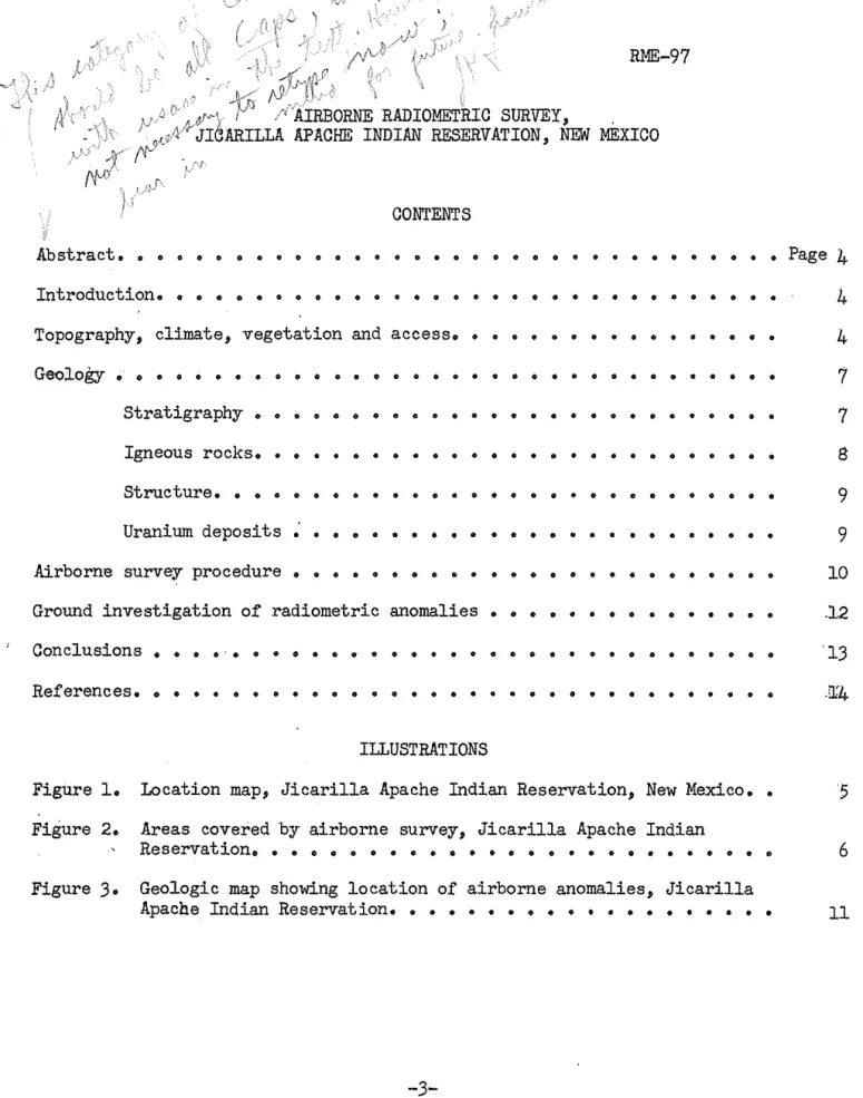
The Jicarilla Apache Indian Reservation, an area of about 1,250 square miles, is located in north central New Mexico, largely in Rio
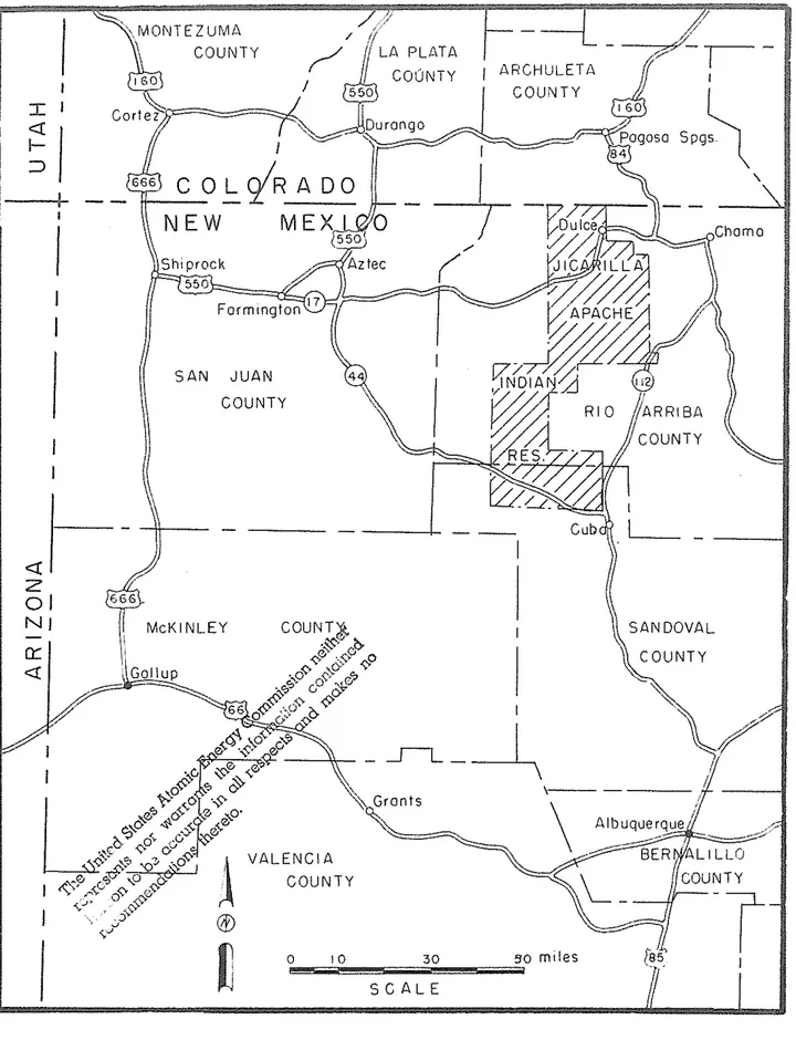
Arriba County (fig. 1). The aerial survey covered only the northern part, where Cretaceous rocks are exposed. Due to the configUration of the out-crops the flying was extended slightly beyond the Reservation limits into the Tierra Amarilla Grant, and other private lands in the Lumberton and Monero areas (fig. 2).
The survey was m~de by technical personnel from the Engineering Services and Geologic Branches of the Exploration Division, Grand Junc-tion OperaJunc-tions Office. -The survey began November 8, 1955, and was com-pleted December 16, 1955.
Acknowledgment is due Allan W. Galbraith, Superintendent, and
James-S. Reyos, Land Department, Jicarilla Agency, for their cooperation during the survey. George E. Shaner piloted and maintained the aircraft.
TOPOGRAPHY, CLIMATE, VEGETATION AND ACCESS
The topography, climate and vegetation of the area are transitional between the San Juan Mountains to the north and the semiarid parts of the San Juan Basin to the south. The altitude ranges from 6,700 feet to 9,200 feet above sea level, most of the area investigated being between 7,500 and 8,000 feet. Local relief ranges between 200 and 1,000 feet. The gently sloping mesas and wide valleys on the east gradually give way to flat-topped mesas and deep canyons on the west.
-4-! / \MONTEZUMA \ COUNTY - ,/
-? r-/ I <{ f- I ::::>O~iR
C
NEW
Shi prock#
550 Form,ngton 17 SAN JUAN COUNTYJ--
-tl---z
01 NJ 0:: <{ McKI NLEY ARCHULET Alit
'''~
COUNTY~
84I
J
.-'(
ARRIBA Cub SANDOVAL Grants 0;;",.,...;',;;0"""""" __ """3;;,0""" .... ="'5 .. 0, m i! e s S CAL EFigure L Location map, Jicarilla Apache Indian Reservation, New Mexico
MAY 1957 RME -97
R 3 -
'l~'--r-/
32 N T. 29 N. T. 8 N.1\
a Ko - Anlmos formation- - -~Q~
--'-I', .
.!:R~.I.!E:... -'
COLO R A 00_--1NEW MEXICO
"'t:7ik-::HM~O
().Nn~ ~
1
Do m eArro~
,,)"t
LO\:ut
:c~
.. j covered Kmv- Mesaverde airborne survey SCALE--
aus dike Figure 2. ApacheAreas covered by airborne survey, Jicarilla Indian Reservation, New Mexico
II
6
Yellow pine forests, with some aspen and scrub oak, cover the mesas, Pinon and juniper grow at lower elevations, and sagebrush and grasses cover the valleys, Rainfall is not abundant, but thick snow hampers activity during the winter months,
The narrow-gauge Denver and Rio Grande Western Railroad line from Alamosa to Durango, Colorado, passes through Dulce in the northern part of the Reservation, state Highway 17 crosses the area from east to west, and State Highway 112 is nearby on the east, A network of unimproved dirt roads provides fairly good access to most of the area,
The Jicarilla Apaches, only some 1,140 at present, derive their live-lihood mainly from sheep and cattle raising,
GEOLOGY Stratigraplty
The geology of the area has been described by Dane (1946, 1948), The sequence of sedimentary rocks attains a maximum t4ickness of 10,000 feet, and exposed rocks range in age from late Jurassic through early Tertiary,
Eocene
&
Paleocene Paleocene&
Cretaceous Upper CretaceousMesaverde group
Upper Jurassic Jurassic System
Table 1, - Stratigraphic Column Group and Formation
San Jose formation Animas formation Fruitland formation
Pictured Cliffs sandstone Lewis shale
(La Ventana sandstone tongue (of the Cliff House sandstone (Menefee formation
(Point Lookout sandstone Mancos shale
Dakota sandstone Morrison formation
Thickness in Feet
2,OOOj (top eroded) 1,500 to 3,000 0-160 0-100 2,OOOj 30-180 80-130 75-160 2,000£ 175-200
100j (base not exposed)
The Jurassic system is represented by the Morrison formation, consist-ing of white, gray and buff, lenticular, cross-bedded sandstone and pebbly conglomerate, with green and gray clay, sandy shale, shale and siltstone,
-7-Cretaceous System
Dakota sandstone is a tan. hard. quartzitic sandstone, with softer tan and white sandstone, carbonaceous shale and black shale.
Mancos shale is a gray to black shale with calcareous sandy shale, fine-grained sandstone and thin fossiliferous limestone.
Mesaverde Group
Point Lookout sandstone is a tan to white. massive to thick bedded sandstone; transitional downward into the Mancos shale.
Menefee formation consists of gray shale and clay; white. cross-bedded. coarse grained, lenticular sandstone; carbonac~ous shale and
sand-stone; and coal beds.
La Ventana sandstone is a brown, hard sandstone, with gray sandy shale and soft tan sandstone; grades upward into the Lewis shale •.
Lewis shale is a gray shale, with sandy shale and thin-bedded cal-careous sandstone in uppermost and lowermost parts.
Pictured Cliffs sandstone is a white cross-bedded sandstone, present in only the northern part of the area; transitional downward and laterally southward into the Lewis shale.
Fruitland formation consists of gray shale and clay; some green and gray argillaceous sandstone; carbonaceous shale and sandstone; coal beds at or near the base; it is present only in northern part of the area, and grades laterally southward into the Lewis shale.
Cretaceous and Tertiary Systems
Animas formation consists of olive green clay, greenish gray ande-sitic sandstone, yellow and gray sandstone and conglomerate; the lower part is Upper Cretaceous in age.
Tertiary System
Paleocene and Eocene series
San Jose (Wasatch) formation consists of soft red and gray clay, yellowish-brown to white sandstone, arkose, and arkosic conglomerate.
Igneous Rocks
Two types of igneous rocks are present in the area. Archuleta Mesa, north of Dulce, is formed by a sill of augite andesite 300 feet thick, which has intruded the rocks of the Animas formation. The other type is
-8-lamprophyre, in a swarm of dikes extending southward nearly 40 miles from the New Mexico--Colorado line, in a belt nearly
15
miles wide centered in Ro 2Wo ·but extending easbard into Ro 1 Wo a.l1d westward to Ro 4 Wo (figo 2; see Dane,1948
for details of distribution) 0 Dane considers both types ofintrusions to be Miocene in ageo
Structure
The Jicarilla Apache Reser~ation is on the eastern side of the San Juan Basin, Along the eastern edge of the area su~eyed there is a belt of structurally high, north- and northwest-trending anticlines and domes, called the Archuleta Anticlinorium, This belt separates the San Juan Basin from the Chama Basin to the easto The trend of the structures is north-westerly in the su~ey area, and persists into Colorado, Farther south
the trend is generally nor-thwaz'd, parallel to that of the Nacimiento Mountains, Numerous faults are present in the area, but displacements on the
majc;>rity are less than 100 feet, The greatest displacement is on the fault which forms the eastern margin of the Monero Dome, a few miles northeast of the Reservation (fig, 2); there the east side has been down-dropped about 1,000 feet,
Uranium Deposits
No uranium deposits are known in the immediate vicinity of the Jicarilla Apache Indiru1 Reservation, However, the geologic formations present in the Rese~ation are kr,own to contain a few uranium deposita elsewhere in northwestern New Mexico,
Uranium of possible economic importance is concentrated in coal seams· of the Menefee formation immediately beneath the La Vent ana sand-stone, on La Ventana Mesa, south of Cuba, New Mexico, Carnotite is also present in the La Ventana sandstone, Baltz
(1955)
has recently noted trace amounts of uranium in the Mesaverde coals in the Monero area near theRese~ation,
A small amount of uranium ore has been produced from a sandstone lens in the Fruitland formation at the Boyd claims near Farmington, New Mexico 0
Minor uranium mineralization associated with carbonaceous material and limonite sta~.ning has been found in the Cretaceous Ojo Alamo sandstone near Cuba, New Mexico, This formation is not recognized to the north in the area of this su~ey, but sandstones in the basal part of the Animas forma-tion, in the su~ey area, are probably equivalent to the Ojo Alamo (Dane,
1946),
Similar minor occurrences in the Tel~iary San Jose formation areknown in the Cuba area and other parts of the San Juan Basin,
-9-AIRBORNE SURVEY PROCEDURE
Areas covered by the survey are shown on figure 20 The formations surveyed include the Morrison, Mesaverde group, Fruitland, and basal part of the A..1'limas 0
The upper part of the Morrison formation is exposed in a canyon where the Rio Chama crosses North El Vado Dome, northeast of El Vado Reser-voir (figo 2)0 This small area was completely covered by rim flyingo
The Mesaverde group forms a series of gently dipping mesas between Horse Lake and the south boundarY of the north half of the Reservationo Those mesas have east-facing escarpments and west-dipping slopes. Similar conditions 'are ,found to the north on Dulce and Monero Domeso A combina-tion of rim and grid flying was used to give the Mesaverde complete coverageo
The Fruitland formation and basal part of the overlying Animas for-mation were sur1l'Ejyed as a unito This unit forms a rim along the Canyon of the Rio Navajo north of Dulce, and along the escarpment south to Wirt Look-out. South of the Lookout, exposures are poor and largely coveredo Rim flying was used entirely for this unito
A few flight lines to check the San Jose formation in the area of the dike swarm were planned. but were never flown due to prolonged bad weathero
Grid flying consisted of utilizing a pattern of flight lines spaced at 100-foot intervals o1l'er the surface of the terraino A height of 50 feet was maintained aEl nearly as possible ab01l'e the surfaceo In flying the rim exposures. as man,y flight lines were made at different elevations as neces-sary to insure a4equate coverageo
Control for the sUM'ey was maintained by use of Soil Conservation Service 15:minut~9 semi~controlled ai~photo mosaics. scale 1:62,5000 Flight lines' were. located by visual reference to prominent landmarks such as roads. lakes. and topographic featureso //~"::C'/':3:;1t,;C!y ,fdC)"j.,/,
The flyine:; was done in a Pipel~/PAc'18" 135 horsepower'Super Cub 9
equipped with a'".~ aimornet.!f"I~~o Operations were based at Farmington. NewJ4erlc0 9 where aviation gas and oil and Civil Aeronautics Administration forecast facilities are availableo
)
~XPLANAT!QN
Structure contours
drown on bose 'of Mesaverde group
_V
Fault, with dawnthrawn- side Scale: I ", I mile , "
.
.
I-,.
,.
,.
," '" - .,..
-.
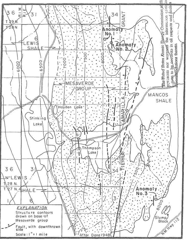
-Figure 3. - Geologic map showing location of airborne
anomalies, Jlcarilla Apache Indian Reservation, New MeXICO
11 '
GROUND INVESTIGATION OF RADIOMETRIC ANOHALIES
Hea\ly wInt.er sno'W's d.elayed ground irrv6stigat.ion of the anomalies until April 1956, The three anomalies a1"8 all due to detrital heavy min-eral placers, commonly called "black sands", 'rhese black sands are ancient beach concent.races in t.ransition zones bet~,een marine and non-=marine sedi= mentary beds, The deposi.ts are associated with clean. massive, well sorted, littoral marine sarIastone beds of the Point. Lookout sandstone:- which are overlain by lagoonal coal and shale of the Menefee fOlCmation in the Hesa~ verde group of C)I'eGacoo'l:U!i age, S:Lm1lar deposits in Wyoming have been
des-cribed by Murphy and Houston (1955), and others in the San Juan Basin by Chenoweth (1956) 0
The deposits form resistant.9 :b<O!!.'"-stained,9 elongate, lenticular zones containing ilmen.ite9 zlrcoD s ga:rnet.J9 monazite)) :ruti.le,9 spIne.l$) e-pi=
dot.e9 amph~.bole$l magnet:lteD and t,ourmal1:ne aEd several urddentified opaque
winerals believe-d to conta.irc. tl:;ot'iumo
Radioa.cti vity in the black sand deposits is att!"ibuted chiefly to ur-anif6l"'OU5 z:i:r:"con and mon.azl'f:,eo The u!~anil1m content.9 so far as now !mown is too low for economical rE'C01reryo Titan:ium oc(;urs chiefly J.n ilmenite
and in anastase formed f:rom :!lmenlte by ~b"'on leaching; the iron becomes dis-persed in the cement as hematite, The "Gitaniwn contents whi,ch averages 16
percent Ti02 in other deposits in the San ,Juan Basin may possibly be of some value in the futureo
Anomaly Noo 19 in the NWi, SW~9 secu 3:) To 28 No.9 R<J 1 E0 9 occurs
at a da.rk r6ddish~hr-ovm9 very fine-grained resista.nt, hematite'"'stained
sand-stone lens at the top of the Point Lookout sandstonE', The outcropping ledge can be traced fo',< 700 feet in a No 450 W, direction before becoming
covered and. has an apparent thl.clmess of 5 feet, The wid th of the lens could not be observed due to the cover of overlying bedso Radioactivity at the deposit is aborrt 5 tllnes nor-mal backgr01J.nd on a La Roe FV=5 Scintil ...
la-tion Detectoro
Anomaly Noo ;2 is believed to be a continuation of anomaly Noo 1,9
but separated by a thin COirer·- of oVBr'1yi:ng Menefee fonnationo It is also locat.ed in the SW~, 86C, 5. To 213 No, R., 1 E, A lens of rust-brown, very
flnea~gl~aineds well cemented l:imon:tte stained san.dstone occllrs in the top
of the Point Lookout on each side of a small canyon in the mesa rim, This resistant sandst.one has a p,!:'"obable thickness of 5 feet and can be traced north!t16stward for about 1.0500 feet befo:r'8 beccrrJ..ng covered" It has an ap-parent "rldth of about 200 feet., L:!ke anomaly No, 1, the radioactivity is about 5 times background,
Anomaly Noo 39 :lIT the SE~9 seco 2:) Tu 27 NU$I Ro 1 Eo (projected)
is on the Tierra Amarilla Grant abou.t I! miles east of the Res6FJ'a.tion boun= daryo A lens of rust~br'O'WTlb 1J"E'F;[ fine=g:r"ainedj 'well cemented, limonite
stained sandstone occurs at the V'el~y top of the Point. Lookout sandstone and is overlain by baeaJ carbonaceous shale of the Menefee fo:r-mationo The heavy
mineral zone is about 5 feet thick and is exposed along the mesa rim for about 1,000 feet. Radioactivity at this outcrop is also about 5 times background. Prospectors searching for this anomaly, after it was posted January 15, 1956, also found identical radioactive material on a slumped block of Point Lookout sandstone about one-half mile southeastward near State Highway 112 (fig. 3).
The uranium content of the three deposits located by the airborne survey is estimated to be less than 0.01 percent U30g' However, the titanium content may be of interest as it will probably average between 15 and 20 per-cent Ti02•
CONCLUSIONS
As the result of the airborne survey, three new heavy mineral de-posits were found in the Cretaceous sedimentary rocks. Titanium, rather than uranium, may be of possible importance in this type of deposit. No ura-nium deposits of apparent economic significance were found.
-13-REFERENCES
Baltz, E. H., Jr., 1955, A reconnaissance for uranium in parts of New Mexico and Colorado, 1954: U. S. Geol. Survey TEM-929, U. S. Atomic Energy Commission, Tech. Inf. Service, Oak Ridge, Tenn.
Chenoweth, W. L., 1956, Radioactive titaniferous heavY-mineral deposits in the San Juan Basin, New Mexico and Colorado: Geol. Soc. Amer. Bull. v. 67, p. 1792 (abs.).
Dane, C. H., -1946, Stratigraphic relations of Eocene, Paleocene, and latest Cretaceous formations of eastern side of San Juan Basin, New Mexico: U. S. Geol. Survey Oil and Gas Inv. Prelim. Chart 24.
Dane, C. H., 1948, Geologic map of eastern San Juan Basin, Rio Arriba County, New Mexico: U. S. Geol. Survey Oil and Gas Inv. Prelim. Map 78.
Murphy, J. F., and Houston, R. S., 1955, Titanium-bearing black sand deposits of wyoming: Wyoming Geol. Assoc., Tenth Annual Field Conf. Guidebook, Green River Basin, p. 190-196.