ANALYSIS AND SYNTHESIS
OF FLOOD CONTROL MEASURES
by
Kon Chin Tai
September 1975
ANALYSIS AND SYNTHESIS
OF
FLOOD
CONTROL MEASURES
by
Kon Chin Tai
HYDROLOGY PAPERS COLORADO STATE UNIVERSITY
Chapter !1. 2 3 4 5 6 7 TABLE OF CONTENTS ACKNOWLEDGMENTS ABSTRACT . . . INTRODUCTION. 1.1 General
1.2 Objective and Scope of the Study. 1.3 Significance of the Study . . . CLASSIFICATION OF FLOOD-CONTROL MEASURES.
2.1 The Criteria and Classification 2.2 A Review of Classification Schemes.
2.3 The Present Context of Flood-Control Problems 2. 4 The Class'ification Used in the Study.
ANALYSIS OF FLOOD-CONTROL MEASURES. 3.1 Prevention Measures 3.2 Prediction Measures
3.3 Floodplain Proofing and Floodplain Zoning Measures. 3.4 Physical Control Measures
3.5 Flood Insurance Measure .
SYNTHESIS OF FLOOD-CONTROL ~IEA.SURES
4.1 Synthesis of Prevention Measures with the Other Measures. 4.2 Synthesis of Prediction Measures with the Other Basic Groups. 4.3 Synthesis of Floodplain Zoning and Proofing with the Other Basic
Categories of Measures . . . . 4.4 Synthesis of Intensive and Extensive Flood-Control Measures with the
Other Categories of ~leasures. . . . o • • o • • • 4o5 Synthesis of Flood-Insurance Measure with the Other Categories of Basic
Measures. . . . o • o • • • • • REGIONAL INPUT-OUTPUT ~IODEL FOR FLOOD CONTROL
5.1 Regional Input-Output ~!odel Applied to F load-Control Systems. 5.2 Mathematical Equation for the Input-Output Model . .
5.3 Forecast of Flood Damage in Floodplains . . . .
5.4 Testing of the Inter-regional Input-Output Model in the Case of the Arkansas River Basin. . . .
5.5 Results of the Inter-Regional Input-Output Analysis 5.6 Results of Economy-Flood Linkage.
DISCUSSION OF RESULTS . . . v v 1 1 2 3 5 5 5 7 7 9 9 12 16 18 26 32 32 32 35 39 47 49 49 51 51 53 54 54 57
6.1 General Discussion of Results 57
6.2 Criteria of Measure's Effectiveness 57
6.3 Criteria for Comparing and Ranking of Alternative Flood-Control Measures. 58 6.4 Absence o·f Dichotomy between Economic Efficiency Objective and Social
Security Objective. . . . . . . .. . . . 58 6.5 Discussion of Results Obtained for the Case Study of the Arkansas River 58 6.6 Controver.sial Issues Involving Risk and Protection. . . . 58 6.7 Integrated Structural and Nonstructural Flood-Control Measures Versus
Solely Structural ~leasures. . . . 58
6.8 Economy-Hydrology Sectoral Implications 60
6o9 Flood Problem of Pueblo City. . . . 60
6.10 Project Yield . . . . . . 65
6.11 Resilience in Economic Performance. 65
SUM~IARY, CONCWSIONS AND RECOMMENDATIONS. 7.1 Perception of the Flood Threat. 7.2 Conclusions . . 7.3 Recommendations . 66 66 66 67
TABLE OF CONTENT (Cont.) Chapter Page REFERENCES. 68 APPENOIX A. 71 APPENDIX B. 72 APPENDIX C. 78 APPENDIX D. 83 APPENDIX E. 86 APPENDIX F. 90
ACKNOWLEDGEMENTS
The writer is indebted to his major advisor, Vujica Yevjevich, Professor of Civil Engineering, for suggesting the scientific line and for his guidance in the Ph.D. study leading to this paper.
The study is the result of the final phase of the writer's academic program at Colorado State University under the sponsorship of United Nation Development Project /75/15 in Malaysia.
The writer also acknowledges the help by the other members of his Ph.D. Graduate Committee, namely to Professors Paul C. Huszar, E. V. Richardson, Neil S. Grigg and Edmund F. Schulz. In addition, the writer ackno·wledges the help by several faculty members at Colorado State University who have given their time to discussions leading to the writer's efforts to develop the presented methodology in depth, as the main thrust of the study. Listed in the alphabetical order they are: William S. Duff, Mechanical Engineering, Lewis 0. Grant, Atmospheric Sciences, Sanford L. Gray, Economics, John W. Labadie, and Thomas G. Sanders, Civil Engineering, and Willis W. Shaner, Mechanical Engineering. ·
The writer is grateful to the supporting institutions and individuals of his country of his studies the United States, namely the University of ~~laya and the Government of Malaysia, the Vice-Chancellor of University of Malaya, Professor Ungku Aziz, and the Secretary-General of the Economic Planning Unit, Tan Thong Yaw Hong .
in the Sri . Appreciations are extended to UNESCO, UNDP, the Institute of International Education, and Colorado State University Civil Engineering Department for their overall arrangement of the writor's studies in the United States.
The topic studied is the part of research activities on floods, a project sponsored by Colorado State University Experiment Station, and the research project GK-31512x "Stochastic Processes in Water Resources" sponsored at Colorado State Universit~ by the U. S. National Science Foundation, with V. Yevjevich the princial investigator of these projects. Staff time, supporting activities and the printing cost of this paper are covered by these two research projects.
ABSTRACT
Adopting scientific methods of analysis and synthesis, flood control planning will become more meaningful and relevant to present and future flood control needs, if the principles and concepts are established from the very beginning.
A methodology incorporating four 'basic structural elements is presented, involving (a) a classification scheme for flood control measures,
(b) analyses of the measures classified,
(c) subsequent syntheses of the various mixes of the measures to get the optimal, and (d) the impact of the proposed measures on the regional economy.
Previous efforts in flood control planning have been carried out piecemeal and often the optimal or best strategy is missed by the concern over details rather than the synthesis of all their significant aspects.
The analyses of nonstructural measures, especially land use and insurance, demand a common yardstick to measure costs and benefits comparable to structural measures.
The synthesis of measures is in a state of flux, with no reliable principles and methodology to guide the planning process. A methodology is presented herein which incorporates the difficult problem of hydrologic interdependence of flood control measures.
The methodology of analyses and syntheses of measures is tested for the Arkansas Drainage Basin, above John ~lartin Dam, in Colorado. The drainage area is about 18,900 square miles, having a thriving economy, but is bur-dened with recurrent flood problems, both along the main stem of the Arkansas River and its major tributaries.
The economic synthesis is an additional element in this methodology, because the economic model enables the planner to examine the adverse effects, if any, of project proposals, and in addition, to alert him to any sig-nificant variables that could undermine the viability of flood control proposals. Sociological, environmental and sediment damages are potential factors in addition to direct flood damage. The Isard-Chenery Regional Input-Output ~lodcl is applied to flood planning. It appears to the writer of this paper that this may be the first attempt to apply input-output modeling to flood control planning in a comprehensive but exhaustive manner. The methodology rationalizes the hydrology-economics linkage which is the real synthesis between flood
Chapter 1 ,.· INTRODUCTION
1.1 General
The historical perspective on the flood control planning process shows conclusively that a predominant reliance on the one-or-two measure approach of the past is no longer valid. The role of static planning where flood problems "'ere viewed as problems that could be solved once and for aZZ may be over. The philosophy, premises, and the inertia of the past are giving way rapidly to innovation.
The absence of a sufficiently thought-out concep -tual framework has handicapped attempts so far to for-mulate guidelines and methodology that would help to search and to identify that flood-control strategy which is both sound and adaptable to present and fu-ture flood control needs. Attempts which have been made to formulate guidelines and methodologies have not been very successful.
In the United States, the historical perspective on flood control policy traces out a three phase de-velopment:
(a) 1936 to 1966. The thirty year period be-tween the passage of the Flood Control Act of 1936 and the issuance of Executive Order 11296 of 1966 was a time for the supremacy of the technical structural measures, which by themselves alone were conceived to be sufficient in solving the flood problems for some time to come. No account was taken of the effect of project induced growth and the associated land en -hancement benefit and it is this very dynamic growth effect that has been largely responsible for increased residual flood damages (Fig. 1-1).
(b) 1966 to 1973. During the seven year period up to 1973, the inadequacy of the past is realized and a greater reliance is called for on nonstructural mea -sures in official flood control policy. Experience with the sole use of structural measures has resulted in a steady increase in the total flood damage. To reverse this trend, official policy requires the con-sideration and integration of nonstructural measures with structural measures.
(c) 1973 to 1975. The two year period marks an accelerated refinement of official flood control pol-icy. Local initiative is to be marshalled, in meeting the problems of flood control and flood damage. A greater degree of self-reliance is called for by the Federal Government, from the state, local and municipal governments and from the occupants of floodplains. This devolvement of federal responsibility to local initiative is marked by the passage of Flood Disaster Protection Act of 1973.
However, despite this progressive evolution and innovation of official flood control policy of the nation, recent efforts to develop a procedural guide-line and methodology have not yet been successful. Some of the basic difficulties in this direction arise from one or more of the following major problems:
(1) the lack of a comprehensive conceptual frame-work not having enough alternatives of flood control measures considered, analyzed and synthesized;
(2) investigators are handicapped by distraction in analysis of details rather than the synthesis of all the significant aspects of flood control measures; and 0(1) Averog• Annual Domoges Fig. 1-1
I
s
0 0 (a)lev•l of Prolec:tion p
0
0
(b)
(c)Static and Dynamic Cases of Structural Flood Control Protection. The Static case is shown in (a); the dynamic case in (b); and in (c), D(p
0) , the average annual flood damages at protection level p0; R(p0) , the reduction in flood damages at protection p
0 and r(p0) , the residual flood damages at protection level p
0 (Adapted from Arvanitidis et al., 1970).
(3) a fascination for the enigmas and methodolo-gies of operational research, systems approach and computer programming, so that investigators are more concerned with the defense and acceptability of their techniques rather than with the problem at hand--the search and identification of a flood control strategy, sound and viable, from which the best mix of measures could be established in order to solve the complexi-ties of flood control.
A review of the last ten years' efforts by inves-tigators at academic institutions shows that James
(1964) was the first to attempt integration of non-structural measures with structural measures in flood control planning. However, the number of nonstructural alternatives were limited mainly to flood-proofing and land use. The danger with restricted consideration of a subset of measures is that the optimum from this subset is not necessarily the optimum from the total set of measures. It might be argued that in 1964, James was using only a slide rule and table calculator to analyze tho subset of flood control measures, thus limiting the number of alternatives which were ana-lyzed. Even when James developed with Cline and Villines (1968) the University of Kentucky Flood Con-trol Planning Computer Programs II and Ill, no further nonstructural alternatives were analyzed. Cline reaf-firms this position by stating that the programs "are by no means capable of analyzing all potential mea-sures in all possible flood damage situations.''
There is also a serious defect in James' method-ology. The least-cost approach states that when the sum of the costs of a combination of flood control measures is less than the total of no-measure cost
(the average annual flood damage), then the subset of measures is justified. However, the average annual flood damage does not need to remain constant, espe-cially in urbanized areas with growth and land en-hancement benefits. His optimization model is static, with this conclusion confirmed subsequently by Arey and Bauman (1971) for the least-cost model. Even in 1972, concerned that economic criteria can and should be used in planning the nonstructural flood control measures, James (1972) presented again the least-cost optimization model. The least-cost optimization pro-cedure is valid as long as circumstances and average annual flood damage remain unchanged.
Day (1973) presented a methodology for planning land use and engineering alternatives for floodplain management. His mode'l is more for particular land-use planning and development activities intended to find the optimum allocation of land for residential, com
-mercial and open spaces. The selection between the nonstructural and structural measures do not appear to be systematic, limited to flood proofing and land fills on the one hand, and channels and dams, on the other. lt is not clear to this reviewer what important aspect of flood-mitigation strategy he has considered, analyzed and planned.
Cortes-Rivera (1973) presented what is expected to be a methodology for planning comprehensive flood control projects by mathematical programming. Again, the methodology is applied to an application of land-use zoning to protect two pieces of agricultural land behind a levee system interacting with an upstream flood detention reservoir. The applicability of the methodology proposed appears to be restricted to up-land watersheds with predominant agricultural activity. The objective of his study seems to be, to demonstrate the usefulness of his mathematical programming ap-proach using parametric linear programming and dynamic
programming for flood control planning. Hence, a fas-cination with the intricacy of programming methodology and the data needs of a specific planning situation obscures somewhat the necessity for more compl·ex al-ternatives to be considered. The optimum of the land-use measure interacting with the levee and the up-stream dam may not necessarily be the global optimal mix of measures and hence does not reflect the posses-sion of a sound strategic basis in planning for that flood-prone area.
In addition, it appears that there is a dispro-portionate concern for the future by delving into eco-nomic and population projection and their future ef-fects on flood control when the present problems of flood control are not adequately confronted. There are two reasons for this projection into the future. First, most of the watersheds studied by several in-vestigators are upland agricultural watersheds with very little urbanization and development. Secondly, the extent of flood damage is not that extensive along the main stem of the river. Hence, a projection into the future indicates what sequential expansion of the project is necessary.
1.2 Objective and Scope of the Study
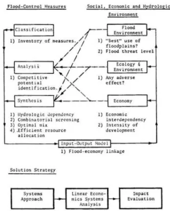
The objective of this study is to formulate an integrated investigative framework for the best tacti-cal approach to analysis and synthesis of flood con-trol and flood mitigation. A sound approach should be based on scientifically oriented flood control strate-gy which will provide solutions to flood, river and sedimen~ problems, for the improvement of the environ-ment, and to enable people to live in harmony with natural extreme events (Fig. 1-2).
Flood-Control Measures
I) llydrolog ic ucpendcncy 2) Combinatorial screening 3) Optimol mlx
4) .ffflci"nt resource ollocat ion
Social, Economic and Hydrologic
Env1ronment
I) Econontic interdependency 2) lntcn•i ty of
development Input-Output 'IOJcl
I} Flood-econocy linkage
Solution Strategy
Fig. 1-2 Flow Chart Indicating Plan of Study and
The basis of this approach must be relevant to both present flood control needs and to a long range flood control strategy which could account for dynamic changes. A sufficient, built-in flexibility for fre-quent review of basic premises and principles and
al-lowance for innovation is necessary.
The need for such approaches has already been enunciated by White (1972), who pointed out. that, al-though the sophistication of scientific investigation and engineering analysis and design h~ advanced in strength and with rapidity, the skill to make inte-grated investigations of the whole array of flood-control measures has not kept pace. It was, he wrote, the concentration of special aspects of those engi-neering programs that have obscured the significance of complementary works in the field of flood warnings, land-use regulations, flood proofing and insurance. The result is that the net effect of many of the
ear-lier flood-control works have ended up to be negative rather than positive, in comparison with what had been expected and planned for.
While White (1972) has laid down the philosophical hypothesis for this study's objective, the conceptual framework and basic guidelines have been advanced in a workable procedure by Yevjevich (1973, 1974), with: (a) the prerequisite for a modern systems ap-proach to planning by the systematization, classifica-tion, analysis and synthesis of all known flood-con-trol measures, with the optimization of goals as the result of the synthesis of all the flood-control mea-sures; and
(b) that the procedure would lead to a general strategy of how to treat floods in a modern society of any cultural and economic background.
This researcher has incorporated the philosophy and scientific concepts of White and Yevjevich in the objective of this study.
The ~hases followed in this study are:
{a) To search and to identify the general flood-control strategy for a given test region,
(b) Out of several areas reviewed in Colorado, the test region selected is the Arkansas Basin in the State of Colorado,
(c) Classification is made of all known flood-control measures applicable,
(d) Analysis is conducted of each measure as though each is independent and its relative potential evaluated in relation to the region's data when avail-able, and extrapolated or assumed when such data were ·not available.
{e) Synthesis is made of measures with a combi-natorial screening of mutually dependent measures where necessary, and allocation of resources by dynam-ic programming for measures with multi-dimensional, multi-stage approach.
(f) Hydrology-economics linkage is provided for, with the use of the Chenery Input-Output ~~del {1960), adapted to flood-control needs.
(g) The potential use of the empirical input-output economic model is two fold:
(i) to examine the probable and possible effects of proposed flood-control measures on the economic, environmental, ecological and social sectors of the selected river basin, and
(ii) to provide a basis for relating the pres-ently formulated strategy in flood control with a longer-range strategy in anticipation for the need to constantly revise basic premises and approaches, adapting to changes in technology and economy, and other dynamic changes which are presently unknown and/ or unexpected.
1.3 Significance of the Study
The significance of this study is to demonstrate the viability of an integrating methodology in the flood-control planning process. Planning for flood control is defined as a search for those optimal com-bination of measures that help to accomplish the gen-eral goal of flood control.
The integrating methodology which incorporates the scientific framework given by White (1972) and Yevjevich (1974) offers:
(a) a criterion that would control strategy for a given basin and
shape present flood-flood-stricken river
(b) concurrently establish standards and crite-ria against which all current proposed and/or estab-lished flood-control projects for that region could be evaluated in their relative order of merits, with the need for improvement and modification thereon shown.
The necessity to ~nalyze all measures, some of which are very dissimilar in their performance and yield of benefits, requires the formulation of common yardsticks in measuring economic net benefits, as the criterion adopted for economic efficiency in this study. Procedures for measuring benefit to cost ratio for structural measures are fairly well established; they are less so for nonstructural measures such as flood insurance.
The study establishes a conceptual framework by which a common measure of effective economic net bene-fit, stemming from dissimilar measure alternatives, can be evaluated. The study offers a methodology which has been in common use in the field of economics but has not been applied to flood-control problems. The modification of the regional Isard input-output em-pirical model to the study of flood related economy is attempted. This methodology answers a need expressed by Yevjcvich (1972):
"Total damage is usually separated into direct and indirect damage. An economy is made up of interrelated activities; and the direct damage in one sector affects the production or efficiency of its interconnected economic sectors, even though these sectors may not be in the flood plains. Therefore, not only is a survey of direct damage of importance, but also a methodology is needed which permits assessment of all effects, indirect and direct."
By July 1, 1975 all floodplains in the continen-tal United States would either have to be registered or they would have to forego the future federal aid and assistance and benefits which could go to the aid of flood-plain residents when a severe flood occurs.
Therefore, ~he resul~s of s~udies like this may be useful in pursuing ~he ~asks of ~he con~inuing flood-con~rol effor~s.
Many coun~ries of ~he world are now in one of ~he three categories of economic developmen~: (a) depress-ingly slow, (b) negative growth or (c) stationary growth. The proportion cf r.ational product that is
affected by fluctuations of natural disasters, such as droughts and floods, amounts in some instances to as much as 2-2.5 ~ercent (White, 1972) or even more. This percentage is the expected annual growth rate for some countries in the immediate forseeable future. To the extent that such an amount could be saved or decreased by a sound flood-control strategy, the integrated
flood-control measures and. long-range policy may help
Chapter 2
CLASSIFICATION OF FLOOD-CONTROL MEASURES
2.1 The Criteria and Classification
Classification criteria are given and the
classi-fication scheme of flood-control measures presented. These criteria and classification should be broad so
as to include all known flood-control measures. A criterion should be included of whether the river is
adjusted to man's convenience through engineering flood.-control measures or the conceptual opposite, that man's activity is adjusted to the convenience of
the river. This criterion is important in the
classi-fication of nonstructural measures, as supplemental to
structural measures or as mutual alternatives.
Another criterion to consider is whether the classified measures would affect the short-term or long-term readjustments of the streams to flood con-trol. Mackin (1948) proposed a synthesis between the engineers and the geologists ideas, advocating the
necessity to give more attention to the latter's point of view.
The engineer is concerned primarily with the short-term reactions and adjusted events of streams to
damming, shortening and deepening operations, and other river-training measures. The geologist views
erosional and depositional problems in river valleys
as the long-term responses of the river to changing
conditions which control the flow activity of the river. The emphasis of ~1ackin is that the very natural
changes are in many instances comparable with the
changes introduced by man.
Mackin's hypothesis is that the engineering mea-sures which alter the natural equilibrium of rivers by diversions, dammings and channel improvements place a·
stress on the river system already under natural
equi-librium. In terms of Le Chatelier's general law, it is predictable that a reaction must occur by displacing
the equilibrium in a direction which tends to absorb
the effect of the stress. To quote Mackin, the
engi-neer who laters the natural equilibrium will often
find that he has "a bull by the tail and is unable to
let go." He has to correct or suppress desirable phases of the chain reaction in the stream to the ini -tial str>ess that is imposed. In the end, he would necessarily place an increasing emphasis on the study of genetic aspects of the equilibrium in order that
one m.ay work with rivers rather than merely on them.
It pays to remember the principle, well-recognized but not extensively implemented, that "in dealing with rivers, better results may be achieved with less human
effort by working with the water, rather than against it ... " (Nackin, 1948) .
2.2 A Review of Classification Schemes
~~ite's Classification Scheme. White (1945) has given a classification scheme based on human adj ust-ment to floods. The objective of the classification was to conduct flood-control policy analysis (Fig. 2-1). Adjustment to floods is defined as an ordering of occupance to floods and to the flood hazard. The or-dering may be systematic or unsystematic, rational or irrational, conscious or unconscious, so long as an observable arrangement of occupance in relation to floods is present.
Ptreeptlon bJ maucer of :
Adjustment n-tlcol <.hoic. t'osord FJoo4 Tnhw:JI~ eftiCt.K:f £<-.-lt. S,..lol lli!IUg. ft~<.lit.ol do>u
"A..ic,.lt.f Fig. 2-1 0 0 0 0 0 0 0 0 0 0 0 0 0 0 0 0 0 0 Diagram of justments 1964). 0 0 0 0
Elements in Decisions as to Floods (Adapted from
0
to Ad-ll'hi te,
Eight major classes of adjustments are presented.
It is interesting to note that the meteorological mea-sures of prevention are not listed. Some limitations
in White's classification scheme exist. The
classifi-cation is based on a geographical approach to evaluate the flood problem in the United States with a better
method needed to distinguish between physical and non-physical adjustments. The industrial society's re-sponse to floods has generally b.een physical in nature
(Arey and Bauman, 1971). In addition, the clas
sifica-tion based on human behavior is difficult to i ncorpo-rate in adjustments dependent on technology.
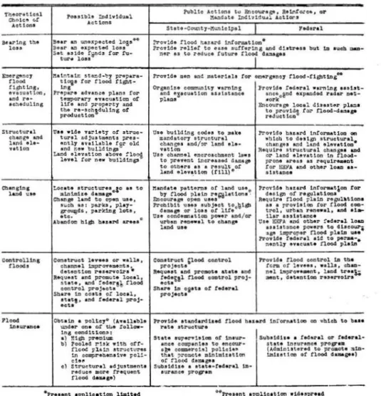
Kates' Classification Scheme. Kates (1962) p
re-sents a classification scheme designed to reduce the future flood damage. It shows the theoretical range of choices available to federal, state, and municipal
authorities and to individuals. Basically, the action to reduce future flood damage is divided between the format for community action of federal, state and local levels and the individual level, with the
possi-ble interaction between these two levels. In addition, the classification allows for the interaction of al
-ternatives which are the actual elements of a
compre-hensive flood-damage reduction program (Table 2-1). The Kates scheme omits the measure on prevention,
meteorological measures and physical control by exten-sive watershed measure. Its relative advantage is to allow for interdependence of technology and human
be-havior. Yet, in common with other classification schemes, it cannot serve for evaluating the potential
effectiveness of various damage-reduction alterna-tives. Hence, the program for future flood damage re-duction could be substantially altered if the initial
expectations and choice of alternatives do not meet the practical realizations of chosen alternatives.
Arey and Bauman's Classification Scheme. Both Arey and Bauman (1971) have come up with a classifica-tion scheme to serve the review and revision of feder
-al policies in flood control. The theoretical range of adjustments to floods are broadly classified as direct and indirect adjustments. Adjustments are those ac-tions taken by individuals or groups of individuals in
Theor•t1cal C'hntca c.! Aotlon• B•ar1na th.e loa• E:ler.,ency tloo4 ;;~~~f~, a.nd re-ac~ecSultng Strvc.tural c.han£• and. hn4 ale ... vat t.oa Chanslnl land \:I t controlllnl Clooch Ploo4 1ntW"abC8
TABLE 2-1 ELEMENTS IN A FUTURE FLOOD DAMAGE
(Adapted from Kates, 1962)
lo•.stbb !Dd 1•-ldual. Publlo •~:tlo:JI H~dat.e Inth1~u•l C.u !:ncOW"tp, ReWo:c.&ct.tor-.s e11 or Act t~ms
Sttte-C~lJ-:tunlolpel l'Meral
Beer an u.n•x;>ected ln3s . . !>rov1de flood n.a:t.rd intor&atto:a•
illar &:l I.J.J)Oct.-4 losa Prc•1d• r•11•t to eue eutrertno and c!tatrese but 1D au~ a.D•
Set u tde fS:nd.J !o:l" .f\l ... ner at to re<11.1c1 tutu.ra tloi du.a1••
tur• lOU
1'11 t~ta1r. stand -~:7 p!"lpara- Pr0"1'11S• men end. matoriah tor oaera:•n~J t'looci-Clobtl,l)& . .
t l<>i• !or tloo4
tll!l>t-lnl Orpti!'l c::oa::D'II\1.n1tf WIM'I1nS :trovlc.te tedertl •e.rn1n&
aaaht-tr•pare arhen:.e plln' tor an4 •sacuation uehtaoo• ance,,e..nd exp&Ddod radar n1
:-te.pora.ry evac•Jat1on ot plaoa •ork
11te end iJr-operty a:od :Encoures- lOcal <!hutf!r plll!'ll
~~:CS~:~~~s.dultns ot ;:d~!:I!~' t>l~ flood•datup
---tra• •14• • r1.etr or atruc:~• Use 'butld1ng eod.ea to ~•k• .P:"o'f14G b.azar4 1n1'or.at1ou on tural odju.stments ;n-ea- U:.Qndatory 1tructural ~htcb. to <1ut111 1tructural•
:~:l~.:~:~t~~~~e!9r olt: chane•• and./1)1" l•nd tl•· ctunc•• Md land elovatloo
"Yit1on Jta~~1l:ndt~~=!~~!n c~anPl:od~
Lal:
..
:
t·~ ~; 1: : •• ~~~d ~:,~ uaa to channel i)ra•ent. •n1:Jereuo4 da.=ast oroaeh.ra..nt l.o . . prc:me 1reas as raqu1r . . . Dt. t.O Otbera U I rtt\llt Of tor l:iHYA an4 otl\er loao ••·
lind tlevtt Lon (tlll). ahtanca
Lo!~~~=~u:~:;do
••
to 11.andat.e pattarna or land uu. Pro'"U• hu.a.rcl lnfor.atlcm rorn,:!~!~ o;!:~.::~lattona. dutgn of rasu.lat1oaa Clunll" lan4 t.o ope:. uaa, R•:~~er;·!~L~·~,.r;r:;:t!:~
1\.\Cb. u : pub, play .. Prolllblt uoo •~b)to\ \00~1111>
o;r~d.s. pa..rkitls
lota,
daup o:r loaa ot lt!• trol, urba:\ renewal . al\4 at. -ate. 0 tr.s• ccnttmnat1<m po.tr en4/or llar aa3tat.anceAbuu!oa bt.sb bu.ard a..reea urban t"ea ... el. to c.b.t.np Oae !tiP'A and otb.•r !"eclef"al lo.a.a
lal>4 ~·· a.,,e t..prOI'er noo4 plutauace J)OWtra to 4heo~.~r; ll.D
v.•
•
7ro•14• t~•r•l a1~ to pe:-.a-.naDt.lf e•ee\lat:e noo4 plat.ft
c~atrvct. 1••••• or •all.a. Conat.r-uct 'lood coo\.rol Pl"ov l.d• tlood control 1D ttl• cb.annel 1:=p.Z"O"f'e•nt..a, project. a (Clra or l•••e•. •• l h ' ctlaD-det&Dt10D rasenoira • !181quaat atMt proaote &tete and nel lm,ro•a.-nt, la.a4 t.re•S,; Requeat an4 prcmute local , tec!•tt.l nood. coatrol proJ- • .at, dateo~lOill resano1ra
state, and !"a4ars"t flood act. a
conu-ol proj•cta Share U oaata ot taderal
Sba.re 1n coat• ot local, proJeota atat.t, and tt4aral proj·
ecta
Obtatn a 'DOlt¢7• (A••lla~l• h'o-.14• ata.nda.rdlaed tloodl h•s•.rd tn!"oruttoo on •b1ch to b••• u."ldar on• ot Ut.e !"ollow- rate atruc~u.r•
1na condi1tlcn:31:
•l ~1Gb ,.r.alta State aurar•hton ot tna\ll'- Su.~a1dh• a !~eral or tac!aral•
b) Pool•ct rUk wttn. ott· •nee co.panlu to al'lcOUJ"• .suu 1naYr111nca procr••
flo~ ;:111..."'\ Jtr'!.lctvraa •to com.ero1Al polhlt~~o (Ad111.nUt.ere4 to pro.ote :111D·
:n .comprabanet.ve ~cl!.- that ~=-o~ota 111n:.atz:atton 1m.hat1on ot C.lood. 4-st•l d,efl or flood l!tmagtoa
e) !tru~t-ural adjultmcmta !uba14he a lt.ata-tec!aral. 12>·
raduee e.o:re t'l'equant •t.~r•nc• prov•• tloo4 4aul•l
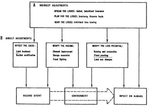
order to modify the impact of a hazard events work through the environment,
cally and socially affect the society. tion of Fig. 2-2 shows this influence outline of an arrow.
event. Hazard and both
physi-The lower por-as the dashed
reserve funds); and (c) bear the losses (individual loss bearing) .
Of significance from the classification
method-ology is the interdependence of adjustments. The
availability of relief (indirect adjustment, spreading the loss) may cause the adoption of land treatment
(direct adjustment, affecting the cause of hazard).
Likewise, the payment of insurance premiums (indirect
adjustment, planning for the losses) may provide the
incentive for adoption of land use (direct adjustment,
modifying the loss potential). Direct adjustments are classified by Arey and
Bauman as:
(i) actions which directly rela~e to the hazard, (affect the cause, e.g. weather modification);
(ii) actions which directly relate to the
envi-ronment, (modify the hazard, e.g. channel improvement
and flood-control reservoirs), and,
(iii) actions which relate to the impact of the hazard, (modify the loss potential, e.g. by warning and evacuation, flood proofing and land-use changes). Indirect adjustments which are also shown in Fig.
2-2 are designed to cope with the aftermath of a flood
event, e.g. (a) spread of the losses (relief, subsi-dized insurance; (b) plan for the losses (insurance,
The authors admit the serious limitations of
their own classification scheme. Such a classification of the theoretical range of adjustments does not draw
the line between the technological and behavioral fac-tors, although admittedly there is an interaction and
interdependence between the two. The authors further
suggest that perhaps there is a more useful dichotomy
for the purpose of policy analysis, if adjustments are distinguished between those that are physical and those which are not.
A
llOIUCT ADJUSTIUTS:II'«<AA liiE LOSSES: Ioiii!, Sdol•n4 lo_,.,.
I'I.AII FOil m I.01SfS: lll•ru<4. lmno ... ,
1m liiE LOSSES: !lldltldul lou )eottoa
8
DIUC T ADJUSTIUTS:AFftCT 1* CAI.'st : IOOIFT liiE IIAZAI;J; IDOIFY 1* lim I'OTElTIAL:
L•d lrollll•l c. ... ,. .... , 1111111 •d Ml<lall .. ll.llltll •odlftcatltl ~
..
...
!!!!' '"'""' -r -IC)Uta L•d ... .._lnI
I"---- -
-
-
-
-
--
-
r-- - ' , ftAZARD EVEn UVIRONIEU---
/ /IIPACT 0. NijiUS
----
~---v
Fig. 2-2 Theoretical Range of Adjustments with Examples from Adjustments to
Flood (Adapted from Arey et al., 1971).
Despite these limitations, the significance of
the classification is that government is confronted with a choicelbecause the development of flood-control policy over the years will be expected to follow a process of expanding the range of actual selections to fit the theoretical range of alternatives underlined by the authors.
2.3 The Present Context of Flood-Control Problems The lresent context should also be presented in the sear~ for a classification. White has expanded on the study of Kates (1970) and has pointed to the
relative characteristics of the three historical re-sponses to flood hazard.
The three responses are:
(a) pre-industrial, modifying human behavior to harmonize with nature rather than to control nature; (b) modern technological or industrial, charac-terized by a limited range of technological actions, inflexible, difficult to change, and high in capital
requirement; and,
(c) comprehensive or post-industrial, which is a response combining features of (a) and (b).
White (1971) has hypothesized that the United States is currently passing the peak of the modern technological type of response to the comprehensive type, as the latter emerges here and elsewhere. This means that a response combining type (a) and (b) will result in a larger range of adjustments, a greater flexibility and a greater variety of capital and o r-ganizational requirements. The classification scheme that is now needed should make allowance for this third response.
2.4 The Classification Used in the Study
The Criteria of Classification. The criteria discussed in previous sections on classification schemes:
are summarized herewith as:
(a) the principles of classification depend on the objectives of the study;
(b) it should be possible to enumerate those
measures that allow man to work with the river.and those measures that work against the river,
(c) it should be possible to classify flood-con
-trol measures on a physical and nonphysical basis, al-lowing for interdependence and harmonization of t
ech-nological and human behavioral adjustments, (d) it should be possible to identify sures which could impose a stress on the and long-term natural equilibrium of the streams, and
those m ea-short-term
system of
(e) it should be possible to identify those which represent direct and those which represent
in-direct adjustments to flood hazards.
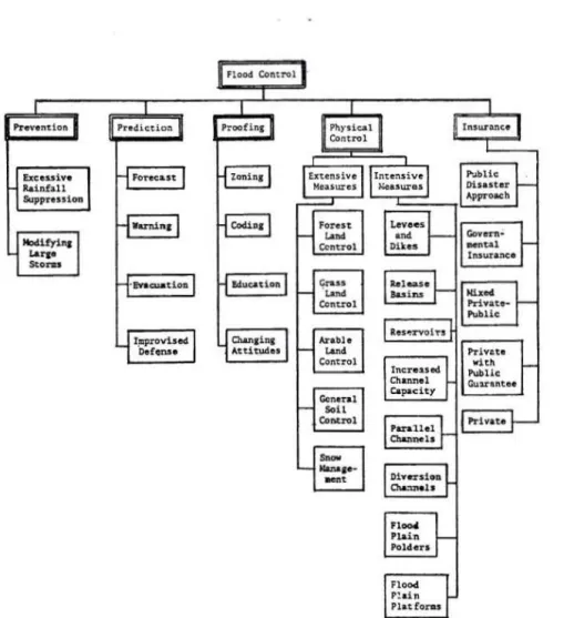
The Classification Used. The classification used in this study is that given by Yevjevich (1973, 1974), since it incorporates a provision for the above crite-ria. The classification is based on five basic groups
of measures: prevention, prediction, proofing, physi-cal control and insurance.
A definitive distinction is made by Yevjevich between flood control and measures. Flood control is defined as all measures, physical or otherwise, that enable the communities living along flood valleys in general and flood plains in particular, to live har-moniously with the natural phenomenon of floods.
:t
I. t
Measures are defined as human actions that help accomplish flood control in this broad sense. These include geophysical, engineering, economical, social, administrative and other actions.
Admittedly it is difficult to come out with the same classification scheme, even from two people
knowledgeable with all aspects of flood control.
Nevertheless, the classification scheme (Fig. 2-3) proposed by Yevjevich is adopted with the follo~ing objectives in mind:
(1) The classification permits the analysis of each measure by developing a proper model of its per-formance, effectiveness, cost, benefit, indirect ef-fects, environmental impacts and various constraints connected with the measure and its model.
(2) The classification allows a check whether all the measures and their combinations have been con-sidered and analyzed in relation to flood-control
planning.
Pr.ven'tlon
/
(3) Th~ classification can be used in conceiving and analyzing a set of well-integrated flood-control measures. (4) subsets with the rated. Such a of alll various
set of measures may be studied as measures feasible in a river basin,
constraints of subsystems
incorpo-Complexities of modern flood-control problems
cannot be best solved by an all-embracing systems
ap-proach, but rather by first breaking the totality of the system down to well defined subsystems, with the
relatively either strong or weak links between the
identified sybsystems. The classification scheme,
therefore, offers an opportunity for development of the topology of flood-control systems, by first help-ing to conceive a particular system in space and time.
The topology means an advanced technique in designing
various alternatives to be analyzed and synthesized.
Fig. 2-3 General Classification of Flood Control Categories, and Individual Measures in Each Category. (Adapted from Yevjevich, 1974).
Chapter 3
ANALYSIS OF FLOOD-CONTROL MEASURES
This chapter deals with the analysis of the five
basic groups of flood-control measures as classified in Chapter 2: prevention, prediction, proofing,
physi-cal control and insurance.
The five basic groups will be analyzed under the
following phases:
(1) A general treatment of each basic group under the subheadings:
(a) general description of flood control measures,
(b) statements of objectives, and
(c) the performance models, and
(2) The results of the relevant model's analysis
as applied to the particular test basin, the Arkansas
Basin.
Of crucial importance to this analysis fact that each basic group of measures either modifies or adjusts to the flood hydrograph. changes and modifications 1;ill be discussed
basic group in its sequence.
is the
alters,
These
in each
The details of the analysis of each basic group
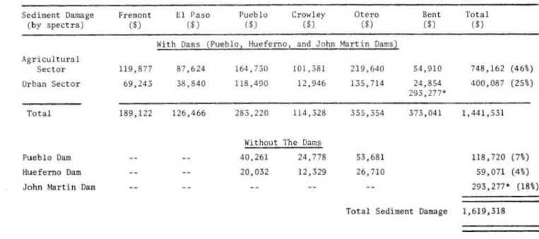
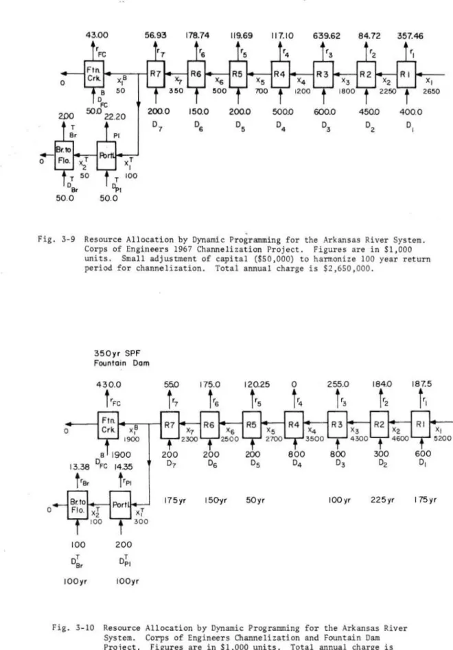
~o.•ill be carried out in relation to the data available from the test region, the Arkansas River Basin and its major tributaries above the John ~lartin Dam. Reports (1968, 1970) of the District Engineer, U.S. Army Corps
of Engineers, Albuquerque, New ~texico, provide these
data.
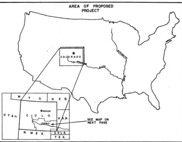
Figures 3-1 and 3-2 indicate the geographical location and the local extent of the proposed projects
respectively.
The objective of the analysis of the five basic
groups in relation to the test basin is to evaluate
the alternative strategy that could have been over-looked by previous project proposals. The U.S. Army
Chief of Engineers when testifying in 1973 recognized the need for a broad-range alternative of structural and nonstructural measures, although the Corps
Dis-trict proposals (1968, 1970) have concentrated merely
on structural measures with their subsequent environ -mental objections, and suspension.
3.1 Prevention ~feasures
(a) General Description. The preventive measure is broadly divided into t~o.·o: (a) meteorological pre-ventive measures and (b) prevention of breaches of
artificial water-impoundment structure such as levees
and dams.
The goal of the meteorological preventive measure
is to flatten out the resulting flood hydrograph from (a) excessive local rainfall or (b) large storm
sys-tems such as hurricanes and typhoons. The goal in
prevention of breaches is to reduce the hazard· of
po-tential catastrophe such as a landslide or earthquake
near a dam, resulting in a sudden release of a flood
wave of considerable destructive power.
To flatten the flash flood hydrograph of e xces-sive rainfall, such hydrograph exhibiting the
charac-teristic of small volume but of rapid speed, which
leads to its potential destructiveness, the goal is
either to decrease the exceptionally high-frequency
precipitation intensities or to divert the
precipita-tion away from some initial areas.
To flatten the flood hydrograph of large storms such as hurricane and cyclone, which cause the most damage due to their relatively high wind velocity and
subsequent wide-spread areal flooding, the goal in
large storm modification is to decrease the
exception-ally high precipitation of flood preducing magnitude by retaining a controlled intensity of long duration
over larger areas. The goal of this prevention is
aimed therefore at the very genesis of causes of storms ~hich lead to subsequent flooding. It is aimed
at storm manipulation and success in such an attempt
may not be achieved for sometime in the future,
be-cause even the most potent forces controlled by man
are practically negligible compared to nature.
The prevention of floods caused by snow melt can
be done by snow channeling in large depression or by changing the albedo but since the areal snow coverage
is so extensive that pure economic considerations alone limit its potential application.
The prevention of floods caused by breaches of impounded water can be improved by periodic inspection and review of all such structures. Early detection of
potential danger from landslides and earthquakes caus-ing dams, levees or reservoirs to collapse could lead
to timely evacuation, arrangement of public
protec-tion, and timely remedial action.
(b) Statements of Objectives.
(1) Excessive local rainfall suppression. It is relatively easy to apply an optimization proce -dure using economic efficiency criterion in
maximiza-tion of net benefit to excessive rainfall suppression in a 1 imi ted geographic area. The net benefit must be
positive and exceed all other net returns which can be obtained by alternative measures. (Gutmanis, et al., 1966).
where
max. NBRS (3-1)
CRS = C Se. +
C
Eq. + C Ad. (3- 2)NBRS is the expected annual net benefit of
ex-cessive rainfall suppression.
BRS'CRS is the expected annual benefit and cost of the rainfall suppression.
~R
is the expected annual floodtion, and
damage
reduc-CSe.'cEq.' and CAd. are the expected annual costs
of seeding; of equipment and of administer -ing the program respectively.
AREA OF PROPOSED PROJECT
H.
Fig. 3-1 Area of Proposed Project.
r_,...
I
!
I
I
(.,
Ic---1
.,
j
'
) ' - • - · Ic~
,
m
~---N-<
'
'\--
- - - ---r·J
\
.
\
!
IAREA
Of PROPOSED PROJECT'
,..-'"--(_
1
I
'4 . I - - - II
I
~~>--.
1
i
II
I
"_1
_
.
..
...
L(GfiiDI
- -
~--- -- --•ntATIOtl •.-en JM.A .,., ... / - MCACIFIIIIIIOf'IOICD...._CT,
I
,
L--
-
-
~--
-.-.L
__
_j
/
I
I
I
I
L ______ ._, ____
_j
(2) Excessive storm modification. Storm
modification is expected to create external
disecono-mies causing huge social costs. By decreasing the
rainfall intens~t~es over a larger area, an area in
which tourism predominates and which favors no
precip-itation may be affected more than an agricultural area
which requires the rainfall.
The objective is to maximize the expected annual
net benefit of storm modification, NBSM' i.e.,
(3-3)
where BSM' CSM are the expected annual benefit and
cost respectively of the storm modification
program.
where
(3-4)
CSM CSMT + CE q. + C Ad. + C con. (3-5)
XDR' ~· and XED are respectively the expected
annual benefits from flood damage reduction;
potential uses of excess water from the
storms, and the resulting social cost in
local external diseconomy and,
CSMT' CEq. and CAd. are respectively the expected
annual costs of storm modification
technol-ogy; of equipment and of administering the
storm modification program. Vital to this
program is the cost of control C con. in
or-der to discriminate with and without storm
modification results.
(3) Breaches of artifical impoundment of
water. If the life of the structure such as a levee
~dam is a relatively long one, the expected value
approach ~s again valid to estimate risks and un
cer-tain~ies associated with breaches.
The objective is to maximize the expected annual
net benefit of preventing breaches of artificial
im-poundment of water, NBBI i.e. ,
(3-6)
where,
where BBI'
c
81 are the expected annual benefit and cost respectively of the prevention program.
(3-7)
~r' XLL' XED' XEA and Xcom. are respectively
the expected annual benefits of preventing
flood damage, subsequent loss of life, ex
-ternal diseconomy, emergency aid, and
com-pensation.
CRA' CEv.' CRe.' CSec. are respectively the
ex-pected annual costs of remedial action,
emergency evacuation, subsequent rehabili
ta-tion and public security prQtection.
"
(c) The Performance Models. The performance
model is usually an economic optimization model as
previously outlined in the section on statement of
objective. Incorporated or imbedded in this overall economic mode·l is the technological submodel which
deals with the particular problem at hand, e.g., ex
-cessive local rainfall suppression, large storm m odi-fication, regional snow melt or artificial breaches. Even in one subclassification, excessive rainfall suppression, the technological submodels vary in com-plexities in accordance to the varieties of local
weather processes. Cold cloud seeding by iodide or dry
ice is different, for example, from warm cloud seeding by sodium chloride. The natural cloud processes also
vary according to geographical location, temperate or
tropical regions.
There are technological submodels available which
are related to potential breaches of levees. (Bogardi
I, 1968, 1971, 1972). Four modes of levee failures
have been studied; overtopping of the crest by
flood-ing; boils and hydraulic soil failure in the substra-tum; loss of slope-stability and sliding due to
seep-age and erosion caused by wave action.
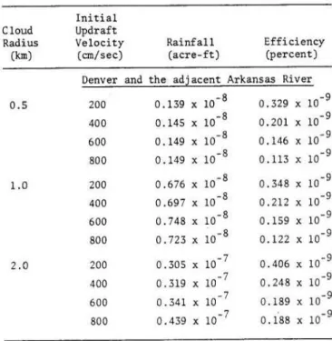
The Submodel for the Test Area. The submodel
chosen for the Arkansas Basin is related to the
air-mass thunderstorms due to convective heating and
oro-graphic lifting. The latter type is responsible for
precipitation in the form of intense storms, which
cause flash floods of short duration and small volume
but of damaging intensities. Colorado Springs and
Pueblo, for instance, have peak thunderstorm activity in July, with an average between 13 and 17
thunder-storm days, respectively. The attention here is an
evaluation of whether a potential economic benefit
exists in seeding war~ clouds of the convective type
(isolated cumulus clouds) in order to diffuse them or
to divert such potential rainfall away from the land
producing floods along the most important urbanized
and agricultural floodplains.
Durham (1973) has investigated rainfall
augmenta-tion from warm cumulus clouds by sodium chloride
seed-ing. This study was interested, however, in evaluating
the potential benefit of the Durham's model in
rela-tion to flash flood suppression. The choice of Durham's
climatological model is based on the fact that the study area covers Denver, which is the next largest
basin closest to the Arkansas River Basin.
The Durham (1973) performance submodel is a one-dimensional steady state cumulus cloud model. It
con-siders the lateral entrainment process, droplet growth
by condensation and coalescence and the development
and fallout of precipitation. It covers the standard
thermodynamic and dynamic processes in isolated warm
cumuli.
The performance parameters are divided broadly into two groups:
(i) the initial conditions at the cloud base at
the time of seeding such as updraft velocity, updraft
radius and cloud droplet spectra, and
(ii) a vertical profile of pressure, temper
a-ture, relative humidity and horizontal wind speed.
(d) The Results of the Model's Analysis
asAp-plied to the Particular Test Basin, The Arkansas River
Basin. The results of the writer's analysis show that
although precipitation could be induced through
seed-ing of isolated warm cumulus clouds, the efficiency of
this case is defined as the ratio of precipitated water to condensed water available in the cloud.
Durham's analysis is optimistic because his re -sults show precipitation induced in the range of 7.4
to 137.0 acre-ft of rainfall over an area of 2.72 to
8.17 square miles respectively, with a corresponding ef~iciency range for Denver from 1.29 to 2.00 percent.
These ranges correspond to a rainfall intensity of
0.05 to 0.3 inches per acre. The writer believes that
Durham's results do not reflect the average climato-logical conditions for seeding, but rather the optimal
climatological situation. Nevertheless, the efficiency
of the precipitation mechanism induced by seeding is still extremely low, even under those optimal condi-tions.
The writer has tested the above hypothesis with
average radiosonde soundings available for both Denver,
Colorado and Fort Worth, Texas. Sensitivity analysis is carried out with a systematic variation of initial updraft velocity at the cloud base at the time of
seeding. The results confirm the hypothesis that
seeding of warm cumulus clouds over the Arkansas River Basin will not be of economic benefit in flash flood
suppression. The Fort Worth vertical radiosonde
pro-file is included to cover the range of average clima-tological conditions expected to prevail over the
Arkansas River Basin (Tables 3-1 and 3-2).
Cloud Radius (km) 0.5 1.0 2.0
TABLE 3-1 AVERAGE DAILY ~~DEL. ASSESSED SEEDING RESULTS
Initial Updraft Velocity (em/sec) Rainfall (acre-ft) Efficiency (percent) Denver and the adjacent Arkansas River
200 0.139 X 10⁻⁸ 0.329 X 10- 9 400 0.145 X 10⁻⁸ 0.201 X 10⁻⁹ 600 0.149 X 10⁻⁸ 0.146 X 10⁻⁹ 800 0.149 X 10⁻⁸ 0.113 X 10⁻⁹ 200 0.676 X 10- 8 0.348 X 10- 9 400 0.697 X 10⁻⁸ 0.212 X 10- 9 600 0. 748 X 10- 8 0.159 X 10- 9 800 0. 723 X ~0-8 0.122 X 10⁻⁹ 200 0.305 X 10⁻⁷ 0.406 X 10⁻⁹ 400 0.319 X 10- 7 0.248 X 10⁻⁹ 600 0.341 X 10- 7 0.189 X 10⁻⁹ 800 0.439 X 10⁻⁷ 0.188 X 10⁻⁹ 3.2 Prediction Measures
(a) General Description. The prediction measures include flood forecasting, flood warning, flood fight
-ing defense and evacuation of people, livestock and goods.
The goal of the prediction measure is to reduce the flood hazard in the river basin by accurately
pre-dicting the expected magnitude and time of arrival of
floods, since floods represent a rapidly evolving di-saster. Hence there is no alteration or adjustment
Cloud Radius (km) 0.5 1.0 2.0 r'
TABLE 3-2 AVERAGE DAILY MODEL. ASSESSED SEEDING RESULTS
Initial Updraft Velocity (em/sec) Rainfall (acre- ft)
Fort Worth Radiosonde Vertical
Denver's Droplet Spectra 200 0.099 X 10⁻⁸ 400 0.102 X 10⁻⁸ 600 0.107 X 10•8 800 0.113 X 10⁻⁸ 200 0.726 X 10·8 400 0.737 X 10⁻⁸ 600 0.748 X 10⁻⁸ 800 0.763 X 10⁻⁸ 200 0.303 X 10⁻⁷ 400 0.326 X 10⁻⁷ 600 0.346 X 10⁻⁷ 800 0.367 X 10⁻⁷ Efficiency (percent) Profile with 0.705 X 10⁻⁹ 0.264 X 10- 9 0.238 X 10⁻⁹ 0.173 X 10⁻⁹ 0.498 X 10- 9 0.281 X 10⁻⁹ 0.196 X 10⁻⁹ 0.150 X 10⁻⁹ 0.464 X 10⁻⁹ 0.269 X 10⁻⁹ 0.195 X 10- 9 0.156 X 10_g
made of the flood hydrograph, only its genesis; its peak and stage and its expected time of arrival is made in the forecast and warning.
Without prediction, there are basic risks
associ-ated with the state and occupancy of the river f
lood-plains. With prediction these basic risks are modified
by altering the conditions, state and occupancy of the
floodplains before the flood. The adjustment is made
by evacuation or temporary abandoning of the flood
-plain areas, with people moving to higher ground, and
doing whatever is possible to minimize damage to the
properties which cannot be moved. Flood fighting
operations may become necessary at some sections of
the river system, when the degree of natural protec-tion is lower than the actual flood level.
Two basic questions have been raised related to flood protection: (Yevjevich, 1964):
(1) How feasible are the forecasts and how far
in advance can they be made?
(2) What is the economic worth of these forecasts? The feasibility of the forecasts is limited to short-range and medium-range hydrologic forecasts
(Lambor, 1967), which are characterized quantitatively,
based on the physical course of phenomena and on
pre-cipitation and runoff measurements.
On major tributaries, flood warnings can be
is-sued hours to days in advance of the flood wave
trav-eling down the major tributaries. ~1ain stem river forecasts can be issued as far as several days or even weeks in advance. In general, the time lapse between rainfall or snowmelt and the rise in river height i n-creases with the size of the river.
Besides the forecast time, the flood warning time
tw, is one of the most important parameters in flood-plain operation (if the floodplain is regarded as an
elastic reservoir), and as such the flood warning time
should be extended as far as possible to secure the
various potential benefits such as evacuating low
lying area~; moving pe:sonal property, mobile equ ip-ment and l1vestock to h1gher ground; alerting
emergen-cy and relief organizations to care for refugees; to
prepare for the inevitable subsequent health hazards
caused by floods and even harvesting valuable crops in advance of the destructive flood.
The weakest link is not in either the speed of collection and analysis of meteorological and hydro
-logical data or the speed of transmission of the
ensu-ing forecast or the time of travel of the flood wave
but the speed of disseminating the forecast and warn-ing to all the economic activities endangered in the
floodplains (Bugliarello, et al., 1963).
The economic worth of flood forecasts is related
to the level of economic development in the river
basin, for which flood forecasts are needed. The re -quirements and economy of the area dictate the rela
-tive economic worth of flood forecasts (Kohler, M.A.
1967). Since economic losses in the United States due
to flooding have shown a more persistent upward trend than lives lost, (White, 1973), the economic worth of flood forecasts is found to be equivalent to about 5 percent of the total expected annual economic losses sustained by flood damages. Day, (1970), Grayman and Eagleson (1973) and White (1973) have reportedly quoted the range between 2 to 5 percent of total
eco-nomic losses that can be prevented through prediction
and warning systems.
(b) Statements of Objectives. The objectives of
the analysis depend upon the selection of the appro-priate kind of flood forecast which depends upon the
particular flood type. Four principal flood types have been identified and classified for temperate region,
(Lambor, Warsaw and Australia, 1967),
(1) Rainfall floods, (type 0);
(2) Snowmelt floods, (type R);
(3) Storm floods on the sea coast (type \ ) ; and {4) Winter floods (type z).
The most violent floods are identified as type 0, the rainfall floods, in temperate countries. Type 0 is further subdivided into:
(1) Sho>t thermal storm flood, (type On); (2) Frontal rainfall flood, (type Of); and (3) Frontal rainfall flood, intensified by ground orography, (type Or).
Flood types appeared classified and identified (Chin, 1967).
hitherto not to have been for the tropical regions Of all the rainfall floods, flash floods of type On are the most difficult to predict because of their localized nature and speed of travel. Both hydrologic forecasts of the short and medium-range give too short
a notice of the flash flood. Though radar could be used to predict the specific areas where excessive rains will fall, radar interference is present where there are mountains in the area, Philip, et al., 1972).
However, prediction prospects for the other two types of rainfall floods, of and or of the frontal character are much more favorable. In fact both mete -orological medium-range forecasting Fm, and
hydrolog-ic short and medium-range forecasting, Ph and Fh can be used conjunctively, (Lambor, J., 1967).
The objective is to maximize the annual expected net benefit of flood prediction NB p' i .e.'
max NB
=
B - Cp p p (3-9)
where Bp' Cp are respectively the expected annual
benefit and cost· of the prediction measure.
(c) The Performance Models. The performance model is the overall economic model of maximizing net benefit, in which is embedded the climatic-hydrologic
submodels. Once the particular submodel is chosen for
the particular flood type, such a submodel is
incorpo-rated into computer simulation models to simulate the
impact of the areal and time distribution of rainfall, r~off and subsequent level of flooding at the given
t1me and place and its estimated effects on the
re-sources situated at the various locations identified. The flood warning information is the expected flood
stage, its flood peak and its expected time of arrival
of the flood. Hydrologic conceptual models for basin
runoff and flood prediction are available such as the
Sta?ford Watershed Mo~el, SSARR model of the Corps of
Eng7neers.and the Nat1onal Weather Service, the
Hydro-loglc Eng1neering Center 1 model, and others.
The Submodel of the Test Area. The climatic-hy-drologic submodel chosen for the test area is the H. I. T. meso-scale weather submodel for the frontal type floods (type Of). The prediction is for slow floods of the frontal weather type, caused by conver-gence of cold artie air from the north with the warm moist Gulf air from the south. Prediction for this type of flood has been found to be promising.
The M. I . T. sub model is due to Grayman and Eag! eson
(~973) and in applying to the test region, the assump -tlon is made that the parameters of the meso-scale
weather system of the New England region is applicable
to the Arkansas Bas in in Co lorado.
The economic model involves pected annual net benefit of the i.e., max. ~B z B - C , where
p p p
have been defined previously. Nj
maximizing the ex-prediction measure, the symbols Bp' Cp
B
m F(. l,J ') k
L
=l PC i,j,k,m)( 3-10) where Bm
=
the net benefits to floodplain occupants; re=
the fraction of occupants that respond to a flood warning; N r =the number of river reaches· , N. J • the number of discrete levels in reach J·. F = the• (i ,j) probability of a flood of level i
j in any year; P( . . l,J, k ,m ) =the
occurring in reach
probability of an