AN ACTIVE SEISMIC RECONNAISSANCE SURVEY OF THE MOUNT PRINCETON AREA
CHAFFEE COUNTY, COLORADO
by
ProQuest Number: 10782043
All rights reserved INFORMATION TO ALL USERS
The qu ality of this repro d u ctio n is d e p e n d e n t upon the q u ality of the copy subm itted. In the unlikely e v e n t that the a u th o r did not send a c o m p le te m anuscript and there are missing pages, these will be note d . Also, if m aterial had to be rem oved,
a n o te will in d ica te the deletion.
uest
ProQuest 10782043
Published by ProQuest LLC(2018). C op yrig ht of the Dissertation is held by the Author.
All rights reserved.
This work is protected against unauthorized copying under Title 17, United States C o d e M icroform Edition © ProQuest LLC.
ProQuest LLC.
789 East Eisenhower Parkway P.O. Box 1346
A t h e s i s s u b m i t t e d to th e F ac u lt y a nd t h e Board of T r u s t e e s of th e Color ado School of M in es in p a r t ia l fulfi ll me nt of t h e r e q u i r e m ent s for the d e g r e e of M a s t e r of S c i e n c e in G e o p h y s i c s .
Signed:
■
i/s *
u>./am e s Scott Crompton G o l d e n , Color ado Dat e :
Y
, 1976 Approved: P hillip R. Romig, Jr. T h e s i s Advisor Ge o rg e V. Keller H e a d of De p ar tm en t G o l d e n , C olo ra do Date: # 1976T-1842
ABSTRACT
An a c t i v e s e i s m i c - r e c o n n a i s s a n c e s u rv ey w a s c o n d u c t e d of t h e Mount. Prince ton a r e a , n e a r Buena V i s ta , Colorado in t h e fa ll of 1975. The s u rv e y w a s d e s i g n e d to monitor l a r g e mining b l a s t s from nea rb y mining o p e r a t i o n s at Climax an d Mon arc h P a s s , Color ado and Q u e s t a , New M e x ic o an d to i n t e r p r e t t h e s e o b s e r v a t i o n s u s i n g r e f r a c t i o n t e c h n i q u e s . The r e s u l t s i n d i c a t e t h e im p or ta nc e of e x am in in g a p p a r e n t a z i muths of en er gy pa th s into a l o c a l array an d comparing t h e s e az i m u t h s w it h t h e known s o u r c e - r e c e i v e r g e o m e t r y . C o n c l u s i o n s from t h i s s u r v ey s u g g e s t the e x i s t e n c e of l a t e r a l r e f r a c t i o n s from boundary f e a t u r e s of t h e up per A rk ans as Valley g r a b e n , c o r r e l a t i n g wi th t h e e x t e n s i o n of t he Rio Gran de Rift a s far north a s L e a d v i l l e , and a f a s t time r e s i d u a l due to a pr o b a b le normal f a u l t in t h e s u b s u r f a c e of Chalk C r e e k , s o u th of Mount P r in c e to n .
This s u rv ey d e m o n s t r a t e s t h a t a mo dified v e r s i o n of t h e c r u s t a l r e f r a c t i o n t e c h n i q u e c a n be a v er y c o s t - e f f e c t i v e m ean s of s u r v e y i n g th e v e l o c i t y and s tr u c t u r a l c h a r a c t e r of a la r g e p r o j e c t a r e a .
TABLE OF CONTENTS Page A b s t r a c t ... ii List of Fi gures an d T a b l e s ... iv I n t r o d u c t i o n ... 1 A c k n o w l e d g m e n t s ... 3 Regional G eo l o g i c S e t t i n g ... 4 G e o l o g i c H i s t o r y ... 8 Scope of I n v e s t i g a t i o n an d O p e r a t i o n s ... 11 E q u i p m e n t ... 17 O b s e r v a t i o n s ... 24 I n t e r p r e t a t i o n ... ... 41 E v a lu a ti o n of Active S e i s m i c T e c h n i q u e ... 52 C o n c l u s i o n s ... 56 R e c o m m e n d a t i o n s ... 57 B i b l i o g r a p h y ... ' ... \... 58 i i i
T-1842
LIST OF FIGURES AND TABLES
FIGURES Page
1 L o c at ion M a p ... 5
2 G e o l o g i c Cr os s S e c t i o n ... 7
3 S tat io n Loca tio n M a p . 15
4 S c h e m a t i c Diagram of E q u i p m e n t ... 17 5 Fr equ enc y C h a r a c t e r i s t i c s ... 19 6 WWVB C o d e ... 20 7 T e l e s e i s m USSR 2 9 4 - 1 2 3 2 ... 22 8 Loc al Event 294-2051 ... 22 9 Climax Event 295-2113 ... 23
10 Ref ra cti on Profile T e l e s e i s m U S S R ... 28
11 Refra cti on Profile T e l e s e i s m Kuril Is * ... 2 8 12 Ref raction Profile T e l e s e i s m M e x i c o ... 29
13 Ref raction Profile Elkh ea d M t n s ... 31
14 Refr action Pr ofiles Re gi o na l W N W ... 3 2 15 Refr actio n Profile Cli ma x Ref racted Azimuth . . . . 34
16 Ref ra cti on Profile Climax G e o g r a p h i c Azimuth. . . 35
17 Ref ra cti on Profile M ona rch P a s s ... 3 7 18 Amplitude v e r s u s D i s t a n c e c u r v e ... 39
19 Three S ta t i o n Apparent V elo cit y V e c t o r ... 45
20 La te ra l R e f r a c t i o n s , Buena V i s t a ... 46
21 Arrival Time R e s i d u a l D a t a ... 49
2 2 Velocity an d Struc tur e M o d e l s ... 49
TABLES Page 1 S t at io n C o o r d i n a t e s . . ... 16 2 Rec orded E v e n t s ... 25 3 L oc al E v e n t s ... 40 v
T-1842 1
INTRODUCTION
The s e i s m i c r e f r a c t i o n t e c h n i q u e has b e e n u s e d for many y e a r s to o b t a i n s u b s u r f a c e v e l o c i t y an d s tr u c t u r e i n fo rm at io n . This t e c h nique wa s e x p l o i t e d e x t e n s i v e l y in t h e 1960's a s par t of th e VELA Uniform program of c r u s t a l s t u d i e s in th e w e s t e r n Un i t ed S t a t e s and in t h e d e s i g n of t h e l a r g e a p e r t u r e s e i s m i c array (LASA) in e a s t e r n M o n t a n a . Wit h t h e a v a i l a b i l i t y of n u c l e a r t e s t e x p l o s i o n s an d l a r g e mining b l a s t s , la rg e a r e a s w e r e s u r v e y e d u s i n g e q u i p m e n t d e s i g n e d s p e c i f i c a l l y for t h i s p u r p o s e (Warrick et a l , 1961; J a c k s o n and P a k i s e r , 1965; P a k i s e r , 1963; J a c k s o n , Ste war t an d P a k i s e r , 1963; C a p o n , 1974). B e c a u s e many di ff er en t g e o p h y s i c a l and g e o l o g i c m e a s u r e m e n t s can be m a d e , e x p l o r a t i o n d e c i s i o n s m u s t be made b a s e d on t h e s t r e n g t h s an d w e a k n e s s e s of e a c h t e c h n i q u e . The very r e a l l i m i t a t i o n s of e c o n o m i c s , a v a i l a b l e e q u i p m e n t a n d time r e s t r i c t t h e s e d e c i s i o n s e v e n fu r t h e r . Survey metho ds w h i c h c a n i n v e s t i g a t e a l a r g e p r o s p e c t a r e a and d e l i n e a t e l o c a l f e a t u r e s for further s tu d y provide a n a c c e p t a b l e comp ro mis e b e t w e e n t h e c o n f l i c t i n g d e m a n d s of d a t a a c q u i s i t i o n an d c o s t . One s u c h sur vey m e t h o d , t h e a c t i v e s e i s m i c r e c o n n a i s s a n c e t e c h n i q u e , i s d i s c u s s e d in t h is t h e s i s .
MOUNT PRINCETON SURVEY
Between O ct ob er 20th a n d O c t o b e r 24t h, 1975 , an a c t i v e s e i s m i c r e c o n n a i s s a n c e s u rv ey w a s c o n d u c t e d of th e Mount Prince ton a r e a , n e a r Buena V i s t a , C o lo r ad o. This p r o j e c t w a s d e s i g n e d a s a f ie ld
e x pe r im en t t o t e s t a modi fie d v e r s i o n of the c r u s t a l r e f r a c t i o n program u s e d in t h e VELA Uniform s t u d i e s by r ec o rd in g mining s h o t s from s e v e r a l l o c a t i o n s an d i n t e r p r e t i n g a r ri v a l ti m es a s a r e fr a c t i o n p r o f i l e . The i n d e p e n d e n t o p e r a t i o n s of th e m ic r o e a r t h q u a k e eq u i p m en t u s e d a l l o w e d 2 4 - h o u r co n t i n u o u s monitoring a nd good a r e a l c o v e r a g e over a l a r g e p r o je c t a r e a . Real time i n t e r p r e t a t i o n of d a t a a l l o w e d for r e l o c a t i o n of s t a t i o n s away from problem l o c a t i o n s t hu s improving the d a t a q u a l i t y in th e f i e l d .
The fo llowin g i s a l i s t of t h e c o n c l u s i o n s from t h i s study:
1) The a c t i v e s e i s m i c r e c o n n a i s s a n c e t e c h n i q u e s u c c e e d e d in s u r v e y i n g t h e l a r g e Mount P r in c e to n p r o je c t a r e a by d e l i n e a t i n g the r e g i o n a l s tr u c t u r e and by s in g l i n g out s p e c i f i c l o c a l t a r g e t s for furth er i n v e s t i g a t i o n .
2) I n te r p r e t a t i o n of a p p a r e n t - a z i m u t h d a t a from s e v e r a l s o u r c e s i n d i c a t e s t h a t l a t e r a l r e f r a c t i o n s o c c u r from bo th the e a s t and w e s t s i d e of t h e up per A r k a n sa s River Vall ey.
3) W it h i n th e p r o j e c t a r e a , a f a s t time r e s i d u a l e x i s t s , due to a p r o b a b l e normal f a u l t in t h e s u b s u r f a c e , c o r r e s p o n d i n g t o t h e Chalk C re ek d r a i n a g e f e a t u r e .
T-1842 3
ACKNOWLE DGE ME NTS
I t h a n k t h e members of my c o m m i t t e e , Dr. David Butler, Dr. Eric E n g d a ll , and Dr. F. Richard Y e a t t s , and e s p e c i a l l y my a d v i s o r , Dr. Ph illip Romig for t h e i r he lp and s u p p o r t . This r e s e a r c h w a s m ade p o s s i b l e through a c o n t r a c t b e t w e e n AMAX Exploration an d M i c r o G e o - p h y s i c s Cor p or atio n t o c o n d u c t t h e a c t i v e s e i s m i c e x p e r i m e n t at Mount P r i n c e t o n . I a l s o a p p r e c i a t e t h e u s e of e q u i p m e n t , fu nding a n d v a l u a b l e a d v i c e from Art L a n g e , AMAX Exploration an d Dr. Butler and Paul Larry Brown of M GC. S p e c i a l t h a n k s to Ed Torrgeson of AMAX Exp loration a nd Cal Brown a t t h e Climax m i n e , who w e r e m o s t r e s p o n s i v e to r e q u e s t s for information c o n c e r n i n g t i m e s of b l a s t i n g at Climax a n d Q u e s t a , New M e x i c o .
REGIONAL GEOLOGIC SETTING
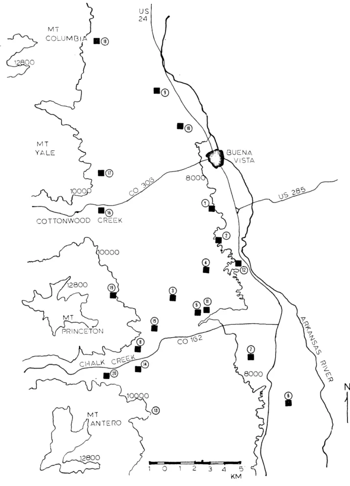
The Mount Pr in ce to n p r o s p e c t ar ea is l o c a t e d in s o u t h - c e n t r a l C o lo ra do , ap p r o x i m a te ly 150 km s o u t h w e s t of Golden (see figure X, l o c a t i o n map) . T o p o g r a p h i c a l l y , the a r e a l i e s on t h e bor der of the S a w a t c h Range and t h e up p er A r k an sa s River V a l l e y , b e t w e e n Buena Vista an d Salid a in Chaff ee Cou n ty .
The u p p e r Ar k an sa s River V al le y , e x t e n d i n g north from Salida to L e a d v i l l e , is b e l i e v e d to be a c o n t in u a t i o n of the Rio Gr and e Rift Zone (Knepper, 19 74). The rift f e a t u r e , w h i c h c a n be t r a c e d from nor the rn M ex ico through c e n t r a l New M ex ico into c e n t r a l C o l o r a d o , a p p r o x i m a te ly 960 km, h a s formed s i n c e m id -T e r ti a r y time by the r e l a t i v e w e s t w a r d movement of the Colorado P l a t e a u p l a t e w i t h r e s p e c t to t h e Great P la in s p l a t e . This c r e a t e d a z o n e of c r u s t a l e x t e n s i o n s u p e r i m p o s e d on t h e pr evi ou s t e c t o n i c f o u n d a t io n (G ros e, 1974). In more r e c e n t g e o l o g i c h i s t o r y , th e up l i ft of t h e Sangre de
Cr ist o Range c a u s e d a s e p a r a t i o n of the rift z o n e in C o lo r a d o . The t i l t e d fa u l t bl o ck a t Poncha P a s s now d i v i d e s the upp er A rk ans as Valley from t h e San Luis Valley (Knepper, 1974).
The up p e r A r ka ns as Valley is a nar row , n o r t h - t r e n d i n g , d o w n - dro pp ed trough bou n de d by s t e e p l y dip p in g norma l f a u l t s . This s t r u c tura l v a l l e y is o ou n d ed on th e w e s t by t h e P r e - C a m b r i a n ig n e o u s a n d meta mo rph ic cor e s e q u e n c e of th e Sa w at ch a n t i c l i n e . The p r e s e n t t o p o g r a p h i c e x p r e s s i o n of t h e a n t i c l i n e is t h e S a w a tc h Range, w h i c h
T - 1 8 ^ 2 s w
<
PC CQ W Si 0 a H s o SYSNYM 0 ro > 0 d 0 d w cr> 0 G G G d d < r* C6 •U ^ x: u u 0 G -P •ro 0 d O CX 2 g a d a, ^ co >i -p 0 4-J rH *H rH PC d 0 C -P > 0 s 0 G G ■H d d P G P b0 ZD n0 0 0
d -rH d oq ex cq G G d d a ex 0 0 -P -P d 0 rH •H ex G x: riX 0 g u 0 G ^ Cr> 0 G ‘ G d g G > 0 4-) d ex d d -H 0 TJ £ P ex CX ex 0 0 •P 0 G <-; rH r 1 ■P 0 £ G 0 *0 4-) G 4-> tX» > G rd P 0 •H G G 0 -H 0 G SCi—1 d 0 p CQ Cm £ P zn Q O'* o rH CM ro ^ uo ID rH rH rH rH rH rH rH w CX D O H Cm a 2 p o H § u o p rH i n ro in < SJ o o HVJ,n N E W M E X I C Oi n c l u d e s many of t h e h i g h e s t p e a k s in t h e Sou th ern Rocky M o u n t a i n s . Mount P r in c e t o n , e l e v a t i o n 4 , 3 2 8 m (14,197 feet) ab o v e s e a l e v e l , is one of th e l a r g e s t of a s e r i e s of Te rtiary i n t r u s i v e s w h i c h cut t h e Pre-
Cambrian r o c k s in the s o u th e r n par t of t h e S a w a t c h Ra n ge . The bou nd ary fa u l t on t h e w e s t e r n ed g e of th e troug h is g e n e r a l l y a s i m p l e , narrow fa u l t z o n e . E s t i m a te s of t h e d i s p l a c e m e n t on t h i s f a u l t , b a s e d on th e e x i s t i n g t o p o g r a p h y a n d t h e a s s u m p t i o n of a l a t e Eoc ene e r o s i o n a l s u r f a c e , r a n g e from 1500 to 3000 m. The e a s t s i d e of t h e trough is b ou nd ed by th e s o u th e r n e x t e n s i o n of t h e M o s q u i t o - T e n Mile R an g e . In t h e p r o s p e c t a r e a , t h i s r an g e d e g e n e r a t e s into a r ug g ed h ig h l a n d of p r e d o m in a te ly P r e - C a m b r i a n ig n e o u s an d m et am o rp h ic r o c k s o v e r l a i n by up pe r Tertiary v o l c a n i c flows an d p y r o c l a s t i c r o c k s . The e a s t e r n bo un dar y of t h e tr o u g h is c h a r a c t e r i z e d by a more c o m p le x s y s t e m of p a r a l l e l normal f a u l t s w it h t h e major d i s p l a c e m e n t a t t r i b u t e d t o a fa u l t bu rie d u n d e r n e a t h Tertiary a n d Q u a t e r nary s e d i m e n t s a p p r o x i m a te ly p a r a l l e l i n g t h e p r e s e n t c o u r s e of t h e Ar ka ns as River d r a i n a g e (Limbach, 1975; Knepper, 1974) (see figure _2, g e o l o g i c c r o s s s e c t i o n ) .
T— lc&2 WEST MOUNT PRINCETO INTRUSIVE core of the SAWATCH ANTICLINE COLORADO PLATEAU PLATE FIGURE 2 ARKANSAS RIVER ALLUVIAL - - - FILL EAST MOSQUITO-TEN MtLE HIGHLANDS (ARKANSAS HILLS) + + + + + + + + + + + + + + + +
RIO GRANDE RIFT GREAT PLAINS PLATE GENERALIZED GEOLOGIC CROSS SECTION
UPPER ARKANSAS VALLEY
The following section presents a brief geologic history of the prospect area with particular emphasis on the structural and petrographic features which could have a significant seismic expression and therefore
present keys to understanding the parameters of an active seismic investigation in this locale.
GEOLOGIC HISTORY
The P r e - C a m b r i a n h is to r y of t h e a r e a is s e p a r a t e d into four s t a g e s (Knepper, 19 74). F i r s t , c l a s t i c s e d i m e n t s w it h minor am ou nt s of c a r b o n a t e m a t e r ia l w er e d e p o s i t e d . Later t h e s e r o c k s w e r e f o ld e d a nd r e c r y s t a l l i z e d . At the s am e t i m e , a p p r o x i m a te ly 1.7 b i l l i o n y e a r s a g o , minor b a s a l t flows w er e e x t r u d e d . The th i r d s t a g e is c h a r a c t e r i z e d by t h e i n t r u s i o n of a fine g r a i n e d s u i t e of r o c k s ran gi n g in c o m p o s i t i o n from g r a n i te to q uar tz m o n z o n i t e . F i n a l l y , r e g i o n a l uplift and e r o s i o n b ro ug ht a c l o s e to the s e r i e s of e v e n t s w h i c h pr od u ce d t h e rig id b a s e ment c o m p l e x .
In e a r l y to middle P a l e o z o i c t i m e , t h e a r e a w a s par t of a s t r u c t u r a l low in the T r a n s - C o n t i n e n t a l Arch. This s t r u c t u r e w a s b e t w e e n th e a c t i v e C o r d i l l e ra n g e o s y n c l i n e to the w e s t and t h e s t a b l e cr at o n to the e a s t . G e o l o g i c input to th e r e g i o n w a s r e s t r i c t e d to s h a l l o w marine s e d i m e n t a t i o n .
Later in t h e P a l e o z o i c e r a , th e c e n t r a l Colorado tr o u g h , b e t w e e n th e a n c e s t r a l front r a n g e a n d t h e Un co mp ah gr e H i g h l a n d , d o m in a t e d t h e r e g i o n . In l a t e P e n n s y l v a n i a n t i m e , an upl ift c h a n g e d t h e mar ine troug h in to a n a l l u v i a l v a l l e y . In t h e M e s o z o i c , the a r e a r e m a i n e d a p o s i t i v e e l e m e n t s u b j e c t to e r o s i o n u n t i l t h e t r a n s g r e s s i o n of the
C r e t a c e o u s S e a .
The P a l e o z o i c - M e s o z o i c s e q u e n c e of r o c k s is now e i t h e r m i s s i n g or bu r ie d b e n e a t h t h e r e c e n t s e d i m e n t s of t h e upper A rk ans as Valley
T-1842 9
gr abe n but a s much a s 3000 m of s e d i m e n t s may h a v e b e e n d e p o s i t e d during t h i s time s p a n .
Late M e s o z o i c to ea rl y C r e t a c e o u s g e o l o g i c a c t i v i t y w a s domi n a t e d by the Laramide o r o g e n y . Of p a r t i c u l a r im p o rt a n c e to t h e t e c t o n i c framework of th e p r o j e c t a r e a w a s the uplift an d folding c h a r a c t e r i s t i c of t h e formation of t h e S a w a t c h a n t i c l i n e (72 mill io n y e a r s a g o ) . The uplift c r e a t e d an e a s t w a r d d i p p i n g , l a t e - E o c e n e , e r o s i o n a l s u r f a c e , r e s u l t i n g in the re m ov al of p r e v i o u s s e d i m e n t s an d t h e e x p o s u r e of the P r e - C a m b r i a n core of th e a n t i c l i n e . S t a g e s of v o l c a n i s m and in t r u s i o n s i g n a l l e d t h e e v o l u ti o n of a r e g i o n a l , t e n s i o n a l s t r e s s f i e ld w h i c h o p e n e d p r e - e x i s t i n g f r a c t u r e s an d c r e a t e d new o n e s a l l o w i n g magma to r i s e into a s h a l l o w c r u s t . The e x i s t e n c e of two s t a g e s of i n t r u s i v e a c t i v i t y is i n d i c a t e d by the q u a r t z mon z o n i t e b a t h o l i t h of Mount P r in c e to n an d t h e yo u ng er g r a n i t i c i n t r u s i v e a t Mount Antero. The s e p a r a t e s t a g e s r e s u l t e d f r o m t ^ie d i ff e r e n t i a t i o n of a s i n g l e magma s o u r c e r a t h e r t h a n from two i n d e p e n d e n t s o u r c e s . The e x t r u s i v e s e q u e n c e in th e a r e a (age Eocene to ear ly O l i g o c e n e ) i s flow a n d p y r o c l a s t i c m at er ia l from a v o l c a n i c s o u r c e to t h e s o u t h w e s t , p o s s i b l y from t h e Bonanza D i s t r i c t (Knepper, 1974).
The d e v e l o p m e n t of t h e Rio Gr ande Rift and t h e a s s o c i a t e d b l o ck f a u l t i n g an d up lift d o m in a t e d l a t e C e n o z o ic g e o l o g i c h i s t o r y of t h e pro j e c t a r e a . The n o r th e r n m o s t e x p r e s s i o n of th e r i f t i n g , the upper A rk ans as Valley g r a b e n , d e v e l o p e d in five r e c o g n i z a b l e s t a g e s . The foll ow in g i s
a summary of t h e s e s t a g e s : 1) mid to l a t e M i o c e n e , t h e s t r u c t u r a l o u t l i n e of t h e g r a b e n w a s form ed, 2) l a t e M io c e n e to P l i o c e n e , t h e g r a b e n f e a t u r e w a s e n h a n c e d by i n c r e a s e d s e d i m e n t a t i o n , 3) P l i o c e n e , th e rifting a n d u pl i ft c o n t i n u e d w it h f au lt i n g of t h e s e d i m e n t s e c t i o n , 4) P l i o c e n e to P l e i s t o c e n e , t h e Sangre de C r i s t o h o r s t w a s u p l i f t e d a n d a s e d i m e n t b l o c k w a s t i l t e d to form th e Po nch a P a s s to p o g r a p h ic f e a t u r e , s e p a r a t i n g t h e San Luis Valley from t h e u pp er A r k a n sa s V al l e y ,
5) H o l o c e n e , minor f a u l ti n g co n ti n u in g thro ug h p r e s e n t .
C e n o z o ic s e d i m e n t a t i o n i n c l u d e s th e M io ce n e Brown's Canyo n Formation (floodplain and l a k e d e p o s i t s ) , t h e M io c e n e to P l i o c e n e Dry Union Formation (b asin fill d e p o s i t s ) a nd P l e i s t o c e n e g l a c i a l d e p o s i t s .
T-1842 11
SCOPE OF THE INVESTIGATION AND OPERATIONS
Velocity information and s t r u c t u r a l i n t e r p r e t a t i o n s w h i c h c a n be o b t a i n e d from an a c t i v e s e i s m i c s ur ve y h a v e bec om e i n c r e a s i n g l y im p o rta nt in t h e i n t e g r a t e d g e o l o g i c a l an d g e o p h y s i c a l s o l u t i o n of e x pl o ra ti o n p r o b le m s . Economic d i f f i c u l t i e s , time l i m i t a t i o n s a n d eq u i p m e n t a v a i l a b i l i t y ar e pro ble ms f a c e d by a l l , a n d s e r i o u s c o n s i d e r a t i o n mu st be g iv en t h e s e p a r a m e te r s w hen e v a l u a t i n g p o t e n t i a l t e c h n i q u e s w h i c h co u ld be u s e d to e v a l u a t e a p r o s p e c t a r e a .
The im por tan t p a r a m e t e r in v o lv ed in t h i s t e c h n i q u e is t h e s c a l e of t h e i n v e s t i g a t i o n i n v o l v e d . P r o s p e c t i n g for t a r g e t s in t h e c a s e of g eo t h er m al ene rg y and mi ner al e x p l o r a t i o n r e q u i r e s e v a l u a t i o n of la r g e p r o s p e c t a r e a s . Another study al on g t h i s l i n e is the en v ir o n m e n ta l a n a l y s i s of e a r t h q u a k e an d o t h e r g e o l o g i c h a z a r d s in r e g a r d t o an e n g i n e e r i n g c o n s t r u c t i o n p r o j e c t . S tu d ie s of t h i s n a t u r e r e q u i r e a
reconnaissance technique which can fulfill the limitations stated previously.
This s u r v e y w a s d e s i g n e d t o t a k e a d v a n t a g e of e x i s t i n g s o u r c e s of s e i s m i c e n e r g y . T h e s e i n c l u d e b l a s t i n g at l o c a l mining o p e r a t i o n s , in p a r t i c u l a r : 1) t h e m ol ybedenum mine at C l i m a x , C o l o r a d o , a p p r o x i m ately 70 km d i r e c t ly north of th e p r o s p e c t ar ea ; 2) the l i m e s t o n e quarry at Mon arch P a s s , C o lo r a d o , 25 km 30 ° s o u t h w e s t of Mount
P rin ce ton ; an d 3) t h e molybedenum mine at Q u e s t a , New M e x i c o , 275 km due s ou th of th e a r r a y .
Absolute origin t i m e s of the m a n - m a d e e v e n t s w er e not known but a p p r ox im a te ti m e s w e r e s u p p l i e d by the mine o p e r a t o rs . The e v e n t s r e c o g n i z e d a s mining s h o t s wer e i d e n t i f i e d on t h e b a s i s of t h is information a s w e ll a s confirming e v i d e n c e from a p p a r e n t a z i muths and s - p a r ri v a l t i m e s .
Each of t h e t e n s t a t i o n s in th e sur vey c o n s i s t e d of a S p r en gn et h er In str um e n t Company MEQ-800B m i c r o e a r t h q u a k e s y s t e m . T h e s e s e i s mographs are e q u i p p e d w i t h th e c a p a b i l i t y of sm oke d p a p e r r e c o r d i n g , co m p a r i s o n of i n t e r n a l time w i t h WWVB and a r r i v a l time r e s o l u t i o n to an a c c u r a c y of b e t t e r t h a n - 3 0 m s . The i n d e p e n d e n c e of t h e s e s y s t e m s m ak es them i d e a l for u s e in a r e c o n n a i s s a n c e , l a r g e - s c a l e s e i s m i c s u r v e y . The 2 4 - h o u r r e c o rd i n g c a p a b i l i t y of t h e eq u i p m e n t a l l o w s t h e re c o rd i n g of n a tu r a l a s w e l l a s m a n - m a d e s e i s m i c e v e n t s s o a p a s s i v e m i c r o e a r t h q u a k e s ur vey c a n be c o n d u c t e d in a d d i t i o n to a n a c t i v e s e i s m i c program.
Due t o t h e f a c t t h a t t h e mining o p e r a t i o n s ar e roughly no rth a nd s o u th of t h e p r o s p e c t a r e a , the r e c o r d i n g s t a t i o n s w e r e d e p l o y e d in ap p r o x i m a te n o r t h - s o u t h l i n e s to a l l o w i n t e r p r e t a t i o n of th e a r r i v a l t i m e s a s an i n - l i n e c o n v e n t i o n a l r e f r a c t i o n p r o f i l e . Line A w a s e s t a b l i s h e d on O c t o b e r 2 0 - 21st in t h e up per A r ka n sa s River V a l l e y . After a full day of t e n - s t a t i o n o p e r a t i o n , th e eq u i p m en t w a s moved w e s t w a r d to t h e mountain front to e s t a b l i s h Line B (see figure _3, p a g e 15). Three
s t a t i o n s w e r e common to b ot h l i n e s an d a c t e d a s t i e s b e t w e e n t h e l i n e s .
T-1842 13
The s u rv e y w a s d e s i g n e d , w it h t h e i n d e p e n d e n t re c o rd in g s y s t e m s and th e two s e p a r a t e line g e o m e t r i e s , t o monitor any s t r u c t u r a l d i f f e r e n c e s ‘w i t h i n t h e g r a b e n and h o r s t framework. G eo ph on e p l a n t s in Line A w e r e , by n e c e s s i t y , in u n c o n s o l i d a t e d a l l u v i u m . Although p r e c a u t i o n s w er e t a k e n to a v o i d s o u r c e s of n o i s e s u c h a s wi nd an d c u l tu ra l a c t i v i t y , low g a i n s w e r e u n a v o i d a b l e b e c a u s e the u n c o n s o l i d a t e d s u b s u r f a c e m a t e r ia l c a u s e d high b a c k g r o u n d n o i s e l e v e l s . S t a t i o n s in Line B w er e l o c a t e d on b ed r o ck in l o c a t i o n s c o n s i s t e n t w i t h t h e g e o m e t r ic a l r e q u i r e m e n t s of t h e r e f r a c t i o n profile and a c c e s s c o n s i d e r a t i o n s . The sm oke d p a p e r r e c o r d s a l l o w e d an e v a l u a t i o n in r e a l time of e a c h s t a t i o n ev er y 2 4- h o u r p e r i o d . Bad s t a t i o n s ( n o is y , d i s t o r t e d e a r t h q u a k e s i g n a t u r e s , low g a i n , or ringing fr eq u en cy r e s p o n s e ) w e r e moved to improve t h e q u a l i t y of t h e d a t a . Figure _3 an d table_1 show
s t a t i o n l o c a t i o n s a n d l i s t t h e i r c o o r d i n a t e s . A summary of th e f ie ld o p e r a t i o n f o l l o w s .
O c t o b e r 20th a r r i v e d in.Buena Vista; s e t up two s t a t i o n s to c a l i b r a t e re c o rd in g p a r a m e te r s to Climax s h o t , e s t a b l i s h e d t h r e e a d d i t i o n a l s t a t i o n s . O c t o b e r 21st s e t up a d d i t i o n a l five s t a t i o n s to c o m p l e t e l i n e A, r e l o c a t e d two s t a t i o n s for b e t t e r g eo m e t r y .
O c t o b e r 22nd r e l o c a t e d s e v e n s t a t i o n s al o n g the m o u n t a i n front to e s t a b l i s h l i n e B, l e f t s t a t i o n s # 3 , 8, 11 a s t i e s for a l l f ur th er o p e r a t i o n s . O c t o b e r 23rd r e l o c a t e d s t a t i o n #14 for b e t t e r g a i n , r e m o v e d s t a t i o n #19 due t o o p e r a t i o n a l p r o b le m s w i t h s n o w . O c t o b e r 24th p i c k e d up eq u ip m en t a n d r e tu rn e d t o G o l d e n .
T - 1842 15 US 24
■®
MT Y ALE B U E N A \ VISTA■ ©
8 0 0' 10001 c o t t o n w o o d c r e e k '10000 12800 MT PRINCETON CO 8 0 0 0 JOQOO MT 1A N T E R O 12800 KMFIGURE 3 STATION LOCATION MAP
Table 1
Station Location *
Station # X Y Z Line Distance
_________________________ Geometry From Climax
1 + 11.8 + 6.7 + 0.2 A 61.4 2 +11.2 +4.6 + 0.2 A 63.5 3 + 14.3 +0.8 + 0.0 Base 67.2 4 +12.2 + 2.6 + 0.1 A 65.4 5 +12.7 -0.2 + 0.1 A 68 .2 6 + 6.7 -6.3 + 0.2 A 74.7 7 + 9.2 -3.3 -0.2 A 71.5 8 +16.4 -2.8 -0.1 B 70.8 9 + 15.4 +14.6 +0.1 A 53.4 10 +13.7 + 12.2 + 0.1 A 55.8 11 +12.2 -0.2 +0.1 A 68.2 12 +10.1 +3.1 + 0.2 A 65.0 13 +15.6 -7.3 -0.3 B 75.3 14 +16.6 -4.1 +0.0 B 72.1 15 +15.5 -1.3 -0.1 B 69.3 16 +18.5 + 6.6 + 0.0 B 61.6 17 +18.9 +9.1 -0.1 B 59.1 18 +19.3 +17.8 -0.2 B 50.5 19 + 18.1 +0.9 -0.5 B 67.2 20 +17.3 Origin at 38°45' 106°001 -4.6 'N 'W -0.1 B 72.7
Elevation datum at 8570' (Station #3) * +X is west and +Y is north
+ Z is down
T-1842 17
EQUIPMENT
Ten i n d e p e n d e n t m i c r o e a r t h q u a k e re co rd in g s y s t e m s w e r e em pl oye d in th e a c t i v e s e i s m i c program at Mount P r i n c e t o n . Each s y s t e m i n c l u d e s a Mark Pr o d uc ts L- 4 C v e r t i c a l s e i s m o m e t e r an d a S p r en g ne th er MEQ-800B v i s u a l drum r e c o rd e r w i t h an i n t e r n a l timing s y s t e m s y n c h r o n i z e d to U n i v e r s a l Co o rd in at ed Time (UTC) by m ean s of t h e r adi o r e c e p t i o n of WWVB. Figure 4 is a s c h e m a t i c di agram of t h e m i c r o e a r t h q u a k e r e c o r d i n g s y s t e m . A d e t a i l e d e x p l a n a t i o n of t h e i n d i v i d u a l c o m p o n e n ts is given b e l o w . MARK _PRODUCTS_ I HZ VERTICAL SEISMOMETER SPRENGNETHER MEQ-800 AMPLIFIERS INTERNAL
---
. TIMING FILTERS 1_
_
VISUAL DRUM RECORDERTRUE TIME WWVB RECIEVER <—
FIGURE _4 SCHEMATIC DIAGRAM of EQUIPMENT USED IN SURVEY
S e i s m o m e t e r — The Mark Products L - 4 C s e i s m o m e t e r is a o n e - hertz n a t u r a l - f r e q u e n c y v e r t i c a l s e i s m o m e t e r . The o p e n - c i r c u i t damp ing is 0 . 6 - c r i t i c a l an d t h e L - 4 C h as an out pu t of 2 . 7 v o l t s per cm per second of p a r t i c l e v e l o c i t y .
S e i s m o g r a p h — The S p r e n g n e t h e r I n st r u m e n t Company MEQ-800B is a v i s u a l m i c r o e a r t h q u a k e r e c o r d e r . The smoke d p a p e r drum r e c o r d e r
r e s u l t i n g in a 1 mm s p a c i n g b e t w e e n s u c c e e d i n g t r a c e s . The a m p li fi er has a maximum v o l t a g e ga i n of 120 db an d s e l e c t a b l e high and low cut
{ f i l t e r s . B e c a u s e t h i s s u rv ey w a s d e s i g n e d to monitor mining b l a s t s from a d i s t a n c e of g r e a t e r t h a n 50 km, t h e high cu t f i l t e r s w e r e s e t at 10 hertz and t h e l o w - c u t f i l t e r s w er e r e m o v e d . The a m p l i f ie r g a i n s c a n be c h a n g e d by p r e c i s e 6 db s t e p s b e t w e e n 60 and 120 d b . In d iv i d u a l s t a t i o n g a i n s r a n g e d b e t w e e n 78 a n d 96 db d e p e n d i n g on l o c a l g e o l o g i c c o n d i t i o n s . The maximum p en d e f l e c t i o n w a s s e t at - 2 5 mm# al th ou gh p e r i o d s of high w in d s o b s c u r e d r e c o r d s at some s t a t i o n s , efforts to a vo i d n a t u r a l a nd m a n - m a d e n o i s e w e r e g e n e r a l l y s u c c e s s f u l and r e l a t i v e l y c l e a r r e c o r d s w e r e o b t a i n e d .
—-The i n t e r n a l timin g s y s t e m c o n s i s t s of a c l o c k w h o s e drift r a t e is s t a b l e to l e s s t h a n one par t in 10^ (about -10 ms per d a y ) . The i n t e r n a l c l o c k w a s co m p ar ed w it h WWVB a t t h e b e g i n n in g and en d of e a c h r e c o r d day a nd a d j u s t e d c o r r e s p o n d i n g l y in 16 ms i n c r e m e n t s t o a g r e e w it h t h e s t a n d a r d to a b o u t - 8 ms . Time is d i s p l a y e d on the v i s u a l r e c o rd by a s l i g h t d e f l e c t i o n of th e p en e a c h s e c o n d , a two mm long d e f l e c t i o n s t e p e a c h m i n u t e , and a four mm long s t e p e a c h hour.
The fr e q u e n c y c h a r a c t e r i s t i c s of th e i n s t r u m e n t a r e shown in figure 5_. From th i s f i g u r e , the e s s e n t i a l l y fl a t s y s t e m r e s p o n s e to v e l o c i t y ov er a s e l e c t e d f re q u e n c y r a n g e c a n be s e e n .
T - 1 8 4 2 19 o 00 LO CO o o o o o o r—I o c IT) rH H CN ro O rH I—I AiLIAIlLISNSS
4
0
2
0
WWVB— WWVB is the r a d i o c a l l c o d e for the N a t i o n a l Bureau of S ta nd ar d s 60.k i l o h e r tz t i m e - s t a n d a r d b r o a d c a s t from Fort C o l l i n s , C o lo r ad o. This time s t a n d a r d w a s u s e d to s y n c h r o n i z e the i n t e r n a l timing c l o c k s of th e m i c r o e a r t h q u a k e r ec or di n g s y s t e m s . The WWVB co d e (as shown in figure _6) w a s r e c o r d e d a t th e b e g in n i n g and en d of e a c h r e c o rd day a s an a b s o l u t e tim e an d d a t e i d e n t i f i c a t i o n for t h e r e c o r d .
■REF E RE NCE TIME
MI NUTES h*—
HOURS-nrt
^ <vj! * In
DAY OF YEAR o o o o C \ J — O OjO Ol co! v ^ —n
CORRECTION (MSEC. TO UT2 )
n
o o o o OiO o O o coOlO o cDj^r CM 10 15 20 25 3 0 35 4 0 4 5 00 ^CM 50 m , 55 6 0F i g u r e !
WWVB TIME CODE
FORMAT
The MEQ s y s t e m s w e r e s y n c h r o n i z e d da i l y w i t h WWVB by co m p ar ing (on an o s c i l l o s c o p e ) t h e b e g i n n i n g of t h e WWVB s e c o n d p u l s e w it h th e i n t e r n a l - c l o c k g e n e r a t e d s e c o n d p u l s e . Adj ustmen t of t h e in t e r n a l c l o c k k e p t a g r e e m e n t w it h t h e s t a n d a r d to w i t h i n a c c e p t a b l e l i m i t s . S i g n i f i c a n t d e v i a t i o n s w i t h s t a n d a r d tim e w e r e n o t ed a n d a p p r o p r i a t e c o r r e c t i o n s m ade t o a r r i v a l t i m e s . Common drift c o r r e c t i o n s w e r e on th e order of 30 ms per d a y .
D a t a - - F igu res
1_
t hr u9
a r e e x a m p l e s of r e c o r d s from t h e Mount Pr in ce ton s u rv ey i l l u s t r a t i n g t h e s e i s m i c s i g n a t u r e s from s o u r c e s at t h r e e d i f f e r e n t d i s t a n c e s . Figure7_
i s a s a m p l e r e c o rd in g of a n u c l e a r t e s t in t h e USSR a t Nova Zemyla (7 3.0 4 N an d 54 .52 E) a p p r o x im a te lyT-1842 21
7500 km to t h e n o r t h - n o r t h e a s t . A l o c a l e v e n t , w i t h i n the p r o s p e c t a r e a , is sho wn in figure _8. Figure j) is a n e x a m p l e of t h e s ig n a t u r e of a Climax s h o t , from a d i s t a n c e of ab o u t 70 km due n o r t h . The
sm o ke d p a p e r r e c o r d s c a n be p i c k e d u nde r m a g n i f i c a t i o n to a p r e c i s i o n of b e t t e r t h a n - 3 0 m s .
FIGURE 7 TELESEISM - NOVA ZEMYLA, USSE, Dist 69°
date 294 , time 1232 f station #5 , gain 84 db , filters 5 -10 hz nuclear test ,approx. Mag 6.4M, 73.04 N 54.52 E (alluvium)
W f l —
—
m
aam
m
m
sm
m
2 1 0 0 ASSK»aSAS?S s a ^ —S sS!l£iwSBSwMs5roK8B S
mbbb
S
gmiw.«^iig >iii^ '»iBiw^.w>n!!»mwinMBnMWwa»iinjaijaiiiifcMSMln MWWlii
wssss ^ ssssssssa
o t ssssMltem
msm
BBasa s a m a i a BBBBfi mmFIGURE 8 LOCAL EVENT and CLIMAX SHOT
date 294 f station #11 gain 90 db f filters q "10 hz (alluvium) local event f time 2051 epicenter +12.8, 0.0 f near sta #11 Climax event ^ time 2100 f dist 70 km f mining blast
T- 1&*2 23
£gg| I
a 1 1 ■ tiS I if f 1 i ! m m m ■■m e-*® Klilifm wm
' « t e - 5! s a t lm
11 ii 11 Kill II » I I f II: I s iE [@8 ; I' Kill! |<f§g I L i r i i i i i in a 111 11111 Ii I 11 I IIin
Eh S3 H B P •rH > 3 rH i—1 0 N cn x: P -P o -p S -P i—i cn 0 i 0 03 0 -p i—i 0 rH P X! 0 X 0 X! Cn rX Cn 0 P 1-1 P u •rH M ■H 0 -P BX
> cp ■" w B o g V X ro rX pi X! CN C 03 o o S3 -P r -O O 0 H cn -P ■H -P 0 0 03 0 H P ■rH •rH « ■rH 03 ** 0 CN 03 Cn *> O 0 ro CN CN 0 *• i—t CN in .H i—1 CN x ■—i CN 0 CN S g 0 ■H 0 H £ B -p g P 0 •rH •rH u •rH -P *• •P -P ■p 0 £ -P -P 0 -P 0^1 0 P > P 0 w 0 w *■ > > « IT) 0 i—i 0 P> cn 0 O CN X P X H 0 0 0 Cm 0 B •H g •p ■H Cn •rH 0 i—1 0 rH 03 u K uOBSERVATIONS During th e four d a y s of f ie ld wo rk , 17 s e i s m i c e v e n t s w e r e r e c o r d e d . Of t h e s e , e l e v e n w e r e of s u f f i c i e n t q u a l i t y (rec og n iz ed and timed on at l e a s t five s t a t i o n s ) to be u s e d in t h e i n t e r p r e t a t i o n s c h e m e . Three of t h e s e e v e n t s w er e i d e n t i fi e d a s t e l e s e i s m s , th re e a s n e a r - r e g i o n a l e v e n t s an d t h e re m ai ni ng five we re i d e n t i f i e d a s mining b l a s t s . Four of t h e b l a s t s we re from Climax an d one w as f r o m M o n a r c h P a s s .
C o n s p i c u o u s by t h e i r a b s e n c e are t h e e v e n t s e x p e c t e d from t h e Q u e s t a m in e. Times for five of t h e s e e v e n t s during the f ie ld survey w e r e known by c o m m un ic at io n w it h t h e mine o p e r a t o r bu t the e v e n t s c o u l d not be i d e n t i f i e d on t h e r e c o r d s . Table
2
l i s t s t h e r e c o r d e d e v e n t s .Figu res JJ3 thru
\7
r e p r e s e n t t h e t i m e - d i s t a n c e pl o t s of the e v e n t s u s e d in t h e r e f r a c t i o n a n a l y s i s . N orm ally, t h e t r a v e l time of an e v e n t to e a c h s t a t i o n is p lo t t e d a g a i n s t the tru e or s t r a i g h t - l i n e d i s t a n c e to t h e s o u r c e . For la r g e s o u r c e - r e c e i v e r d i s t a n c e s , s u c h a s t h o s e in t h i s s u r v e y , t h e s t r a i g h t - l i n e d i s t a n c e from t h e s o u r c e to the s t a t i o n may not r e f l e c t th e tr u e t r a v e l p a t h . The ray p a t h az im u t h a s s o c i a t e d w i t h a w a v e front into a l o c a l array may be c o n s i d e r a b l y d i f f e r e n t t h a n t h e g e o g r a p h i c az i m u t h due to l a t e r a l c h a n g e s in v e l o c i t y s om ew he re al o n g th e t r a v e l p a t h . T h e se l a t e r a l c h a n g e s could be a s s o c i a t e d w it h r e g i o n a l g e o l o g i c s t r u c t u r e s w hic h in e f f e c t focus incom ing en er g y into or a w a y from a l o c a l a r r a y .T-1842 25
TABLE 2 RECORDED EVENTS
d a t e time UTC # of s t a l o c a t i o n d i s t , from
(Julian Day) in fit
293 2109 2 Climax 70 km 293 2110 1 (unknown) 294 0453 5 l o c a l (near s ta #2) l o c a l 294 1232 5 Nova Zemyla 6 9° 294 1723 4 l o c a l (Arkansas Hi ll s) l o c a l 294 2051 3 l o c a l (near s ta #5) l o c a l 294 2100 7 Climax 70 km 295 0301 5 Elkhea d Mtns 230 km 295 0521 7 Kuril I s . 21° 295 1324 1 l o c a l (near s t a #8) l o c a l 295 2113 5 Climax 70 km 295 2202 7 Elkhead Mtns 230 km 295 2252 7 Climax 70 km 296 0125 5 Southern Mex ic o CM 00 o 296 2045 7 Monarch P a s s 25 km 296 2355 9 Climax 70 km 297 0100 9 Regional WNW 100 km TELESEISMS d a t e l o c a t i o n from NEIS*, G o l d e n , Co dist*from array 294 11 59 5 5 . 5 7 3 . 0 4 N 5 4 . 5 2 E USSR CD CD o 295 05 09 51.6 4 7 . 5 3 N 148.74 E Kuril Is 21° 296 01 19 58.1 15.83 N 9 4 . 6 3 W M exi co 28°
*NEIS - N at i o n a l Eart hq uak e Information S er vic e REFRACTION SHOTS C l i m a x , Color ado d a t e time 294 2100 295 2113 295 2252 296 2355 M ona rch P a s s , Colorado 296 2045 All c o o r d i n a t e s are in k i l o m e t e r s u n l e s s o t h e r w i s e n o t e d , l o c a t i o n of l o c a l e v e n t s are r e f e r e n c e d t o t h e array orig in a t 36 . 7 5 ° N and 1 0 6 . 0 0 ° W
To i n v e s t i g a t e the p o s s i b l e s i g n i f i c a n c e of l a t e r a l r e f r a c t i o n s , a p p a r e n t a z i m u t h s w er e c a l c u l a t e d for a l l of t h e e v e n t s u s e d in the i n t e r p r e t a t i o n . The a p p a r e n t az im u th d e t e r m i n a t i o n comes from a
simp le t h r e e - s t a t i o n t e c h n i q u e , a n a l o g o u s to the s t r i k e an d dip problem in s t r u c t u r a l g e o l o g y ,After making t h e a s s u m p t i o n of p l a n e w a v e s ,
k n o w le d g e of the c o o r d i n a t e s a n d ar ri v a l ti m es a t t h r e e s t a t i o n s u- ni q u el y d e t e r m in e s th e d i r e c t i o n and a p p a r e n t v e l o c i t y of t h e incoming w a v e (see figure 19_, p a g e 45). By t a k i n g a l l p o s s i b l e co m b i n at i o n s of t h r e e s t a t i o n s from the a v a i l a b l e d a t a , t h e a p p a r e n t a z i m u th from an e v e n t c a n be d e te r m in e d w it h some c e r t a i n t y .
Taking t h e a p p a r e n t a z i m u t h d at a into c o n s i d e r a t i o n , t h e d i s t a n c e s p lo tt e d in t h e fo llowing f igu r es a r e t h e r e l a t i v e d i s t a n c e s b e t w e e n s t a t i o n s a s p r o j e c t e d on t h e normal to th e impinging w a v e fron t. The origin time of t h e e v e n t s is not g e n e r a l l y known to any d e g r e e of a c c u r a c y , t h e r e f o r e , t h e t r a v e l t im e s u s e d in t h e p r o fi l e s a r e r e l a t i v e to an a s s u m e d ze ro t i m e .
The a p p a r e n t - v e l o c i t y l i n e s , l a b e l l e d HT on t h e r e f r a c t i o n p r of il es w e r e t a k e n from t h e 1972 Travel time t a b l e s (Herrin, et a l , 19 72) an d a s s u m e a normal c r u s t a l m o d e l. The l i n e s l a b e l l e d MP (for Mount P rinceton) a r e l e a s t s q u a r e s fi t s to th e o b s e r v e d d a t a a nd are i n c l u d e d w h er e th e e x p e c t e d a p p a r e n t v e l o c i t y l i n e s do not mat ch t h e o b s e r v a t i o n s . I n te r p r e t a t i o n of t h e d at a is b a s e d on d e v i a t i o n s , in the form of time
T—1842 27
a z i m u t h s wi th the known s h o t - r e c e i v e r g e o m e t r y .
The u n c e r t a i n t i e s in time r e s o l u t i o n for a r r i v a l p i c k s a s w e l l a s d i f f i c u l t i e s in combining s e p a r a t e s h o ts from t h e s am e l o c a t i o n , w i t h out a b s o l u t e origin t i m e s , a r e important in t h e d i s c u s s i o n of a c c u r a c y in t h e i n t e r p r e t a t i o n . E s t i m a t e s of th e p ic k in g a c c u r a c y a n d m u lt ip le p i c k s of a r r i v a l s from d u p l i c a t e s h o t s i n d i c a t e t h e u n c e r t a i n t y in d e ter minin g t h e time r e s i d u a l s to be on t h e order of - 5 0 m s .
The r e s u l t s of e a c h pl o t ar e d i s c u s s e d in t h e fo llowing s e c t i o n . I n c l u d e d wit h e a c h figure is information c o n c e r n i n g t h e s o u r c e of t h e e v e n t , e x p e c t e d p h a s e v e l o c i t y an d t ru e an d a p p a r e n t a z i m u t h s . T e l e s e i s m s - - Figu res _1£ thru 1J2 a r e t i m e - d i s t a n c e c u r v e s of th e t e l e s e i s m s r e c o rd e d during t h e s u r v e y . Figure 10 s ho w s a r r i v a l s from a n u c l e a r t e s t from Nova Z e m yl a, USSR. This e v e n t c o r r e s p o n d s in a m p l i t u d e a n d , t h e r e f o r e , en er g y r e l e a s e to a n a t u r a l e v e n t w i t h a body w a v e m ag n i t u d e of 6 . 4 M. A p h a s e v e l o c i t y of a bo u t 21 k m / s e c fit to t h e d a t a i s h ig he r t h a n t h e e x p e c t e d (HT) v e l o c i t y of 17. 7 k m / s e c . A s i g n i f i c a n t r e s i d u a l is m e a s u r e d only a t s t a t i o n # 4 . The r e s i d u a l is on t h e order of 150 ms an d may be due to i r r e g u l a r i t i e s in t h e l o c a l ge ol og y a n d t h e p r e d i c t e d ti m i ng u n c e r t a i n t y .
Figure 11 is a pro fil e from a n a t u r a l e v e n t from t h e Kuril I s l a n d s . The e x p e c t e d p h a s e v e l o c i t y of 18 k m / s e c is s h ow n and f it s w e l l w i t h t h e o b s e r v a t i o n s . A s i g n i f i c a n t r e s i d u a l o c c u r s a t s t a t i o n # 3 , w h i c h is a b o u t 350 ms s l o w .
dist 69° az NlO °E MP o 57 HT 21 km/se H 17.7 km/sec 20 in Km
FIGURE 10 REFRACTION PROFILE TELESEISM USSR RELATIVE DISTANCE u 0 w c •H w s M E* > H 05 KURIL IS. 295- 0521 dist 21° az N85°W 18 km/sec HT 11 11 12 10 10 RELATIVE DISTANCE in Km 20
A R R I V A L T I M E in S e c 9 km/se MP 22 16 2 1 S. MEXICO 296- 0125 dist 28° az due S 19 20 11 15 HT 19 14 12 km/sec 18 10 20 30 RELATIVE DISTANCE in Km
The a p p a r e n t v e l o c i t y from an e v en t from s o u th e r n M e x i c o , (figure
12)
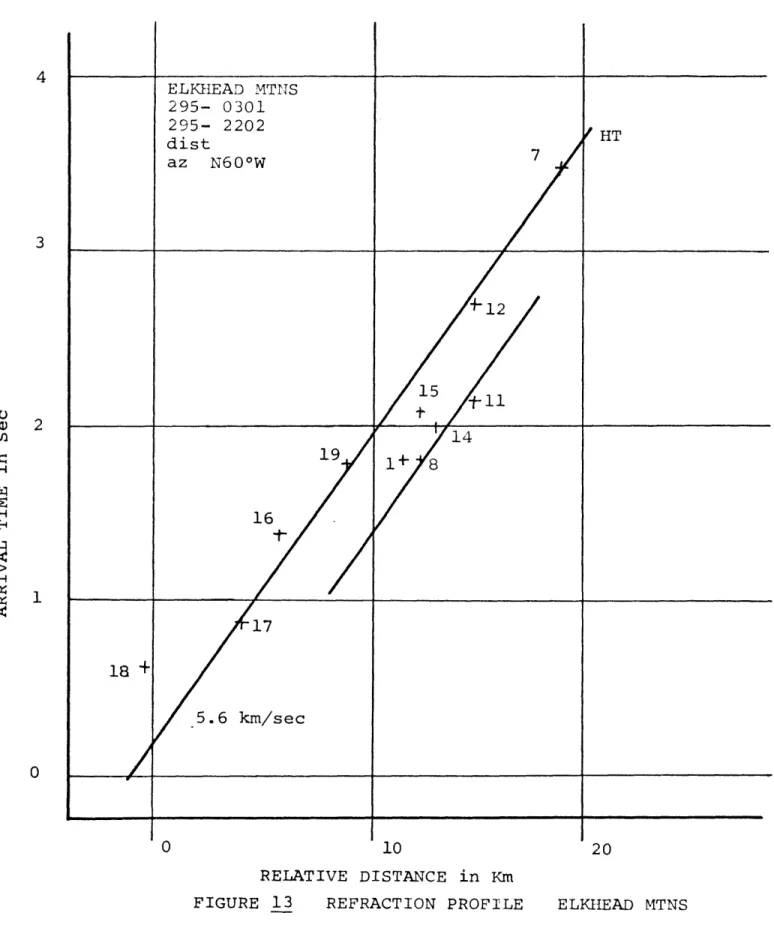
s ho w s good a g r e e m e n t w it h a p h a s e v e l o c i t y of a p p r o x i m ately 9 k m / s e c . This v e l o c i t y is s lo w e r th a n t h e e x p e c t e d v e l o c i t y of 12 k m / s e c c a l c u l a t e d from t h e normal t ra v e l time c u r v e s .N e a r - R e g i o n a l s — The ne x t p r o f i l e , figure K3, is a c o m b i n a t i o n of of two e v e n t s , both i d e n t i f i e d a s coming from th e Elkhead M o u n t a i n s . No ef fo r t, in t h i s a n a l y s i s , w a s made to d i s c r i m i n a t e t h e s o u r c e of t h e s e e v e n t s b e t w e e n p o s s i b l e n a t u r a l e v e n t s and la rg e mine s h o t s in t h e c o a l mining d i s t r i c t of n o r t h - w e s t e r n C o lo r ad o. An i n t e r p r e t a t i o n u s i n g t h e a p p a r e n t v e l o c i t y c o n s i s t e n t w it h t h e normal c r u s t a l m o d e l , (5.6 k m / s e c ) d i f f e r e n t i a t e s a n a r e a o u t l i n e d by s t a t i o n s #1, 8, 11, 14, a n d 15 w h ic h a r e f a s t w i t h r e s p e c t t o s t a t i o n s # 7 , 12, 16, 17, a n d 19. The a r r i v a l time a t s t a t i o n #18 fits n e i t h e r tr e n d a n d is l a t e by a t l e a s t 500 ms from t h e e x p e c t e d c u r v e . Although t h e s o u r c e a r e a is onl y a p p r o x i m a te ly k n o w n , t h e t r u e g e o g r a p h i c az im u t h b e t w e e n th e l o c a l a r r a y an d t h e El k he a d M o u n ta in s i s roughly N25W. The
a p p a r e n t a z i m u t h of t h e inc o m in g w a v e front d e te r m in e d from t h r e e - s t a t i o n f i t s w a s N60W.
Figure 14 s h o w s a n e a r - r e g i o n a l e v e n t from t h e w e s t - n o r t h w e s t of th e p r o s p e c t a r e a . I d e n t i f i c a t i o n of th e e p i c e n t r a l l o c a t i o n is only a p p r o x i m a te but c o r r e l a t i o n w i t h r e c o r d s a t th e GOL s t a t i o n in Bergen P ar k, C ol or ado s u g g e s t s t h a t t h e e v e n t may o r ig i n a t e from th e v i c i n i t y of Ruth M o u n t a i n . Fitting t h e a r r i v a l s to a 5 . 6 k m / s e c a p p a r e n t v e l o c i t y
A R R I V A L T I M E in S e c T - 18*4-2 31 4 ELKHEAD MTNS 295- 0301 295- 2202 dist az N60°W HT 3 15 2 14 19 1 + 16 17 18 +; 5.6 km/sec 10 20 RELATIVE DISTANCE in Km
A R R I V A L T I M E in S e c 46 45 44
12
, '
7
15 /t*
19+■
/ u
/
^
+8/
//
/
/l6
/
+ 3
/
/
'17/
REGIONAL wnw maybe RUTH MTN 297- 0100 dist 130 km a z N45 °W 18+
/
/
/
5.6*
km/sec 43 4 2 RELATIVE DISTANCE in KmT-1842 33
sho ws l a t e a r r i v a l s at s t a t i o n s #15, 18, and 19 an d e a r l y a r r i v a l s a t s t a t i o n s # 3 , an d 8. Time r e s i d u a l s a s g r e a t a s th e one at s t a t i o n #3 (almost one s ec on d) probably r e s u l t from m i s i d e n t i f i c a t i o n of th e r e fr a c t e d ar ri v a l p h a s e , p , in t h e b a c k g r o u n d n o i s e . The s c a t t e r on
y
th e plot is a r e s u l t of the u n c e r ta i n ty in l o c a t i o n . C o nt r ad ic to ry s o l u t i o n s from the t h r e e - s t a t i o n fi ts prove t h i s o u t . R e s u l t s from the th re e s t a t i o n t e c h n i q u e v a r i e d from N45W t o due nor th.
Figure s 15, an d 16, show a co m p a r i so n of the four Climax s h o t s u s in g th e s t r a i g h t - l i n e a nd r e l a t i v e d i s t a n c e s in e i t h e r p r o f i l e . Figure 15 show s a r r i v a l ti m e s p l o t t e d against, s h o t - r e c e i v e r d i s t a n c e s t a k e n normal to the a p p a r e n t az i m u t h of N25E (geog rap hic az im u t h i s due north). The e x p e c t e d p h a s e v e l o c i t y of 5 . 6 k m / s e c is c o n t r a s t e d to th e b e s t fit v e l o c i t y of 4 . 8 k m / s e c a l s o s h o w n . The four s e p a r a t e s h o t s w er e co m bi n ed by c a l c u l a t i n g t h e b e s t fit a p p a r e n t v e l o c i t y , f itt in g t h i s s l o p e to e a c h i n d i v i d u a l profile an d combi ning th e p r o fi le s by m at ch in g t h e a p p a r e n t v e l o c i t y l i n e s .
This p ro fil e r e s e m b l e s th e Elkhead M o u n ta i n s pr ofile (figure 13). An a r e a , in cl u d i n g s t a t i o n s # 6 , 7, 11, 14, a n d 15, a p p e a r s t o f i t a v e l o c i t y s i m i l a r to th e r e g i o n a l v e l o c i t y but a r r i v a l t i m e s a r e f a s t by as much a s 300 to 400 ms (with r e s p e c t to t h e ot her s t a t i o n s ) . Slow time r e s i d u a l s a t s t a t i o n s #19 a n d a f a s t r e s i d u a l at s t a t i o n #18 may be due to d i f f i c u l t i e s in i d e n t i f i c a t i o n of f i r s t a r r i v a l s an d in comb inin g s e p a r a t e s h o t s into one profile w it h o u t k n o w l e d g e of t h e t ru e origin t i m e . Figure ,16 s ho w s t h e true g e o g r a p h i c d i s t a n c e s an d th e e x p e c t e d 5 . 6 k m / s e c p h a s e v e l o c i t y . This profile s h o w s s im i l a r b e h a v i o r to the
A R R I V A L T I M E in S e c MP / C L I M A X , CO 293- 2109 294- 2100 295- 2113 295- 2252 296- 2355 dist 70 km a z N25°E 19 4 +
f
/
/ 14 4L5/
W e/
/12
/
A l l
4 / / <---- > C H A L K C R E E KA
/ + 1 7 / +1 m / 4.8 / km/sec/ T 18/
/ 4 / 5.6 km/sec 0 10 2 0 RELATIVE DISTANCE in KmA R R I V A L T I M E in S e c 13 4 CLIMAX, CO 5 shots dist 70 km az due N HT 19 + 14 3 11 12 2 1 6 1 CHALK CREEK 1 5.6 km/se 0 18 20 10 RELATIVE DISTANCE in Km
and l a t e r a l e x t e n t of t h e anorhalous zo ne is m a s k e d by the l a t e r a l r e f r a c t i o n .
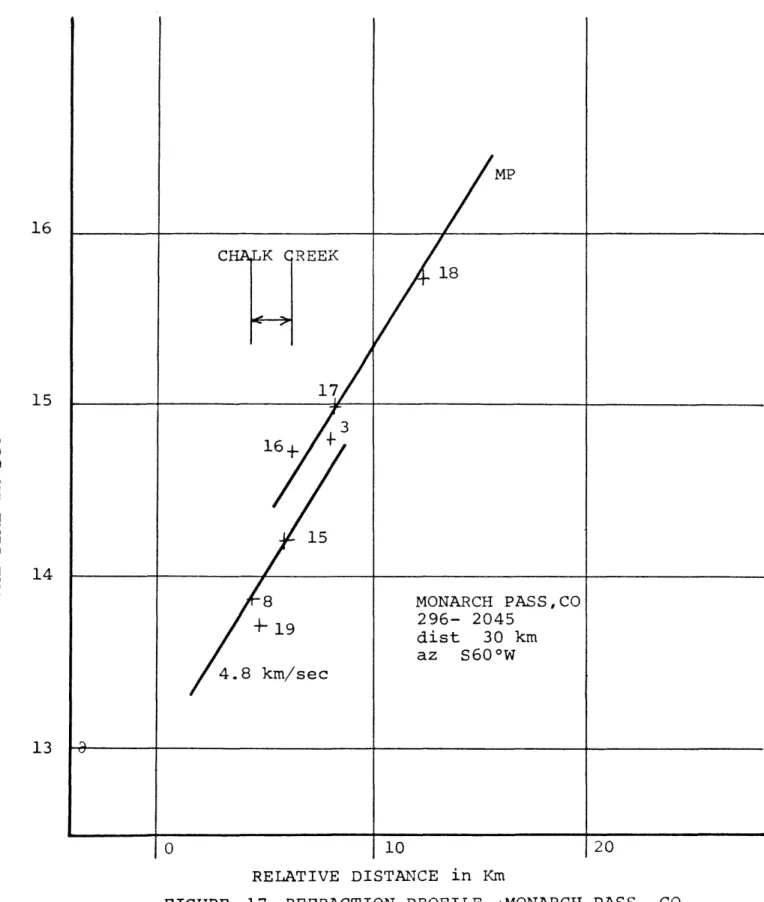
The fina l p r o f i l e , figure
17_,
s ho w s t h e Monarch P a s s e v e n t w h i c h , wi th t h e Climax e v e n t s , r e v e r s e s the r e f r a c t i o n pr ofile of the Mount Pr ince ton a r e a . U s in g t h e 4 . 8 k m / s e c a p p a r e n t v e l o c i t y d et er m in e d from t h e Climax p r o f i l e , an a r e a in cl u d in g s t a t i o n s # 8 , 15, an d 19 i s f a s t r e l a t i v e to s t a t i o n a r r i v a l s further n o r th w ar d . Fitting th e d at a po in ts to the 4 . 8 k m / s e c v e l o c i t y , bring s ou t the anomaly at Chalk Creek from a third d i r e c t i o n . W i t h o u t prior k n o w l ed g e of t h e a p p a r e n t v e l o c i t y of t h e Climax p r o f i l e , the o b s e r v a t i o n s s e e m to b e t t e r a g r e e wit h a n a p p a r e n t v e l o c i t y much s l o w e r th a n t h e v e l o c i t y s h o w n . The tru e a z i m u t h from th e c e n t e r of t h e l o c a l ar ra y t o M ona rch P a s s is S3 0W, but o n c e a g a i n t h e incom ing w a v e front s e e m s to be f o c u s e d in a more e a s t - w e s t d i r e c t i o n , a s th e a p p a r e n t a z i m u t h s o lu t i o n w a s S6 0W.Figure 18 is a plot of a m p l i t u d e v e r s u s r e l a t i v e s t a t i o n d i s t a n c e from Climax for s e i s m i c a r r i v a l s r e c o r d e d by s t a t i o n s on Line B. Only s h o t s from C li m ax , r e c o r d e d on hard rock s i t e s , w e r e u s e d . Th e se t r a c e a m p l i t u d e s w er e n o r m a li z e d to th e r e s p o n s e at s t a t i o n #18 and s c a l e d for co m p a r i s o n at o t h e r s i t e s r e l a t i v e to t h i s s t a t i o n . The l i n e th rough t h e d a t a is mean t t o d e m o n s t r a t e t h e am p l it ud e (energy) d e c a y w it h d i s t a n c e . S t a t io n s in Cottonwo od and Chalk Cr eek d i s p l a y s i g n i f i c a n t a m p l i f i c a t i o n c o m p a r e d t o t h e e x p e c t e d a t t e n u a t i o n c u r v e .
A R R I V A L T I M E in S e c T - 1 8 4 2 37 MP 16 C H A L K C R E E K 18 17 15 16 15 14 MONARCH PASS,CO 296- 2045 dist 30 km az S60°W 4.8 km/sec 13 20 10 RELATIVE DISTANCE in Km
A rough e s t i m a t e of th e dominant fre qu enc y at e a c h s t a t i o n w a s made by a simp le m e a s u r e m e n t of the per io d of th e f ir s t few c y c l e s of t h e - w a v e t r a i n . The a r e a s of r e l a t i v e a m p l i t u d e a m p l i f i c a t i o n
(shown in figure 18) a p p e a r to c o r r e l a t e wi th a r r i v a l s w i t h a pr e d o m i n a n c e of high f r e q u e n c i e s . The mo st p r on o un ce d e f f e c t , a n i n c r e a s e in th e fre qu en cy from 4hz to 8 h z , w a s o b s e r v e d a t s t a t i o n #8. The a t t e n u a t i o n and dominant f re q ue nc y a n a l y s i s w er e r e s t r i c t e d t o t h e
Climax s h o ts b e c a u s e t h e o t h e r s o u r c e s f a i l e d to prov ide t h e n e c e s s ar y r ed u n d a n c y of d at a n e e d e d in a c o m p a r a t iv e a n a l y s i s . P a s s i v e M i c r o e a r t h q u a k e Survey The p a s s i v e m i c r o e a r t h q u a k e equ ip m en t u s e d in t h i s s ur v ey a l l o w e d 2 4 - h o u r , co n t in u o u s o p e r a t i o n , s o a su rv ey to d e t e c t n a t u r a l s e i s m i c a c t i v i t y c o u ld be c o n d u c t e d a l o n g s i d e t h e a c t i v e program. During t h e s u r v e y , t h r e e e v e n t s w e r e r e c o r d e d an d i d e n t i f i e d a s l o c a l , n a t u r a l e v e n t s . Th e se t h r e e e v e n t s w e r e timed from t h e sm oked p a p e r r e c o r d s and l o c a t e d u s i n g a l e a s t - s q u a r e s - f i t l o c a t i o n program b a s e d on a c o n s t a n t v e l o c i t y , h al f s p a c e m o d e l . The t a b l e b e lo w l i s t s information a b o u t the c a l c u l a t e d origi n t i m e , l o c a t i o n an d m a g n i t u d e of t h e s e l o c a l e v e n t s .
The r e c o r d e d ar ri v a l information is not s u f f i c i e n t for r e l i a b l e de p th e s t i m a t e s , an d x and y l o c a t i o n s s h o u ld be t r e a t e d a s a p p r o x im a te (quoted l o c a t i o n s ar e w i t h i n - 2 km). For a u n iq u e s o l u t i o n in t h e l o c a t i o n pr o gram u s e d , four a r r i v a l s or t h re e a r r i v a l s a n d an origi n time a r e n e e d e d .
T R A C E A M P L I T U D E in mm N O R M A L I Z E D TO 10 mm at S T A T I O N # 1 8 T-30 C R E E C H I.LK CO1 20 13 14 19 L5 8 16 17 18 10 20 10 RELATIVE DISTANCE in Km
To l o c a t e the l o c a l e v e n t r e c o r d e d on only t h r e e s t a t i o n s (294-2051),
an s - p t i m e , re a d from th e r e c o rd at one s t a t i o n , w a s u s e d t o e s t i m a t e a n or ig in time by a s s u m i n g a P o i s s o n s Ratio of 0 . 2 5 and u s in g t h e W a d a t i Curve (plot of a r ri v a l time v e r s u s s - p time for a giv en v e l o c i t y r a t i o ) .
Table _3 Local Events
d a t e tim e UTC time l o c a l # of s ta TQ X Y Mag
294 0453 1053PM 5 12.81 +11.0 + 4 . 9 - 0 . 5 M
294 1723 1123AM 4 12.35 - 8 . 7 - 7 . 5 + 1 .2 5 M
294 2051 0251PM 3 2 4 . 0 5 +12.8 0 . 0 0 . 0 M
Loc ation c o o r d i n a t e s are in km r e f e r e n c e d t o t h e origin of the l o c a l ar ray (3 7.7 5 N an d 108.00 W ) , m a gn it u d e is q u o t e d a s body w a v e m a g n i t u d e c o r r e c t e d for d i s t a n c e and fr e q u e n c y r e s p o n s e .
The u p p e r A r ka ns as Valley an d t h e San Luis Valley a r e a r e a s of very l i t t l e h i s t o r i c s e i s m i c a c t i v i t y ( H a d s e l l , 1968). A m i c r o e a r t h q u a k e s u r v ey of t h e San Luis Valley (Keller and Ada ms , 1976) r e c o r d e d 6 l o c a l e v e n t s in a t h r e e w e e k s u r v e y , a very low l e v e l of s e i s m i c i t y c o n s i d e r ing th e s e n s i t i v i t y of t h e r e c o r d i n g e q u i p m e n t . Although t h e l e v e l r e co rd ed by t h i s s u r v e y , t h r e e e v e n t s in four d a y s , is a p p r e c i a b l y h i g h e r , the Rio Gr ande Rift Zone in Colorado s e e m s to d i s p l a y a low l e v e l of s e i s m i c i t y w i t h r e s p e c t to t h e r e c o r d e d a c t i v i t y from t h i s z o n e in c e n t r a l New M ex ic o an d to th e a b u n d a n t g e o l o g i c e v i d e n c e of r e c e n t a c t i v i t y in t h e upper A rk ans as Valley (Scott, 1970).
T - 1 8 4 2 41
INTERPRETATION
An active seismic investigation of a prospect area provides valuable information on the seismic expression of the subsurface geologic character. This information
is contained in the interpretation of travel time residuals, observation of amplitude behavior and comparison of known source-reciever geometry to the apparent azimuth of waves observed by the local array.
Mount Princeton Survey
Interpretation of these parameters from the Mount
Princeton survey suggests the following conclusions. These are discussed in detail on the following pages.
1) Interpretation of teleseisms and near-regional events in a refraction scheme aids in developing a
regional subsurface interpretation by providing travel paths from different azimuths and from different depths. A
reversed profile, including the events from southern Mexico and from Nova Zemyla, indicates that the crustal thickness increases to the north under this profile.
2) -Regional lateral refractions from the boundaries of the north-trending upper Arkansas Valley graben focus incoming seismic energy by bending the wave fronts into a
more east-west direction. These boundaries can be interpreted as the continuation of the Rio Grande Rift structure
3) The failure to record mining shots from
Questa, New Mexico and the absence of earthquake observations form the northern extension of the Rio Grande Rift at GOL, indicates high attenuation of waves through this area and the need for high-gain recording sites within the
region to more accurately determine the local seismicity. 4) A significant velocity or structural ridge exists in the subsurface of Chalk Creek, south of Mount Princeton. This east-west cross structure to the north- trending horst-graben pattern of the regional tectonic framework may be related to the Mount Princeton batholith and the other Tertiary intrusives in the southern part of the Sawatch Range.
5) Although the survey was not specifically designed to study attenuation behavior, observations of amplitude
and dominant frequency indicate anomalous behavior for stations within Chalk Creek. Amplitude amplification or, more likely a longer travel path through more competant material would be consistent with the large amplitude, high frequency and early arrival times.
Discussion of Results
•
1) Apparent velocities from the USSR teleseism were faster than predicted from a normal crustal model, which
assumes horizontal boundaries at depth. Arrivals from the southern Mexico event displayed the opposite effect. These two observations suggest crustal thickening to the north over the travel paths involved. Crustal refraction studies
T - 1 8 4 2 43
(Pakiser and Jackson, 1965), in icated a deeper crust
uderneath the southern Rocky Mountains and the Great Plains supporting this conclusion.
2) The comparison of the local apparent azimuths recorded by the array and the known source-reciever
geometry can provide valuable information concerning the horizontal velocity distribution and structural character between the array and the source. Sources from varying distances and directions can further define the subsurface picture by revealing both local detail and gross regional structure of the project area.
At this point some mention should be made of the uncertainties involved im measuring apparent azimuths.
Specifically, the question of the significance of the 3 0 degree lateral refraction quoted in this paper should be addressed with regard to the sources of error.
To evaluate this problem, careful analysis was made of two possible measures of error in the apparent azimuth determination: 1) agreement between the three-station fits over the entire array, and 2) the effect of timing errors on a single three-station fit.
After removal of solutions which varied widely from the majority of the fits (these random fits can be attributed to erroneous signal identifications or local geologic problems at specific recording locations), three-station fits agreed to within ± 5° for lateral refractions from Climax, Monarch Pass and the Elkhead Mountains.
In regard to the second problem mentioned, a sample three-station