https://doi.org/10.47260/jesge/1127 Scientific Press International Limited
Water Scarcity: Problems and Possible solutions
Nadhir Al-Ansari1, Nahla Abbas2, Jan Laue3 and Sven Knutsson4Abstract
Iraq relies in its water resources on the Rivers Tigris and Euphrates and their tributaries. It used to be considered rich in its water resources until 1970. Then, the water quantity started to decrease due to the construction of hydrological projects within the riparian countries as well as the effect of climate change. In addition, water management planning in Iraq requires number of strategies that can help to overcome the water shortage problem. In this work, the negative problems are discussed and solutions are given to solve the water shortage problem.
Keywords: Water Scarcity, Tigris, Euphrates, Climate Change, Iraq.
1 Lulea University of Technology, Sweden.
2 CQUniversity Australia.
3 Lulea University of Technology, Sweden. 4 Lulea University of Technology, Sweden.
Article Info: Received: October 27, 2020. Revised: November 1, 2020.
1. Introduction
The Euphrates River catchment area in Turkey is about 125,000 km2 (28.2%), while it is only 7,600 km2 (17.1%) in Syria and the remainder 177,000 km2 (39.9%) is in Iraq. It should be mentioned, however, that part of the catchment of the river lies in Saudi Arabia (66,000 km2), but it does not supply any water to the river except when precipitation takes place in that area which is very rare.
High discharges of the Euphrates River take place usually during March-June period where about 63% of the annual flow passes through that period. The minimum flow period is July and August. During flood time, the river carries a huge amount of sediments (Al-Ansari et.al., 1988). Elhance (1999) stated that generally the amount of sediments that is carried by the Euphrates in one day can cover an area of 600 acres with a layer 0.25 cm thick. This in fact, how the Mesopotamian plain was formed.
The Tigris River is 1,718km long and its drainage area is 235,000km2 distributed between 4 countries as follows: Turkey 17%, Syria 2%, Iran 29% and Iraq 52% (Figure 1). The river rises near lake Hazar in southeast Turkey. It runs toward the Turkish-Syrian border and forms the border between these countries for about 45km, then it enters Iraq 4 km north Fieshkhabur near Zakha city. During its course in Iraq 5 main tributaries join the main river. These are Khabur, Greater Zab, Lesser Zab, Adhaim and Diyala (Figure 1). Most of these tributaries rise from Zagros mountain range. They carry snow melt and rainfall and for this reason, depending on the phasing of these two types of flows, the flow varies greatly within the Tigris. The sediments transported by the river at Baghdad vary with the discharge from 35 to 52 million tons per year (Al-Ansari and Toma, 1986; Al-Ansari and Ali, 1986).
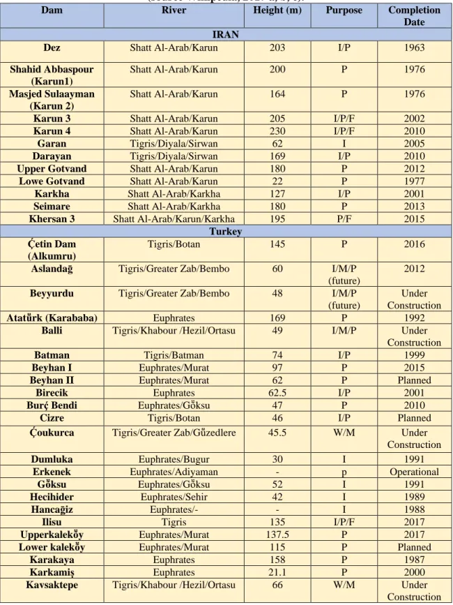
Figure 1: Tigris and Euphrates Rivers Basins (modified from ESCWA, 2013). Flow records show great variation of the flow of the Tigris and Euphrates rivers. The flow of the former can fluctuate where the high flow can be eighty times its low flow while the latter can be twenty times its low flow (Elhance, 1999). This is attributed to climate change and construction of hydrological projects. The implications of these variations led all riparian countries to build as many dams as they could to overcome these variations and to ensure availability of water (Table 1). One of such the projects, which raised tension, is the Greater Anatolia Project (GAP). This includes 22 dams and 19 hydropower stations (Ali, 2018). The other reason for building the dams is to mitigate the effect of floods (Ravindranath et al. 2016; Najibi et al. 2017).
Table 1: Constructed dams within Tigris, Euphrates Basins. (source Wikipedia, 2017 a, b, c).
Dam River Height (m) Purpose Completion
Date IRAN
Dez Shatt Al-Arab/Karun 203 I/P 1963
Shahid Abbaspour (Karun1) Shatt Al-Arab/Karun 200 P 1976 Masjed Sulaayman (Karun 2) Shatt Al-Arab/Karun 164 P 1976
Karun 3 Shatt Al-Arab/Karun 205 I/P/F 2002
Karun 4 Shatt Al-Arab/Karun 230 I/P/F 2010
Garan Tigris/Diyala/Sirwan 62 I 2005
Darayan Tigris/Diyala/Sirwan 169 I/P 2010
Upper Gotvand Shatt Al-Arab/Karun 180 P 2012
Lowe Gotvand Shatt Al-Arab/Karun 22 P 1977
Karkha Shatt Al-Arab/Karkha 127 I/P 2001
Seimare Shatt Al-Arab/Karkha 180 P 2013
Khersan 3 Shatt Al-Arab/Karun/Karkha 195 P/F 2015
Turkey Ḉetin Dam
(Alkumru)
Tigris/Botan 145 P 2016
Aslandaḡ Tigris/Greater Zab/Bembo 60 I/M/P
(future)
2012
Beyyurdu Tigris/Greater Zab/Bembo 48 I/M/P
(future)
Under Construction
Atatṻrk (Karababa) Euphrates 169 P 1992
Balli Tigris/Khabour /Hezil/Ortasu 49 I/M/P Under
Construction
Batman Tigris/Batman 74 I/P 1999
Beyhan I Euphrates/Murat 97 P 2015
Beyhan II Euphrates/Murat 62 P Planned
Birecik Euphrates 62.5 I/P 2001
Burḉ Bendi Euphrates/Gṏksu 47 P 2010
Cizre Tigris/Botan 46 I/P Planned
Ḉoukurca Tigris/Greater Zab/Gṻzedlere 45.5 W/M Under
Construction
Dumluka Euphrates/Bugur 30 I 1991
Erkenek Euphrates/Adiyaman - p Operational
Gṏksu Euphrates/Gṏksu 52 I 1991
Hecihider Euphrates/Sehir 42 I 1989
Hancaḡiz Euphrates/- - I 1988
Ilisu Tigris 135 I/P/F 2017
Upperkalekṏy Euphrates/Murat 137.5 P 2017
Lower kalekṏy Euphrates/Murat 115 P Planned
Karakaya Euphrates 158 P 1987
Karkamiṣ Euphrates 21.1 P 2000
Kavsaktepe Tigris/Khabour /Hezil/Ortasu 66 W/M Under
Kayacik Euphrates/Sajur 45 I/P 2005
Keban Euphrates 207 P 1974
Kirazlik Euphrates/Botan 60 I/P 2011
Kralkizi Tigris/Maden 113 I/P 1997
Musatatepe Tigris/Khabour /Hezil/Ortasu 34.5 W/M Under
Construction
Silope Tigris/Khabour /Hezil 79.5 W/M/P 2012
Silvan Tigris/Batman 174.5 I/P 2017
Sirrntiṣ Tigris /Birimşe 92 I 2013
Ṣirnak Tigris/Khabour /Hezil/Ortasu 56.8 W/M 2012
Uludere Tigris/Khabour /Hezil/Ortasu 55.5 W/M Under
Construction
Syria
Baath Euphrates 14 P, I, F 1988
Tabaqa Euphrates 60 P, I 1975
Tishrine Euphrates 40 P 1999
Upper Khabour Khabour I 1992
F: Flood Control I: Irrigation M: Military P: Power W: Water supply
The confluence of the Tigris and Euphrates Rivers at Qurna city forms Shat Al-Arab River. The catchment of this river shared between Iraq and Iran. The main tributary to this river is Karun, which rises in Iran. Iran tries to secure its interest in Karun and Shatt Al- Arab. Recently, Iran diverted all the waters of the tributaries, including Karun inside its borders (Abdullah, 2012).
In addition to the above, water scarcity in Iraq can be attributed to: a. International and Regional problems.
b. Internal problems.
2. International and Regional Problems.
2.1 Climate Change
Background
Iraq is one of the countries, which are highly vulnerable to climate change and to its variability (IPCC 2014). Iraq is one part of a very large zone of generally varied climatic conditions categorized by a high degree of aridity, highly variability and very low annual rainfall (Medany, 2008) and that, which can experience major environmental changes due to any climatic shift. Most of parts of Iraq are classified as having arid to semiarid climate, ranging from humid in the north to semi-arid in the south due to the typical annual precipitation being below 150 mm (Al-Ansari et al., 2017). This makes Iraq significantly vulnerable to any slight change in climate. Water scarcity has recently emerged as an issue in large parts in Iraq, particularly in the south, and could get worse due to changing climate (IPCC, 2014). Arguably, climate change is one of the greatest challenges confronting this region: it can have significantly adverse effects on water resources and hence the environment and economy, particularly in the agricultural sector. Thus, there is an imperative need for predicting the potential impacts of climate change, specifically
on the duration and magnitude of precipitation, that have ramifications for sustaining and managing water resources appropriately. It has been reported already for some regions that water scarcity has become significantly worse (Chowdhury et al., 2014; Al-Ansari et al., 2014). Unfortunately, up to-date, water issues related to climate change have not been well addressed within climate change analyses and climate policy construction (IPCC, 2014) and, particularly, in Iraq, where very little attention has been paid to climate change-related water resources issues (Issa et al., 2014). Given this perspective, the main objective of this section is to highlight the observed changes in climate trend and streamflow as well as the adverse impacts of these changes that have already impinged on the water sector and keeps to do so and hence hitting the agriculture sector in Iraq.
Observed climate and trends in Iraq
The primary controlling factors of a climatic regime are atmospheric temperature and precipitation. If these two factors change, other factors such as humidity will be affected. It is therefore imperative to study thoroughly changes in atmospheric temperature and precipitation to investigate possible climate change. This section describes the observed and projected changes in climate as they relate to water in this region.
2.2 Air temperature
Climate shift in all regions of the world has been significant since the last century, mainly through observed increases in surface air temperature (IPCC, 2014). Since the 1950s the average temperature has increased by 0.2°C to 0.3°C per decade (Zakaria et al., 2013). Recent studies have shown that the air temperatures in the last three decades (1980-2017) in Iraq has risen by 0.7°C per decade (Abbas et al., 2017). The IPCC (2014) points out that Iraqi surface air temperature had increased unevenly from 1970 to 2003, ranging from 0.2°C to 2°C, and it is expected to increase by about 5°C by the end of the 21st century (Abbas et al., 2019). These changes will give rise to a higher level of climate variability; potentially resulting in a higher frequency of extreme weather events.
2.3 Rainfall
Zakaria et al. (2013) show that an increase and decrease of average annual rainfall occurred over the historical periods 1900-1930, 1930-1960, 1960-1990 and 1990-2009. The average annual rainfall for the four historical sub-periods was182.5, 194.7, 168.9 and 162.6mm, respectively. Comparing the first and the second sub-periods, the total rainfall value showed a percentage increase of 6.68%. However, from the second to the third sub-periods the total rainfall showed a percentage decrease of 13.25%. From the third to the fourth sub-periods the total rainfall decreased again by 6.3 mm with 3.73% reduction. The average annual rainfall was decreasing from 194.7 mm during the period of 1930 -1960 to reach its lowest value of 162.6 mm during 1990-2009 (Figure 2). These results are in line with the findings
of Abbas et al. (2017) who state that rainfall has declined from about 177mm in 1980 to 156 in 2017. Abbas et al. (2017) also point out that the decline trend is expected to continue over the next decades.
Figure 2: Average annual rainfall (mm) over the historical and future periods (Zakaria et al., 2013).
2.4 Weather pattern changes
Several profound issues that can be attributed to climate change have been apparent in the Iraqi climate. The desertification processes, frequent and intense dust storms, rising air temperatures above 50°C, prolonged drought conditions and sudden, heavy rainfall and storms have become increasingly frequent in the Iraqi climate (Janabi, 2013). For example, the extreme drought that occurred between 2005 and 2007 was followed by several months of sudden heavy rainfall and storms during which vast parts of central and southern Iraq received 200% of normal rainfall (UN, 2013). The effects of significant changes in weather patterns are exacerbated by inability to store water during rainfall events, abandonment of agricultural land during drought, reduction in flow rates in the Tigris and Euphrates Rivers, shrinking of the marshlands, soil erosion and an increased salinity in the Shatt al-Arab estuary as well as in groundwater in the south.
Climate change and its impacts on water resources
Besides the challenges mentioned above that are facing Iraqi’s rivers waterflow, climate change and significant increases in population growth are exacerbating water scarcity. Climate change warns to decrease water availability and deteriorate water quality (Al-Ansari et al., 2014; Abbas et al., 2020). Iraq is one of the region’s countries that is considered most vulnerable to climate change (IPCC, 2014). The impacts of climate change have been obvious, as air temperatures increase is
resulting in increasing evaporation, declining precipitation, and changing weather patterns that are contributing to water scarcity. According to observed studies, scarcity of fresh water and the rise in sea level in Iraq has been felt and noticed in last few decades. Iraq’s rivers discharges have decreased to less than a third of their normal flow and are expected to decrease further by an alarming 50% by 2030, compared to 1980s due to water-related activities of upper riparian countries and climate change (Al-Ansari et al., 2014; Chenoweth et al., 2011). Abbas et al. (2020) evaluated water resources per capita per year during the period of 1980-2014 in the northeast Iraq. They found that the water use per capita has decreased in the southern part and has experienced less than 500 m3 per capita per year (Figure 3) with high spatial distribution due to the geographic factor, water availability decreases from upstream mountainous areas to downstream flat areas since annual precipitation decreases from north to south. The social factor is that northern areas are sparsely populated, whereas southern areas are densely populated with some large metropolitan areas, resulting in decreased water quality. In general, a major part of the region is experiencing severe water scarcity which corresponds to areas with high population density adding more complexity to the problem.
Figure 3: Water availability in northeast Iraq in 2005; average annual blue water flow availability per capita per year using population of 2005
(According to Abbas et al., 2020).
Abbas et al. (2020), investigated further soil water content in northeast Iraq, which although is often ignored in water resources management, it plays a fundamental role in rain-fed crop production and for other environmental purposes (Zang et al., 2012). Abbas et al. (2020) assessed the soil water availability by the average number
of months per year for the period 1980-2014 when soil water content is available (defined as >1 mm.m-1) as shown in Figure 4. Soil water content availability analysis showed that, apart from the Khbour Basin, which has experienced nine to ten months when soil water content was accessible, the four tributaries catchments have experienced five to six months per year of groundwater availability. Therefore, large areas of the region can often experience reduced crop yield due to lack of soil water availability, particularly downstream catchments such as the Al-Adhiam Basin. These areas require irrigation systems, which can adjust to high demands or adoption of alternative cropping practices that require less water.
To gain an appreciation of what is going on at local levels, where transportation of water mostly seems infeasible due to lack of infrastructure, Abbas et al. (2020) looked at four townships: Duhok, Al-Sulaymaniyah, Erbil and Al-Ta’mim (Kirkuk governorate). These range from high- to low-precipitation townships. The results of the analysis are presented in Figure 5. The locations of the townships are shown in Figure 6. The soil water content at Al-Ta’mim is not as poor as it may appear from the precipitation values only.
Figure 4: The 1980–2010 average soil water content (Ground Soil Water, GWS).
Figure 5: Simulated average (1980–2010) annual city precipitation (PCP), surface water flow (BWF), ground water flow (GWF) and soil water content
(GWS) for four major cities in northeast Iraq.
Figure 6: The map showing the location of townships where water resources
availability was looked at township level (Iraqi Ministry of Water Resources, 2015).
Abbas et al, (2020) modelled the impacts of climate change on northeast Iraq for distant future (2080-2100). They found that the basin will experience increasing temperatures and decreasing annual precipitation that will have far-reaching consequences, with the highest impact in the southern part and likelihood of rising temperatures up to 50C. The results from the hydrological modelling for annual stream flow show that in five tributaries streamflow will significantly decrease for all scenarios. These findings may have significant effects, because a large area already suffers from per capita water scarcity.
Besides the negative climate change impacts, water resources have been pressured by continued contamination, salinization of the two rivers , due to the excessive use of fertilizers, and discharge of industry effluence and domestic waste and sewerage without sufficient treatment (Al-Ansari et al., 2014).
Impacts of climate change on Sea Level Rise (SLR)
Globally, mean sea level has increased by 200 mm since the late 19th century at a rate of 2.8 mm/year (Figure 7). Rising sea levels have accelerated to 3.2 mm/year over the last three decades (Lough and Hobday, 2011) at a rate near to the upper end of the Intergovernmental Panel on Climate Change projections (Keenan and Cleugh, 2011). This is mostly due to thermal expansion of the oceans, with a small contribution from the loss of mass from land ice (Church et al., 2006; Gregory and Huybrechts, 2006).
Al-Ansari (2016) reported that the Arabian Gulf is projected to be highly vulnerable at its northern part, north of Kuwait and south of Iraq (Shat Al-Arab), to SLR. Despite the limited shoreline of Iraq on the Arabian Gulf, SLR would impact the major cities in Iraq such as Basra and Baghdad due to low elevation of the lands (Al-Ansari, 2016; Figure 8). SLR would potentially have impacts on increasing soil salinity due to saltwater intrusion and may cause serious inundation of many parts of the region. The other possible impact is land inundation, due to the very low elevation of the land, make it highly susceptible to any amount of sea level rise (El Raey, 2011).
Figure 7: Global Mean Sea Level (GMSL), 1880-2020 (Church and White, 2006).
Figure 8: Effect of sea level rise in Iraq and Kuwait (Al-Ansari, 2016). Impacts of climate change on Agriculture
Agriculture is the second largest contributor to the country’s gross domestic product, and it is the main source of livelihood for 25% of the population (USAID, 2017). Agriculture is mainly categorized by small-scale farms that are almost rain-fed in the north and irrigated in other regions. Climate change impacts on agriculture have been evidenced in recent decades (Al-Ansari, 2013). The ongoing decline of the agricultural sector, driven partially by climate change, has been increasingly noted in the sustained loss of arable land, productivity losses, and decline in agriculture’s overall contribution to GDP (Ministry of Foreign Affairs, 2017). USAID (2017) has identified three stressors related to climate change which are: increased
temperatures, Greater Frequency and Intensity of Drought and Increased Intensity of rainfall events.
Increased temperatures stress
Increased temperatures have led to reductions in the agricultural productivity in the large part of Iraq (USIAD, 2017). Temperature is a key factor contributing to the rate of plant development. Warmer temperatures associated with climate change have declined plant productivity worldwide (Al-Ansari, 2013). Plants exposure to temperature extremes at the commencement of the reproductive stage have a major impact on fruit or grain production across all species (Hatfield and Prueger, 2015). Greater Frequency and Intensity of drought
Climate change has impacted a large agricultural part in Iraq by increasing desertification, deteriorating agricultural development, and diminishing livestock, which resulted from degradation and lack of natural vegetation. This in turn has negatively affected the human and food security of the country. Continued decreased rainfall and runoff have been a significant contributor to widespread desertification and sand and dust storms resulting in arable land loss (USAID, 2017). It is estimated that desertification threatens 92 % of the country. During the drought between 2007-2009, mostly 40% of cropland throughout Iraq experienced reduced crop coverage and livestock were perished. The situation caused 20,000 rural inhabitants to move in search of more sustainable access to drinking water and livelihoods (USAID, 2017). The events of dust storms (sandstorms) have enormously increased, as compared with those occurring during the last century due to climate change (Sissakian et al., 2013). Dust storms have undermined Iraq’s agricultural sector. Sand and dust storms endanger cropland and productivity due to soil loss, reducing soil fertility, and removing organic matter (Al-Ansari, 2013). Currently, dust storms sometimes occur at a rate of over 100 times/year but could occur up to 300 times annually in ten years. Further reductions in arable land and productivity could also result in loss of livelihoods and increased food insecurity (Janabi, 2013). Figure 9 shows the widespread of sand and dust storm in Iraq. Increased intensity of rainfall events
In Iraq, climate change has been responsible for unpredictable precipitation, higher than average and increased disaster risk intensity. In 2013 (USAID, 2017; Janabi, 2013) severe flooding damaged approximately 75,000 acres of cropland in south-eastern and south-eastern Iraq. In 2019, Iraq experienced an oddly wet winter leading to restoring freshwater marshes of southern Iraq, however caused widespread flooding on the Tigris and Euphrates rivers.
Without immediate adaptation measures taken, the agricultural production will suffer more significantly. Rain-fed agricultural lands and production will likely decrease significantly because of shorter growing seasons and less precipitation (Al-Ansari et al., 2014).
To avoid future generations having to pay a premium price to deal with the adverse effects of climate change, it is imperative that these aspects are taken into consideration in formulating climate change policies for the region. Relevant policies to deal with climate change in the field of water resources may include, for instance, recycling of waste water, steps and measures to mitigate and adapt to these impacts through (for example) water-reuse measures, water-sensitive urban infrastructure design such as rainwater tanks, rain gardens and constructed wetland, and growing plants tolerant to drought.
Figure 9: Spatially distribution of dust and sandstorm event throughout Iraq (Al-Ansari, 2013).
3. Conclusion
Although it is not easy to draw concrete conclusions on climate change impacts on water resources in Iraq, due to extreme shortage of modelled studies in this area, it can be seen clearly from few observed and modelled studies that the region is subjected to extreme negative climate change impacts on water and land resources. These will inevitably have absolute severe circumstances for Iraqi community such as poverty, unemployment, lack of agricultural products. Enormous volume of studies and research should be done for the whole region to fill the gap of lack of knowledge of climate change impacts- related water issues. This would support decision makers in planning relevant adaptation and mitigation policies, and thus decreasing the expected adverse impacts on water resources in the basin.
3.1 Hydrological Projects within Riparian Countries
All landowners whose property adjoins a body of water or river have the right to make reasonable use of it and the right to access for swimming, boating and fishing as it flows through or over their property. If water is lacking to satisfy all landowners, rations are generally fixed in proportion to frontage on the water source (Guerin, 2003).
Many studies tried to draw figures for the water requirement for Turkey, Syria and Iraq (the riparian countries) from Euphrates and Tigris Rivers. Estimates for required water from Euphrates River to irrigate all the cultivated lands along it are 15.7, 11 and 13 km3 for Turkey, Syria and Iraq, respectively. It should be mentioned however that, other authors had cited different figures for the water requirement for Turkey, Syria (7.95 km3 ) and Iraq (19 km3 ) (Kamona, 2003).
During the 1970s Syria and Turkey started to construct dams on the Euphrates and Tigris Rivers which caused a major decrease in the flow of the rivers (Al-Ansari, 1998; Al-Ansari and Knutsson, 2011) as well as deterioration of the quality of their water (Kamel et.al., 2013).
In 1977, the Turkish government set a huge project referred to as Southeastern Anatolia Project (GAP, 2006). The component of the project includes 22 dams and 19 hydraulic power plants which are supposed to irrigate 17,000 km2 of land (Unver, 1997). The project is supposed to develop the southeastern provinces which cover 9.7% of the total area of Turkey which forms 20% of the agricultural land of the country. The overall volume of water to be captured is about l00 km3 (while the required water to irrigate the supposed area is about 29 km3) which is three times more than the overall capacity of Iraq and Syrian reservoirs. Despite the continuous claims of the Turkish Government that GAP is purely development project, it seems that there are number of internal and external goals involved (Shams, 2006; Alnajaf News Net, 2009; Waterbury, 1993; Alsowdani, 2005; National Defense Magazine, 2009). When GAP project is completed, then 80% of the Euphrates water will be controlled by Turkey (Beaumont, 1995; Alyaseri, 2009; Robertson, 2009).
When Ilisu dam on Tigris River is operating then, Iraq will receive only 9.7 km3 (Ritzema and Braun, 1994). This implies that 47% of the river flow will be depleted. This in turn means that 696,000 ha of agricultural land will be abandoned due to water scarcity (Al-Ansari and Knutsson, 2011). Recent reports state that Tigris and Euphrates rivers will be completely dry by 2040 (UN, 2010).
Syria built three main dams along Euphrates River with a total storage capacity of 16.1 km3 for irrigation and electricity generation.
Syria used to receive 21 km3/year of the Euphrates water prior 1990 which dropped to 12 km3 in 2000 onward (40% reduction). As far as Iraq is concerned, the volume of water received dropped from 29 km3 before 1990 (Majeed, 1993) to 4.4 km3 (85% reduction) now. Due to this reduction in water shares, the agricultural used land in both countries had been reduced from 650,000 ha to 240,000 ha. In addition, the quality of water deteriorated due to back water irrigation directed toward the main channel in its upstream reaches (Al-Ansari and Knutsson, 2011).
Syria is planning to double its irrigated area (740,000 ha). This will increase its water withdrawal from 5 km3 to 9 km3 (World Bank, 2006).
In addition to the above, Iran had recently diverted all perennial valleys running toward Iraq inside Iran. Furthermore, water of Karkha and Karun Rivers had been almost completely diverted inside the Iranian borders and no water is contributing to Shatt Al-Arab River from these tributaries (Figure 10).
Shatt Al-Arab River is formed after the confluence of Tigris and Euphrates Rivers at Qumah in Iraq. Karun and Karkha Rivers usually contributes 24.5 and 5.8 billion cubic meters (BCM) annually respectively. This forms about 41 % of the water of Shatt Al-Arab. The decrease of the water discharge of the Tigris and Euphrates Rivers and the diversion of the water of Karun and Karkha tributaries caused the salinity to increase to 2408 mg/I in 2011 (UN-ESCWA and BGR, 2013).
Figure 10: Schematic diagram of Tigris, Euphrates and Shatt Al-Arab Rivers system (UN-ESCWA and BGR, 2013).
Causes of the Friction, Tension and Conflict a. Water Availability
Different figures are published for the water allocation per capita per year (Tables 2 and 3). The figures given do not include restoring of the marshes in Iraq, and it ignore the situation when GAP project is fully operating. Irrespective of the numbers given, Turkey claims that the allocations of water per capita in Iraq and Syria are sufficient to fulfill the requested quantities that achieve the people needs in these countries (Altinbilek, 2004).
Table 2: Water allocation per capita per year in Turkey, Syria and Iraq (source of data a- Bilen, 2000; b- Turkish Ministry of Foreign Affairs, 2012).
Country Water Allocation (m3/Capita/year)
1990 2000 2010 2020
Turkey 3223 2703 2326 2002a, 980b
Syria 1636 117 880 760a,780b
Iraq 2352 1848 1435 1062a,950b
The flow of the two main rivers is decreasing with time (Figures 2, 3 and 4). This is mainly due to the Turkish policy of build the dams in the upper parts for the catchment areas of the Tigris and Euphrates and climate change (Al-Ansari et.al., 2014a, b; Osman et.al., 2017a, b, c; Al-Ansari, 2013, 2016; IPCC, 2007). Surface and groundwater resources will be decreased with time (Voss et.al, 2013; Chenoweth et.al, 2011; Bazzaz, 1993). Future predictions suggest lower precipitation accompanied with higher temperatures (Al-Ansari et.al., 2014d). Serious consequences are expected where (as an example, 71% of the Euphrates River is come from precipitation in Turkey), (UNDP, 2011). This condition will lead to more evaporation and drought periods (UNEP, 2011; Hameed et al., 2018). UN (2010) report indicated that these conditions will eventually lead to the dryness of the Tigris and Euphrates Rivers by 2040. In addition, all riparian countries within the catchments of the two rivers will be most water stressed by 2040 (Maddocks et al., 2015).
b. Population growth rate and food security
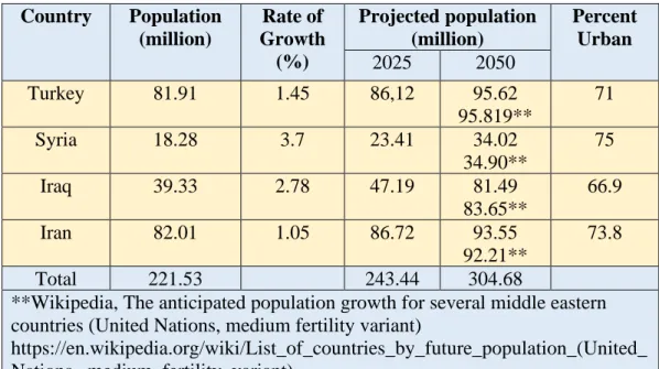
Population growth rates are relatively high in the ME particularly Syria and Iraq (Drake, 2007). Historically, the area (Arab countries only) was populated with about 20 million inhabitants in 1750, and the number in 1996 is 286 million (Drake, 2007). As far as the four main countries that lie within the Tigris and Euphrates basins (Turkey, Iran, Syria and Iraq) their total population is 221.53 million inhabitants (Worldmeter, 2018a, b, c, d). This number will increase by about 10% in 2025 and about 37% in 2050 (Table 2). Accordingly, the allocation of water per capita will decrease too (Abumoghli, 2015). The allocation within the Tigris and Euphrates basins is about 975.3 m3/yr/capita now (Table 3) and this will drop to 887.6 and 709.2 m3/yr/capita in 2025 and 2050 respectively. It is noteworthy to mention that there are other references that give different figures, but the outcome is the same
where there will be decrease in water allocations with time.
Table 3: Population Characteristics within Tigris-Euphrates Basins (modified from Worldmeter, 2018a, b, c, d and Drake, 2007).
Country Population (million) Rate of Growth (%) Projected population (million) Percent Urban 2025 2050 Turkey 81.91 1.45 86,12 95.62 95.819** 71 Syria 18.28 3.7 23.41 34.02 34.90** 75 Iraq 39.33 2.78 47.19 81.49 83.65** 66.9 Iran 82.01 1.05 86.72 93.55 92.21** 73.8 Total 221.53 243.44 304.68
**Wikipedia, The anticipated population growth for several middle eastern countries (United Nations, medium fertility variant)
https://en.wikipedia.org/wiki/List_of_countries_by_future_population_(United_ Nations,_medium_fertility_variant)
Governments in the ME try to attain food self-sufficiency and for this reason, the agriculture is considered as the largest consumer for water, it is consume 66% of the total demand (Hiniker, 1999; Allan, 2001). Countries within the Tigris and Euphrates basin allocate as an average 84.3% of the water consumption for agricultural purposes (Table 4). Iran has the maximum water allocation (92%) While Turkey (73%) has relatively the minimum water allocation for agriculture (FAO, 2008a, b, c, d). Thorough consideration of agriculture is required to objectively analyze and adequately address the water shortage problem (Sadik and Barghouti,1995). However, this is not the case where countries have extremely ambitious goals to secure the self-sufficiency of food, and they require a core changes in water management policies and widens their national outlook (Charrier and Curtin, 2007). Recently, achieving the increasing demands for water represent a severe challenge because it is over the abilities of each individual country (Sadik and Barghouti, 1995). Turkey is trying to convert the area of the GAP into a breadbasket, and this threatens the irrigation based agricultural potential of the lower riparian Syria and Iraq (Hillel, 1994). Iraq and Syria were exporting the grains for different countries, but now they are importing their needs for grains, and their agricultural production decreased to become less than Turkey (Hillel, 1994). Syria tried long time ago to achieve food self-sufficiency and to increase its irrigational areas; drip irrigation was used. As a result, severe reduction in wheat yield has been occurred; it was a decrease up to 50%. In addition, huge portion of livestock died due to water scarcity. Consequently, many individuals joined to the insurgents to
save themselves and their families (New York Times, 2013). Iraq tried to increase its agricultural lands and become a grain exporter again by 2017 (United Nations and World Bank, 2003; Al Ansary, 2015). Numerous projects were executed but salinity and water logging created serious problems for agricultural activities. After the second Gulf war, Iraq is importing its food reflecting disastrous agricultural conditions (Robertson, 2009; Cockburn, 2009). Recently, food security and self-sufficiency are not a major concern in both Iraq and Syria where national security problems, especially the threat of ISIS is the priority now.
Table 4: Water use in countries within Tigris and Euphrates basins (according FAO 2008a, b, c, d and 2009 a, b, c).
Country Water Allocation Per inhabitant (m3/y) Cultivated area (ha) Water withdrawal (106 m3/y) Total Irrigation +livestock Municipalities Industry Turkey 563 26,606,000 40,100 29,600 73% 6,200 4,300 Syria 921 5,742,000 16,690 14,669 87% 1,426 595 Iran 1356 18,107,000 93,300 86,000 92% 6,200 1,100 Iraq 2632 6,010,000 66,000 52,000 79% 4,300 9,700 Total 216,090 182,269 84.3% 18,126 8.4% 15,695 7.3% c. Energy Requirements
Iraq is an oil exporting country since the beginning of the twentieth century, while Syria started to export oil in 2001 and, Turkey has no oil reserves (Akanda et.al., 2007). For this reason, Turkey is trying to reduce its dependence on oil imports as an energy source. To achieve this goal, Turkey is trying to use hydroelectric power to cover as much as 40% of the required energy (Turan, 2004). The GAP project is one of the strategies used so that Turkey can reduce 28 million tons of its oil imports when this project is fully operational (Bagis, 1989).
Syria and partially Iraq relies on hydropower to generate electricity. Despite the fact that Syria is oil producer, but it relies on hydropower to generate electricity. This fact gives the opportunity for Turkey to decrease the water quantities which release from the Euphrates through the GAP project and put Syria under threat. Although, the Turkish Government declared several times that the GAP is purely a development project. Some people believe there are several external and internal strategies involved within the implementation of the GAP project (Waterbury, 1993; Alsowdani, 2005; Shams, 2006; Alnajaf News Net, 2009; National Defense Magazine, 2009).
d. Water Management
Poor water management strategies have exacerbated the water scarcity problems within riparian countries (Abumoghli, 2015). Water is wasted through old irrigation techniques where flood irrigation is still the dominant method used. In addition, the irrigation canals are unlined and/or uncovered, which enhance water losses. Water qualities of the rivers are deteriorating due to the extensive use of chemical fertilizers and pesticide. Back flow from irrigated areas and dispose of the industrial and municipal wastes into the rivers is accelerating the contamination of these rivers. Recent data for the period 2000 to 2010 collected by the Consulting Engineering Bureau at Baghdad University (CEB, 2011a) show the steady increase of the salinity in both rivers (Figure 11). Similar trend was noticed by ESCWA (2013) for long term salinity trend in both rivers. TDS is about 300 ppm at Ataturk Dam on the Euphrates, and it increases to 600 ppm at the Syrian-Iraqi borders which are much more than the recommended TSD concentration for irrigation, and it is continued to increase for more than 1200 ppm (minimum) downstream in the Iraqi southern. Specifically, at Samawah (World Bank, 2006; Iraqi Ministry of Municipalities and Public Work-IMMPW, 2011). As far as the salinity within the Tigris River, it increases dramatically downstream Baghdad due to intensive irrigation. To overcome the salinity problem in Iraq, a main outfall drain (MOD) was constructed south of Baghdad to the Gulf for a distance of 565 km to carry drainage water from irrigation projects from 150,000 km2 with a discharge capacity of 210 m3/s (UNEP, 2003; Shahin, 2007). To overcome salinization and water logging, huge networks and sub-surface tile drains, and surface drainage canals were constructed to collect drainage water from agricultural fields to be dumped in MOD (FAO, 2003; Taylor and Francis Group, 2003). Taking all these measures, recent estimates indicate that 4% of irrigated areas are severely saline, 50% are of medium salinity, and 20% are slightly saline (CEB, 2011b). Salinity increase in conjunction with decrease of flow downstream along the two rivers stream has been adverse effects on the agricultural areas which they located in the south of Iraq. This situation generates a resentment and frustration and lead to raise the irritation that might cause a conflict.
e. Economic Development
The ME is going through a development stage which caused the movement of about 50% of the population from rural to urban areas. Such movement aggravates the issue of water shortage where water consumption increased about 10 to 12 times its normal per capita as village dwellers (Drake, 2007).
Figure 11: Salinity variation along the Tigris and Euphrates Rivers for the period 2000-2010 (sources of data CEB, 2011a).
Furthermore, the relative fast increase in oil prices caused rapid economic developments and raised the standard of living in Iraq and Syria (Abumoghli, 2015), although the economies of both countries are hardly affected by corruption and the struggle with ISIS in the past few years. The two countries raised their need for water in view of these developments. When the claimed needs for Turkey, Syria and Iraq are added it sum up to 149% of the total water available (Akanda et.al., 2007). Since Turkey is not considered as one of the countries that produce oil, it is trying to use its water as a commodity for bargaining where in 1992 the Turkish president was announced the ceremony of opening the Ataturk dam that “Neither Syria nor Iraq can lay claim to Turkey's rivers any more than Ankara could claim their oil… The water resources are Turkey’s; the oil resources are theirs. We don't say we share their oil resources, and they can't say they share our water resources” (Reed, 2005). Furthermore, Turkey proposed Peace Pipeline and Manavgat River project focus to trade water with Mediterranean and ME neighbors (Kolars, 1994; Martin and Kerids, 2003).
f. Technological Development
The riparian countries built several dams on the Tigris and Euphrates Rivers and are planning to build more dams. The ME well known with its high temperatures and the construction of these dams have increased the quantity of evaporation from the surface water of the reservoirs. Furthermore, agricultural practices still not modernized where old irrigation methods are still used. Such practices are also leading to high quantities of water losses. Syria exerted efforts to use modern techniques in irrigation systems and it faced plenty of problems (Varela-Ortega and
Sagardoy, 2003; Friedman, 2013). One of the main problems that farmers were not educated and could not understand and apply the new technologies.
g. Political Fragmentation
ME was dominated by the rule of Ottoman Empire since the thirteenth century till its defeat and dissolution during World War I. Then the area was divided into different countries, but Britain and France ruled them. During these periods, less conflict took place among the people of this area. Afterwards, the ethnic tendency for the region increased, which contributed to raising the disparities between these country`s people. Consequently, the political and economic competition became more sever and the people more nationalistic. The tension and friction between the United States of America and the Soviet Union and their allies during what is known as the “Cold War” had a restraining impact on the chance of major conflicts, and this does not exist now.
Excessive use of water resources and water pollution became main factors for tension and clash. The 1967 war between Arab states and Israel is an example that reflects this fact where water was one of the hidden reasons. As well as the Israeli occupation of Lebanon in 1982 where they controlled Litany River and diverted its stream. To meet the high-water demand, Israel is extracting 40% of its water from aquifers beneath the West Bank and Gaza (Drake, 2007). Plenty of dams were built on the Tigris and Euphrates Rivers and their tributaries (Table 1). Unilateral decisions without any consultation with riparian countries also raised friction (Abdullah, 2012). As an example, the tension between Syria and Iraq in 1974 over the Euphrates water sharing. Future prediction models for surface water and groundwater resources show their depleting in the ME (Bazzaz, 1995; Al-Ansari et.al., 1999, 2011, 2012; Chenoweth et.al., 2011; Voss et.al. 2013; ESCWA, 2013; Hamdy, 2013). For these reasons, UN Secretary General Boutros Boutros-Ghali said in 1985 that the next war in the Near East would not be about politics, but over water (Venter, 2008).
h. International Water Laws
The International Law Commission of the UN worked on the Convention on the Law of the Non-Navigational Uses of International Watercourses for three decades, and it was approved by the United Nations General Assembly on the 8th July, 1997. Three countries voted against this law. These countries were: Turkey, China and Burundi (Elhance, 1999). This convention needs however to be ratified by thirty-five countries in order to enter into force, which it had not attain hitherto. In this law, the UN stated rights and obligations that states could follow. It also gave the principals and mechanisms that states should follow to avoid dispute escalating to the level of acute conflicts. This law could be adequate for non-arid zones and not for an arid region such as ME (Al-Ansari, 2016). In addition, despite the principals stated, there are no international legal commitments to force the countries to share their water (Morris, 1992). Having this situation, then agreements will depend upon several factors like: the goodwill of the countries which they shared the drainage
basin, the available internal and external power and the national benefits for the country to keep going to its politics (Jones, 1995).
i. Public Awareness:
Despite the fact that Syria and Iraq are facing water shortage problems now, it is expected that all countries within Tigris and Euphrates basin will experience the same situation in the future. This is due to increase of population and development in these countries. This implies required improving the present water supply efficiency and demands to fulfill the sustainability through secure the required water for future generations. To achieve such goal, all parties concerned are to be involved (Schaap and Steenbergen, 2002).
A strategy to be adopted to construct a comprehensive public awareness program about water, which comprises promotional and practical activities, and observing and assessing their effectiveness. Al-Ansari (2016) suggested educating the decision makers in the water sector such as water planners, managers and marketers; and the politicians who involve in set the external and internal water policies; and the educators about the significance of water conservation in the sector of potable water supply and how it may be approached. Subsequently, they will be contributed to transfer the benefits of the awareness program into society individuals as a whole. Special syllabus in schools is to be designed to increase awareness for water significance by developing and finding methods to present this subject, and the media should have a vital role in identifying the importance of water issues. Farmers are to be trained on utilize of modern irrigation systems which they are convenient for arid regions since the agricultural sector is the highest consumer of water resources. Using non-conventional water resources should be taken seriously. The public should understand the importance of proper water management. The ignorance of the impact of political and economic decisions of the long-term guarantee of water resources is one of the biggest problems in the ME (Al-Ansari, 2016).
Texas Water Development Board (2010) set a program for water conservation and use that can be adopted by the countries concerned. The main points in this program can be summarized as follows:
• What is the legislation that applied in granting the permits for water and wastewater?
• How is the water produced and distributed?
• What are the methods of collecting and treating the wastewater?
• What are the services, quality and methods of maintenance, which are provided by your utility?
• What kind of customer service does your utility provide? • What conservation measures are in place?
As an example, it is noteworthy to mention that Iraq is expected to have -20.6 billion cubic meters in 2040 (Figure 12, MacQuarrie, 2004). Such a figure raises the alarm, and action should be taken starting now.
Figure 12: Iraqi Water Balance 1990-2040 (bcm) (MacQuarrie, 2004). International Agreements
a. Historical Background
Turkey, Iran, Syria and Iraq are the main riparian countries within the Tigris and Euphrates basins. Since Syria and Iraq are the downstream countries within the basin, so they are always trying to ensure the required amount of water that can meet their domestic, agricultural and industrial demands. In addition, they consider that these basins as international “watercourses” which should be treated as an integrated entity by all the riparian users. On the other hand, Turkey considers the Euphrates and Tigris Rivers as “trans-boundary Rivers” where both are under Turkish authority until they across the border, and when they united together to form Shatt Al-Arab River then it becomes an international river. In addition, in 1997, three countries voted against the International Law Commission of the United Nation on the law of Non-Navigational Uses of International Watercourses one of them is Turkey. Turkey also considers this is not legally binding because the convention does not apply to them (Gruen, 2000). Furthermore, Tigris and Euphrates Rivers basins are considered as one basin by Turkey according to the fact of formation Shatt Al-Arab River from their gathering, in addition to mass water transfer between the Tigris and Euphrates Rivers via the Tharthar system, while Syria and Iraq suppose that each river had independent basins.
Historically, the Tigris and Euphrates basins were under unitary authority of different empires and colonies (Elhance, 1999). Water issues disputes that took nationalistic character started after the British and French mandates were dissolved. Before World War II, the first signed treaty was in 1913 between Britain, Russia, Iran and Turkey for the regulation of Shat Al-Arab River. France and Great Britain
as a representιng power for both of Syria and Iraq, respectively, they signed an agreement in 1920 to establish a committee that coordinates the efforts toward the utilizations of the Euphrates and Tigris Rivers (Berardinucci, 2010; ESCWA, 2013). This was followed by two treaties in 1921 where it states in article 12 that Aleppo city can use the water of the Euphrates River. Then in 1923, another treaty was signed between Allied powers and Turkey known as Lausanne agreement concerning the Euphrates and Kuviek Rivers. The treaty also included a provision that Turkey must consult Iraq before undertaking any hydraulic works (article 109) (Berardinucci, 2010; ESCWA, 2013). In 1926, Turkey and Allied powers signed a Neighborly Relations treaty where they agreed to cooperate together to use the Euphrates basin. The commission on the demarcation of the Turko-Syrian Frontier on the Tigris was established in 1930. As a result, a treaty took place between France as a dominant power on Syria from a side and Turkey from another side, which stated that the border between the two countries follow the thalweg principle, establishing the border in the middle of the Tigris, regardless of the changes in the river’s stream (ESCWA, 2013).
Iraq declared its independence from Great Britain in 1932. Then, Iraq and Iran placed an agreement in 1937. This was for demarcating their border and regulating navigation in Shat Al-Arab River. Now all the aforementioned treaties have much importance for contemporary interstate relations and geopolitics in the basins (Elhance, 1999, ESCWA, 2013). In the 1946, Ankara Treaty of Friendship and Good Neighborliness was signed by Turkey and Iraq (Beschorner, 1993) and considered as the first bilateral cooperation between both countries regards management the common water resources. The treaty is stipulated that Turkey has the right to install and operate permanent flow measurement facilities and any obtained data should provide to Iraqi side (article 3), as well as inform Iraq with any intention of construct any water projects (Berardinucci, 2010; ESCWA, 2013). Turkey promised that it would not alter the Euphrates flow without informing Iraq, and, to adapt any future works to the needs of both states. In that treaty, Iraq was allowed to construct protection and observation posts in Turkey’s territory to prevent downriver flooding (Fadel et al., 2002).
First few hydrological projects began in Iraq in the 1950s where Samarra barrage and Dukan Derbendikhan dams were constructed in Iraq (Kibaroglu, 2008; Berardinucci, 2010). The first meeting between Turkey, Syria and Iraq took place in 1965 where it was decided to demise and end of the treaty system (Bari, 1977). New phase of their relationship took place between the three riparian countries in 1960s when Turkey decided to construct Keban Dam. Turkish and Iraqi experts held a meeting in June, 1964 and in that meeting, Turkey agreed to retain the discharge at the downstream of the dam at a flow average 350 m3 /sec, the natural flow of the river can provide the adequate quantities to maintain the discharge at this average. Turkey proposed establishment of a Joint Technical Committee (JTC). This committee duty is to investigate the rivers to estimate the average of annual discharge for each river and to determine the required water quantities for irrigation for beneficiary countries through joint field studies. The main procedures and
outlines of the committee works should be documented in order to facilitate an agreement on water rights (Kibaroglu and Scheumman, 2011).
In 1965, a tripartite meeting was held in Baghdad. During that meeting, Iraq, Syria and Turkey demanded 18, 13, 14 BCM of the Euphrates water annually. This amount exceeds the low annual flow of the Euphrates River. In these meetings, proposed dams were discussed, in particular, Keban (Turkey) and Tabaqa (Syria) Dams. After 22 rounds of talks, it came to a standstill (Daoudy, 2009). One of the main issues that were proposed by Turkey is that it agrees to sign a tripartite treaty only if there was an “inclusive agreement on the distribution of the waters of all the rivers common to it and Syria” (Lowi, 1995). Later, Keban Dam was operating in 1973 and Tabaqa Dam in 1974. This raised very high tension between Iraq and Syria. The latter promised Iraq for a supply of 200MCM from Tabaqa Dam. The tension between Iraq and Syria became very high again in 1975 when Syria started to impound Assad Lake, and Syria denied the Iraqi right in sharing a part of the water of this lake where Syrian side declared that the coming flow from Turkey was less than the normal flow, and they received half the expected quantities of water (Berardinucci, 2010). The Arab League, Saudi Arabia and Egypt tried to mediate and solve the problem, but all their efforts failed and both countries amassed troops along their border in June, 1975. Later, Saudi Arabia suggested sharing the water of the Euphrates between both countries based on the water quantities that received by Syrian from Turkey; this proposal reduced the dispute, but they did not sign any agreement. Turkey expanded the Lower Euphrates Project and its name became Güneydogu Anadolu Projesi GAP), the Southeastern Anatolia Development Project (GAP) in 1977 (Kibaroglu, 2008).
In 1980, both Iraq and Turkey signed a cooperation protocol in technical and economic levels, later on, Syria joined to this protocol. Specifically, in 1983. Issues of regional waters – particularly the Euphrates and Tigris Rivers- were to be discussed by a joint technical committee (JTC). Later, Syria supported the insurgent from the Kurdish and Armenian nationality against the Turkish regime and allowed them to attack GAP projects to have their headquarter in Syria. These rebels were conducting subversive actions on the GAP projects` works (Zawahri, 2006) while, Iraq gave permission to the Turkish troops to carry out their attacks against the Kurdistan Worker’s Party (PKK) on Iraqi lands. In 1987, Syria and Turkey signed a protocol for Economic Cooperation. In that protocol, Article 6 reads as follows: “During the filling up period of the Atatürk Dam reservoir and until the final allocation of the waters of Euphrates among the three riparian countries, the Turkish side undertakes to release a yearly average of more than 500 m3/sec at the Turkish-Syrian borders and in cases when monthly flow falls below the level of 500 m3/sec,
the Turkish side agrees to make up the difference during the following month”. In addition, Article 7 of the protocol states that Turkish and Syrian sides shall coordinate their cooperation with Iraq to achieve fair allocation for Euphrates and Tigris water within the less potential time. Article 9 confirms the determination of the two countries to construct a hydropower project and operate the irrigation systems together on both rivers (Zawahri, 2006; ESCWA, 2013). Then Syria and
Iraq agreed that 58% of the total water quantities that received by Syrian from Euphrates River would be released to Iraq (Schmandt et al., 2016). Due to the fact that Iraq was ignored and was not asked to sign that protocol, it did not allow Turkey to attack the PKK in Iraq and in 1988, Iraq suppressed its Kurdish uprising in February 1988, 60,000 Kurds fled to Turkey, further deteriorating their relationship (Beschorner, 2008).
Turkey notified its downstream neighbors before November 1989 that it is going to impound Ataturk Dam`s reservoir. It explained the technical reasons behind the action and also provided a detailed program for the replenishment of the losses. In addition, delegations were sent to the region to explain the need for the action, and the measures taken. Impounding started on the 13th January, 1990 and ended to February 13, 1990. January was chosen because the demand for water is low in that month. Official complaints against this action were registered by Iraq and Syria and called for a new agreement to share the waters of the Euphrates River. They also agreed that 58% of the Euphrates water that Syria receives would be provided to Iraq (Kibaroglu and Scheumman, 2008). Iraq and Syria protested against the construction of Birecik Dam in Turkey, which raised friction and tension again in 1996 (Kibaroglu and Scheumman, 2008). In view of this situation, Iraq and Syria organized a joint water coordination committee to face water shortage problems. They agreed that Tigris and Euphrates water can be used in an equitable, reasonable sharing and utilization. To resolve the conflict, Turkey asked Syria in May, 1996 to engage in talks, and it suggested that water can be divided according to the area of cultivated lands while Syria asked for equal share (Wolf, and Newton, 2008), consequently, no agreement was reached. Syria continued to support the Kurdish rebel group (the PKK) to attack southeastern Turkey from Syrian soil. Turkey retaliated to this 1987act in October, 1998 and asked Syria to stop supporting terrorists immediately, which was understood as a threat of military intervention. Syria responded to Turkey, and they signed what is known as the Adana Accord. Accordingly, the relationship between the two countries improved, and they signed another agreement in 2001 between GAP’s Regional Development Administration (GAP RDA) and General organization for Land Development (GOLD) (Berardinucci, 2010).
In 2002, Syria and Iraq signed an agreement which allows the former to establish a pumping station on the Tigris River. Project area and volume of water extracted was specified in that agreement (ESCWA, 2013). Later in 2007, Turkey and Syria reactivated the JTC and held a series of meetings during which they agreed to share information on meteorological patterns and water quality. The amount of water that Turkey released to Syria and Iraq was affected by the drought that was experienced in the region through the period 2007-2009. In 2009, Turkey and Syria signed a new agreement known as “Strategic Cooperation Council Agreement” and number of MoUs were signed. All the signed agreements focused on emphasis on improvements to water quality, the construction of water pumping stations (on the Syrian stretch of the Tigris) and joint dams, as well as the development of joint water policies (ESCWA, 2013). Turkey assisted Iraq through that period with
additional water, but they did not sign any agreement (Jones, 2009).
Some of the tributaries of the Tigris rises in Iran and as far as Shat Al-Arab, is concerned, the two main riparian countries are Iraq and Iran. In this context, the first agreement was signed in 1913, which is known as the Constantinople accord concerning borders delineation between the two countries which dealt with continuous shifting of the river watercourse. This was followed by another agreement in 1937 signed with support from the League of Nations. According to these agreements, Iraq has the full sovereignty over the two banks of Shat Al-Arab River, although Iran kept claiming half of the river to its sovereignty. Iran supported the Kurdish rebels in north of Iraq during the 1970s so that it can exert pressure on Iraq to negotiate the Shatt Al-Arab status. In 1975, an agreement was signed in Algeria between the two countries. As a consequence, Iraq to concede its right in half the Shatt Al-Arab and the Kurdish rebellion was ended (US Department of State, 1978). Iraq felt that it was humiliated, and continuous strain started to increase till first Gulf war started between Iraq and Iran in 1980. The war ended without resolving the problem of Shat Al-Arab (Wallas, 1998). Till now, all Iraqi governments kept the strong position that Iraq would never reinstate the 1975 agreement.
The improved relationship between the two countries after 2003, had led the Foreign Ministers of the two countries to meet and discussed among other things the Shatt Al-Arab issue in 2014. Both parties agreed to move forward and work on the marking of land borders and to implement agreements in accordance with the borders` treaty, protocols and agreements that were signed between the two countries in 1975 (Dinar Advice Guru, 2014). This is very important because Iran has done several things that affected the water resources` situation in Iraq (Abdullah, 2012) which can be summarized as follows:
• Dam was built on Wand River in 1960, and as a result Khanaqeen city was cut from its water resource. Three more diverting dams were built on the same river later.
• Diverting Serwan River waters which is one of the tributaries of Diyala River. • Dams were built on valleys near the border with Iraq to divert the water inside
Iran.
• Building dams on Karkha River.
• Water projects on Karun River and diverting its water inside Iran.
• These acts caused considerable hardship to the Iraqi population in general and to the inhabitants of border areas, in particular; such as Khanqeen, Mandli, Badra and Jassan and lately to Qalaa-Diza, Halabja, and Shir-Zur in Iraqi Kurdistan Region.
b. International Law and Water Sharing Issues
Disputes concerning water resources of the Tigris and Euphrates Rivers between riparian countries seriously started in the 1970s when some of the riparian countries started to build dams on these rivers and the effect of droughts that dominated the region. Each country has its own justifications and explanations to the laws concerned, which are the International Water Law, the Helsinki Rules (ILA Helsinki Rules, 1967), Berlin Rules (ILA Berlin, 2004) and the UN convention on the law of the None Navigational uses of International Water Courses (UN, General Assembly, 1997). These laws are based on restricting the territorial sovereignty of any riparian state to the part of an international freshwater system that is located on its territory, and the riparian State has to respect the right of the other riparian states to utilize the system.
In addition, they approach the problem through the theory of community interest, and the theory of limited sovereignty to reflect the interdependent character of freshwater systems. In view of these theories, two provisions are to be considered. These are the doctrines of equitable utilization implying fairness and reasonable use and the rule of causing no harm. Therefore, riparian states should recognize the limitation imposed by the hydrological cycle (i.e. planned amount of water withdrawal from a freshwater system does not exceed the amount it receives through the hydrological cycle), and the water should be capable of regeneration to the hydrological cycle, i.e. not polluted, (Bremer, 2013).
Syria and Iraq claim that Turkey is having water more than it needs, and they would like to have more water to secure the water demand for their uses. Turkey claims that this is not correct because out of 180 BCM of the annual runoff, only 110BCM of water is usable and 25.9 BCM can be made available. These figures are based on considering technological, topographical and geological reasons and this makes this resource unavailable sometimes (Tomanbay; 2000 Yuksel; 2015 and Oei and Siehlow, 2016). When allocation of water per capita is considered (Table 2), it should be noted that these figures will change due to population growth rates (Table 3) and effect of climate change.
Historic rights for the use of water of the water of the River Euphrates were claimed by Syria and Iraq. The Turkish response was rejecting these claims where according to Helsinki rules; Articles I and V (ILA Helsinki, 1967) acquired rights can only be considered if it is based on equitable use for socioeconomic, geopolitical and hydrological factors, in addition to the avoidance of unnecessary waste in the utilization of waters of the basin. Furthermore, Turkey always accuses Syria and Iraq for using old irrigation techniques and wasteful water management procedures. Turkey suggested a three-stage plan for the technical talks of the three riparian countries to solve the water allocation problems (Centre for Strategic Research, 1996).
Allocations and determining the demands for each country are to be based on: 1) assessment of available water resources 2) conducting inventory studies of available land resources and 3) improving irrigation practices to determine their economic viability. This plan was based on two premises. These are to consider the Tigris and
Euphrates Rivers as one transboundary water course and secondly is that water requirements are to be based on scientific studies of the needs of that country. Iraq and Syria rejected this plan where they considered it as being vague and gives advantages to Turkey and fringes on the sovereignty of the riparian states. In addition, Turkey considers the two rivers form one basin and deficiency of water in the Euphrates can be avoided by transferring water from the Tigris to the Euphrates via Tharthar canal. Iraq rejects this idea and considers the two rivers in geographically separate basins. In any case, this idea of a single basin is not valid any more after the construction of Ilisu Dam and the effect of drought due to climate change, which has been experienced recently.
Syria and Iraq accuse Turkey of ignoring the “causing no harm” doctrine defined in article X of the Helsinki Rules (ILA Helsinki, 1967), and article 16 of the Berlin Rules (ILA Berlin, 2004) in addition to article 7 of Part II of the UN convention on the law of the None Navigational uses of International Water Courses (UN General Assembly, 1997). This claim is based on the fact that Turkey is reducing the share of other riparian countries by implementing the extensive GAP project. This is damaging the agricultural practices both in Iraq and Syria as well as municipal water and health sectors. Therefore, the project has negative influences on the people and the environment where the quality of water is deteriorating. It is noteworthy to mention that Iraq is the most negatively affected country due to impounding of dams both in Turkey and Syria as well as water quality deterioration.
Finally, it should be stated that Syria and Iraq with the occupation of ISIS parts of these countries, the water issue is not considered as a priority now in view of the present situation.
4. Discussion
Countries in the ME suffer from the water shortage problem. This has caused tension and friction and sometimes escalated leading to war between countries in the region. The Tigris and Euphrates Rivers are considered as a very valuable source of water for the riparian countries within the basins of these rivers. Four main countries (Turkey, Syria, Iran and Iraq) utilize the water of Tigris and Euphrates basins and have never reached an agreement to share the waters of these rivers and their tributaries. These countries never reached to an agreement to share the water of these rivers where all of them claim that water is scares and water is over exploited (Smakhtin et.al., 2004; Aydin and Ereker, 2009; UN, 2013) or extremely highly stressed (Aydin and Ereker, 2009; Reig et.al., 2013). Water Dependency Ratio index shows that Turkey has 1.0% dependence followed by Iran (6.56%), then Iraq (53.45%) and finally Syria (72.36%), Figure 13 (ChartsBin, 2018).
Article 6 (1) from the United Nation International Law Commission UN/ILC law reveals that any user of water has exactly the same priority, and this mean that all have equal weight. Using this concept, MacQuarrie (2004) analyzed the existing data for the basins of Euphrates and Tigris. The results of the analyses showed that in terms of water needs, Iraq recorded as the lowest between the three countries
(1.94). However, slightly lower than Syria by small portion. Therefore, Syria is considered as second (2.0) and Turkey (2.06) is the third. The results revealed that the differences were insignificant that each riparian country had approximately same share from Euphrates waters. According to the fact that equal ranking was used in the analyses, MacQuarrie (2004) thinks that this method is not unrealistic because it is an effective analysis tool for some countries. While it is useless for other countries. Then, MacQuarrie (2004) introduced three main factors. The first is priority need, and the second was the Water Security factor, and the third is the environmental factor. As an example of the first factor, MacQuarrie (2004) argued that Syria would exceed their social demand, as Turkey’s ambitions for use the water resources for generating the energy would overcome its desire for provide water for irrigation. The results of the water security factor which based on take this factor into account depending on the analysis from the previous work showed that all riparian countries have equal ranking. As far as the results of the environmental factor (which was added to the hydrological category) are concerned, he found that as a result of polluted the water of Euphrates and Tigris from the effluent which is come from agricultural lands, Turkey starts to lose its superior position, and this against Article 7 and the principle of ‘no harm’. The final conclusion on the application of the United Nation International Law Commission UN/ILC regarded the concept of equitable and reasonable utilize as a manner to manage and allocated an international (or transboundary) watercourse system, this principal inapplicable in the situation of Tigris-Euphrates.