THESIS
#WHEREAMI?
THE SYNERGY OF SOCIAL MEDIA ENGAGEMENT AND CARTOSEMIOTIC CONDUCT
Submitted by Paige Alexandra Odegard
Department of Journalism and Media Communication
In partial fulfillment of the requirements For the Degree of Master of Science
Colorado State University Fort Collins, Colorado
Spring 2018
Master’s Committee:
Advisor: Katherine M. Abrams Peter B. Seel
Copyright by Paige Alexandra Odegard 2018 All Rights Reserved
ABSTRACT
#WHEREAMI?
THE SYNERGY OF SOCIAL MEDIA ENGAGEMENT AND CARTOSEMIOTIC CONDUCT
This thesis presents a multi-quantitative study to describe and analyze the synergy of map language, or cartosemiotics, and social media engagement. In addition to an extensive literature review of cartosemiotics and social media, a content analysis of social media posts and an online survey of social media users were implemented to define Social Cartosemiotic Conduct (SCC). This conduct is primarily sharing a combination of #[location] and emoji on social media, to indicate both a place or geotag and a corresponding symbol to represent that place. While identifying this map language on social media, the effects of this communication were also determined, specifically in relation to user concern for privacy, spatial awareness, and social perspective. Although the survey data from the collected convenience sample was not
representative of the randomly sampled content analysis data, the individual method results, as well as the data similarities between each method, showed relationships that could influence: market research procedures, how geographers landscape place, an understanding for a new form of geo-centered Computer Mediated Communication, as well as how individual privacy concerns are becoming more collective as technology from multiple disciplines are advancing and
ACKNOWLEDGEMENTS
The completion of this thesis could not have been accomplished without the help and support from my committee members, friends, and family.
First, I’d like to express how sincerely grateful I am for my advisor, Dr. Katherine Abrams, who encouragingly challenged and guided my bizarre interest in maps. Dr. A, your willingness to be my advisor, and your constructive feedback and support from the very beginning will always be remembered and respected—Thank you! #UnicornEmoji
The timeline I set for this thesis completion was aggressive, and my entire committee was extremely supportive of my goals. I especially want to thank Dr. Pete Seel and Dr. Melinda Laituri for their encouragement and unique perspectives that inspired many aspects of this study. Dr. Seel, your expert digital media insights helped inform practical avenues for this research; Dr. Laituri, your inspiring knowledge and experience in mapping and cartography provided an esteemed lens for this research. I know each of these remarkable individuals on my committee had many prior commitments and responsibilities in their busy schedules, and yet they each took the time to provide significant advice and support that helped guide my thesis to completion.
My passion for maps started during my undergraduate program at Sam Houston State University, where my very first advisor, Dr. Carroll Ferguson Nardone, handed me William Bartram’s ‘map’ of “The Great Alachua Swamp.” Thank you, Dr. Nardone, for igniting my passion for research, I’ll always remember you.
Friends and family united as my ultimate support system throughout this Master program. Thank you to my remarkable cohort—All of you are genuinely awe-inspiring. The way we challenged and supported each other as a group made us strong together and as individuals.
Specifically, I’d like to express my gratitude to my wonderful research-partner-in-crime, Thomas Gallegos, who volunteered as my second coder for the content analysis portion of this study.
At times, this program was stressful and hectic, which I could not have managed without my friends in Canada and in Texas. Most importantly, I could not have made it without the love and support from my fiancé, Daniel Mertz, who unconditionally moved across the country to take on new adventures by my side.
Last, but not least, thank you Mom, Dad, and Elise—This journey was, and still is, amazing because you are always there for me.
DEDICATION
This thesis is dedicated to: My Dad, Darren—
Who taught me, among many cherished life philosophies, how to eat an elephant. My Mom, Lori—
Who inspires strength and passion, and whose hugs are irreplaceable. My Little Sister, Elise—
TABLE OF CONTENTS ABSTRACT...ii ACKNOWLEDGEMENTS...iii DEDICATION...v LIST OF TABLES...viii LIST OF FIGURES...ix 1. CHAPTER 1: INTRODUCTION...1 1.1 Evolution of Cartosemiotics...2
1.2 Social Media and Cartosemiotics...6
1.3 Need for Research...10
1.4 Purpose and Research Questions...12
2. CHAPTER 2. LITERATURE REVIEW...13
2.1 Hegemonic to Social Media: Cartography and Online Platforms...13
2.1.1 Information Seeking: Cartosemiotics and Media Communication...15
2.1.2 Visual Rhetoric: Cartosemiotics and Social Media...20
2.1.3 Semiotic Convergence of Social Media and Cartography...22
2.2 Critical Cartography and Media Communication...24
2.2.1 Spatial Awareness...26
2.2.2 Social Perspective...27
2.2.3 Concern for Privacy...28
2.2.3.1 Self-Disclosure...29
2.2.3.2 Communication Privacy Management Theory (CAPM)...30
2.2.3.3 Concern for Information Privacy Theory (CFIP)...31
2.2.4 Sociocultural Theory...31
2.2.5 Participatory Mapping Convergence with Social Media Engagement...34
2.3 Theoretical Model...35
2.4 Research Questions and Hypotheses...36
3. CHAPTER 3. METHODS...39
3.1 Theoretical Framework: Two Quantitative Methods...39
3.1.1 MàR Logic...40
3.1.2 Methodological Gap in Social Media Engagement...42
3.2 Content Analysis...44
3.2.1 Population and Units of Analysis...45
3.2.1.1 #[location]...46
3.2.1.2 Emoji...47
3.2.1.3 Cartosemiotic Contexts...47
3.2.2.2 Instagram...49
3.2.3 Data Collection: Coding and Coding Scheme...50
3.2.3.1 Coder Training and Intercoder Reliability...51
3.3 Survey...53
3.3.1 Population and Sampling...54
3.3.2 Recruitment and Pilot Test...55
3.3.2.1 Pilot Testing...56
3.3.2.2 Recruitment...57
3.3.3 Instrumentation: Variables and Scales...58
3.3.3.1 Spatial Awareness...58
3.3.3.2 Social Perspective...60
3.3.3.3 Concern for Privacy...64
3.3.3.4 Social Cartosemiotic Engagement...67
3.3.4 Survey Pilot...67
3.4 Data Analysis...68
3.5 Limitations...70
4. CHAPTER 4. RESULTS...72
4.1 Content Analysis Findings...72
4.1.1 Research Question 1: SCC Contexts...73
4.1.2 Research Question 2: Emoji Categories Shared and SCC Contexts...74
4.2 Survey Findings...75
4.2.1 Research Question 3: Concern for Privacy...76
4.2.1.1 When Users Share and Concern for Privacy...77
4.2.2 Research Question 4: Spatial Awareness...77
4.2.3 Research Question 5: Social Perspective...78
5. CHAPTER 5. DISCUSSION...80
5.1 Defining Social Cartosemiotic Conduct...80
5.2 SCC and User Concern for Privacy...86
5.3 SCC and User Spatial Awareness: Research Question 6...88
5.4 Social Perspective...89
5.4.1 Social Perspective and Research Question 6...89
5.5 Limitations...90
5.6 Recommendations for Research and Practice...92
5.7 Conclusion...95
6. REFERENCES...96
APPENDIX A: CODING SCHEME...105
LIST OF TABLES
TABLE 1.1: ELEMENTS THAT DISTINGUISH THE NATURE OF SCC...11
TABLE 3.1: COHEN’S Κ TESTS FOR INTERRATER RELIABILITY...53
TABLE 3.2: SURVEY QUESTIONS TO EVALUATE FORT COLLINS RESIDENTS’ SPATIAL AWARENESS PREFERENCE...59
TABLE 3.3: DIMENSIONS OF GLOBAL CITIZENSHIP...62
TABLE 3.4: ADAPTED SCALE ITEMS FROM CFIP...64
TABLE 3.5: ELEMENTS OF SCC FOR FREQUENCY TESTING VIA SURVEY...67
TABLE 4.1: CONTEXT OF USER’S SOCIAL CARTOSEMIOTIC CONDUCT...73
TABLE 4.2: SHARED EMOJI CATEGORIES...74
TABLE 4.3: VARIABLE CROSSTAB: EMOJI CATEGORY SHARED AND SCC CONTEXT...75
TABLE 4.4: RQ 3 CORRELATIONS...76
TABLE 4.5: RQ 4 CORRELATIONS...77
LIST OF FIGURES
FIGURE 2.1: MAP OF MEDIEVAL SCANDINAVIAN ISLANDS...17
FIGURE 2.2: TWEET SHOWING SOCIAL CARTOSEMIOTIC CONDUCT...18
FIGURE 2.3: INSTAGRAM POST SHOWING SOCIAL CARTOSEMIOTIC CONDUCT...19
FIGURE 2.4.: AN EXAMPLE OF BITMOJI SYMBOLS ON SNAPMAP...21
FIGURE 2.5: A MODEL OF SOCIAL CARTOSEMIOTIC CONDUCT...36
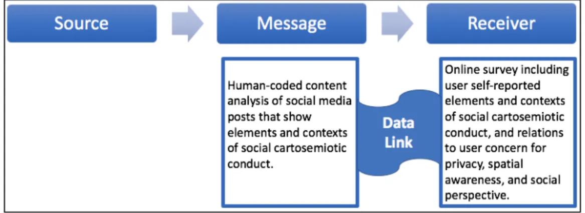
FIGURE 3.1: MàR DATA LINK EXAMPLE...41
FIGURE 3.2: 13-ITEM SCALE FOR GLOBAL COMPETENCE...62
CHAPTER 1. INTRODUCTION
From hand-drawn cartography, to Geographic Information Systems (GIS), to social media features, maps have always been a medium for users to seek information about their surroundings. This medium, print to digital, has advanced individuals’ ability to express and understand spatial awareness, as well as the context underlining each communicated space that relates to individual or communal social perspective. As digital modes of this media have expanded over time, priority and concern in sharing locations across online communication platforms have influenced how individuals view privacy and corresponding safety awareness. Although these constructs are relevant to the design and study of cartography, maps are mutually perceived as objective documents that strictly depict physical or geographical proximity.
However, if we examine a brief example of cartographic evolution from ancient cartography to mapping features in social media, map design and language present influential and multimodal communication. Literature in cartography and geography presents how participatory mapping and social cartography can influence respective users’ perceptions and behaviors (Pickles, 1995; Pavlovskaya, 2016; Lin, 2013; Van der Woude, 2008; Garfield, 2013; Wood, Kaiser, &
Abramms, 2001; Monmonier, 1991); and social media communication literature presents how respective users’ perceptions and behaviors are influenced (Fischer & Reuber, 2010; Turkle, 2012; Bryant & Oliver, 1994; Baran & Davis, 2013; McQuail, 2010); however, there is little explanation of the effects when these two realms of information communication combine in online spaces. This study strives to fill the gaps in literature between social media engagement and social cartography, and the overall goal of this study is to analyze a specific realm of social media behavior influenced by cartographic features and language.
1.1 Evolution of Cartosemiotics
Cartographic statements shift over time in order to adapt to societal changes (Garfield, 2013; Pickles, 1995), and some maps act as a vehicle of opportunity for certain groups in society to progress. Simon Garfield (2013) explains how ancient maps were created to adhere to the mind of their users. He elaborates how the first Mappa, c. 1290 (meaning cloth napkin in medieval times) was “a guide, for a largely illiterate public, to a Christian life” (Garfield, 2013, p. 43). This map, as an example of cartography of its time, was a decorative map that exhibited the Last Judgement, and the two sides of the map face showed contradicting settings: one of paradise, and one with demons and dragons. This use of monstrous semiology as placeholders for unexplored lands/seas directly inclined voyagers to demonize indigenous races within colonial literature (Garfield, 2013). Therefore, this map was a persuasive medium used to visually steer mediaeval citizens toward Christian culture through semiotics. Although
technology and global knowledge has advanced since c. 1290, symbols are still a foundational element in cartographic design (Peterson, 2015) and have simultaneously become more prominent in our means of Computer Mediated Communication (CMC) to amend the lack of visual cues.
The study of semiotics emphasizes the “relationship of signs or symbols (i.e. word, sound, image), their contextual meaning, and how the public or specific viewer(s) interact with such meaning” (Gaines, 2010, p. 7). Cartosemiotics is a specific realm of semiotics in which the signs, symbols, and corresponding rhetoric portrayed on a map is studied. This study will focus on cartosemiotics from the perspective of the following definition: “Map language from the standpoint of modelling, communication and cognition with the goal of acquisition of new
spatial knowledge or re-vitalization of forgotten spatial information” (Wolodtschenko, 2003, p. 1977). This study will also consider the following themes of cartosemiotics:
Map symbolism, or map language, that is, the type of sign systems that are manifested in individual map faces; marginal notes; peripheral signification phenomena; the process in which humans handle signs, or sign processes for short; the context in which signs and sign processes are embedded.
(Schlichtmann, 2003, p. 1)
Mapmakers used to be subjectively inclined to embed cartosemiotics that communicated their own biased context of the world, before global exploration and technology influenced a push for a more accurate, democratically accepted communication of the world. This bias is now driven by selective purposes that maps convey to specific audiences; “In geography, studies of
perception of environment, behavioral environment, and environmental cognition have come to enjoy increasingly popularity” (Porter & Lukermann, 1976, p. 198). Porter and Lukermann (1976) as well as Wood, Kaiser, and Abramms (2001) agree that maps are created with subjective conceptions to design unique experiences; specifically, “the study of geographical knowledge, or geosophy, covers the geographical ideas, both true and false, of all manner of people—not only geographers, but farmers and fisherman, business executives and poets, novelists and painters” (Porter, & Lukermann, 1976, p. 197; Wright, 1947). One of the goals of this study is to show that social media users belong in this list of people who are integral to the idea and communication of geosophy. Wood and colleagues (2001) further this cartographic selectivity by suggesting “we should have put ‘world map’ in quotation marks [because] every map serves a specific purpose [and] every map advances an interest...the name ‘world map’ is convenient but keep in mind that a great deal is missing [and] often what’s missing is a clue to the purpose the map is serving” (p. 4). Despite a shift in technology, maps are still made “of our experience patterns, as an inner model of the outer world, and [used] to organize our lives”
(Kepes, 1967, p. 67). Media communication scholars state that social media engagement and other forms of CMC are channels that also result from our collected experiences, or schema, and are used to express individual ‘models’, in order to understand or connect to the outer world.
This overlap reinforces that cartography is a social construct, but historical mapmakers’ hand in designing the world also proved society as a cartographic construct. Since ancient
cartographic design was usually in the hand of one or a few men, the information maps presented about viewers’ surroundings exuded hegemony that influenced how a world or culture should be understood, which affected societal perceptions and how one interacted/interpreted their
surroundings (Garfield, 2013; Van de Woulde, 2008). Even once technical approaches to modern mapmaking commenced, such as GIS, relative scholars like Pickles (1995) expressed that
cartography still contained this hegemonic visual rhetoric that resulted from manipulation of interpreted data. Furthermore, current maps are fashioned more accurately in terms of spatial representation across global landmasses with precise proportions, but all mapmakers still make decisions about what shall be mapped and what shall not be mapped. For example, contemporary maps can “represent unwieldly territories as tidy, governable units and, in so doing, [maps] function as political and ideological tools of empire” (Van der Woude, 2008, p. 1074). Monmonier (1991) also presents the truth about how cartography and advertising have commonalities due to their “need to communicate a limited version of the truth” (p. 58). For example, “advertising agencies serving airlines can have a great fun with maps, [as they] decorate maps with pictograms of impressive skyscrapers, museums, golfers, girls in bathing suits, and other symbols of culture or leisure...by manipulating maplike images” (Monmonier, 1991, p. 63). Monmonier (1991) also indicates that the same cartosemiotic strategies are
rhetorical ways. If we think about how social media accessibility is used by the public as a vehicle for political, ideological, artistic, and self-expression, a clear overlap in social media engagement and social cartography is apparent. The evolution of both cartographic expression and CMC indicates that cartosemiotics and social media engagement yield a rhetorical power that mapmakers and social media users have manipulated in different ways overtime, in order to portray the world according to political and cultural status or power.
Cartosemiotics have evolved onto new platforms that create a narrative of the surroundings in social media. In contrast to hegemonic cartography, social cartography has become more prominent, as technology has created more and different opportunities for individuals and groups to socially interact digitally. Since new cartography and GIS is based mainly in digital realms, cartography has inevitably been mediated by social interactions and in some cases cartography supports social interactions (Carvalho Di Maio, Gomes, & de Lourdes Neves de Oliveira Kurkdjian, 2011). Specifically, social cartography can:
Serve as a support to the social interaction processes and participative-action of most distinguished social agents on their way to a gradual reversal of the social alienation or lack of information processes, particularly to processes of political inequality and social and spatial segregation. (Carvalho Di Maio, et. al., 2011, p. 39)
For example, social mapping supports social interaction because users can create, add, and maintain spatial information and corresponding social or political contexts in their social media posts. Quiring (2015) notes that, within virtual interactions, “[people] apparently seek to
make...digital worlds behave more like the physical world, [and] the preference for proximity indicates a close relationship between the approximation of voice and social interaction” (p. 11). Even though individuals interact digitally in the online realm, they strive for tangibility by simulating real space or proximity in digital places. With mapping an increasingly social
phenomenon, a surplus of information about societal and worldly surroundings becomes easily and visually accessible on social media. For example, social media users can use platform features to geotag their shared pictures and/or posts, modify their shared content with more geotag variations by adding a hashtag and location (i.e. #FortCollins or #DownTown), and even supplement their geotagged posts using semiotic capabilities like Bitmoji or emoji. Emoji are contemporarily viewed as signs or symbols that present a meaning-making ability in online communication that transcends cultures and technical lexicon (Danesi, 2017). Bitmoji are an even newer version of these symbols that take on personable traits and identity as constructed by the user who shares them. Social media users’ ability to create and share symbols within online platforms communally changes and adds to map language. Other interacting users, in turn, engage in this communication via symbol creation of their own; therefore, I define this process as social cartosemiotic conduct.
1.2 Social Media and Cartosemiotics
Social cartosemiotic conduct (SCC) expands social media platforms in ways that prioritize the communication of spatial information in terms of physical location and context, and the optimization of the semiotics that platforms allow via emoji, bitmoji, and images. Specifically, Lin (2013) presents a study that reveals “special moments of mapping and the construction of spatial narratives” (p. 51) that can translate to the cartosemiotic narrative converging in social media messages. Digital media convergence was originally the process of digital media and technology displacing traditional and print media practices that placed demands on anyone who communicated information within their profession (Seel, 2012). Digital media transcends all traditional media and is now advanced and implemented to combine practices across disciplines, such as cartography and social media, to create new multimedia practices and theories.
Similar to the original digital media convergence, the idea of hypermedia continues to inspire and revolutionize media communications in how it augments different experiences as well as the real with unreal. Seel (2012) recalls witnessing hypermedia for the first time that visually and realistically portrayed of Aspen, Colorado, during the 1900s which was breathtaking to audience members—he states that “the map designers had created a multilayered, multimedia profile of Aspen that included [specific elements of the ski town] and the navigational map overlay” (Seel, 2012, p. 238). Moreover, we often relate the digital convergence and rise of technology to a powerful mediation capable of changing identity, society, the
marketplace/professions, etc.; however, this evolution in communication with digital media primarily advanced how we appreciated, understood, and visualized place. The new ability for society and scholars to communicate place and space in such intricate ways via hypermedia convergence changed how we place concern on privacy in location, as it has now become a controversial, yet desirable, setting on all mobile devices and feature on social media platforms. The degree of individual spatial awareness has also been tested by this prominence of sharing location on social media platforms, since users could potentially gather and analyze their surroundings from the comfort of their home, scrolling through social media feeds and posts relating to surrounding parks, schools, restaurants, businesses, etc. Since there is a possibility for this individual evaluation of spatial surroundings through a strict lens of social media posts, there is also a test for social perspective in how individuals rely on cartosemiotics in social media posts to confirm their biases, or make societal assumptions based on a collective social media movement that specifies the context of a location/place.
Furthermore, what has and still excites communication technology experts, according to Seel (2012), is the “vivid demonstration of the use of multiple layers of media to augment human
understanding of place and its history” (p. 238); the interesting addition to this demonstration is how normal individuals have become a part of this multi-media construction through social media platforms in order to define spatial and contextual place, as well as how it will be studied in future communication history.
Gunkel (2007) emphasizes many individuals who share different perspectives and knowledge in different disciplines all had this one similar concern for the digital divide, or—from Gunkel’s (2007) perspective— the idea of unequal distribution of information communication
technologies (ICT). This divide exists in critical cartography as well, since only individuals knowledgeable or interested in spatial relations will acquire proficiency in developing spatial communication technology. Since social media is a public domain that more and more countries are starting to acquire for information seeking and relationship building, it is a platform that provides features that allow users to cross digital divides from areas outside communication; for example, individuals might not have the access or ability to partake in social mapping or GIS skills (spatial ICT), but their understanding of hashtags in posts indicating location, and the efficiency of emoji symbols to add context, shows how cartosemiotics in social media
communication can be cross-disciplinary and overcome some digital divides. Sui and Goodchild (2001) add that GIS can be generally known as a mass media1 instrument now that it has
converged with social media disciplines. This spatial ICT “communicates geographical
information in digital form, [which] illustrates its consistency with contemporary media” (Sui & Goodchild, 2001, p. 388); in contrast, GIS is widely used to analyze spatial data, however, the overall goal of using this spatial ICT is to communicate information to large audiences (Sui &
1
Goodchild, 2001). As GIS permeates society as a communicative media, there have been connections made between GIS, parallels in cartography, communication theory, and even linguistic perspectives (Sui & Goodchild, 2001; Tobler, 1979; Frank & Mark, 1991) to discuss trends of language in GIS and cartography. This language has evolved to include location hashtags and emoji semiology on social media platforms through social cartosemiotic conduct.
In a study that examines this spatially semiotic communication online, Caquard (2014) concludes that “The cartographic content collectively produced via social media remains largely the expression of the values of a relatively small number of contributors with technological ability” (p. 146); however, if we view the production of cartographic content as speaking a language, rather than creating a literal map face, there is a large number of contributors who have the capability of sharing their spatial and cultural knowledge of a given space using common social media features like hashtags and emoji (and symbols alike) to communicate cartographic content. Similar to Caquard (2014), Haklay (2013), represents another side of critical
cartography by criticizing how, rather than empowering the masses, user access to contemporary cartographic technologies has only “opened up the collection and use of this [geo]information to a larger section of the affluent, educated, and powerful part of society” (p. 66). The scope of this study genuinely aligns with this statement, as mapping technologies like Google Earth and Open Street Map—despite their demonstration of social cartography: being easily accessible and promoted with an element of social interaction—will likely only be sought by socio-groups with the interest and knowledge that this software catalyzes. I argue, however, that in order to study social mapping in a more efficient and generalizable way, there is a need to analyze social mapping and social cartosemiotic conduct on platforms that are accessible to all demographics. These platforms do not need to be highly advanced in GIS or cartographic capabilities; rather,
such platform should allow for literal or allegorical neogeography. Turner (2006) expresses that “neogeography is about people using and creating their own maps, on their own terms and by combining elements of an existing toolset...[it] is about sharing location information with friends and visitors, helping shape context, and conveying understanding through knowledge of place” (p. 2). Accordingly, this study strives to fill this gap in understanding the benefits of
neogeography from the standpoint of socially constructed and communicated map language, (through use of geotags #[location] combined with representative semiology in the form of emoji) that, I posit, is representational of literal neogeographic maps. After all, cartography communicates a narrative of space and culture that transcends multiple media, and social media platforms and features set the perfect stage and existing toolset for this language.
1.3 Need for Research
Around 2005, when internet mapping was becoming more popular due to advancing technology for geospatial information customization online, “the services were limited to information preloaded by the provider and allowed little customization by end users” (Haklay, Singleton, & Parker, 2012, p. 2015). With the advancement of new technology in social media and cartography, geotagging and semiotic interplay with emoji and bitmoji has become a common social phenomenon that is highly customizable. It allows social media users to have more interaction with mapping concepts, like cartosemiotics, and reveals a new aspect of CMC (computer mediated communication) that might alter what we know about behavior in online spaces and how this affects user perceptions. Table 1.1 below outlines the elements that work together to create SCC in computer-mediated communication. This study adds to the
understanding of this social media use that is influenced by mapping features on various online platforms.
Table 1.1
Elements that Distinguish the Nature of SCC
Platforms Geotags Symbols Contexts
Twitter #[location] Emoji Model/communicate spatial
knowledge Instagram Geotagged coordinates
(Add/share location option for posts)
Bitmoji
Re-vitalize forgotten spatial information
GeoFilters
Picture
Share users’ inner model of the outer world
SMS Messenger Gif
SnapChat
Furthermore, social cartography allows users a more well-rounded view of their
surroundings, but this is also potentially problematic, since social mapping could lead to another outlet for confirmation bias of spatial and social information, similar to such in media
communication and social science research (Knobloch-Westerwick, Mothes, Johnson, Westerwick, & Donsbach, 2015; Nickerson, 1998). According to Tobler’s First Law of Geography, which was written in 1970 and defended again in a 2004 forum, “Everything is related to everything else but near things are more related than distant things” (Tobler, 2004, p. 304). This also promotes that in an era of easy and inexpensive global travel, things—such as travel planning and distant cultures— can be studied easily through cartosemiotics. Therefore, it is possible that, like users seeking information in media, individuals will seek out geotagged information that is close to them physically/spatially, in addition to seeking out spatial
information that reflects their own biases and opinions. Cartosemiotics on social media has and continues to nudge individuals to regularly self-disclose location, which is starting to redefine laws and social norms of privacy; for example, almost all mobile devices are required to be
geographically enabled (Sui & Goodchild, 2001), and users commonly prefer to set their location settings on in order to filter their mobile internet searches, GPS navigation, coupons and deals within the range of their exact surroundings according to location-tracking and position-aware location-based services (Barkuus, & Dey, 2003; Unni & Harmon, 2013) his research is needed to highlight these concerns of online communication of space and allude to solutions or suggestions to be considered in user experience/interaction (UX / UI) in practical realms of social media platform re/design.
1.4 Purpose and Research Questions
This study seeks to describe the existence of social cartosemiotic conduct on specific social media platforms, and analyze how this conduct is self-reported by, and hypothetically affecting, social media users. The fundamental theories that inform this study include
cartosemiotics, sociocultural theory, self-disclosure, and communication privacy management theory. These theories, with the exception of cartosemiotics, are primarily from a communication research standpoint; however, this study posits that there are congruencies in cartographic
communication and social media engagement, which will reflect theoretical overlaps. These theories will help inform the behavioral aspects of social cartosemiotic conduct and how this behavior effects and/or reflects societal communication practices and understanding as a whole. The overarching questions driving the goals of this study include: (1) What is the interactive nature of social cartosemiotic conduct on social media platforms that have adopted mapping technology? (2) Consequentially, does this conduct affect individuals’ spatial awareness, social perspective, and/or concern for privacy? Through an extensive literature review analyzing the convergence of media communication and cartography, as well as a proposed multi-quantitative method, this study will strive to answer these questions.
CHAPTER 2. LITERATURE REVIEW
2.1 Hegemonic to Social Media: Cartography and Online Platforms
Before the Geographic Information System (GIS) and Web 2.0, communicating location and place was not as easy and accurate as dropping or sharing an instant ‘Pin’2 on a mobile device. Cartography and geodesy3 have always been grounded in mathematics and seek to be unbiased; however, with limited technology and circumnavigation in historical contexts, representative symbols on maps were used as placeholders to communicate space and navigate different cultures. Now, this form of geo-communication is more representative in descriptive, informal posts about vacation, travel, or place on a social media feed.
Ancient maps were highly subjective and only fashioned by affluent individuals, commonly men, who used hegemonic cartography to situate the political, geographical, economical, and social boundaries of a place (Pickles, 2000; Carter, 2009; Barreneche, 2012; Haklay, 2013). Hegemony is a cultural or economic understanding of surroundings resulting from societal leaders’ ability to accentuate their bias perspectives on the masses (Artz &
Kamalipour, 2003). Hegemonic cartography outlines this principle from historical mapmakers’ perspectives, as they were the leaders in designing the world façade. These artistic maps did attempt to implement mathematical practices, such as Cartesian space coordinates, to logically present a worldview; however, these practices were not consistent with an accurate
representation of the world, and portrayed more spatial experience in the eyes of the mapmaker,
2
“A term to describe your location on Google Maps. A feature of Google Maps allows users to locate a place on a map then drop the pin icon on that area. Users can then add a title and description before saving the location in their personal ‘My Maps’ area” (Beal, 2017).
3
rather than a logical spatial representation. This misrepresentation stemmed from a series of misunderstandings of semiotic use that supplemented the Cartesian abstraction; the graphical rendering in spatial symbolization narrowed the scope to audience interpretation for
understanding the world (Casti, 2015). Fast-forward to an advanced technological age, and maps are designed according to more accurate coordinates based on spatial algorithms using technical computer software, GIS capabilities, and consistent symbolization.
This contemporary practice might seem more logical in its representation; however, representing space using grids and coordinates, or Cartesian geometrics, has manipulated the representation of accurate cultural experiences in order to prioritize bureaucracy and capitalism (Wilmott, 2017; Sadler, 1999; Carter, 2009; Pickles, 2000, 2004; Dodge & Kitchin, 2013; Monmonier, 1991). In order to maintain a balance between portraying cultural experience and objective physical representations, neogeography was implemented as social mapping to allow for a democratized cartographic process. Some scholars are critical toward the benefit of this practice, but Turner (2006) expresses that neogeography is about people using and creating their own maps, on their own terms and by combining elements of an existing toolset...[it] is about sharing location information with friends and visitors, helping shape context, and conveying understanding through knowledge of place” (p. 2). The evolution from hegemonic to social cartography shows how audiences and media users have progressed to a point where they want to be a part of creating the information that is sought by others, rather than blindly following what is communicated by others.
Similar to the evolution of cartography, media communication was originally in the control of few dominating powers with the affluence and social status to maintain media content (Baran & Davis, 2013; McQuail, 2010; Turkle, 2012). This hegemonic capability was debunked
after social media began to take rise after the integration of Internet and information
communication technologies in society; however, some scholars shifted their critical focus to technology as a hegemonic power (Turkle, 2012). Similar to how technology dictated the
limitation in which mapmakers could represent our world, technology dictated the boundaries in which people could create and perform within that worldly representation. As digital
communication media converge with other discipline technology, these “new media technologies have the potential to re-orient us and, by extension, radically intervene in our understandings of place—specifically the public spaces of the city—and our places in it” (Verhoeff, Cooley, & Zwicker, 2017, p. 299). The cartosemiotic ability that social media technology mediates allows users to convey place in terms of spatial awareness, or relating social context, which can attribute to a more commonly known process deemed ‘technological determinism’ in which “the point to understand [is] how far technology does or does not condition social transformations” (Gunkel, 2007, p. 19). The growing prominence of semiotic language in online communication (Danesi, 2017) and categorization of place and social components, is due to the influence of emoji and bitmoji symbols promoted in social media technology in addition to the social desirability of hashtag use dictated by technologically-mediated communication, or computer-mediated communication (CMC) theory.
2.1.1 Information Seeking: Cartosemiotics and Media Communication
In the physical realm, geographical proximity is the quantifiable distance between people, societies, and land; this proximity exists in a cartographic sense like cross-country or across the street, which can be understood through map models as they visualize this tangible proximity. This is the spatial information that is commonly sought for purposes of navigation and travel. Recently, however, geographic proximity is also understood in the invisible realm due to
technology that allows people to map and/or access virtual realities; “maps have become interactive to the point that they are co-produced by their users... [and users are] constantly influenc[ing] the shape and look of the map itself” (Lammes, 2017, p. 1020). The integration of technology in spatial information seeking has changed how we determine place and space. Mobile devices provide instant, real-time access to direction suggestions according to nearby traffic, road construction, in order to predict how distant places are from any given location. The way mobile technology presents this spatial information also mediates cultural influences based on location; for example, when a user searches a city on Google Maps’ online platform, the geographical proximity and boundaries of the city is presented, as well as corresponding weather, hotel and restaurant reviews, facts about the community, and pictures of the best areas in that city. Moreover, technology and media platforms have expanded spatial information seeking capabilities to include foreign countries and cultures in order to help shape well-informed perceptions. How people come to understand the world around them includes this spatial information seeking through various platforms; specifically, “how people perceive space and time, and, subsequently, how they refer to these, is the subject of naïve geography, defined as ‘the body of knowledge that people have about the surrounding geographic world’”
(Egenhofer & Mark, 1995, p. 4).
This information seeking and analysis used to be more interpretive in pre-GIS
mapmaking; for instance, symbols and map-face design were not consistent across assorted maps (Pikles, 1995; Carter, 2009). Cartographers chose symbols and design that they believed
coordinated with the culture and location of the land—which of course varied among land. For example, Figure 2.1 portrays the medieval European Islands with pictorials that show colors, animals, and monsters that subjectively portray the cultural tone of each landmass.
Figure 2.1: Map of medieval Scandinavian islands
This interpretive nature of maps was disadvantageous due to subjectivity and
cartographer bias (Pickles, 1995; Carter, 2009; Garfield, 2003), which prioritized the depiction of cultural experience and power at the expense of physical, spatial accuracy (Pickles,1995;
Garfield, 2003); although, compared to contemporary maps that are consistent in design and convey objective language, the historical maps actually convey spatial information that is more accurate. For example, contemporary maps, such as Google maps or GPS alike on mobile devices, leave absolutely no room for interpretation or spatial information related to differing cultural experience. This limitation to spatial information seeking has been examined by many scholars who study critical cartography. For instance, Wilmott (2016) states that Carter’s (2009) assessment of critical cartography becomes complicated when he stresses a need for immediacy of simultaneous movement and representation, and Wilmott (2016) furthers that mobile mapping is the answer, as it “engages a divergent set of movement practices, ones that not only respond to
325). My study extrapolates on this progression, by arguing map language, or Cartosemiotics, is more potent than mobile mapping in providing simultaneous movement and representation on social media platforms accessible by the public. Geographical or cartographical information is no longer bound by the limitations of a map-like interface; a message that contains elements of cartosemiotics (geotag and a symbol), translates a replica of messaging that emerges from a literal face of a map. This renovates how information seeking is defined in cartography, as map language can be created and accessed on cartographic platforms, as well as social media
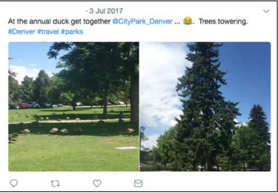
platforms. In Figure 2.2, we can see how the combination of a geo-hashtag and emoji can express spatial awareness, and meet the cartosemiotic context: Model/communicate spatial knowledge.
Figure 2.2: Tweet Showing Social Cartosemiotic Conduct
This tweet is conveying the poster’s spatial awareness by sharing his/her view of a place in Denver. He has coupled #Denver and an emoji from the lexicon category Smileys & People to combine elements of cartosemiotics and portray a semiotic emotion attached to a geotagged
place. This example of modeling spatial awareness/knowledge on Twitter adds to the social spatial awareness/knowledge of the city of Denver. In addition, as seen in Figure 2.3, the geo-hashtag emoji combination expresses social perspective, as well as the cartosemiotic context: Shares user’s inner model of the outer world.
Figure 2.3: Instagram Post Showing Social Cartosemiotic Conduct
This user on Instagram indicates a piece of their life in respect to a greater geographic whole, or Denver, by including geo-hashtag #milehighcity. S/he has also combined emojis from the lexicon categories: Food & Drink, Animals & Nature, and Smileys & People in order to
symbolize their inner model of the outer world. This individual example of social cartosemiotic conduct portrays a social perspective of Denver (the Mile-High City), as the user connects the semiotics of his/her healthy, happy lifestyle to the characteristics of this geographic location, adding to the overall social perspective of Denver.
Another specific example of cartosemiotics in social media information seeking is related to diasporic audiences in western culture. Media posts from western lenses evoke “memories of the homeland ... while simultaneously creating anxieties for these viewers by emphasizing their geographic and cultural distance from their homeland…as a result, they were reminded that they were cultural ‘Others’ in relation to [their] contemporary [homeland]” (Somani & Doshi, 2016, p. 5). This shows how communicating space and place through communication media can lead to strong social perspective influences, and therefore change the accuracy of information sought online.
2.1.2 Visual Rhetoric: Cartosemiotics and Social Media
Both fields have advanced an interest in visualization. Mapmakers and social media users always want more accuracy when communicating or viewing information. Map visualization in the early digital age and earlier had limited colors to use on maps until there was an explosion of color used to portray specific information spatially. Similarly, emoji have evolved from yellow round faces that express general emotion to gender, race, and cultural-specific emoji that portray accurate skin color, hair, offline physical expression, etc. Retrospectively, similar to the
misinterpretations that occur from rendered cartographic symbols, the colors and shapes of emoji present their own cultural biases on social media platforms.
Accessing and creating spatial information expressed via map language, or cartosemiotics, is not strictly text-based. Cartographic studies overlap with the physical realm of geographical proximity, as “Cartography describes places and spatially distributed phenomena graphically, using a system of (cartographic) symbols” (Enescu et. al., 2015, p. 224) that can be quantified. Cartosemiotic research incorporates elements of figurative proximity and how symbols and data visualization through maps share close or distant relationships with culture and individual viewer
schema. These symbols, which vary among different platforms from Bitmoji on SnapMap, to Pins in Google Maps, provide distinct context that can be viewed from a persuasive angle. The visual rhetoric entrenched in these symbols exudes a persuasive context and purpose of the spatial information; for example, Bitmoji on SnapChat are personalized to reflect the identity of each user, so this real-time symbol anthropomorphizes the map on SnapChat by providing unique human identity and performativity, rather than consistent symbols and objective lines that provide no variance in spatial-cultural experience (See Figure 2.4).
Figure 2.4: An example of Bitmoji symbols on SnapMap. Reprinted from Why advertisers should pay attention to Snapchat’s new maps feature, by A. Heath, 2017, from
http://www.businessinsider.com/how-snapchats-snap-maps-feature-could-be-big-for-advertisers-2017-7
In a way, these social media features that allow for cartographic visual rhetoric are creating a feedback loop back to interpretive style maps, while still trying to balance physical, spatial accuracy. Carter (2009) alludes to this visual rhetoric that cartosemiotics possess, insofar to examine how lines on maps dictate a certain rhythm that drives the context of its
representation, but it cannot exist in solidarity without the addition of public/cultural experience and interpretation. Specifically, Carter (2009) states:
The lining, which is simultaneously the rhythmic geography underwriting the map and... motion of the public coming together in public space, is stitched into the garment of representation, but it does not adhere to it completely...This becomes important in discussions about the relationship between representations and the world they seemingly represent. (p. 14)
This literal lining underwriting the map that also converges people in a space can also be viewed as a metaphor relating to specific language that determines cartosemiotics; for example, hashtags such as #[location] are geotags that are the foundation of map language on social media, but do not adhere to spatial representation completely without contextual symbols like emoji. There are neogeographic platforms that allow users to add to the visual rhetoric of a map, but I contend that interfaces that allow users to add to cartosemiotics, rather than—or in addition to— a physical map itself, is just as persuasive and spatially informative. Relatedly, Lammes (2017)
intellectually concludes that “cartographical interfaces invite users to a higher or lesser degree to give input that changes the map image and puts users in the map (p. 1029); furthermore, I
extrapolate that cartographical interfaces, particularly ones provided by social media features, invite users to give input that changes map language and puts users at the forefront of this vernacular.
2.1.3 Semiotic Convergence of Social Media and Cartography
Symbolic features used in social media, like emoji, bitmoji, and images attached to posts mimics the idea of animating data, which involves temporal proximity that “feature[s]
animations [that] show change over time or space, enabling audiences to track variations in data through motion—across a map, scatterplot, or other plotting area” (Kostelnick, 2016, p. 123). These affective symbols that create context and meaning in social media communication are relatable to ancient map semiotics used to convey bias cultural boundaries. Therefore, this study posits that there is a semiotic convergence from ancient map symbols to the emoji lexicon. Emoji
and Bitmoji are social symbols used in online communication that promote or supplement emotion in online messaging and sharing, as well as convey affect (Riordan, 2017; Desani, 2017). “The use and type of emojis has increased in recent years; particularly emojis that are not faces, but rather objects” (Riordan, 2017, p. 549), that do not portray emotion, but are commonly used to maintain and enhance social relationships or provide context to a shared message
(Riordan, 2017).
The semiotics component of cartosemiotics in social media is highly important, as map language cannot exist solely on a geotagged post. How we model our opinions and thoughts online are derived from a symbol system interplay across disciplines. Csanvi (1998) outlines this phenomenon clearly, which can be understood in a cartographic and social media perspective:
Our models of the living system can use abstract components, even semiotic interactions, but they are products of the human mind with which we try to simulate reality. Meaning exists only in our own mind. Society can also be modeled in a semiotic way, but we know from our everyday experience that the organization of society is based on a great many unreliable components, and the self-organization of society uses only some of these properties. (p. 260)
When coordinated with a geotag, or specified location, a symbol can contextualize a place. Humphreys and Liao (2011), analyze geotagging, specifically via mobile technology, as a social practice, and examine geotags (on the platform Socialight) as “adding ‘virtual information’ to a physical location by leaving virtual sticky notes around a city” (p. 408). This relates to the practice of including #[location] on social media posts that virtually specify physical places in cities and beyond. As of today, #nyc (New York City) and #london are both rated in the top 100 most hashtagged words on social media, which means people are taking this geotagging ability from earlier platforms like WikiMapia and OpenStreetMap, and replicating that experience in social media posts. Barreneche (2012) promotes that “this increasing and seamless integration of geocoding into our everyday communications may make location a default protocol setting of
communication, and soon a taken-for-granted dimension of our media experience, to the point of rendering the prefix ‘geo’ in geomedia superfluous” (p. 332). Comprehending the social media use of #[location] can be difficult, since—like the use of emojis—hashtags can carry underlying meanings or tones subjective to the sharer because hashtags “perform an implicit emotive or emphatic function in addition to [their] topic tagging function” (Wikström, 2014, p. 134). For example, it can be difficult distinguishing between a hashtag as a literal location and a hashtag portraying themes of sarcasm, since “these tags make attitudinal additions” (Wikström, 2014, p. 140) to social media posts. Teasing the differences in tones with the use of #[location] and emoji could prove extremely interesting results to explain social media users’ motivations for social cartosemiotics; however, this study’s analysis is merely looking at the literal presence of combining geo-hashtags and emojis in social media, or how recipients/viewers of these posts would read them at face-value. Once the presence of social cartosemiotic conduct is defined in this study, future studies will be planned to further distinguish social cartosemiotics from the posters’ perspective; for example, if their use of emoji and #[location] is meant to be sarcastic, humorous, informative, propagandist, etc.
2.2 Critical Cartography and Media Communication
Critical cartography and GIS studies will propel this research because this cartographic system, although technical, uses different algorithms that are used in strategic ways to
accomplish a specific view of land, space, or shopping malls showing how map language is not just informative, but influential and culturally persuasive; for example, Pickles (1995) examines this manipulation and interpretation of data and explains how mapmakers/GIS programmers have hegemonic power. This lens will be used to analyze how this power is relevant when social
media users engage with social cartosemiotics wherein there are multiple users interacting with and creating on a map, rather than few programmers creating the spatial information.
Carter (2009) writes that cartographers and GIS programmers are “agents of symbolic transformation, [who] have signed up to the cult of smoothness, from which every wrinkle of time has been airbrushed” (Carter, 2009, p. 2). Critically, his research posits how there is a need for honesty in cartographic representations to truly create documents— “and the future history they inaugurate, of colonization, territorialization, and authorization of new political and social order” (Carter, 2009, p.3)— that communicate an accurate narrative of space and time.
Other critical scholars share the same passion as Carter, promoting how, for example,
“cartographic information is derived not from the world in some pure and unmediated form, but is constrained by the parameters of capture technologies and altered through the lens of what is deemed important by cartographers and their paymasters” (Dodge & Kitchin, 2013, p. 31). Although it is assumed that hegemonic mapmaker bias concluded with the rise of technology, the reality is the technical and objective façade that technology exudes is merely masking this
hegemonic cartography in our modern era. For example, when Carter (2009) characterizes map design language through discussing the history of a line, and how the rhythm of using lines, and its reconceptualization, is what influences this map design language; he further discusses how “Modernists spiritualized or dematerialized the line in an attempt to represent essential forces, but the movement attributed to their lines remained linear...There was little sense that the line had a history, or, as we might say, lining, that it was formalization of a field of traces rather than the outline of a past, present, or future object” (Carter, 2009, p. 14). Mapmakers attempted to convince a more meaningful interpretation behind the use of lines on contemporary maps;
however, although this seems naïve, lines are inherently linear, and cultural experiences contextualized in spatial information do not exist in straight-line patterns.
Since critics posit that contemporary map images lack the necessary portrayal of cultural experience in space and time, an important question accumulates in Wilmott’s (2016) research:
Can we live with maps differently? —With the phenomenon of geo-locative and Global Positioning System (GPS)-enabled technologies, can we find ways in which to express a cartography that engages movement and expresses motile experiences meaningfully, without being reduced to repetitive and generic representation? (p. 321)
Wilmott (2016) concluded in his study that “in-between mobile maps and media, an invisible breadth of perception sits...and shows that indeed, maybe, we can live with our (mobile) maps differently” (p. 333).
My study attempts to fill this gap of invisible perception through promoting the dominance cartosemiotics in social media and online communication. Critical cartography examines maps in abstract ways; however, the majority of this research stems from the image of the map itself and what and how the image communicates; if the map language is explored as a representation of visual rhetoric from map image, we can see how individuals can live with cartography differently by engaging with different elements of cartosemiotics (geotags, #[location], emoji, bitmoji, etc.) to express and understand unique spatial experience. 2.2.1 Spatial Awareness
This study frames spatial awareness in the scope of Bolton and Bass’s (2007) study, who define the term according to three levels of awareness:
Spatial awareness (SpA) is an aspect of situation awareness (SA) that
encompasses the extent to which a person notices objects in the environment (Level 1), his understanding of where these objects are (Level 2), and his understanding of where they will be in the future (Level 3). (p. 2582)
This variable of critical cartography and critical social-cultural communication is a key element to this study as it pertains to spatial information seeking and expression through cartosemiotics on social media, as well as how one situates oneself in according to objects and understanding of one’s surroundings. Edward T. Hall (1990) examines this phenomenon in a more theoretical lens, explaining how, why, and to what degree individuals situate themselves in a given space
physically or cognitively. Social media platforms allow users to cognitively situate themselves in a space, and now with the prominence of location-based sharing and social cartosemiotic conduct (SCC), users can in a sense share online how they physically situate themselves offline. This might impress the opinion that SCC allows users to further establish a sense of place; however, scholars like Lammes (2017) reference other critical cartographers and media scholars who emphasize that, “in relation to space, scholars even argue that new media deprive us of a sense of place. Through their global and ubiquitous use and through representations, they are said to create ‘geographies of nowhere’” (p. 1022). In order to map this spatial awareness or geography of nowhere, “people use mobile geotagging to coordinate social movement” (Humphreys & Liao, 2011, p. 418) and contextualize this placement with semiotic meaning. This study will further the critical discussion on how SCC and other forms of cross-disciplinary CMC helps or hinders user spatial awareness.
2.2.2 Social Perspective
As stated by Wilson and Boyer et. al. (2008), “Proximity is not only based on the number of kilometers separating them, but also on the individual’s perception of this physical distance;” (p. 981) it involves relational or social proximity and “it involves much more than ‘being there’ in terms of physical proximity” (p. 982). Furthermore, social media posts that portray social cartosemiotic conduct is related to Stefanidis et al.’s (2013) study on community building in
social media merged with cartographic considerations, in which they determine “a new perspective to geopolitical boundaries, showing how the world is structured and connected despite its political boundaries rather than because of them” (p. 126). Overall, social
cartosemiotics is a vehicle for establishing individual and communal social perspective online, which reflects “one of the goals behind location-based services creat[ing] more contextualized communication” (Humphreys & Liao, 2011, p. 420).
In order to focus the complex construct ‘social perspective’ to a measurable resulting variable of SCC, this study adapts a modernized version of Hett’s (1993) definition and scale of Global Mindedness, derivative of Sampson and Smith’s (1957) worldmindedness, to reflect social perspective; Hett’s (1993) definition of Global Mindedness is as follows: “A worldview in which one sees oneself as connected to the world community and feels a sense of responsibility for its members. This commitment is reflected in attitudes, beliefs, and behaviors” (p. 143). Morais and Ogden’s (2010) modernized Global Mindedness to Global Citizenship, which takes into account three different dimensions constituting its definition in their study: social
responsibility, global competence, and global civic engagement. Social perspective, as a result of CSS, encompasses the same understanding of the global competence dimension of Global
Citizenship, which will be further operationalized in the methods section of this proposal. 2.2.3 Concern for Privacy
As technological advancements continue to create new opportunities and platforms for individuals to share and seek information, privacy has become a key factor in almost every dimension of public communication research and industry. Major tech businesses, like Google, Microsoft, and Apple, have teams of employees who strictly focus on addressing privacy concerns in user experience research. For legal reasons, their products all users to “create
deterministic rules specifying which part of the content will be shared, and to whom the content will be accessible” (Liang, Shen, & Fu, 2017, p. 1477). However, Liang et. al. (2017) emphasize that “privacy is a culturally specific phenomenon,” (p. 1476) and the permeation of technology in daily lives propels cultural change. Furthermore, individuals are spending more time building relationships and seeking information in online realms in order to build what now seems to supersede privacy: social capital. For example, “Concerning individual-level factors, the number of followers and the number of followings exhibited different effects on privacy protection [; for example,] having more followers indicates higher probability of geo-disclosure” (Liang, et al., 2017, p. 1489) because “users are motivated to self-disclose for building social capital” (Choi & Bazarova, 2015).
Due to the synergy of cartosemiotics and social media engagement, over half of the information shared in online platforms is location-based. One of the questions that this study alludes to is the self-reported concern for privacy to see if individuals are less concerned due to social capital gain, or if they are truly unaware of how invaded their mobile/online information is. Wilmott (2016) reminds that any content from mobile devices is always, subtly or
confidently, geotagged with location and time data. Specifically, tech companies acquire this data to drive their market and user research, or sell this geotagged data to other marketing
companies for profit, “implicitly spati[al]temporalizing media according to the cartographic logic of the map” (Wilmott, 2016, p. 321).
2.2.3.1 Self-Disclosure. Privacy settings and cautions that act as nudges on mobile
devices should influence users to share information with a sense of awareness and restraint; however, studies show that users use this ‘control’ of their privacy as a scapegoat to disclose more personable information (Liang, Shen, & Fu, 2017; Stutzman, Capra, & Thompson, 2011).
As privacy becomes less of a concern in light of building social capital, self-disclosure becomes more prominent in online platforms and has actually become a social media norm. In order to acquire more followers and likes on a post, self-disclosure is key because users become more relatable when they disclose more information—and the one piece of information that all unique individuals can always relate to in some way is place or location. For instance, even though Twitter gives its user an option to disclose their tweets to the public, or to customized viewers, “Twitter users are more likely to include location information when tweeting about offline activities” (Liang, et al., 2017, p. 1481). In order to engage in social cartosemiotic conduct, individuals must be at least somewhat comfortable self-disclosing the location and
context/opinion of a given place; therefore, this type of online communication research will inform new elements of disclosure, and will add to the understanding of privacy and self-disclosure in cartographic user experience.
2.2.3.2 Communication Privacy Management Theory (CAPM). CAPM theory posits
that “privacy boundary draws the line between private information and public information [, and] individuals create and apply rules to manage if and how information will be shared or concealed” (Liang, et al., 2017). This theory informs this social cartosemiotic conduct study, as the user communicates information online within their determined privacy boundaries. For example, a user might share a post consisting of #starbucks #fortcollins with a coffee emoji and smiley emoji, but she will choose to manage the time in which she shares that self-disclosed
information. If a user shares this before or while she is sitting in the Fort Collin’s Starbucks, she is less likely to be concerned with the privacy of her location to the public; the analysis would be different if the individual shared this after leaving the shared location, as this would
hypothetically indicate user concealment of current location representing their real-time privacy cognizance.
2.2.3.3 Concern for Information Privacy Theory (CFIP). CIFP is more of a construct
than a theory, however, it was developed as an instrument (15-item scale measuring concern for information privacy) by Smith et. al. (1996) which has been used to measure the concern for privacy employees had in the workplace considering advancing technology and Internet (Stewart & Segars, 2002). Smith et. al. (1996) evaluated information privacy from three dimensions including information collection, information management, and secondary use. Although these dimensions were used to reflect strategic communication and company privacy for employees, the same characteristics can be applied to ‘computer’ or ‘online platforms’, rather than their constant variable ‘company’. The way social media users share, collect, manage, and use their self-disclosed information defines the properties of online communication, and, specifically, social cartosemiotic conduct. Gordon’s (2007) research adds an important consideration of commodification to CAPM and CIFP; he establishes:
While the ability to locate oneself and one’s data within global networks is potentially empowering, it also transforms the everyday into a product. The cost of locating oneself within digital networks is being located within those name networks—not as a person, but as a commodity, as data. (p. 898)
His statement addresses that lack of privacy management and concern results in simulated empowerment; in addition, users might gain a feeling of social capital, but the reality is that their shared data is more of a monetary gain for media, marketing, and tech companies.
2.2.4 Sociocultural Theory
The fact that individuals are hypothetically more likely to live with maps differently through social cartosemiotic conduct, rather than creating and manipulating a map image, emphasizes a social-cultural inheritance in which “they are fascinated by processes rather than
structures. They do not want to know the world and to reflect on it; they want to invent it, manipulate it” (Carter, 2009, p. xiii). Sociocultural theory in communication stresses that the way humans search, understand, and use information is mediated (Lantolf, 2000); this mediation allows humans to interact with and add to the world by using “symbolic tools, or signs, to mediate and regulate relationships with others and with [them]selves” (Lantolf, 2000, p. 1) This semiotic engagement can be specified in cartosemiotic elements that individuals can implement in social media spaces to communicate their understanding of the world (or place) and where they exist in that space. Furthermore, referencing cartosemiotics in this case is highly relevant to sociocultural theory, as Lantolf (2000) stresses that “among symbolic tools are numbers and arithmetic systems, ... and above all language... [which is used] to establish an indirect, or mediated, relationship between [individuals] and the world” (p. 1). This theoretical lens exemplifies how cartosemiotics, or map language, should be used in conjunction with the
technical symbols and algorithms of contemporary mapping images in order to better understand and represent perceptions of the world culturally and spatially.
This mediation of symbols and cartographic language correlates with our computer mediated communication via “mobile technologies that have contributed to new social and cultural practices: practices that produce and sustain communities, practices that have a fundamental impact on our ways of representing the world around us and understanding our place within it” (Verhoeff, Cooley, & Zwicker, 2017, p. 299). Social cartosemiotic conduct that exists on social media platforms is an ideal example of how individual communication on space and time is mediated by symbols and technological features to express unique representations of the world, and view other representations to impact their own understanding of place. In contrast, easy access to online mapping and map language, without dictated perception, would seem to