http://dx.doi.org/10.4236/eng.2016.83015
Hydro-Politics of the Tigris and
Euphrates Basins
Nadhir Al-Ansari
Luleå University of Technology, Luleå, Sweden
Received 1 March 2016; accepted 25 March 2016; published 28 March 2016 Copyright © 2016 by author and Scientific Research Publishing Inc.
This work is licensed under the Creative Commons Attribution International License (CC BY). http://creativecommons.org/licenses/by/4.0/
Abstract
The supply of fresh water is essential to life, socioeconomic development, and political stability in Middle East. Turkey, Syria and Iraq are the main riparian countries in the Tigris-Euphrates basin. Turkey is the riparian hegemon for a long time due to its structural power and dominant river po-sition. Iraq and Syria are the lower countries in the basin and for this reason they always like to ensure the quantity of water required to satisfy their requirements. The conflict between riparian countries is due to several factors. These are: population growth rate and food security, energy security, economic and technological development, political fragmentation, international water laws, water and management availability and public awareness. There have been a number of at-tempts to find a common ground on water issues between the main three riparian countries since 1920 but no agreement signed yet. Present situation is very bad in Syria and Iraq where thousands of people have no access to water and farmers are leaving their land because of draught. Such sit-uation will definitely raise tension and might lead to war. To avoid this, a mediator that has the capability to bring all countries concerned to the negotiation table is required. In addition, Syria and Iraq are to adopt prudent strategic plan based on resources development theory to ensure good water management and minimum water loses.
Keywords
Tigris, Euphrates, Hydro Politics, Iraq, Turkey, Syria
1. Introduction
The Middle East is characterized by its water shortage problem [1]-[5] where at least 12 countries have acute water scarcity problems with less than 500 m3 of renewable water resources per capita available [6][7]. The supply of fresh water is essential to life, socioeconomic development, and political stability in this region. In 1985, UN Secretary General Boutros Boutrous-Ghali said that the next war in the Near East would not be about
politics, but over water [8].
Sumerians occupied southern Mesopotamia since the dawn of civilization about 8000 years ago. Mesopota-mia’s plentiful water resources and lush river valleys served as the basis for the civilizing started at Sumer. In that region Sumerians invented the first form of irrigation to improve agricultural production on the lower Me-sopotamian Plain. They also devised the first written communication, or handwriting. This work continued through the time of other rulers like Hammurabi (1792-1750 B.C.), Cyrus (550-530 B.C.), Darius (520-485 B.C.), Alexander (336-323 B.C.), and the Abbasids (750-1258). The Assyrians in 754 B.C. used the rivers for transporting grain while also deepening and straightening many of the existing canals. For this reason it is called the hydraulic civilization. Despite its productive wealth and prosperity for many millennia, Mesopotamia saw wave after wave of conflicts. This can be noticed through the myths, legends and historical accounts that sur-vived from earlier times e.g. Epic of Gilgamesh [9]. Dispute was over access to water supplies or international attacks on water supply systems during wars [10]. Another example of such wars is the invasion of the Mongols in the thirteenth century, destroying a majority of elaborate canals systems built centuries before. After that until the nineteenth century, Mesopotamia has moved toward a more rural society, creating a huge dependence on ir-rigated agriculture for its survival.
The largest consumer of water across the Middle East is agriculture where it accounts for 66% of demand [11]
and therefore the water shortage problem cannot be objectively analyzed nor adequately addressed without a thorough consideration of agriculture [12]. It was reported that one cubic meter of water can provide drinking water for one person for one year and the same quantity can produce only one kg of food grain when used for ir-rigation in a dry climate [13]. If we consider 10% transfer of water away from agriculture, it would produce a 40% increase in domestic water supply for Jordan [12]. Postel [14] argues that rather than diverting precious water to agriculture this water could be saved by importing the food/grain. However, this is not the case in many Middle Eastern countries which have unrealistic aspirations of food self-sufficiency and it would require a most funda-mental change in national outlook [15]. Sadik and Barghouti [12] emphasized that the extent of the problem is so severe that “the future challenges in meeting the growing demands for water are beyond the capabilities of individual countries”. Mitigating supply shortfalls could be achieved by re-allocation of current agricultural supplies [1]. Future predictions suggest more shortages [3][16]-[18] and depletion of groundwater resources [19] [20]. Present situation is very bad in Syria [21]-[25] and Iraq [26]-[30]. Future prospects are not better where Maddocks et al. (2015) showed that Iraq, Syria and Turkey will be among the most likely to be water-stressed in 2040. Iraq, Syria and Turkey were ranked 21, 25 and 27 respectively.
Despite all the existing problems we should remember what the UN Secretary General Ban Ki-Mun said about water conflicts “instead of seeing scare water as reason for competition or conflict we have to treat it as a challenge to collaborate” [10][31]. In this paper an overview of the recent causes of the conflict is given and possible solutions are suggested.
2. Hydrology of the Tigris and Euphrates Basins
The catchments area of Tigris and Euphrates Rivers are shared by five countries: Iraq, Turkey, Iran, Syria and Saudi Arabia, Figure 1 and Table 1. Details of these basins can be found in [3][32][33].
Several ancient civilizations in the Mesopotamia were supported by basin irrigation from the Tigris and Euphrates Rivers since 6000 B.C. during Sumerian time. The ancient irrigation system was so efficient where it
Table 1. The area of Tigris and Euphrates Basins.
Countries Tigris River Euphrates River
Catchment area (km2) Catchment area (%) Catchment area (km2) Catchment area (%)
Turkey 57,614 12.2 125,000 28.2 Syria 834 0.2 76,000 17.1 Iraq 253,000 58 177,000 39.9 Iran 140,180 29.6 - - Saudi Arabia - - 66,000 14.9 Total 473,103 100 444,000 100
Figure 1. Catchments area of Rivers Tigris and Euphrates [2][23].
support wide spread cultivation of the land for many years without serious decline in land quality. Due to these marvelous water activities the term “hydraulic civilization” was used to describe this society.
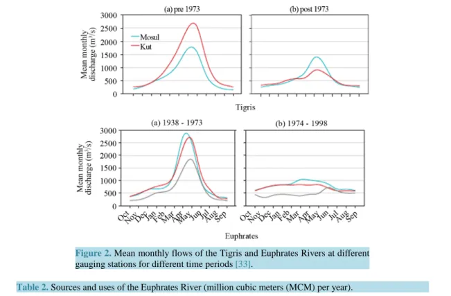
Generally, the total annual flow of the Tigris and Euphrates Rivers is of the order 80 × 109 m3. This figure greatly fluctuates from year to year (Figure 2). Furthermore, floods and drought are themselves of variable magnitude. Such variations are due to changing metrological conditions. The period extending from October to February is referred to as variable flood period where discharges in both rivers fluctuate depending on intensity and duration of rainfall at their basins. This period is usually followed by what is known as steady flood period extending from March to April.
Flow records show that minimum and maximum annual flow of the Tigris was 19 × 109 m3 in 1930 and 106 × 109 m3 in 1969, while for the Euphrates it was 9 × 10⁹ m3 in 1974 and 63 × 109 m3 in 1969, respectively. Table 2 and Table 3 summarize the source and uses of water in both rivers.
2.1. River Euphrates
River Euphrates rises in the mountains of southern Turkey. It runs about 1178 km in Turkey before interring the Syrian territory where it runs 604 km to reach the Iraqi border. Inside Iraq the length of river is 1160 km. the to-tal length of the river from Turkey to its confluence with the River Tigris south of Iraq is 2940 km, the toto-tal drainage area of the river catchments is 444,000 km2, Table 3, of which 28%, 17%, 40% and 15% lie in Turkey, Syria, Iraq and Saudi Arabia, respectively.
The Euphrates River rises east the Anatolian plateau between Wan lake and Black Sea in Turkey with two main tributaries (Figure 1):
a) Furat Su: This forms the northern tributary where it rises from the mountains situated northeast Ardhroom area with altitudes varying from 1800 to 3937 m above sea level. The total length of the tributary reaches 510 km. b) Murad Su: This forms the southern tributary where it rises north of Wan Lake at areas having altitude of 2350 to 3519 m above sea level with a total length of 600 km. Both tributaries join together 5 km north of Keban city. At Keban area the Keban dam was constructed with a total reservoir capacity of 30.5 × 10⁹ m3. The average annual flow of the Euphrates River in this area is 672 m3/s. The united river length in Turkey is 455 km. The shape of the catchments of the river in Turkey is a fan shaped which collects runoff at rainy periods in a short period of time causing sudden flood peak. The Euphrates River inters the Syrian border near Jorablus and flow to Albokamal at the Syrian-Iraqi border. The catchment’s area of the river before entering Iraq reaches 201,000 km2.
In Syria, three tributaries join the Euphrates:
a) Sabor River: total length of the river is 108 km, joining the Euphrates, from the right, 30 km south of Tri-poli city. The average discharge of the river is 3 m3/s.
b) Belaikh River: The length of this river is 105 km and joins the Euphrates from the left south of Raka city downstream Tabaka dam. The average discharge of the river is 36 m3/s and its catchment area is 14,400 km2.
Figure 2. Mean monthly flows of the Tigris and Euphrates Rivers at different
gauging stations for different time periods [33].
Table 2. Sources and uses of the Euphrates River (million cubic meters (MCM) per year).
Natural Flow Observed at Hit, Iraq
Removed in Turkey (pre-GAP) Removed in Syria (pre-Tabqa)
Naturalflow at Hit 29,800 820 2100 32,720 Pre-Kaban Dam (before 1974) Flow in Turkey Removed in Turkey Entering Syria Added in Syria Removed in Syria Entering Iraq Added in Iraq Iraqi Irrigation Iraqi return flow (est.)
To Shatt al-Arab 30,670 (820) 29,850 2050 (2100) 29,800 0 (17,000) 4000 16,800 Full Use Scenario
(circa 2040)
Flow in Turkey Removed in Turkey
Entering Syria Removed in Syria
Return flow and Tributaries(Turkey, Syria) Entering Iraq
Removed Iraq Return flow in Iraq Deficit to Shatt Al-Arab
30,670 (21,600) 9070 (11,995) 9484 6559 (17,000) 4000 (6441)
c) Khabor River: The length of this river is 446 km. Its catchment area is 36,900 km2 and lies in Turkey and Syria. Four small streams, i.e. Jaja, Jabjab, Etehad Aracha Alsaghir and Etehad Aradha Alkabeer, join this river. The khabor join the Euphrates south of Dier Al-Zor city and its mean daily discharge is 55.8 m3/s and could reach 500 m3/s during flood.
There are several dams constructed on the Euphrates River in Syria. One of the main dams is called “Tabaka”. The storage capacity of this dam is 11.6 × 10⁹ m3 (life storage 7.4 × 10⁹ m3). The maximum, minimum and mean discharge of the river Euphrates at Tabaka dam is 8500, 450 and 1300 m3/s, respectively. There are three more large dams; Tersanah, Teshreen and Muhardah with storage capacities of 225 × 106 m3, 210 × 106 m3 and 50 × 106 m3, respectively. In addition, 84 other small and medium size dams exist. The largest among these
Table 3. Sources and uses of the Tigris River (MCM per year).
Pre-GAP project Post GAP 2000 AD Natural flow
Flow from Turkey 18,500 18,500 18,500
Removed in Turkey 0 6700 Entering Iraq 18,500 11,800 Inflows to Mosul Greater Zab Lesser Zab Other Sub-Total 2000 12,100 7200 2200 43,000 2000 13,100 7200 2200 36,300 2000 13,100 7200 2200 43,000 Reservoir evaporation
Irrigation (to Fatha) Return Flow Adhaim Irrigation(to Baghdad) RETURN Flow Domestic Use Diyala River Irrigation Return Flow Sub-Total 0 (4200) 1100 800 (14,000) 3600 (1200) 5400 (5100) 1300 30,700 (4000) (4200) 1100 800 (14,000) 3600 (1900) 5400 (5100) 1600 19,600 800 5400 49,200 Reservoir evaporation Irrigation to Kut Return Flow 0 (8600) 2200 900 (8600) 2200 (to outfall drain)
Total Shatt Al-Arab 24,300 14,100 49,200
dams is known as Babalhadied with a storage capacity of 25 × 106 m3, while the storage capacity of the smallest dam is 30,000 m3.
The length of the river Euphrates in Iraq from the Syrian-Iraqi border at Hussaybah to its confluence with the Tigris River is 1160 km. once the river enters Iraq it trends toward the east and southeast to reach Anah city 100 km south of Hussaybah. The river then runs 220 km to reach Hit, with a river channel slope of 1:320 m. The channel is characterized by its shallow depth, large width and meanders. Islands are also noticed at the river channel. No tributaries join the Euphrates River inside Iraq apart from dry valleys originating from western desert. These valleys supply the river with flood water at rainy season from the desert. The minimum and max-imum recorded discharges at Hit are 55 on 5/9/1973 and 7460 m3/s on 13/5/1969.
The river runs 63 km south Hit to reach Ramadi city with a width reaching 250 m. At this area, Ramadi bar-rage was constructed to supply Warrar stream with water. This stream supplies Habariya Lake with excess water from the Euphrates during flood period. The length of this stream is 8.5 km which is designed to discharge up to 2800 m3/s. Water stored in Habaniya Lake can brought back to the river Euphrates when required through Dhi-ban stream which is located 42 km south of Ramadi city. In case of continuous flood flow, HaDhi-baniya lake cannot accommodate huge volumes of water and thus it was connected to Razazah lake and then to Abudibis marsh to release excess water.
South of Ramadi city the river flows 72 km to reach Falujah city. A complex of canals system was con-structed at this section of the river. A canal was dug from Tharthar large lake to supply the Euphrates River dur-ing drought periods; the canal joins the river 35 km north of Falujah city. The canal is designed to discharge water up to 1100 m3/s. It has a diversion which can supply excess water to the Tigris River if required. This di-version canal is 65 km long.
The Euphrates River runs south about 110 km to reach Hindiyah barrage. The river runs through fluvial depo-sits in this area. It should be mentioned however, that the Euphrates River channel inside Iraq upstream Hin-diyah is higher by 7 m than Tigris river channel. This is due to the fact that the Euphrates runs on the edge of the western plateau. This phenomenon was used since ancient times to dug irrigation canals from the Euphrates River running toward the Tigris River.
Hin-diyah barrage. South of Kifil, the river splits to eastern channel (Shamiyah) which takes 40% of the flow and western channel (Kufa) taking the remaindering 60% of the flow. On shamiyah river there are various regulating schemes established for a number of irrigation projects, i.e. Danaieb Alshanafiyah, Shalal Danaieb Alshanafiyah, Khuman and Naghshiyah regulating schemes. This channel joins the Euphrates River again 8 km upstream Sha-nafiyah city. The distance from Kifil to ShaSha-nafiyah is 99 km.
As far as the other channel, the Kufa, it runs to Abusskhair city and splits into two main channels. The small channel (on the right of the main channel) supplies four small irrigation streams, the main channel south of Ab-usskhair as Mushkhab River where Mushkhab barrage was established. The water flows to the south to reach Qadisiyah city and it again splits and joins again to form one channel. This channel joins Shamiyah channel again at Shanafiya city.
The river continues to run south for 105 km where it reaches Simawah city. After that the river Euphrates reaches Nasiriyah city. It should be mentioned however that this section of the river (Simawah-Nasiriyah section) has a number of irrigation projects and small intake stream. South of Nasiriyah city the river runs toward Al-shiyokh city and then enters Hammar Lake. Two channels leave Hammar Lake. The first joins the Tigris River at Qurna City while the other, the southern one, joins Shatt Al-Arab River at Karmat Ali.
2.2. River Tigris
The total drainage area of the Tigris River is 235,000 km2 distributed between Turkey (17%), Syria (2%), Iran (29%) and Iraq (52%) (Figure 1). The overall length of the river is 1718 km. It rises at the southeastern slope of Taurus Mountains at two sites, the western site is located near Diar city, 1500 m above sea level, with a dis-charge of 64 m3/s while the eastern site, known as Butman Su, near Sinan city a 270 m above sea level with a discharge of 96.3 m3/s. The river runs in a narrow valley bounded by Mardin Mountain range from the right and Raman Surat Hills from the left. Further down, another tributary (Karzan) joins the river near Bishwi village. The river runs south through rough mountainous area till it is joined by another tributary (Hazu) near ZEU vil-lage 240 km north of the Iraqi border. The discharge of this tributary is 59 m3/s. The river then runs in a plain area and joined by Butan Su River, with a discharge of 20.3 m3/s, to form the united Tigris River.
The river enters Iraq 4 km north Fieshkhabur near Zakha city. The Tigris is joined by its first tributary inside Iraq which is known as Khabur River. This tributary is 100 km long, it catchment area is 6268 km2 with an av-erage, maximum and minimum discharge of 68 m3/s, 1270 m3/s (11/4/1963) and 8 m3/s (6-14/9/1962), respec-tively. The Tigris River runs south for about 188 km in a hilly area to reach Mosul city. At Mosul the average, maximum and minimum discharge of the river is 668 m3/s, 7740 m3/s (2/5/1972) and 85 m3/s (October, 1935) respectively. The elevation of the channel bed is 225 m above sea level.
About 49 km south of Mosul toward Sharkat city, the Tigris joins its biggest tributary, the Greater Zab. The catchment of this tributary lies in Turkey, Iran and Iraq. Its total length is 437 km with a mean, maximum and minimum discharges of 450 m3/s, 9710 m3/s (2/4/1969) and 60 m3/s (22/11 and 4/12/1958) respectively. It sup-plies 28.7% of the Tigris water.
The Tigris River runs south toward Fatha gorge. About 30 km north of Fatha, the Lesser Zab tributary joins the river Tigris. The total catchment area of this tributary is 22,250 km2 of which 5975 km2 lie in Iran and the remainder in Iraq. The total length of the river is 456 km. The mean, maximum and minimum discharges of Lesser Zab are 227 m3/s, 3420 m3/s on 8/3/1954 and 6 m3/s on 14/5/1964, respectively. The river Tigris mean, maximum and minimum discharges at Fatha gorge are 1349 m3/s, 16,380 m3/s on 3/4/1969 and 200 m3/s in Oc-tober 1930, respectively.
Further south, the Tigris River enters the Mesopotamia plain 20 km north of Samara city and then Balad city. The Adhaim tributary joins the Tigris 15 km south Balad. The tributary drains an area of 13,000 km2 lying within Iraq. Its length is 330 km. The mean daily discharge is of the order of 25.5 m3/s; while the maximum rec-orded on 19/10/1960 reached 3520 m3/s. this tributary runs almost dry during June to November each year. The banks of the river Tigris south its confluence with Adhaim tributary are below the maximum flood peak level by 3 m from the left and 1.8 m from the right.
Further to the south, the river reaches Baghdad. At Baghdad the mean, maximum and minimum discharges are 1140 m3/s, 7640 m3/s on 12/2/1941 and 163 m3/s in October, 1955 respectively. The slope of the channel is very low i.e. 6.9 cm/km. About 31 km south of Baghdad, the last main tributary “Diyala” joins the Tigris. Diya-la’s drainage basin is 31,896 km2 of which 20% lies in Iran and the rest in Iraq. The mean daily discharge is 182 m3/s while the maximum and minimum discharges are 3340 m3/s on 25/3/1954 and 12 m3/s on 7/9/1960,
respec-tively.
Downstream the confluence of the Tigris-Diyala River, the Tigris channel is characterized by its large number of meanders. In addition, the river discharge steadily decreases downstream due to losses. These losses include evaporation, infiltration and mainly water withdrawal through irrigation canals. Important irrigation canals in-cludes: Gharaf, south Kut city, Great Majar, South Emarah city, Mushrah and Kahlaa, South Emarah city, and Majariah canal, South Qalaat Salih. In addition, this stretch of the river is well known by the abundant occur-rence of big marshes on both sides of the Tigris River. There are many small streams running from Iran toward Iraq where they discharge their water in the marshes e.g. Karkha stream discharging its water in Hiwazah marsh. The Tigris channel reaches its minimum width at Kasarah area south of Emarah city. At Qalaat Salih the mean daily discharge of the river is 80 m3/s. Downstream this city the river joins the Euphrates River at Qurnah city forming Shatt Al-Arab River.
2.3. Shatt Al-Arab River
Shatt Al-Arab River is formed after the confluence of Tigris and Euphrates Rivers at Qurnah in Iraq (Figure 3). Its total length is 192 km and its drainage area is 80,800 km2. Its width is about 300 m near Qurnah and increas-es downstream to 700 m near Basra city and to about 850 m near its mouth at the gulf area. Karun and Karkha Rivers usually contributes 24. 5 and 5.8 billion cubic meters (BCM) annually respectively (Figure 3). This forms about 41% of the water of Shatt Al-Arab. Its annual discharge at Fao city reaches 35.2 × 10⁹ m3. Shatt Al- Arab River is characterized by its high sediments which resulted in the formation of large number of islands during its course.
3. Causes of the Conflict
Number of factors escalated the conflict over water issues in the Middle East.
3.1. Population Growth Rate and Food Security
Population growth rate is among the highest in Syria and Iraq (Table 4). The total population of the Middle East was about 20 million in 1750 this number tripled in 1950 and quadrupled to about 286 million in 1996 and ex-pected to double within 30 years [34]. Accordingly, water allocation per capita decreases with the increase of population [35]. In addition, the region imports 50% of its food requirements [12] and this percentage is in-creasing with time [34].
The largest consumer of water across the region is agriculture where it accounts for 66% of demand [2][11]
and therefore the water shortage problem cannot be objectively analyzed nor adequately addressed without a thorough consideration of agriculture [12]. If we consider 10% transfer of water away from agriculture would produce a 40% increase in domestic water supply for Jordan [12]. However, this is not the case in many Middle Eastern countries which have unrealistic aspirations of food self-sufficiency and in it would require a most
Table 4. Population characteristics within Tigris-Euphrates Basins (modified from [34]).
Country Population (million) Rate of growth (%) Projected population 2025 (million) Percent urban
Turkey 63.9 1.6 78.3 63
Syria 15.5 3.7 31.7 51
Iraq 21.4 3.7 52.6 70
fundamental change in national outlook [15]. Sadik and Barghouti [12] emphasized that the extent of the prob-lem is so severe that “the future challenges in meeting the growing demands for water are beyond the capabili-ties of individual countries”. Mitigating supply shortfalls could be achieved by re-allocation of current agricul-tural supplies [1]. Future predictions suggest more shortages and depletion of groundwater resources [19][20] [33].
Iraq and Syria were grain exporters and now they are importers. The capability of these countries to produce grains is less than that of Turkey [36]. The goal of Turkey to turn its GAP area into a breadbasket will threaten the irrigation based agricultural potential of the lower riparian [36]. Syria tries to achieve self-sufficiency long time ago and continue to be so. It doubled its irrigated land and tried to use drip irrigation so that further in-crease can be achieved. Due to water scarcity, wheat yield dein-creased by 50% and much of the livestock had died. This situation caused many people to join insurgents so that they can survive [37]. As far as Iraq is concerned, the plan was to be grain exporter by 2017 [38][39]. Iraq is importing all its food now [40][41]. The country was one of the few regional cereal exporting countries in the region in the past. Now it is evident from food shops in Baghdad (for example) that everything is imported apart from dates, which implies that the agricultural outcome is disastrous [40][41]. It should be mentioned however, that the goals of the governments in Syria and Iraq con-sider this plan of food self-sufficiency is of minor importance and priority is given to national security problems especially the threat of ISIS.
3.2. Energy Security
Turkey uses hydropower relatively more than Syria and followed by Iraq [42]. Due to the fact that Turkey is not an oil producing country, it does not like to rely on importing oil as an energy source. Turkey wishes to reduce its dependency on imports of expensive oil by producing at least 40% of its required energy from national hy-droelectric resources [43]. GAP project is one of these sources where it is anticipated that it will reduce import-ing 28 million tons of oil [44].
On the other hand, Iraq is oil exporter since early 20th century and Syria became oil exporter in 2001 while Turkey imports about 63% of its fuel. Syria relies on hydropower to generate electricity despite the fact that they have oil reserves and this gives Turkey the chance to threaten Syria by decreasing the discharge of the Euphrates using the GAP project. Despite the continuous declarations from the Turkish Government that GAP is purely a development project, it seems that there are number of internal and external goals involved as well [45]-[49].
3.3. Economic Development
Syria and Iraq experienced rapid economic development and rising of the standard of living [35] due to the fast increase of oil prices. This raised the demand for water for domestic and industrial uses. In view of these devel-opments the water claims of the three counties (Syria, Iraq and Turkey) add up to 149% of the total water avail-able [42]. To achieve its development goals, Turkey is planning to use water. This was very clear when presi-dent of Turkey in 1992 declared at Ataturk dam opening ceremony that “Neither Syria nor Iraq can lay claim to Turkey’s rivers any more than Ankara could claim their oil… The water resources are Turkey’s, the oil re-sources are theirs. We don’t say we share their oil rere-sources, and they can’t say they share our water rere-sources”
[50]. In addition, Turkey is trying to use water to improve its relationships with other countries by trading water. The proposed Peace Pipeline and Manavgat River project focus to trade water with Mediterranean and Middle East neighbors [51].
Furthermore, the ongoing development in the Middle East led more than 50% of the population to move from rural to urban areas. This aggravates the water shortages problem where in urban areas the water consumption is 10 to 12 times its rate per capita as village dwellers [34].
3.4. Technological Development
Technological developments had increased water losses where large dams were build which increased evapora-tion rates and huge quantities of water is lost in irrigaevapora-tion projects due to inefficient irrigaevapora-tion methods. Riparian countries within the Tigris-Euphrates basins do not use new technologies to save water in their agricultural prac-tices. Syria tried to adopt new technologies in irrigation practices but it did not work because farmers could not adapt quickly to the new technologies [52].
3.5. Political Fragmentation
After World War I the area had been divided into number of countries. Before that, the Ottoman Empire domi-nated much of the Middle East for 500 years. During that period, conflict among different people dampened. After that, ethnic consciousness increased which lead to growing disparities and rivalries in the region and all the people became more competitive and nationalistic. During the twentieth century cold war had a restraining effect on the likelihood of major conflicts, and this does not exist now. Surface waters and groundwater re-sources overuse and pollution became a source of friction and tension. Good examples are the 1967 war between Israel and Arab states where water was one of the underlying causes as well as the Israeli occupation of Lebanon in 1982 where they occupied Litani River and diverted its water. In addition, 40% of Israel water is extracted from aquifers beneath the West Bank and Gaza [34]. Future prediction models suggests that groundwater in depleting [19] [20][33] as well as surface water [16]-[18][53][54]. Restoring the marshes [53][54] and the growing demand for water in Turkey and Syria will lead to dry the Tigris and Euphrates Rivers in 2040 [55].
3.6. International Water Laws
Existing international laws might be suitable for non-arid regions like Europe but they are inadequate for arid regions like the Middle East. Legal principle exists in these laws, but there is no legally binding international obligations for countries to share their water [56]. Accordingly, agreements depend upon the goodwill of the ri-parian in any particular drainage basin. In this case a number of factors can raise the conflict such as relative po-sition of the country within the drainage basin, degree of national interest in the problem and the power (both internal and external) available for the country to pursue its politics [57].
3.7. Water Availability
Turkey argues that the allocation per capita in Iraq and Syria in suitable for the requirements of people in these countries (Table 5) [58].
3.8. Water Management
Water scarcity problem have been exacerbated due to poor water management [35] in the Tigris and Euphrates basin. Huge quantities of water are wasted through inefficient irrigation systems such as flood irrigation, unlined and/or uncovered canals as well as evaporation from reservoirs (Figure 4 and Figure 5). Extensive use of chemical fertilizers and pesticide in farming had affected the water quality of rivers and groundwater (Figure 4 and Figure 5). Dumping of industrial and domestic waste in the rivers increased the pollution of these rivers in particular at the downstream riparian. This causes dissatisfaction and frustration and crates irritation that might lead to conflict.
Table 5. Water allocation per capita per year in Turkey, Syria and Iraq (a[59]; b[60]).
Country 1990 2000 2010 2020
Turkey 3223 2703 2326 2002a, 980b
Syria 1636 117 880 760a, 780b
Iraq 2352 1848 1435 1062a, 950b
In this context, these figures do not include certain problems like restoring the Iraqi marshes. Furthermore, when GAP project is completed these figures will be decreased.
Figure 4. Salinity variation along Euphrates River since 1996 [33].
Figure 5. Salinity variation along Tigris River before 1983 and after 1995 [33].
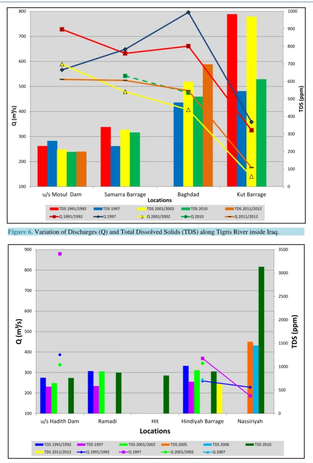
ESCWA [33] collected the information about the total dissolved solids (TDS) of the Euphrates River (Figure 4). At Ataturk dam the TDS is about 300 ppm. The salinity in Euphrates River at the Syrian-Iraqi borders is 600 mg/l which is already higher that the recommended level for irrigation (Figure 4) and it increases to more than 1200 mg/l (minimum) downstream at Samawah (World Bank, 2006; IMMPW, 2011).
Within Iraq, the source of most of the back irrigation water is from irrigation projects that are located in the central and southern parts of the country (1.5 million ha). Back irrigation water from these projects is directed to the main outfall drain which drains to the gulf in order to reduce the soil salinity [63]. Despite the presence of these drainage measures, the salinity increases downstream along the courses of the two rivers in conjunction with decreases in their discharges (Figure 6 and Figure 7). This situation overstressed the agricultural sector in the southern Iraq. Tracking the changes of Tigris River’s salinity shows that significant increase starts from Baghdad downward. This is due to the effect of the feedback from Tharthar depression toward Tigris River
Figure 6. Variation of Discharges (Q) and Total Dissolved Solids (TDS) along Tigris River inside Iraq.
Figure 7. Variation of Discharges (Q) and Total Dissolved Solids (TDS) along Euphrates River inside Iraq. 0 100 200 300 400 500 600 700 800 900 1000 100 200 300 400 500 600 700 800
u/s Mosul Dam Samarra Barrage Baghdad Kut Barrage
TDS (p pm ) Q (m ³/s ) Locations TDS 1991/1992 TDS 1997 TDS 2001/2002 TDS 2010 TDS 2011/2012 Q 1991/1992 Q 1997 Q 2001/2002 Q 2010 Q 2011/2012 0 500 1000 1500 2000 2500 3000 3500 100 200 300 400 500 600 700 800 900
u/s Hadith Dam Ramadi Hit Hindiyah Barrage Nassiriyah
TDS
(ppm
)
Q (m
³/s)
Locations
TDS 1991/1992 TDS 1997 TDS 2001/2002 TDS 2005 TDS 2006 TDS 2010 TDS 2011/2012 Q 1991/1992 Q 1997 Q 2001/2002 Q 2007saline (Figure 8), and then it is redirected for use in the river system with the salt washed from the depression. Recent estimates indicate that 4% of irrigated areas are severely saline, 50% are of medium salinity and 20% are slightly saline [65]. This forced the government to undertake a land rehabilitation program and a total of 700,000 ha were reclaimed. Later the situation deteriorated where recent estimates indicate that 4% of irrigated areas are severely saline, 50% are of medium salinity and 20% are slightly saline [66].
3.9. Public Awareness
Conservation is a cost-effective means of securing future water supplies since security of freshwater is emerging as a worldwide issue due to growing population and limited supplies, coupled with diminishing availability due to inadequate management, deforestation and increasing pollution. To achieve secure and sustainable water for future generations, the efficiency of current water supply and usage needs to be improved. Such program should be an interactive movement in which different parties are engaged, each with their own roles, responsibilities and ways, to make their voices heard and create social pressure [67].
Governments in the Tigris-Euphrates basins should adapt a multi-step framework for preparing an overall strategy and designing a public water awareness program that includes promotional activities, implementing the activities and monitoring and evaluating their effectiveness. As a first step is to educate politicians and policy makers; water planners and managers; and social marketers and educators about the importance of water con-servation in the potable water supply sector and how it may be approached, so that they can take part in national water awareness program and promoting it to society as a whole. Professionals in the water sector and education officials should setup special curricula in schools by developing and finding ways to introduce the subject. The media can play an important role in raising awareness about the importance of water issues where the lack of public perception of the importance of proper water management and the ignorance of the impact of political and economic decisions of the long term guarantee of water resources are one of the biggest problems in the Middle East. Since agriculture is the highest water consumer in the region, farmers are to be educated on the use of new irrigation techniques that are suitable for arid regions.
It is believed that the countries concerned in the Tigris Euphrates Basins should adopt the outlines of the pro-gram set by [68]. These are:
What are the rules and regulations for water and wastewater permits? How is the water produced and distributed?
How is the wastewater collected and treated?
How does your utility provide maintenance and repair services? What kind of customer service does your utility provide? What conservation measures are in place?
Figure 8. Total Dissolved Solids concentration at Samarra Barrage (the supply-
4. International Agreements
Tigris and Euphrates basins are shared different countries (Turkey, Syria, Iraq, Iran and Saudi Arabia). Iraq (in particular) and Syria are the lower countries in the basin and for this reason they always like to ensure the quan-tity of water required to satisfy their domestic, industrial and agricultural requirements. They also consider these basins as international “watercourses” which should be treated as an integrated entity by all the riparian users. Turkey regards the Euphrates River as “trans-boundary River” which is under its exclusive sovereignty until it flows across the border and when it joins the Tigris River to form Shatt Al-Arab River then it becomes an inter-national river.
Turkey was the only country within the Euphrates basin (and one of the only three countries) that voted against the International Law Commission of the United Nation on the law of Non-navigational Uses of Interna-tional Watercourses in 1997. Turkey also considers that the convention does not apply to them and for this rea-son it is not legally binding [69]. In addition, Turkey considers that Tigris and Euphrates Rivers are in one basin due to the fact that they join together to form Shatt Al-Arab River while Syria and Iraq consider them as sepa-rate basins. Turkey also likes to negotiate all the water resources in Syria and Iraq while Syria opposes to dis-cuss the water resources of other rivers in Syria (Orontes River and upper headwaters of the Jordan including the Yamouk River). As far as Iraq is concerned, they also refuse to discuss the water coming from the Iranian val-leys to Iraq. Turkey seek absolute territorial sovereignty on the Tigris and Euphrates water while Syria maintains a blend of the Harmon Doctrine called limited territorial sovereignty, and absolute territorial integrity, due mainly to the 24 percent of Euphrates river length in the country and 17% of drainage area [70]. Syria also laid claim to the Tigris, even though only 44 km run along their common border with Turkey.
There have been number of attempts to find a common ground on water issues between the main three ripa-rian countries since 1920 but no agreement signed yet. The first treaty concerning the Tigris and Euphrates Riv-ers was signed between France as the mandatory power for Syria and Great Britain the mandatory power for Iraq in 1920. They agreed to establish a committee to examine and coordinate the use of the Euphrates and Ti-gris Rivers [33][71]. One year later, another agreement was signed between Turkey and France (as mandatory for Syria) where it states in article 12 that Aleppo city can use the water of the Euphrates River. In 1923, the agreement known as Lausanne agreement was signed between Turkey and allied powers. In this agreement it was agreed that issues related to trans-boundary water should be dealt with separately and with mutual respect. It also includes a provision that Turkey must consult Iraq before undertaking any hydraulic works (article 109)
[33][71]. Treaty of Friendship and Good Neighborly Relations was signed between Turkey and Allied powers in 1926. In this treaty they agreed to cooperate together to use the Euphrates basin. Then in 1930, the Tur-ko-French Protocol (on Commission of Delimitation) was signed between Turkey and France (Syria) states that the border between the two countries is to follow the thalweg principle, establishing the border in the middle of the Tigris, regardless of shifts in the river’s course [33].
Iraq and Syria gained their independence in 1932 and 1946 respectively. Turkey renewed its promise to con-sult Iraq before beginning any development projects on the Tigris and Euphrates in the 1946 Ankara Treaty of Friendship and Good Neighborliness [72]. It is considered as the first legal instrument of cooperation. They agreed that Turkey shall install and operate permanent flow measurement facilities and inform Iraq periodically about the recorded data (article 3) and water infrastructure projects [33] [71]. No major river development projects from the 1920’s till early 1950’s and the first few hydrological projects began in the 1950’s in Iraq where Samarra and Euphrates Dams were built in 1954 and 1956 [71][73]. The three riparian countries had their first set of talks about the Tigris Euphrates-Basin in 1965. Proposed dams to be constructed were discussed, specifically the Tabqa Dam in Syria and Keban Dam in Turkey. The talks came to a standstill in 1974 after 22 rounds [74] where Turkey claimed that it will make a tripartite agreement only if there was an “inclusive agree-ment on the distribution of the waters of all the rivers common to it and Syria” [75]. Dams proposed in the 1960’s became operational in the 1970s. Keban Dam became operational in 1973, and Syria’s Euphrates High Dam at Tabqa became operational in 1974. The situation became very tense between |Iraq and Syria, the latter promised to supply Iraq with 200 million cubic meters (MCM) from Tabaqa. In 1975, Syria was impounding Assad Lake which deprived Iraq of some of its promised water share. Syria claimed that it did not receive half of its normal flow from Turkey [76]. Iraq asked the Arab League and later Saudi Arabia and Egypt to mediate but all efforts failed. Tension was so high that both countries amassed troops along their border in June, 1975. Saudi Arabia proposed that Iraq and Syria should share water on a basis proportional to how much water Syria rece-ives from Turkey. This eased the situation but no agreement was signed. In 1977, Turkey expanded the Lower
Euphrates Project was expanded and became Güneydogu Anadolu Projesi, the Southeastern Anatolia Develop-ment Project (GAP) [73].
In 1980, a protocol for technical and economic cooperation was signed between Iraq and Turkey. Syria signed the protocol in 1983. According to the protocol, a joint technical committee (JTC) was established to study the issue of regional waters-particularly the Euphrates and Tigris Rivers [33] [76]. In the 1980s, Syria conducted subversive actions against Turkey where they allowed Kurdish and Armenian rebels attacking GAP projects to headquarter in Syria [77]. At that time Iraq allowed Turkey to attack the Kurdistan Worker’s Party (PKK) on Iraqi soil. Later, in 1987 Syria and Turkey signed Protocol on Economic Cooperation. In that protocol, Article 7 of the protocol states that Syria and Turkey shall work together with Iraq to allocate Euphrates and Tigris water within the shortest possible timeframe. Article 9 asserts the intention of the two states to construct and jointly operate irrigation and hydropower projects on the two rivers [33]. According to this protocol, Turkey should provide Syria with 500 cubic meters per second of the Euphrates [77]. Iraq was frustrated that it was not in-cluded in the 1987 protocol and for this reason it did not allow Turkey to attack the PKK in Iraq and in 1988, Iraq suppressed its Kurdish uprising in February 1988, 60,000 Kurds fled to Turkey, further deteriorating their relationship [72].
From January 13 to February 13, 1990 Turkey practically did not release water to Syria so that it can fill the Ataturk Dam. After this action, Iraq and Syria officially agreed that 58% of the Euphrates water that Syria rece-ives would be provided to Iraq [73]. Syria continued to allow the Kurdish rebel group (the PKK) to attack sou-theastern Turkey from Syrian soil. Turkey had reached their breaking point with Syria’s lack of cooperation in October 1998 where it wanted Syria to stop supporting terrorists immediately, which was understood as a threat of military intervention. Syria responded and then Turkey and Syria signed the Adana Accord and relationship between these two states improved from the late 1990’s through the early 2000’s. Both countries signed another agreement in 2001 between GAP’s Regional Development Administration (GAP RDA) and General organiza-tion for Land Development (GOLD) [76].
In 2002, Iraq and Syria signed agreement on the Creation of a Pumping Station in Syria on the Tigris. It go-verns the establishment of a Syrian pumping station on the Tigris River. It also specifies project area and volume of water extracted [33]. During the period 2007 to 2009, the entire region experienced a drought which affected the amount of water that Turkey releases to Syria and Iraq. Turkey and Syria signed a new agreement in 2009 referred to as “Strategic Cooperation Council Agreement”. They agreed that water is a focus point for coopera-tion between the two countries with emphasis on improvements to water quality, the construccoopera-tion of water pumping stations (on the Syrian stretch of the Tigris) and joint dams, as well as the development of joint water policies [33]. In addition, Turkey agreed to assist Iraq through this drought with additional water, but this did not lead to any agreements on long-term water sharing [78]. In view of the present internal situation in Syria and Iraq with the occupation of ISIS parts of these countries, the water issue is not considered as a priority now. Now, the situation is very bad both in Iraq and Syria.
5. Possible International Efforts to Solve the Conflict
The past efforts in solving the conflict on water rights in the Tigris-Euphrates basins were based on bilateral talks and/or agreements. Such talks or agreements are insufficient to begin discussions for a regional solution. In view of this, a third party is required to intervene to bring Turkey, Syria and Iraq together because they failed to initiate successful triplicate negotiations. Akanda et al. (2007) believe that water issues are usually eclipsed by more politically charged concerns; it is of prime importance to use additional incentives to bring all the parties together. To entice Turkey to negotiate, two issues can be used. The first is its struggle to join the European Un-ion which requires Turkey to improve its human right record. This can be done by involving the Kurds in a co-operative water utilization effort [42]. The second is external funding to finish the GAP project. Possible fund-ing agencies are EU and World Bank. These agencies will require an agreement with downstream riparian coun-ties before releasing any fund [42]. Development assistance, by financial and technical support and increased water efficiency can be the enticement factors for both Iraq and Syria. This will help these countries in develop-ing their agricultural plans includdevelop-ing more innovative advanced projects [42]. An external mediator can high-light and frame the issues in such a way that each country believes that it is gaining by joining the discussion and will lose something by avoiding the discussions.
-World Bank: The World Bank has good history in mediating water disputes. In addition, it technical exper-tise to ameliorate the inefficient, water wasting practices of the countries involved. The riparian countries will also have the access to the Bank funding and the Bank itself has financial incentives to reach a resolution so that it can provide loans to these countries.
-USA and EU: Both USA and EU have the political, technical and economic powers to be used as mediators. Turkey is connected with different treaties with USA and is willing to be part of EU as well as defense agree-ments (e.g. NATO) can force Turkey to join water issues negotiations. The same applies for Iraq and Syria. All riparian countries would like to have the expertise, technical and financial support of these international power-ful forces.
-United Nation: UN has very good record for mediation in different occasions all over the world. United Na-tion or its agencies (e.g. UNEP or UNDP) possess the informaNa-tion about different aspects in the riparian coun-tries. This includes the needs and requirements. Furthermore, the UN can use the Security Council if required to enforce agreements.
-Saudi Arabia: This country is considered legitimate by the riparian countries, plus it has the financial re-sources to contribute to a basin fund that would finance on going and future water related plans. Saudi Arabia also has the experience in mediation where it resolve the conflict between Iraq and Syria during 1974-75 wher both countries were on the verge of war and Saudi Arabia brought both parties on the table of negotiation and achieved a final resolution.
-Egypt: Egypt has good experience in basin agreement gained from the Nile Basin initiative. It was involved in resolving the crises between Turkey and Syria in 1998 when Turkey accused Syria supporting the PKK and harboring its leader. Egypt can use the lessons gained from the Nile basin conflict and apply them to resolve the Tigris-Euphrates basins conflict.
6. Problems Facing the Lowest Riparian Country
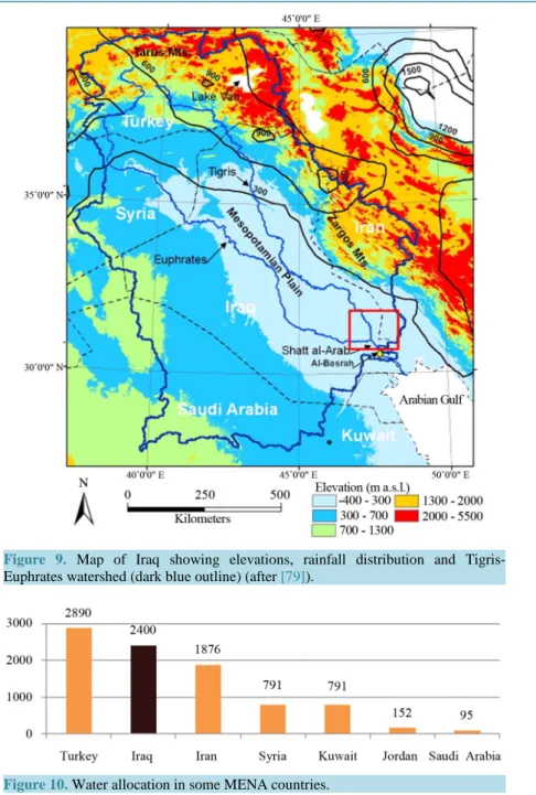
Due to its geographic location, Iraq is the lowest riparian country in the Tigris-Euphrates basins (Figure 9). For this reason, Iraq is the mostly affected country relative to Syria and Turkey. Iraq is part of the Middle East bor-dered by Turkey from the north, Iran from the east, Syria, Jordan and Saudi Arabia from the west and Kuwait and Saudi Arabia from the south (Figure 9). It covers an area of 433,970 square kilometers populated by about 32 million inhabitants.
Iraq is facing serious water shortage problem as part of regionally problem [26] [80]-[83]. Wilson [84] re-ported that 100,000 Iraqis have fled their native communities since 2005 due to water shortages according to UNESCO study. The same study found that 70 per cent of the Karez in Iraq that were providing water in 2005 were dried up and abandoned by 2009 which put 36,000 people at risk of being displaced. In addition, water le-vels in the Tigris and Euphrates have fallen by more than two-thirds and warned that these vital lifelines could dry up completely by 2040 [84]. Decline in water supplies caused the worst cereal harvest in a decade in 2009 in Iraq, indicating comes a potential future food security problem [84].
The problem is expected to be more chronic and severe in future. MacQuarrie [70] estimated that the deficit in water will be over 20 billion cubic meters. Despite the differences in numbers given by various sources, there is an overall agreement that there is a gap between supply and demand [32][55][85][86]. The overall estimate of water required is 75 to 81 BCM [86]. Irrigation consumptive use reached 39 BCM in 1991 and in 2003/4 it was 22 BCM equivalent to 44 BCM of water derived, assuming 50% irrigation efficiency. Real efficiency might be 25% - 35% [86]. The agricultural land cropped is about 1.9 million ha in recent years out of 3.5 million ha. If all this area is cropped then the water requirement is 50 BCM assuming good irrigation efficiency.
The demand from the sanitation sector is about 5 BCM and due to the fact the infrastructure system is out of service, losses have increased. It should be mentioned however, that the demand of the industrial sector de-creased. Hydropower use including the evaporation from reservoirs reaches 10 BCM/annum. Restoring the marshes requires 16 BCM and demand for in-stream flow reaches 3 BCM/annum. UN and SIWI [55][87] esti-mates indicate that available water in Iraq reaches 75 BCM (2400 m3 per person per year which is more than neighboring countries with the exception of Turkey (Figure 10).
The overall water demand excluding restoring the marshes is about 73 BCM and the available water is about 59 - 75 BCM. If the situation remain as it is the Iraqi water supplies will drop to 43 BCM by 2015 and to 17.61 in 2025 [55] and the demand is 66.85 BCM [88] or 77 BCM [89].
Figure 9. Map of Iraq showing elevations, rainfall distribution and Tigris-
Euphrates watershed (dark blue outline) (after [79]).
Figure 10. Water allocation in some MENA countries.
It should be noted however that the quality of water deteriorates from north to south along both the Tigris and Euphrates Rivers where it approaches a salinity of about 2000 mg/l in Basra [61]. According to the World Bank
[86], the Iraqi water deficit in 2030 will reach 25.55 BCM (37%) where the expected supply is 44 BCM only. Recent reports state that the Tigris and Euphrates rivers will be completely dry by 2040 [55].
The cause of this problem is attributed to external factors (Global climatic change and abusive water policies by riparian countries) and internal factor (poor management of water resources) [90][91].
6.1. External Problems
1) Global Climate Change: Middle East and North Africa (MENA) region is among the most vulnerable in the world to the potential impacts of climate change [90]. The most significant changes in MENA region which al-ready suffers from aridity (Figure 11), recurrent drought and water scarcity are the increased average tempera-tures, less precipitation and more erratic, and sea level rise (SLR).
Figure 11. Aridity zones of the world [96].
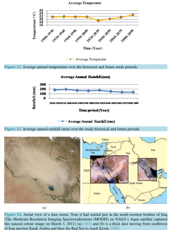
Records of temperature highs in 2010 show that five countries from MENA region including Kuwait (52.6˚C), Iraq (52.0˚C), Saudi Arabia (52.0˚C), Qatar (50.4˚C), and Sudan (49.7˚C) were among the top 19 countries ef-fected [92]. The drought will affect the agricultural life and water supply at MENA region (Medany, 2008). This is due to the fact, that most of the agricultural areas of MENA region are rain-fed [93]. For example about one-third of Iraq’s cereal production (wheat and barley) is produced under rain-fed conditions at northern part of Iraq [94]. CGCM3.1 (T47) model with A2 scenario was chosen in order to simulate the average monthly temperature and rainfall on Iraq for the historical period 1900-2009, and for mean future projected temperature and rainfall till the period 2099 [95]. The results of simulation and prediction are shown in Figure 12 and Figure 13.
A comparison between the values of annual temperatures (Figure 12) shows that the increase of annual tem-perature was limited during the historical period 1900-2009, but the increase is more noticeable during the pe-riod 2020-2099. Rainfall trend (Figure 13) expects that rainfall will increase till 2039 followed by decrease till 2099. The future predicted part in Figure 13 shows that an increase and decrease of the total summation of the rainfall (average annual) through the four periods of 2020-2039 (175.41 mm), 2040-2059 (150.96 mm), 2060- 2079 (134.59 mm), and 2080-2099 (135.31 mm) in Iraq. Chenoweth et al. [11] stated that rainfall will be de-creasing to 158 and 155 mm per year in 2040-2069 and 2070-2099 respectively. Recent work by Al-Ansari et al.
[97]-[99] using daily rainfall data in scenarios A2 and B2 of the same model indicated that rainfall will be de-creasing till 2099. It should be mentioned however, that the general trend is dede-creasing but annual rainfall is ex-pected to highly fluctuate round the general trend.
Dust storms may lead to aerosol pollution which change cloud properties and then reduce precipitation in the polluted region. In the desert land, the limited precipitation will help to produce more dry soil which leads to produce more dust in the air [100]. Al-Bayati [101] indicated that there are eleven factors that affect the fre-quency of dust storms phenomenon in Iraq, the most factor affective was relative humidity while the evaporation and clouds quantity were the lowest. For the past few years, Iraq was experiencing plenty of dust storms. Figure 14(a) is an aerial view (taken March 3, 2011) of a dust storm started just in the north-western borders of Iraq
[102] and Figure 14(b) was taken in 2005 for thick dust moving from southwest of Iraq passing Saudi Arabia and the Red Sea to reach Egypt [103].
The 20th century global warming has expanded the size of seas and oceans, as well as loss of land ice [104]. Through the period of 1961-2003, it was observed that the global sea level rise was about 1.8 mm per year while during the period 1993-2003 it reached up to 3.1 mm per year (IPCC, 2007b). AFED [90] and Dasgupta et al.
[105] reported that the Arabian Gulf will be highly vulnerable at its northern tip north of Kuwait and south of Iraq (Shat Al-Arab) to SLR. Despite the limited coastline Iraq has on the Gulf region, the vulnerable low land areas extend as far inland as near Baghdad (Figure 15).
At the end of the century the mean temperatures in MENA region is projected to increase 3˚C to 5˚C while the precipitation will decrease about 20% [106]. Water run-off will be reduced by 20% to 30% in most of MENA by 2050 [107] and water supply might be reduced by 10% or greater by 2050 [108]. However, Arnell
[109] indicated that the magnitude of change is highly uncertain.
2) Water Policies of Riparian Countries: All landowners whose property adjoins a body of water or river have the right to make reasonable use of it and the right to access for swimming, boating and fishing as it flows
16 18 20 22 24 26 T e m p er a tu re ( °C) Time (Year) Average Temperatur Average Temperatur
Figure 12. Average annual temperature over the historical and future study periods.
Figure 13. Average annual rainfall (mm) over the study historical and future periods.
(a) (b)
Figure 14. Aerial view of a dust storm. Note it had started just in the north-western borders of Iraq (The Moderate Resolution Imaging Spectroradiometer (MODIS) on NASA’s Aqua satellite captured this natural colour image on March 3, 2011) (a) [102] and (b) is a thick dust moving from southwest of Iraq passing Saudi Arabia and then the Red Sea to reach Egypt, [103].
through or over their property. If water is lacking to satisfy all landowners, rations are generally fixed in propor-tion to frontage on the water source [111].
Many studies tried to draw figures for the water requirement for Turkey, Syria and Iraq (the riparian countries) from Euphrates and Tigris Rivers. Estimates for required water from Euphrates River to irrigate all the culti-vated lands along it are 15.7, 11 and 13 km3 for Turkey, Syria and Iraq respectively. It should be mentioned however that, other authors had cited different figures for the water requirement for Turkey, Syria (7.95 km3) and Iraq (19 km3) [112].
During the 1970s Syria and Turkey started to construct dams on the Euphrates and Tigris Rivers which caused a major decrease in the flow of the rivers [3][32] as well as deterioration of the quality of their water [113].
Figure 15. Effect of sea level rise on Iraq and Kuwait [110].
In 1977, the Turkish government set a huge project referred to as Southeastern Anatolia Project (GAP) [114]. The component of the project includes 22 dams and 19 hydraulic power plants (Table 6) which are supposed to irrigate 17,000 km2 of land [115]. The project is supposed to develop the southeastern provinces which cover 9.7% of the total area of Turkey which forms 20% of the agricultural land of the country. The overall volume of water to be captured is about100 km3 (while the required water to irrigate the supposed area is about 29 km3) which is three times more than the overall capacity of Iraq and Syrian reservoirs. Despite the continuous claims of the Turkish Government that GAP is purely development project, it seems that there are number of internal and ex-ternal goals involved [45]-[47][49]. When GAP project is completed, then 80% of the Euphrates water will be controlled by Turkey [116][117].
When Ilisu dam on Tigris River is operating then, Iraq will receive only 9.7 km3[118]. This implies that 47% of the river flow will be depleted. This in turn means that 696,000 ha of agricultural land will be abandoned due to water scarcity [32]. Recent reports state that Tigris and Euphrates rivers will be completely dry by 2040 [55].
Syria built three main dams (Table 7) along Euphrates River with a total storage capacity of 16.1 km3 for ir-rigation and electricity generation.
Syria used to receive 21 km3/year of the Euphrates water prior 1990 which dropped to 12 km3 in 2000 onward (40% reduction). As far as Iraq is concerned, the volume of water received dropped from 29 km3 before 1990
[119] to 4.4 km3 (85% reduction) now. Due to this reduction in water shares, the agricultural used land in both countries had been reduced from 650,000 ha to 240,000 ha. In addition, the quality of water deteriorated due to back water irrigation directed toward the main channel in its upstream reaches [32].
Syria is planning to double its irrigated area (740,000 ha). This will increase its water withdrawal from 5 km3 to 9 km3[86] and will cause:
• Diminishing of water for agriculture.
• Land degradation due to expected high salinity.
• More drying of the marshes causing more ecological damage.
• Further deterioration of the already bad water quality of the Euphrates (TDS is 1800 mg/L now). • Less hydropower generation.
• Rising the risk of regional conflict.
• Demographical implications where farmers and fishermen will leave their homes. • Lower groundwater levels.
In addition to the above, Iran had recently diverted all perennial valleys running toward Iraq inside Iran. Fur-thermore, water of Karkha and Karun Rivers had been almost completely diverted inside the Iranian borders and no water is contributing to Shatt Al-Arab River from these tributaries (Figure 3).
Shatt Al-Arab River is formed after the confluence of Tigris and Euphrates Rivers at Qurnah in Iraq. Its total length is 192 km and its width is about 300 m near Qurnah and increases downstream to 700 m near Basra city and to about 850 m near its mouth at the gulf area. Karun and Karkha Rivers usually contributes 24.5 and 5.8
Table 6. Dams of the GAP project in Turkey.
River basin Name of the Dam Year of completion
Euphrates Ataturk Birecik Camgazi Hancagrz Karakaya Karkamis Buykcay Catallepe Gomikan Kahta Kayacik Kemlin Koeali Sirmtas 1992 2000 1998 1988 1987 1999 Suggested Suggested Suggested Suggested Suggested Suggested Suggested Suggested Tigris Batman Dicle Kralkizi Cizre Garzan Kayser Ilisu Silvan 1998 1997 1997 Suggested Suggested Suggested Under construction Suggested
Table 7. Dams of Euphrates River in Syria.
Dam Storage capacity (km3) Year of operation
Forat 14.163 1978
Baath 0.9 1989
Teshreen 1.883 2000
Total 16.943
billion cubic meters (BCM) annually respectively (Figure 3). This forms about 41% of the water of Shatt Al- Arab. The decrease of the water discharge of the Tigris and Euphrates Rivers and the diversion of the water of Karun and Karkha tributaries caused the salinity to increase to 2408 mg/l in 2011 [120].
6.2. Internal Problems
1) Potable Water Distribution Networks: Multiple Indicator Cluster Survey (MICS) [121] indicated that 79% of the population has access to drinking water (92% in urban and 57% in rural areas). It was also stated that those having access to drinking water it takes about 21 minutes in urban areas (42 minutes in rural areas) to get to the source to bring water for 17% of all households. The same survey showed that 21% have no access to drinking water, 16% have daily problems, 7% have weekly problems, 15% have less than weekly problems and only 41% have reliable source.
The efficiency of the distribution network is very poor (32%) [86] and it is deteriorating with time. For this reason water allocation per capita is decreasing with time since 1980 [122].
Quality of drinking water does not meet WHO standards or Iraqi national water quality standards (IAU, 2011). Leakage, in both potable water distribution and sewage systems causes high contamination. In view of this situ-ation large number of the populsitu-ation are suffering from various disease (UN, 2010, A Climate for Change, 2012, MICS, 2007).
2) Sanitation: About 92% of the population of Iraq are living in households using improved sanitation and 82% of this category use flush toilets connected to sewage systems or septic tanks or latrines [123]. Improved sanita-tion is 98% and 82% in urban and rural areas respectively. Most of the sewage treatment plants and septic sys-tems do not function properly and as a result, there is an overflow of the effluent into the environment [124].
Only 14 cities out of 252 urban centres have a wastewater treatment plant [86]. Wastewater treatment capacity reaches 350,000 m3/day and this serves 8% of the population. Most if not all the sewerage systems required re-placement, rehabilitation and upgrading. Leakages in wastewater systems threaten the public health when many people are infected by sewage related diseases as well as contaminated groundwater sources.
It should be mentioned however that 70% of the sewage water is discharged untreated directly to the rivers
[86]. This value of effluent estimated over 0.5 MCM/day.
3) Irrigation Schemes: Almost 60 percent of all draw freshwater in the world consumed in irrigation uses
[125]. Different irrigation schemes are used along the history of agriculture; some are suitable and efficient for certain conditions (crops requirements, available water, topography, etc.).
There are many irrigation schemes that farmers are using today, since there is always a need to find more ef-ficient ways to use water for irrigation. Three major irrigation schemes (surface, sprinkle and drip) are mainly used in Iraq with different presence. Farmer’s awareness of water scarcity, financial and technical assistance of the government to the agricultural sector and the size of the privet investments are important factors that influ-ence the growing use of more efficient irrigation techniques in Iraq.
Flood (surface) irrigation is one of the oldest irrigation techniques ever used. It is still used today throughout the world, especially in developing countries where mechanical techniques are not available to every farmer. Water consumption in surface irrigation is less efficient and water losses in such system are large compared to other systems. In this system water is lost by leakage, evaporation and percolation. Problems of waterlogging and high salinity in soil are very common in surface irrigation if the drainage system is inefficient [126].
Sprinkler irrigation is the creation of artificial rainfall. It is commonly used system and usually it requires machinery. Evaporation and air-blown losses, high saline water, high temperature climate and high initial and operation costs are challenges facing the efficiency and productivity of this irrigation system. Low-pressure sprinkler system is more efficient where much less water is lost due to evaporation and air-blown losses [127].
The more advanced irrigation techniques being used today is drip irrigation. For certain crops, it is much more efficient than traditional systems. It increases crop yields and decreases water, fertilizer, and labour requirements with proper management [125].
The selection of irrigation techniques should be suitable for addressing the challenges that could change with time and location, such as, food security, crops (types and requirements), irrigation efficiency, water availability and consumption, water quality, soil conditions (type, salinity, nitrifications, etc.), climate, economy (installa-tion, machinery, maintenance, etc.), field topography, etc.
4) Drainage and Salinity: The major aims of drainage are to prevent waterlogging, control salinity and acidity as well as increasing cultivable areas [128]. Flushing the soil after every growing cycle reduces the level of the accumulated salts. But the drained water from the agricultural lands usually contains high amount of leached salts and over need fertilizers. Excessive use of chemical fertilizers without investigating the real requirements of the soil works as source of pollution to the water resources when the drained water returns to the rivers. The salinity of drainage water is affected by the type and amount of fertilizers applied to soil. High level of potas-sium chloride or ammonium sulphate in some fertilizers represents harmful salts.
When the quality of irrigation water is deteriorated (saline water), the productivity of crop yields will be low and the range of crops diversity will be narrow. Even if the quantity of irrigation water is increased (which is al-ready not available) to reduce the osmotic pressure on the plants, the results are worse on the soil by adding more salts.
The expansion of drainage of irrigated lands in Turkey and Syria caused deterioration of the water quality of the rivers. This can be noticed from the levels of the salinity or Total Dissolved Solids (TDS) in Euphrates River at the Syrian-Iraqi borders. Where TDS level now is 600 mg/l which is already higher that the recommended level for irrigation (Figure 14) and it increases to more than 1200 mg/l (minimum) downstream at Samawah [61] [86]. Tigris River is in better situation relative to the Euphrates River (Figure 5). TDS values of the Tigris water at the Turkish Iraqi border are 280 - 275 mg/l and it reaches more than 1800 mg/l in Basra [61]. The situation might be worse on the tributaries where TDS values in the Diyala River reaches 3705 mg/l [62].
Inside Iraq, the source of most of the back irrigation water is from irrigation projects (1.5 million ha) that are located in the central and southern parts of the country. Back irrigation water from these projects is directed to the main outfall drain which drains to the gulf in order to reduce the soil salinity [63]. Even with these drainage measures, the salinity increases along the courses of the two rivers in conjunction with decreases in their dis-charges (Figure 6 & Figure 7), which represents overstress for the agricultural sector especially in the southern
![Figure 1. Catchments area of Rivers Tigris and Euphrates [2] [23].](https://thumb-eu.123doks.com/thumbv2/5dokorg/5503192.143337/3.892.190.752.121.408/figure-catchments-area-rivers-tigris-euphrates.webp)
![Figure 3. Water contribution to Shatt Al-Arab River [33].](https://thumb-eu.123doks.com/thumbv2/5dokorg/5503192.143337/7.892.309.634.803.1062/figure-water-contribution-shatt-al-arab-river.webp)
![Figure 4. Salinity variation along Euphrates River since 1996 [33].](https://thumb-eu.123doks.com/thumbv2/5dokorg/5503192.143337/10.892.101.822.115.825/figure-salinity-variation-euphrates-river.webp)

![Figure 11. Aridity zones of the world [96].](https://thumb-eu.123doks.com/thumbv2/5dokorg/5503192.143337/17.892.100.809.120.498/figure-aridity-zones-world.webp)
![Figure 15. Effect of sea level rise on Iraq and Kuwait [110].](https://thumb-eu.123doks.com/thumbv2/5dokorg/5503192.143337/19.892.316.621.129.415/figure-effect-sea-level-rise-iraq-kuwait.webp)
