Scientific Press International Limited
Irrigation Major Systems on Euphrates River
within Mesopotamia
Mukhalad Abdullah1, Nadhir Al-Ansari2,
Nasrat Adamo3, Varoujan K. Sissakian4,5 and Jan Laue6
Abstract
Euphrates River is one of the two rivers where the civilization and irrigation had started, many major irrigation systems are still operating for centuries. The most important advancement of irrigation within this area happened after 1920s, where new structures were constructed, new canals excavated, new pumps installed, and salt affected lands were reclaimed. The major irrigation projects in along the reach of Euphrates within Mesopotamia are, Great Abu Ghraib, Great Musayab, Hilla Branch projects, Kifl-Shiniafiyah, in addition to many other medium and small size projects. Besides, some important Barrages have been built for controlling water levels of the Euphrates for proper operation, such as Fallujah and Hindiya Barrages. There is a great need for more reclamation in the lower parts of this territory, as well alternatives are needed to avoid discharging saline drainage water to the Euphrates in some projects.
Keywords: Great Abu Ghraib Project, Hindiya Barrage, Hilla Branch, Shatt
Al-Daghara, Kifl- Shinafiyah.
1 Private Engineer, Baghdad, Iraq.
2 Professor, Lulea University of Technology, Sweden. 3 Consultant Dam Engineer, Sweden.
4 Lecturer, University of Kurdistan Hewler.
5 Chief Geologist, Iraq Geological Survey, Baghdad. 6 Professor, Lulea University of Technology, Sweden.
1. Introduction
In this paper, an overview is presented of the major irrigation systems on the Euphrates within Mesopotamia. Major Irrigation projects such as Great Abu Ghraib, Hilla Branch, Musayab, and Kifl-Shinafiyah are among the most important irrigation projects in the Middle East. These projects have a very long history of operation and some of them are still working; other had been modernized, and many were planned for more improvement and renovation. The Euphrates also has also been harnessed by many hydraulic structures which help organizes the irrigation water delivery into the feeder branches and facilitate navigation.
2. Small Projects Along Euphrates At Mesopotamia Reach
Downstream Ramadi City, where the Mesopotamian Plain is starting, and up to Qurna at its confluence with the Tigris, there are many small Irrigation projects which are supplied by water either by pumping or gravity flow. The projects are listed here according to their proximity to each other. Most of these projects are not-reclaimed or partially not-reclaimed. Unfortunately, drainage water is currently discharged to the Euphrates in many of them. These projects are:
2.1 Ramadi Irrigation Project
Ramadi project is a pumping-based project, it comprises six sectors on both sides of Euphrates River, from Abu Tayban area northwest of Ramadi to Fallujah. Some sectors were reclaimed, other were partially reclaimed as shown in Table 1. The project was studied by Rawafid Company in 1965 and the study was delivered in 1970. The sectors implemented between 1980 and 1985 (Simawi, 2010; Al-Simawi, 2011). Table 1 shows the details of the Ramadi project.
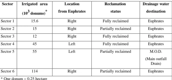
Table 1: Ramadi Irrigation Project Sectors (Al-Mehamdei, 2015; Al-Simawi, 2010).
Sector Irrigated area
(103 donums)* Location from Euphrates Reclamation status Drainage water destination
Sector 1 15.6 Right Fully reclaimed Euphrates
Sector 2 15 Right Partially reclaimed Euphrates
Sector 3 12 Right Fully reclaimed Euphrates
Sector 4 45 Left Fully reclaimed Euphrates
Sector 5 55 Left Partially reclaimed M.O.D.
(Main outfall Drain)
Sector 6 114 Right Partially reclaimed Euphrates
2.2 Fallujah-Ameriya Irrigation Project
This project is partially-reclaimed located on the right side of the Euphrates River. It comprises two sectors; the first extends from Khalidiya to Ameriyat-Al-Fallujah, while the second, which is relatively smaller, is located to the south of Ameriyat Al-Fallujah. The net area of the project is estimated at about 55,000 donums. Generally, the project is partially exploited and need a lot of work to complete the reclamation. The project depends on pumped water supply from the Euphrates for Irrigation, and pumping is also the method to discharge drainage water to Euphrates (Al-Simawi, 2010; Al-Simawi, 2011).
2.3 Jurf Al-Sakhar Irrigation Project
Jurf Al-Sakhar project is on the right side of the Euphrates River near Jurf Al-Sakhar town in Babylon Governorate. The project has a net area of 31,000 donums out of which more than 5,000 donums are orchards. The project is not reclaimed but cultivated and depends on pumping for its water supply, drainage water is also pumped to the Euphrates River (Al Mehamdei, 2015; Al-Simawi, 2010 &2011).
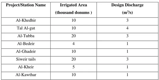
2.4 Small Projects in Muthana
Governorate Several small projects are depending in their water supply on pumping from the Euphrates River within Muthana governorate. These projects were implemented before 2003, at a time when agriculture was flourishing, and agrarian campaigns were active in the country. Table 2 manifest the details of these small projects.
Table 2: Pumping irrigation projects in Muthana governorate (Al-Simawi, 2011).
Project/Station Name Irrigated Area
(thousand donums ) Design Discharge (m3/s) Al-Khedhir 10 3 Tal Al-gut 10 4 Al-Tubba 20 3 Al-Bedeir 4 1 Al-Ghadeir 10 1 Siweir tails 20 3 Al-Kheir 5 1 Al-Kawthar 10 1
2.5 Muthana Irrigation Project
Muthana Irrigation project is one of the planned projects on the left side of Euphrates in Muthana Governorate, the project was studied by Swiss consultants in 1981. Net area at the time of development was 48,000 donums. The project now irrigated by a network of earth canals and privately owned pumps. In 2005, drainage network implementation was started to excavate the main drain and number of branch and secondary drains. Moreover, one maim pumping station was built to pump drainage water to the Eastern Euphrates Main Drain (Al-Simawi, 2010 & 2011).
3. Great Abu Ghraib Project
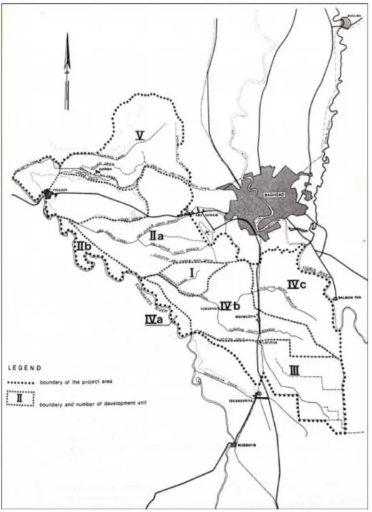
One of the major reclaimed and important irrigation projects on Euphrates is Great Abu Ghraib Project. It is located to the left side of the Euphrates River. It spreads from the left bank of the Tharthar-Euphrates Canal to Great Musayab Project. The project is bordered from the north by Tharthar-Tigris Canal, and from the east the city of Baghdad and Tigris River. Historically, there exist several very old canals on the left of Euphrates River which are: Saqlawiya, Abu Ghraib, Yusufiyah, Latifiyah and Eskandariah. These canals are thought to belong to the Babylonian era, and have continued service, with many changes throughout the Abbasid times until modern days. The first man who has thought of developing the project was Sir William Willcocks as documented in his well-known study in 1911, where he had suggested the construction of Fallujah Barrage and the combined head reach canal. Later on, the Higher Agricultural Council in the 70s, commissioned the Dutch company Nedeco to study the project. The studies and designs were started in 1975. Then, implementation was begun in 1979. Figure 1 shows a general map of Great Abu Ghraib Project (Willcocks, 1917; Board, 1977).
Figure 1: General map of Great Abu Ghraib Project. (Nedeco, 1978).
The fully developed area of the project is 572,000 donums. The implementation works were done in the beginning by foreign companies while Iraqi companies continued after that ( Iraqi Ministry of Water Resources, 2005). Great Abu Ghraib Project is a very large development project which comprises of the following parts:
3.1 Fallujah Barrage
Fallujah Barrage located at Euphrates River at a distance of 5km downstream the city of Fallujah. The barrage has 10 openings controlled by radial gates of dimensions (8.5 ×16)m. The maximum discharge of the barrage is 3600m3/s at the maximum operational level 44.79m a.s.l. There is fish ladder, and the navigational lock in the design which is supposed to be implemented in the future. The barrage is controlling the water flowing to the Combined Head Reach Canal, which is the backbone to the Great Abu Ghraib project. The Combined Head Reach Canal head regulator is located on the left side of Fallujah Barrage. It consists of four openings of dimensions (3.5×6) m and the operational discharge is 104m3/s (Al-Simawi, 2014; Nedeco, 1978). Figure 2 shows the upstream view of Fallujah Barrage and the Combined Head Reach Canal head regulator.
Figure 2: An upstream view of Fallujah Barrage and Combined Canal head regulator (Iraqi Ministry of Water Resources, 2019).
3.2 Combined Head Reach Canal
This is a 52km long earth canal. The several canals is branching from this main canal are Abu Ghraib, Radwaniyah, Yusufiyah and Latifiyah. At distance of 8km from the start of this canal, Abu Ghraib main canal is branching, where it takes a discharge of 28m3/s. Radwaniyah main canal branches of next with a discharge of 7.2m3/s. At the distance of 36km, Yusufiyah canal branches with a discharge of
24.4m3/s. Following that at a distance of 52km which is at the end of the canal, Latifiyah Canal is branching. The discharge capacity is 23m3/s, at the end also there is a side escape on the right side to bypass the excess water to Euphrates River.
3.3 Saqlawiya Irrigation Project
The Saqlawiya project is supplied from the Euphrates River, upstream of Fallujah Barrage at about 18km distance. The back water curve of Fallujah Barrage maintains the sufficient levels of water to direct the flow into the project by gravity. The net area of the project is 113,000 donums the total discharge is 26m3/s.
Saqlawiya main canal continued for 17km, branching at the end into two lined canals, the first is Ali Al-Suleiman Canal, which is 52km long and has 11m3/s discharge capacity. This canal irrigates an area of 76.5 thou donums, and the second canal is the 30km-long Ibrahim Al-Ali canal with discharge of 7m3/s. It irrigates an area of 49.5 thousand donums, and its main drain discharge is 24m3/s, where it serves part of Ramadi project. Finally it outflows by gravity into the Main Outfall Drain (MOD). The project is partially reclaimed at 25% level.
3.4 Abu Ghraib Irrigation Project
For clarification, the Abu Ghraib Project is the lands around Abu Ghraib city, which is a part of Great Abu Ghraib project. The main canal of the project is 18km long lined canal which carries a discharge of 28m3/s. At its end, the canal is branching into three canals, the northern canal has discharge of 7m3/s, the middle eastern canal has discharge of 8m3/s and the southern canal has a discharge of 7m3/s. Net area of the project is 170,000 donums, of which 92,000 dunams had equipped with field drains. The project is drained into M.O.D.
3.5 Fallujah Irrigation Project
The lands which belong to this project are comprised of all the area located between the right side of the Combined Head Reach Canal and the left side of Euphrates River in addition to the lands in the vicinity of the head of the Combined Canal itself. The project is area is totally irrigated by privately owned pumps. The net irrigated area is around 72,000 donums.
3.6 Radwaniyah Irrigation Project
Radwaniyah project is located between Abu Ghraib and Yusufiyah projects. The main canal is 9.5km long with discharge of 7.2m3/s. The project is fully developed, 29,000 dunams of the total area of 49,000 dunams was fully reclaimed and drainage network is linked to M.O.D.
3.7 Yusufiyah Project
Yusufiyah Old Canal was extending during past history from the Euphrates River to the Tigris River. The remains of the old Yusufiyah canal is still in existence and functions to supply part of the land with water. The new Yusufiyah project is bordered in the north by Abu Ghraib and Radwaniyah projects and to the south by Latifiyah project. After the development of Great Abu Ghraib project, the lands of Yusufiyah area were divided into two parts, the first which extend from the left side of the Euphrates to the Main Outfall Drain (M.O.D) is irrigated by the old and new
Yusufiyah canals and is called Yusufiyah Project. While the lands left of the (M.O.D) and up to Tigris River is irrigated through the old Yusufiyah Canal, as well as pumping stations on the Tigris River. This part is called Hour Rajab project. The new Yusufiyah canal discharge is 24.4m3/s while the net area of Yusufiyah project is 122,000 donums, of which 82,000 donums are supplied by concrete lined canals. A net area of 44,000 dunams have been fully reclaimed, and other areas are under development. The drainage system of the project is connected to the Main Outfall Drain (M.O.D).
3.8 Hour Rajab Project
The irrigated land of the project is at the east of M.O.D, to the west of the Tigris River. Its water is supplied from the old Yusufiyah Canal and many pumping stations on Tigris as part of Hour Rajab project. The net area of the project is 95,000 donums. Reclamation work in this project was started in 1999 when several pumping stations and lined canals were implemented. Drainage network connected to M.O.D.
3.9 Latifiyah Project
Latifiyah project is located to the south of the Yusufiyah project and is bordered to the east by M.O.D. and to the west and south by Eskandariah project. The project is mainly fed by the new lined Latifiyah Canal which branches from the end of the combined canal. Some of the lands are irrigated from the old Latifiyah Canal. The net area of the project is 103,000 donums. The new Latifiyah canal is 51km-long lined canal, and the old Latifiyah earth canal is 34km long. The area for which irrigation and drainage networks have been implemented has reached 80,000 donums.
3.10 Eskandariah Irrigation Project
The lands of Eskandariah project are located at the end of Great Abu Ghraib project. The initial design was to connect the old Eskandariah Canal with the Combined Head Reach Canal. Now, the project is supplied from the new Eskandariah Canal that branches from the new Latifiyah Canal at the 29km point. Eskandariah new canal discharge is 6.5m3/s. The area of the land irrigated from this canal is about 20.6 thousand the donums. Eskandariah old canal is partially lined and it is 18km long. The operation of the head regulator of this canal is partly affected by Hindiya Barrage and its discharge 8m3/s. Eskandariah old canal is serving an area of 15,750 dunams. The project is draining to M.O.D, and to the northern Musayab drain (Al-Simawi, 2010, 2011, 2014; Ministry of Irrigation, 2001; Directorate General of Irrigation, 1954; Sousa, 1946).
4. Great Musayab Project
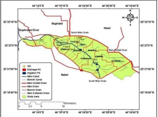
The Great Musayab project is one of the old projects where its land was irrigated from the old Cotha Canal of the Abbasid times. During first years of work of the Iraq Development Board in the 1950s, the Musayab project was the first project that was reclaimed in Iraq. Studies started since 1952, later on the development works were completed in 1956. Irrigation canals are all earthen canals, and the net area of the project is 250,000 donums; moreover, new area was added to the project, which was the Sumoud farm, it has a net area of 17,000 donums. Figure 3 shows the map of the Great Musayab Project. Drainage networks are connected to M.O.D. Great Musayab project generally needs now overall rehabilitation works, where the earth canals have their original profiles and cross sections and most of the small regulators are not in goods working order (Al-Simawi, 2010, 2011, 2014 ; Babylon, n.d.; Iraqi Ministry of Water Resources, 2005).
Figure 3: Map of the Great Musayab Project (Al-dabbas & Al-Ali, 2016).
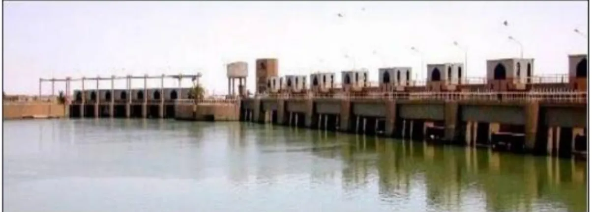
5. Hindiya Barrage
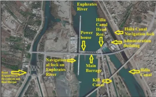
Hindiya Barrage is the oldest built barrage in the modern history of Iraq in an effort to overcome water shortage in Hilla Branch that was made by Ottoman authorities at the time. Two structures were built, the first was a weir, which could not stand for a long time, and the second was a regulator designed by Sir William Willcocks which was completed in 1913. This one still existing but it was decommissioned after it had worked for decades, and it passed and withstood many severe flood waves. The need to a new barrage was evident after this one had undergone deterioration. The Ministry of Irrigation then entrusted the French company Sogreah to prepare the designs and studies for a new structure to replace the old one. The work in the design was started in 1981. The construction contract was awarded to “The Chinese Engineering Company” which started the construction in 1984 and completed it in 1989. Hindiya Barrage project consists of the main barrage, a hydroelectric station, navigational locks, with the head regulators for of the Hilla Branch, Kifl Canal, Hussainiya and Bani Hassan Canal. The new barrage is located 1.7km upstream of the old barrage, and as shown in Figure 4, its various parts are indicated and detailed as follows:
1. Main Barrage: It is a concrete structure with 6 openings of dimensions (6.75×16)m controlled by radial gates, maximum discharge is 2,500m3/s at the maximum water level of 32.55m a.s.l. On the right side, the Hydroelectric Power station is located which is equipped by four units with total capacity of 15 megawatts and discharge of 420m3/s. beside the station, the navigational lock is located with dimensions of (20x150)m and there is also the fish ladder.
2. Hilla Branch Main Regulator: to the left of the main barrage the Hilla Branch Main Head Regulator is placed which has six openings with dimensions of (5.4×6)m and controlled by radial gates. The maximum discharge of the regulator is 326m3/s, while normal discharge is 200m3/s. To the left of the
regulator is an island within the river where the administration building compound was built there. To the left of the island, a 600-meter navigational channel linking Hilla Branch and Euphrates River, in this reach there is a navigational lock with dimensions of (6×90)m. Figure 4 shows the details of Hindiya Barrage.
Figure 4: Details of Hindiya Barrage complex (Abdullah, Al-Ansari, & Laue, 2019).
3. Kifl Canal Head Regulator: this regulator is located between Hindiya Barrage and Hilla Branch Main Regulator, it consists of two openings with dimensions of (3.4×4.5)m. The maximum discharge of this structure is 36.12m3/s and its normal discharge is 20m3/s.
4. Bani Hassan Head Regulator: to the right side of Hindiya Barrage. At the upstream there is the closure dykes of the abandoned river reach, then a connecting canal leading to the head regulators of Hussainiya Canal and Bani Hassan Canal. Bani Hassan head regulator is consisting of two openings of dimensions (3.4×6)m, with the maximum discharge of 45m3/s. 5. Hussainiya Head Regulator: This regulator is on the right side of Bani
Hassan Head Regulator. It consists 3 openings of dimensions (3.4×6)m. The maximum discharge of the regulator is 55m3/s, and the normal discharge is 32m3/s (Iraqi Ministry of Water Resources; 2005; Simawi, 2014; Al-Simawi, 2010).
6. Eskandariah-Mahawel Project
Eskandariah-Mahawel project is bound by Eskandariah project and Great Musayab projects to the east, Euphrates River to the west, and Hilla Branch and Babil Canal to the south. The project is divided into three phases:
Phase 1: The land which is irrigated mainly from Hilla Branch upstream Babil
Canal, the area is 125,000 donums.
Phase 2: This phase is irrigated from Nasiriya Canal; this phase is fully
reclaimed and its area is13,000 donums. Command area of this phase is located south of Musayab Canal; the canal of Nasiriya branches from the left side of the Euphrates River at a distance of 8km upstream of Hindiya Barrage; the canal discharge is 4.7m3/s. The drainage network flows are discharged into the
Southern Musayab Drain by the Kish pumping station.
Phase 3: Lands of this phase are bound by Eskandariah canal and Musayab
canal and are irrigated by privately owned pumps installed on the left side of Euphrates. Area of this phase is 25.7 thousand donums (Al-Simawi, 2011& 2014; Mousa, 2017).
7. Husseinia and Bani Hassan Projects
Unlike other main cities in Mesopotamia, Karbala was not built on any river or canal. Hence, after commissioning Hindiya Barrage, canals were excavated to take water to Karbala and its orchards. Bani Hassan Canal is also to irrigate the lands to the right side of Euphrates downstream Hindiya Barrage. The Development Board had entrusted Nedeco with the study of the development of the project from 1954 to 1956. Many other consultants prepared more studies and designs for this project later on. The project is divided into two main parts:
7.1 Husseinia Project
Husseinia Canal is the backbone of the project, it has been lined recently. The canal is 28km long and its maximum discharge is 55m3/s. Net area of the project is
112.5 thousand donums, of which 56,000 donums are orchards. Drainage network covers an area of 96,000 donums of the total project area and its drainage flows are collected in a main drain which ends with pumping station to lift the drainage water in to the Razzaza Lake. The city of Karbala is suffering from the rise in groundwater levels unless continuous pumping of drainage water is done, hence, the drainage system is a mitigation action for this issue.
7.2 Bani Hassan Project
The project is bound by the. Euphrates River and Karbala-Najaf main road. The project is mainly fed from the newly-lined Bani Hassan Canal. This canal has a length is of 68km, its maximum discharge is 45m3/s. The net area of the project is 105.5 thousand donums. The drainage systems is served by several pumping stations that discharge into the Euphrates River (Al-Simawi, 2010. 2011&2014;
Board, 1977; Directorate General of Irrigation, 1954).
8. Hilla-Kifl Project
This project is among the old projects which is irrigated by Kifl Canal. The project is located between Hindiya Barrage and Kifl City, bordered to the west by Euphrates River and to the east by Hilla Branch and Hilla-Kifl road.
The first works in the project was Tewerej drainage network, this was implemented in 1954. Also, Nedeco conducted a study and designs for the drains of Hilla-Kifl, so the 55.5km-long Hilla-Kifl main drain was completed in 1959. The project was later on studied by the Swiss consultants Consortium in 1984. Reclamation work was started in 1982 for the middle and north sectors of the project. After 2006, the reclamation of the southern sector was started, as well as the lining of Kifl Canal itself, this is still going on now. Net area of the project is 152,000 donums. After the development of the project, it is now irrigated by three main canals, which are:
1. Pumping canal: 17.74km lined canal which is supplied with water by pumping station built to pump water from the Kifl Canal.
2. Hilla Canal: 51km lined canal with discharge of 14.2m3/s. This canal passes at the center of the project and its route is adjacent to Hilla city and the eastern edge of the project.
3. The Kifl Canal: the upper reach of the canal is 6.9km long and is considered as the main canal that feeds the Pumping canal and Hilla canal, the route of the old canal is the same of the current canal of Kifl, which has been partially lined. The canal is 50.25 km long with a discharge capacity of 18.5m3/s. The canal runs along the Euphrates River and ends at the city of Kifl.
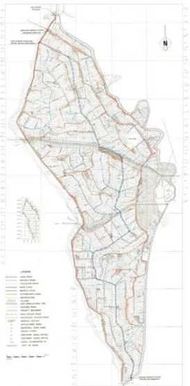
Drainage network discharges to the Eastern Shamia drain, through the main Hilla-Kifl drain which is the backbone of the project to for draining the lands. Figure 5 shows a map of Hilla-Kifl project (Al-Simawi, 2011, 2014; Iraqi Ministry of Water Resources, 2005; Babylon, n.d.; Mahmoud, 2011).
9. Hilla Branch Projects
Hilla Branch and its extension of Shatt Al- Diwaniyah is an ancient courses of the Euphrates River; also, it is the most important branch of the Euphrates River in Mesopotamia now. Hilla Diwaniyah area was studied by Nedeco for the first time from 1958 to 1960, dividing the project into four sectors. Nedeco again submitted a study on the drainage network in the region in 1972. Then another study was presented also by Nedeco in 1986 which included nine sectors; three of them are on the right side of Hilla Branch, another three are at the right side of Shatt Al- Daghara while the last three are located at the left of Shatt Al-Daghara. Later on, the project was divided into two projects along Hilla Branch, the first is on the left which is Hashimia project, and the second is to the right side which is the Hilla-Diwaniyah project. At the lower reach projects are assigned to the Hurriyah-Dagharra project, and they are fed from Shatt AlHurriyah-Dagharra, and Shatt Al-Diwaniyah
project as well as Rumaitha project at the far end of Hilla Branch command area. In the upper reach, projects are presented below.
Figure 5: Hilla-Kifl Irrigation Project map (Mahmoud, 2011). 9.1 Hilla Branch
The length of Hilla Branch is 101km. The maximum discharge of this canal is 245m3/s. It was planned so that its capacity can be increased to pass a 300m3/s.
Along Hilla Branch, the following regulators have been constructed:
a. Doora Regulator, at the km 51.1 of the canal. The regulator consists of six openings with dimensions (6×9)m each, maximum discharge is 249m3/s. To the right of the regulator is a 6×90m navigation lock, the regulator was inaugurated in 1981.
b. Al-Tayas Regulator, at km 76km of the canal. The regulator consists of five openings with dimensions (6×9)m, its maximum discharge is 206m3/s. To the right of the regulator is a 6×90m navigation lock. The regulator was inaugurated in 1982.
c. Shatt Al-Diwaniyah Head Regulator: this regulator together with head regulator of Shatt Al-Daghara were inaugurated in 1928. These new regulators been re-built were built as replacements to the old ones. New Shatt Al-Diwaniyah head regulator was inaugurated in 2010, it consists of four openings of dimensions (3.75×6)m and controlled by radial gates, the maximum discharge is 96m3/s. d. Shatt Daghara Head Regulator: The new regulator of Shatt
Al-Daghara was inaugurated in 1980 and is located upstream of Shatt Al-Diwaniyah Head Regulator, it has three openings with dimensions (4×6)m, and it is controlled by radial gates, maximum discharge is 96m3/s, while the normal discharge is 55m3/s.
9.2 Hilla-Hashimia Project
The Euphrates Center for Studies and Design prepared a study of the integrated irrigation and drainage network for the project in 1990. Drainage network down to the collector drains were was implemented between 1993 and 1995. Additionally, a drainage pumping station, was constructed in 1996. The irrigated area covered by the project's canals network is 410,000 donums, of which 240,000 donums are covered by drainage network. Irrigation network is mainly of earth canals. The discharge of the drainage system flows into the M.O.D.
9.3 Hilla-Diwaniyah Project
The net area of Hilla-Diwaniyah project is 282,000 donums. Development of the project was done by the Greek company Scapaneus, work was started in 1975, but the project is still a partially-reclaimed project. Most of the irrigation canals are earth canals. The drainage network is connected to East Shamiya drain (Iraqi Ministry of Water Resources,2005; Al-Simawi, 2011& 2014; Board, 1977; Mousa, 2017).
10. Hurriya-Daghara Project
As mentioned already in paragraph (9), the backbone for this irrigation network is Shatt AlDaghara, in addition to Dhulmia Canal and Hurriya Canal which are branching from Hilla Branch and Sharifiya Canal, which itself is branches from the left side of Shatt Al-Diwaniyah. This project is covering six sectors of the Hilla-Diwaniyah-Daghara project. Most of the project's area is served by old canals and there are some reclaimed sectors. Net area of the project is approximately 643,000 donums. One of the best sectors of project in terms completeness of lining and reclamation is Sector 4, which includes Thuraima Canal and Right Jannabia Canal with the full reclamation for an area of 65,000 donums. The development of Sector 7 of the project was started in 2001 and is still under way. The project is covered by a large drainage network that collects and discharge drainage water to the M.O.D. Two main drains are serving the project, the first drain is MD III to the left of Shatt al-Daghara, the length of which is approximately 75km, and the second
drain is MD IV to the right of Shatt al-Daghara whose length is approximately 53km( Iraqi Ministry of Water Resources; 2005;Simawi, 2011, 2014, 2015; Al-Musawi, 2015; Al-Zamilie, 2017).
11. Shatt Al-Diwaniya Projects
From the end of Hilla Branch, Shatt Al-Diwaniya continues for a distance of approximately 120km with discharge capacity of 60m3/s. One cross regulator on the canal is located in Siniya sub-district at the km 34.5. The construction of the new Shatt- Al Diwaniya Head Regulated, with increased discharge capacity, resulted in raising the ground water level in Diwaniya city itself. This situation led to the excavation of Shatt Al-Diwaniya Diversion Canal, which helped also in securing water to the cities located downstream. This new canal is 27.9km long and it has 45 m3/s discharge capacity and it was lined. Upstream Siniya regulator, there is also the new Shafiya Canal which is branching from the right side of the Shatt Al- Diwaniya. It has a length is 30km and discharge of 15.7m3/s. The old Shafiya Canal,
an earth canal branching at km 35.82km from Shatt Al- Diwaniya is 7.8km long and its discharge 1m3/s. The remaining part within Diwaniya and Hamza districts is irrigated by earth canals and privately owned pumping stations (Al-Simawi, 2010& 2014; Al-Zamilie, 2017).
12. Rumaitha Irrigation Project
This is one of the old existing projects at the tails of Hilla Branch, whereby the General Irrigation Directorate had developed an irrigation system from 1940 to 1954. The project has two parts, the first is a 144,000 donums area for winter irrigation, and the second has an area of 35,500 donums reserved for summer irrigation. The irrigation system within the project consists of several canals. The project was studied by NESPAK, a consulting company from Pakistan which drew up plans for the necessary lining and reclamation works. In 1971, Dar Baghdad, another consultant prepared also a study the project main drains, consisting of the Main Rumaitha Drain with a length of 58km, the Main Qazweini Drain with a length of 38km, and the Eastern Drain with length of 37.5km. Excavations of the main drains for the project were implemented. These drains are connected now to the Eastern Euphrates Drain (Al-Simawi, 2011, 2014; Directorate General of Irrigation, 1954; Ministry of Irrigation, 2001).
13. Kifl-Shinafiyah project
The project begins at the branching point of the Euphrates River near Kifl city to Kufa and Shamiya Branches and ends when they meet again near the city of Shinafiyah. The project is an important one and socially complex. The Iraq Development Board had tasked in 1958 TAMS, an American consulting company to study the project area for the purpose of developing river navigation. From 1975 to 1978, Selkhozpormexport from the previous USSR conducted investigations and more studies to develop the area and submitted its report in 1980. Following this a French Consultant named SOGREH made the designs of the regulator on Kufa and Shamiya Branches, while there were already regulators at the end of Kufa Branch which were built during the 1930s and 1950s. The designs of the main drains for the project were developed by NESPAK, namely the Eastern Euphrates, Western Shamiya and the Najaf Sea Drains. And the Indian consultant WAPCOS prepared the designs of the irrigation and drainage networks for the project, and their report was submitted in 1983. According to the WAPCOS report, the net area of the project is 664,000 donums. One of the important phenomena prevalent in this region is what is known as the (Nagarat) phenomenon, which is a drop developing as a result of erosion in the river bed which retrogrades upstream causing a decrease in the levels of rivers and affecting irrigation. The project has a number of major barrages and regulators, and it is considered that the navigation route shall be along the Kufa Branch as this branch is the larger one and it is more suitable for navigation. The Barrages in the project are Kuafa, Meshkhab and Abu Ashraa Barrages, while the main regulators are Abbasiya, Shamiya, Khawarnaq and Al-Ya'aw Regulators. The details of these Barrages and Regulators are as follows:
13.1 Shamiya Branch regulators
The regulators on Shamiya Branch are:
1. Abbasiyah Regulator: it is the first regulator on Shamiya Branch, located upstream of Abbasiyah city. SOGREH, a French Company had designed this regulator with the other ones in the area. This structure was constructed by the Chinese Company for Engineering Construction with the other regulators the 1980s. Abbasiyah Regulator was inaugurated in 1988. It consists of six openings of dimensions (6.3×12)m and controlled by radial gates, maximum discharge is 1100m3/s. The regulator has also a fish ladder. 2. Shamiya Regulator: it is located upstream of Shamiya city at the km 39 of
Shamiya Branch, it was inaugurated in 1986. This regulator has six openings of dimensions (6.3×12)m which are controlled by radial gates. Its maximum discharge is 1100m3/s. The regulator has a fish ladder.
3. Khawarnaq Regulator: it is located upstream of Ghamas city at the km 69 km of Shamiya Branch, and it was inaugurated in 1986. It has five openings of dimensions (8×8)m. The regulator is controlled by radial gates and its' maximum discharge 1100m3/s and it has a fish ladder.
13.2 Kufa Branch Barrages
The Barrages and Regulators built on this branch are:
1. Kuafa Barrage: It is the first structure on Kufa Branch. It was designed and constructed by the same companies that had designed and built the other hydraulic structures in the area during the 1980s. Kufa Barrage was inaugurated in 1988. It has seven openings with dimensions of (6.3×12)m. The barrage is controlled by radial gates and it has maximum discharge of 1400m3/s. The regulator includes a fish ladder and a navigational lock with
dimensions of (20×150)m. The barrage includes also a hydroelectric power station equipped with four units of total capacity of six megawatts. 2. Meshkhab Barrage: It is located in Meshkhab city, the barrage was built in
1959. It consists of seven openings of width 12.55m each. The discharge is controlled by vertical lift gates and pass maximum discharge of 750m3/s. It includes a fish ladder and a navigational lock with dimensions of (8×80)m. 3. Abu Ashraa Regulator: This is one of the older regulators and it is located
near Qadisiyah sub-district. It was completed in 1936, a drop structure had been added to it which was and completed in 1939. The regulator consists of four openings with dimensions of (2.5×3)m which are controlled by vertical lift gates; the maximum discharge is 50m3/s. On the left of the regulator there is navigation lock with dimensions of (6×105.75)m. 4. Al-Ya'aw Regulator: It is also one of the old regulators, which is located on
the head of AlYa'aw River which branches from a point 5 km upstream of Abu Ashraa regulator to the left. This regulator was completed by Balfour Beatty in 1940 and, it consists of seven openings with dimensions of (2.5×3) m; the maximum discharge is 200m3/s (Al-Simawi, 2010, 2011, 2014;
Directorate General of Irrigation, 1954; Iraqi Ministry of Water Resources, 2005; Elaiwy, 2018; Sousa, 1946).
14. Euphrates Tail System
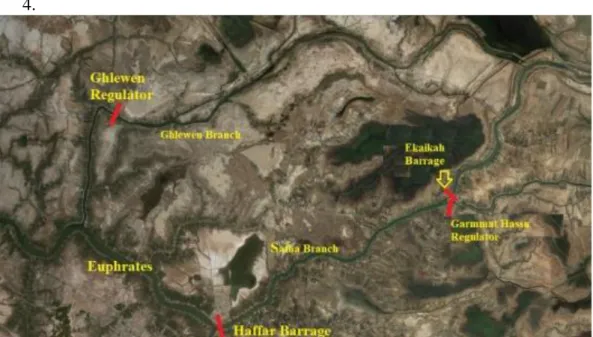
At Souq Al-Shouyokh area the Euphrates bifurcates to several branches. Many hydraulic structures have been built here in the late 1950s and 1960s to control the water distribution to the farmlands. Figure 6 shows the main structures on the Euphrates near Souq Al-Shouyokh. The main control structures in this part of Euphrates River are:
1. Ghlewen Head Regulator: the Ghlewen Branch from the Euphrates River at a point nine kilometers distant upstream of Suq Al- Shoyokh city. This branch meets with Euphrates River near Al Fuhood sub-district. The discharge of this branch is controlled by Ghlewen Regulator, which consists of five openings discharging 250m3/s, the regulator was built in 1968. 2. Ekaikah Barrage: The Safha Branch is branching from the left of Euphrates
River at approximately 2km upstream Suq Al-Shoyokh city, the length of Safha branch is 10km and at the end there is Ekaikah Barrage, which consists of five openings of total discharge of 300m3/s. The barrage has a
fish ladder and navigational lock with dimensions of (8x60)m. To the left of Ekaikah Barrage, there is Garmat Hassan Regulator, which has three openings of total discharge capacity of 100 m3/s. Both Structures were inaugurated in 1957. Ekaikah Branch outflows in Ghlewen branch, while Garmat Hassan Branch outflows into the Euphrates River at Al-Taar city. 3. Haffar Barrage: It is the last Barrage on Euphrates River before its
confluence with Tigris River in Qurna. The Barrage was built near Bani Se'id city in 1957, it consists of seven openings, the discharge capacity is 500m3/s, in addition to fish ladder and navigational lock of dimensions (8×60)m (Al-Simawi, 2010 & 2014).
4.
Figure 6: Main structures at Euphrates near Souq Al-Shouyokh. (Esri, 2019). (Edited by Author).
15. Conclusions
It can be concluded from the existing status of major irrigation system on Euphrates within at Mesopotamia the following main points:
1. Projects in the upper parts of Mesopotamia are more developed and level of reclamation is more than the lower parts.
2. Many projects, especially on the left side of Euphrates are discharging drainage water to Euphrates itself with no other alternative.
3. Although infrastructure for navigation were built, but were not utilized in the last recent years.
4. Most of the lands are irrigated by gravity, while some irrigated is being done by pumping. This is due to successful planning and implementation of the barrages and regulators.
References
[1] Abdullah, M., Al-Ansari, N. and Laue, J. (2019). Water Resources Projects in Iraq : Barrages. Journal of Earth Sciences and Geotechnical Engineering, Vol.9, Issue 4, 2019, pp. 153-167.
[2] Al-dabbas, M. A., and Al-Ali, E. A. (2016). Computation of Climatic Water Balance for Greater Musaiyab Project Site in Babylon Governorate-Central of Iraq. Iraqi Journal of Science, Vol. 57, 2, pp. 1445–1451.
[3] Al-Mehamdei, M. A. H. (2015). Integrated Management of Water Resources in Anbar Governorate. Doctorate Dissertation, University of Saint Clements, Columbia.
[4] Al-Musawi, D. M. (2015). Hydrology of Shatt Al-Daghara, Study in Natural Geography. MSc Thesis (unpublished), University of Qadisiyah, Qadisiyah, Iraq.
[5] Al-Simawi, H. (2010). Irrigation and Drainage Projects in Iraq. Library of the Ministry of Water Resources, Baghdad, Iraq.
[6] Al-Simawi, H. (2011). Irrigation and Drainage Pumping Stations in Iraq. Library of the Ministry of Water Resources, Baghdad, Iraq.
[7] Al-Simawi, H. (2014). Irrigation Regulators in Iraq until the end of the year 2013. Library of the Ministry of Water Resources, Baghdad, Iraq.
[8] AL-Simawi, H. (2011). Large Main Drains in Iraq and their Status until 2011. Library of the Ministry of Water Resources, Baghdad, Iraq.
[9] Al-Zamilie, K. H. (2017). Spatial Analysis of Agricultural Land Use in Diwaniyah District. MSc. Thesis (unpublished), University of Qadisiyah, Qadisiyah ,Iraq.
[10] Babylon, W. R. D. (2019). Water Resources Directorate in Babylon Website. Retrieved June 1, 2019, from http://babilresource.net/
[11] Board, S. A. (1977). Large and Medium Agricultural Projects. Supreme Agricultural Board, Baghdad, Iraq.
[12] Directorate General of Irrigation (1954). Report about Directorate General of Irrigation Works for a Five Years from 1949 to 1954. Ministry of Irrigation, Baghdad, Iraq.
[13] Esri (2019). ArcGIS Online. Retrieved June 13, 2019, https://www.esri.com/enus/arcgis/products/arcgis-online/overview
[14] Mahmoud, A. H. (2011). Evaluating the Feasibility Study of Hilla - Kifl Irrigation Project. Iraqi Journal of Civil Engineering, Vol.11, 3, 2017, pp. 18-31.
[15] Ministry of Irrigation (2001). The Implemented Projects from 1/1/1996 to 1/6/2001. Library of the Ministry of Irrigation, Baghdad.
[16] Mousa, Z. A. (2017). Geographical evaluation of Irrigation and Drainage Network in Babylon Governorate (in Arabic). Journal of the College of Education and Humanitarian Sciences/ University of Babylon, Vol.13, 2017 pp. 523-548.
[17] Nedeco (1978). Abu Ghraib Project: Planning Report, Volume IV. Ministry of Irrigation, Baghdad. Where is it published?
[18] Iraqi Ministry of Water Resources (2019). Ministry of Water Resources Official Page on Facebook. Retrieved June 14, 2019, from https://www.facebook.com/waterresources2/
[19] Iraqi Ministry of Water Resources (2005). The Encyclopedia of Irrigation in Iraq, February 1918-February 2005, Library of the Ministry of Water Resources, Baghdad, Iraq.
[20] Sousa, A. (1946). Irrigation Development in Iraq, Second Edition, Al-Adeeb Publishers, Baghdad, p. 136 ( in Arabic).
[21] Willcocks, W. (1917). Irrigation of Mesopotamia, 2nd Edition, E & F.N. Spon Ltd., London.