Sustainable smart-parking
management for connected and
autonomous vehicles
Fo
to: F
ot
ograf Satu AB, V
TI VTI rapport 1033APublished 2020
vti.se/publications Sogol Kharrazi
VTI rapport 1033A
Sustainable smart-parking management
for connected and autonomous vehicles
Sogol Kharrazi
Yacine Atif
Author: Sogol Kharrazi, VTI, Yacine Atif, University of Skövde Reg. No., VTI: 2017/0572-8.2
Publication No.: VTI rapport 1033A Published by VTI, 2020
VTI rapport 1033A
Abstract
This report addresses the parking-seeking problem and suggests a smart parking algorithm that can guide vehicles to the best parking lot in a parking area, minimizing travel time and maximizing chances of finding an available spot. The developed algorithm exploits data available from connected and smart parking and road infrastructure, using an optimization algorithm based on a multicriteria decision-making process. The project was financed by Vinnova and was a collaboration between VTI, University of Skövde, Stockholm City, Stockholm Parking and Kista Science City.
Title: Sustainable smart-parking management for connected and autonomous vehicles
Author: Sogol Kharrazi, (VTI, https://orcid.org/0000-0002-7780-7449 )
Yacine Atif (University of Skövde,
https://orcid.org/0000-0002-7312-9089)
Publisher: Swedish National Road and Transport Research Institute (VTI) www.vti.se
Publication No.: VTI rapport 1033A Published: 2020
Reg. No., VTI: 2017/0572-8.2
ISSN: 0347–6030
Project:
Sustainable traffic of autonomous vehicles in smart-parking
management
Commissioned by: Vinnova
Keywords: parking, connected vehicle, smart infrastructure, predictive analytics, Markov-chain, SUMO, traffic simulation
Language: English No. of pages: 29
VTI rapport 1033A
Referat
Rapporten avhandlar problemet med att leta ledig parkering och föreslår en smart parkeringsalgoritm som kan vägleda fordonen till den bästa parkeringen i ett område och därmed minimerar restiden och maximerar chansen att hitta en tillgänglig plats. Den framtagna algoritmen använder data som finns tillgänglig från den uppkopplade parkeringen och väginfrastrukturen tillsammans med en
optimeringsalgoritm baserad på en beslutsfattandeprocess innehållande flera kriterier. Projektet finansierades av Vinnova och var ett samarbete mellan VTI, Högskolan i Skövde, Stockholm City, Stockholm Parkering och Kista Science City.
Titel: Hållbar, smart parkeringskoordinering för uppkopplade och autonoma fordon
Författare: Sogol Kharrazi , (VTI, https://orcid.org/0000-0002-7780-7449) Yacine Atif (University of Skövde,
https://orcid.org/0000-0002-7312-9089)
Utgivare: VTI, Statens väg- och transportforskningsinstitut www.vti.se
Serie och nr: VTI rapport 1033A Utgivningsår: 2020
VTI:s diarienr: 2017/0572-8.2
ISSN: 0347–6030
Projektnamn: Hållbar, smart parkeringskoordinering för uppkopplade och autonoma fordon
Uppdragsgivare: Vinnova
Nyckelord: parkering, uppkopplade fordon, smart infrastruktur, prediktiv analys, Markov-kedjemodell, SUMO, trafiksimulering
Språk: Engelska
VTI rapport 1033A
Preface
SmartPark - Sustainable traffic of autonomous vehicles in smart-parking management, was a collaborative project between the Swedish National Road and Transport Research Institute (VTI), University of Skövde, Kista Science City AB, Sockholms stad and Stockholm Parkering AB. In short, the scope of the project was to develop and test an algorithm that guides a vehicle to an available parking spot near the desired destination. Proof-of-concept was done in a virtual setting, as no infrastructure to enable this is in operation yet.
Thanks to the project partners, who generously shared data on traffic and parking, modeling and simulation were successful, and the SmartPark algorithm could be tested and evaluated. As a result, several important conclusions could be made about its performance. The project team hope that the findings in this project will be used to guide further development of the SmartPark functionality. Thanks to all participants at meetings, seminars and demonstrations, for your contributions and interesting discussions.
Participants from VTI were Fredrik Bruzelius (who was the first project manager), Arne Nåbo (second project manager), Sogol Kharrazi, Anders Lindström and Björn Lidestam.
Participants from The University of Skövde were Yacine Atif, Sten F Andler and Jianguo Ding. Participants from Kista Science City AB were Åke Lindström, Sara Nozkova and Emma Karlsson. Participants from Stockholms stad were Thomas Sjöström, Per Karlsson, Camilla Wikström, Eva Sunnerstedt, Jakob Jonsson and Tommy Jakobsson.
Participants from Stockholm Parkering AB were Johan von Post and Fredrik Sjöholm.
The project was financially supported by the Strategic vehicle research and innovation programme (FFI), managed by the Swedish Governmental Agency for Innovation Systems (Vinnova).
Linköping, January 2020
Arne Nåbo Project leader
VTI rapport 1033A
Quality review
External peer review was performed on 12 February 2020 by Sten F Andler, University of Skövde. Sogol Kharrazi has made alterations to the final manuscript of the report. The research director Arne Nåbo examined and approved the report for publication on 25 February 2020. The conclusions and recommendations expressed are the authors’ and do not necessarily reflect VTI’s opinion as an authority.
Kvalitetsgranskning
Extern peer review har genomförts 12 februari 2020 av Sten F Andler, Högskolan i Skövde. Sogol Kharrazi har genomfört justeringar av slutligt rapportmanus. Forskningschef Arne Nåbo har därefter granskat och godkänt publikationen för publicering 25 februari 2020. De slutsatser och
rekommendationer som uttrycks är författarnas egna och speglar inte nödvändigtvis myndigheten VTI:s uppfattning.
VTI rapport 1033A
Contents
Summary ...9 Sammanfattning ...11 1. Introduction ...13 2. SmartPark algorithm ...15 2.1. Multicriteria decision-making ...15 2.2. Predictive analytics ...15 2.3. Algorithm assumptions ...162.4. Parking area representation ...16
2.5. Vehicle routing ...17
2.6. Historical data representation and state modeling...18
3. Evaluation of the SmartPark algorithm ...20
3.1. Geographical area selection ...20
3.2. Simulation set-up ...21
3.3. Evaluation results ...21
3.4. Demonstration in SUMO ...24
4. Conclusions ...26
VTI rapport 1033A 9
Summary
Sustainable smart-parking management for connected and autonomous vehicles by Sogol Kharrazi (VTI) and Yacine Atif (University of Skövde)
Traffic induced by parking-spot seekers is a growing challenge and constitutes a considerable portion of the traffic in city centers. New opportunities to solve this problem are emerging by connected vehicles and infrastructure. For instance, ultrasonic and magnetic sensors are already mounted on the ceiling of many parking lots to detect the availability of a parking spot. These sensors can provide parking spot availability information in real-time. Further, traffic-aware smart sensors which can detect the movement of individual vehicles are also available in many city and highway areas. This report suggests an algorithm for a cloud-based parking service that exploits these streams of data to choose the best parking lot in a given parking area.
The parking seeking problem is subject to a range of criteria that may include user, municipality and parking operator preferences. Users may have some preferences with respect to walking distance to destination. Municipalities prefer to spread the traffic to reduce congestion in the urban core. Parking operators seek to maximize parking lot utilization in order to increase the revenue on real-estate investments. To solve this problem, an optimization algorithm based on multicriteria decision making process is used.
The proposed SmartPark algorithm employs a discrete Markov-chain model to demystify the future state of a parking lot. The algorithm features three modular sections:
• First, a search process is triggered to identify the expected arrival time periods to all parking lots in the targeted parking area. This process utilizes smart pole data streams reporting congestion rates across the targeted parking area.
• Then, a predictive analytics phase uses consolidated historical data about past parking dynamics to infer a state transition matrix, showing the transformation of available spots in a parking lot over short periods of time.
• Finally, this matrix is projected against similar future seasonal periods to predict the actual vacancy of a parking lot at the arrival time.
The performance of the proposed SmartPark algorithm is simulated and evaluated in the Kista district in Stockholm. Additionally, a baseline parking search behavior, referred to as BlindPark algorithm, is simulated and compared with the SmartPark algorithm. In the BlindPark algorithm, the vehicle is driven to the nearest parking lot, in the hope of reducing driving time. SmartPark and BlindPark algorithms are simulated and compared with a varying number of parking lots in the parking area, as well as under varying congestion rate situations. The simulation results illustrate a clear advantage of the SmartPark algorithm. The performance of the SmartPark algorithm versus the BlindPark algorithm is also demonstrated in a traffic simulation tool called SUMO (Simulation of Urban Mobility), which confirmed the simulation outcomes.
The project was financed by Vinnova (grant number 2017-03028) and coordinated by VTI. Other partners in the project were University of Skövde, Stockholm City, Stockholm Parking and Kista Science City.
VTI rapport 1033A 11
Sammanfattning
Hållbar, smart parkeringskoordinering för uppkopplade och autonoma fordon av Sogol Kharrazi (VTI) och Yacine Atif (Högskolan i Skövde)
Trafik som består av sökande efter parkeringsplats är ett växande problem och utgör en avsevärd del av trafiken i stadskärnor. Nya möjligheter att lösa detta problem kommer dock finnas när fordonen är uppkopplade till infrastrukturen. Till exempel, ultraljudsensorer och magnetiska sensorer är redan monterade i taket på många parkeringshus för att detektera tillgängligheten av en parkeringsplats, och dessa sensorer kan ge information om lediga parkeringsplatser i realtid. Vidare, smarta sensorer för trafikmätning, som också kan se förflyttning av enskilda fordon, finns redan i många städer och på motorvägar. Denna rapport föreslår en algoritm till en molnbaserad parkeringstjänst som använder ovanstående typ av data för att välja den bästa parkeringen i ett visst parkeringsområde.
Lösningen på problemet att välja bästa parkering omfattar en rad kriterier som kan inkludera preferenser från användare, kommuner och parkeringsbolag. Användare kan till exempel ha vissa preferenser med avseende på gångavstånd till destinationen, kommuner kan föredra att sprida trafiken för att minska trafikstockningarna i stadskärnan och parkeringsbolag försöker maximera parkeringars utnyttjandegrad för att öka avkastningen på fastighetsinvesteringar. För att lösa detta parkerings-problem användes en optimeringsalgoritm baserad på en beslutsprocess med flera kriterier.
Den föreslagna SmartPark algoritmen använder en diskret Markov-kedjemodell för att prognosticera det framtida tillståndet för en parkeringsplats. Algoritmen innehåller tre modulära delar:
• Först används en sökprocess för att identifiera de förväntade ankomsttiderna på alla
parkeringsplatser i det önskade parkeringsområdet. Denna process använder data från smarta stolpar som mäter trafik och trängsel inom parkeringsområdet.
• Sedan görs en prediktiv analys med hjälp av sammanställda historiska data över tidigare parkeringsanvändning för att skapa en matris som visar förändringen av tillgängliga platser på en parkeringsplats över kortare tidsperioder.
• Till sist används matrisen tillsammans med data om säsongsvariationer för att prediktera ledigheten av en parkeringsplats vid tiden för den beräknade ankomsten.
Prestandan på den föreslagna SmartPark-algoritmen simulerades och utvärderades i Kistaområdet i Stockholm. Dessutom var ett normalt sökande efter parkering, kallat ”BlindPark-algoritm” också simulerat och jämfördes med SmartPark-algoritmen. I BlindPark-algoritmen kör fordonet till den närmaste parkeringsplatsen i hopp om att erhålla den kortaste körtiden. SmartPark- och BlindPark-algoritmerna simulerades och jämfördes med varierande antal parkeringsplatser i parkeringsområdet, samt under varierande trängsel i trafiken. Simuleringsresultaten visar på en klar fördel med SmartPark-algoritmen. Utförandet och prestandan av SmartPark-algoritmen kontra BlindPark-algoritmen visades också i ett trafiksimuleringsverktyg som heter SUMO (simulering av urban rörlighet), som bekräftade simuleringsresultatet.
Projektet finansierades av Vinnova (bidragsnummer 2017-03028) och koordinerades av VTI. Andra partners i projektet var Högskolan i Skövde, Stockholm Stad, Stockholm Parkering och Kista Science City.
VTI rapport 1033A 13
1.
Introduction
Finding a parking spot in urban areas is a growing challenge, because of increasing congestion and scarcity of parking spots in major cities. Parking search traffic constitutes a considerable portion of the traffic in city centers, e.g. in a review by Shoup (2007) it is stated that sixteen studies of cruising behavior were conducted between 1927 and 2001 in the central business districts of eleven cities on four continents, the average time it took to find a curb space was eight minutes, and about thirty percent of the cars in the traffic flow were cruising for parking. A similar study in Paris (Gantelet & Lefauconnier 2006) reports an average time of 10 min spent in search of a parking spot.
However, recent advances in automated driving, data sharing and aggregation among connected vehicles, and in sensor developments embedded within vehicles as well as parking infrastructures may hold a viable solution to this problem. Contemporary developments in these areas have the potential to address parking issues in several ways. One of these is to make better and more efficient utilization of existing parking spots and parking infrastructures, e.g. by providing a real-time direct match between parking spot supply and demand, and, in the longer term, optimizing parking infrastructure and facilities for remotely operated or self-driving vehicles. Such vehicles can be closely packed in
dynamically-sized parking areas, or in garages without lighting, with lower ceiling height, where entry and exit routes are optimized for vehicles rather than a combination of vehicles and people. While laying the foundation for these long-term developments, current means for addressing this problem in the case of manually driven vehicles in the short term consist in providing optimized routing and smart guidance algorithms for multi-criteria objectives. These objectives represent a combination of
accessibility, short-travel paths, reduced carbon emission, efficient utilization of parking space, and user convenience. In a slightly more distant future, this approach can be mapped directly to remotely operated or completely automated vehicles capable of higher autonomy levels.
The introduction of smart parking system solutions in congested city centers could lead to several positive effects: it would allow for alternative land use in city planning, by reducing traffic volumes, and shifting traffic to designated lanes or routes leading to and from more distant parking spots or parking complexes, preferably off-street. Through judicious optimization techniques, the total distance covered by vehicles leaving and picking up individuals can be managed to satisfy both user
preferences and city planning expectation in terms of environmental footprints and traffic fluidity. This latter consideration induces also increased levels of traffic safety by avoiding pedestrian crossings involving vulnerable road users, and by coordinating with other transport, e.g. reduced interference with public transport. User preferences such as usability, trust, safety, security, as well as general customer-oriented utility aspects must also be part of the optimization process; for instance the waiting time for re-accessing a parked vehicle must not be too long, or the cost too high, nor must there be a too high perceived risk of vandalism or theft.
Smart parking including routing of this kind has been considered in some recent studies. In a study by Yoo et al. (2008) a strategy utilizing wireless sensor networks to implement a system for parking guidance is used. A more recent study by Rhodes et al. (2014) utilizes a collaborative path finding to show that this can lead to less congestion through simulations. Earlier attempts can also be found in the literature. The study by Kurogo (1995) shows an implementation of a full-fledged parking guidance and information system through dedicated signs on the roadside, dated 1995. A review by Idris et. al. (2009) shows that numerous approaches exist. However, none of these utilizes the
opportunities of connected infrastructure and smart sensing of traffic flow and parking infrastructure. Ultrasonic and magnetic sensors are already mounted on the ceiling of many parking lots to detect the availability of a parking spot. These sensors convey the parking spot availability information in real-time to a gateway to be processed by a parking system that may display the rate of available spots on screens. The gateway could also communicate this information to a cloud-based service to be further exploited by third party parking service providers. Traffic-aware smart sensors which can detect the movement of individual vehicles are also available in many city and highway areas (Sanguesa et al.
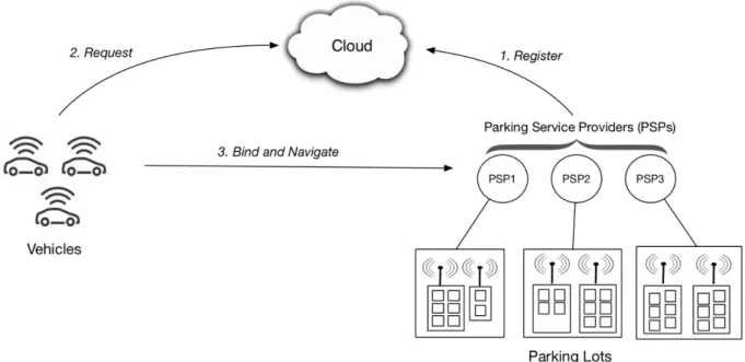
14 VTI rapport 1033A 2015, Mustafa et al. 2017, Nellore and Hanke 2016, Soomro et al. 2018). The streams of data that literally "senses the city" is increasingly driving open cloud-services to stimulate technology and business innovations. Smart-parking service providers are potential beneficiaries of this evolution, particularly with the expected progression towards connected and driverless vehicles. Figure 1 illustrates this.
This report presents a research project that utilizes data streams from parking lot gateways and traffic junction smart poles for development of a SmartPark algorithm. The algorithm is based on multi-criterion optimization that minimizes the journey duration to the selected parking lot, while
maximizing the chances to find an available spot there. The project was financed by Vinnova (grant number 2017-03028) and coordinated by VTI. Other partners in the project were University of Skövde, Stockholm City, Stockholm Parking and Kista Science City. This project consortium brought the expertise, knowledge and insight to the problem through a service provider, a parking company, a city and research organizations.
In the following chapters, first the SmartPark algorithm is described, which is followed by the
achieved results and evaluation of SmartPark algorithm in Kista district in Stockholm. Metrics used in the evaluation are time to arrive to the parking lot and the success/failure rate to find an available parking spot. Furthermore, the algorithm performance is demonstrated in a traffic simulation tool. The conclusions are provided in the last chapter.
VTI rapport 1033A 15
2.
SmartPark algorithm
The main problem addressed in this report is how to choose the best parking lot in a given parking area. This problem is subject to a range of criteria that may include user, municipality and parking-operator preferences. Users may have some preferences with respect to walking distance to
destination. Municipalities prefer to spread the traffic to reduce congestion in the urban core. Parking-operators seek to maximize parking lots utilization in order to increase the revenue on real-estate investments. To solve such a problem, an optimization algorithm based on a multicriteria decision-making process can be used.
Parking lot availability and traffic situations fluctuate across different seasonal periods, raising the need for a data approach to the parking selection problem that learns from past historical seasonal data to predict current parking and traffic-dynamics. Combination of data streams from parking lot
gateways and traffic junction smart poles provide the historical grounds to engage into predictive analytics to forecast traffic and parking dynamics that tune decision making processes (Akbar et al. 2017). In the following sections, short descriptions of multicriteria decision making and predictive analytics are provided.
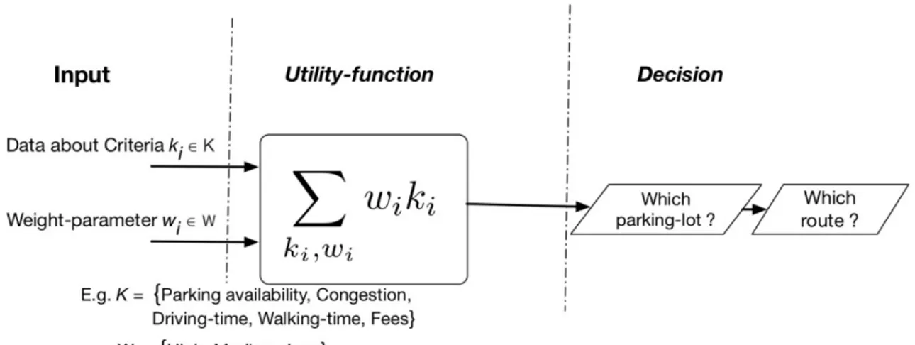
2.1. Multicriteria decision-making
A multicriteria decision-making algorithm maximizes a utility function involving different weighted criteria. In the SmartPark algorithm, these criteria can be set by the stakeholders, namely, drivers, parking operators and municipalities. Figure 2 illustrates such a combined optimization processing involving data sources from stakeholders as input.
Figure 2. Utility function involving different weighted criteria, set by the stakeholders.
2.2. Predictive analytics
In predictive analytics, techniques from data mining, predictive modelling and machine learning aew used to make predictions about future outcomes based on historical data. There are two mainstream bodies of literature with respect to representation of state variables of interest for predictive analysis: continuous and discrete models. The difference is in the number of state variable instances or
measurements that need to be collected or represented to perform the predictive analysis. Continuous measurements enable state variables to take any value on a number line, whereas discrete
measurements are confined to integer instances. Since predictive analysis is often probabilistic, this distinction results in different distributions.
Both continuous and discrete models have been used in the literature to address parking related issues. Examples of continuous models are queuing theory approaches (Caliskan et al. 2007, Tilahun &
16 VTI rapport 1033A Serugendo 2017) and machine learning approaches (Zheng et al. 2015, Shin et al. 2018, Hog & Jensen 2018), including deep learning (Shoeibi & Shoeibi 2019, Karakaya & Akinci 108). Discrete
approaches to the parking selection problem, like the suggested algorithm in this report, have also been quite extensively investigated, where quantification of uncertainty over future parking lot states have been addressed as well. Earlier studies focused on the parking type selection issues such as off-street vs. on-off-street parking with respect to pricing dynamics (Guan et al. 2005, Bagloee and Asadi 2012). Subsequent research combines travel experience and parking issues, such as park-and-ride optimization practices (Zhiyuan & Meng 2012, Prokop et al. 2016). Most recent research combines navigation and parking information to alleviate congestion issues associated with the cruising process towards a designated parking lot (Adewumi et al. 2014, Rybarsch et al. 2017, Liu et al. 2017, Rahman et al. 2018). The research project presented in this report is positioned within this last group and investigate decision making approaches for parking selection, including the routing process.
Particularly, the project addresses deficiencies in existing approaches that do not aggregate efficiently the various intervening characteristics to the parking selection problem. These factors include the degree of traffic congestion while navigating to the predicted parking facility. The utility of a chosen parking lot is based on a judicious balance between traffic congestion and parking lot availability. The project presents an original discrete stochastic approach to optimize this utility.
2.3. Algorithm assumptions
The parking lot selection algorithm proposed in this report involves a vehicle routing approach that maximizes the utility of the selected parking lot considering a multicriteria decision making process. To achieve this, a few assumptions on the available data are made.
It is assumed that the rate of entering and departing vehicles at a parking lot are known at any time, as well as the parking lot occupancy. Such historical data could be supplied by contemporary parking lot operators or future parking service providers seeking to leverage their services quality and increase the utilization rate of owned parking lots.
The proposed algorithm operates within the boundaries of the parking area, which is as an arbitrary area chosen to contain the desired destination and potentially interesting parking lots. The algorithm utilizes all parking lots in the parking area as part of the solution domain. It is also assumed that a vehicle’s GPS location is known when entering the parking area. This allows the proposed algorithm to be triggered and use the vehicle’s entry point as a navigation startup to any selected parking lot. Alternatively, motorists may specify the desired entry point and estimated time into the parking area offline, to trigger the algorithm ahead of time.
Additionally, it is assumed that smart poles are available at each junction of the parking area, recording traffic patterns. This real-time data can contribute to reducing congestion and carbon emission in the urban core, as influenced by the proposed SmartPark algorithm.
2.4. Parking area representation
To solve the parking search problem, the parking area is represented as a directed graph, where nodes represent junctions and edges represent road lanes. Each junction is linked to other junctions or parking lots by a single or a double lane road. Each smart pole collects congestion data via traffic sensors, while parking lots accessed via dedicated junctions are equipped with sensors detecting and reporting entrances, departures and parking occupancy, see Figure 3. Each smart component of the parking area is managed by an autonomous agent.
VTI rapport 1033A 17
Figure 3. Parking area representation.
2.5. Vehicle routing
The goal of the search process is to locate a parking junction and then to compute the expected arrival time, considering the traffic congestion from a given entry point. The search is carried out along two processes. A forward search process starts from the entry point node, which scouts the parking area for an available parking lot. When found, the predicted availability of the corresponding parking is
calculated, considering the estimated arrival time. A backtracking process carries back the availability rate and congestion attributes to the entry node. While doing so, the utility of the parking lot is re-evaluated at each junction point and the maximum utility is relayed back to predecessor node, until it reaches back the vehicle at the entry point node.
Figure 4 provides an example of the above processes, where vehicles are routed to designated parking lots upon entering a congested parking area. A simplified congestion model that is consistent with the conventional traffic flow theory is adopted (Wardrop 1952). Each road edge between two junctions is directed and has a capacity of vehicles on the edge lanes. Entering vehicles onto an edge i of the road are captured by the junctions’ smart pole to determine the density di of the traffic, formulated as di =
N/Ki ,where N is number of vehicles on the road edge, and Ki is the maximum number of vehicles that
could be accommodated on that edge, expressed as percentages in the graph-based representation of the parking area in Figure 4.
18 VTI rapport 1033A This local information is worked out in real time by smart poles and communicated to the search process triggered by a vehicle entering a parking area to figure out a global congestion rate. The
𝑑𝑑 congestion model is generalized over the parking area with a global value 𝐶𝐶 = ∑𝑗𝑗 𝑖𝑖�
𝑖𝑖=1 𝐿𝐿, where L is the total number of road edges in the parking area. This global congestion rate estimate is used later by the parking state prediction algorithm to infer parking states, considering expected arrival time. Given a parking lot, the path-finding problem consists of finding the best path to that lot from a given entry point, in terms of driving time, in order to derive the expected arrival time to the parking lot. The search space consists of a graph where the root node represents the entry point, and the nodes at the next level represent all junctions that could be visited directly from the entry point, whereas the nodes at the following level represent all junctions that could be visited from outgoing junctions in the previous level, etc. In this tree-like view of the graph traversal, the maximum depth is the number of junctions, and the candidate parking junction within this depth. The use of Dijkstra’s algorithm (Dijkstra 1959) guarantees to find an optimal path which minimizes travelling time to a given parking lot. It should be noted that multiple vehicles coming through the same entry point and heading for the same parking lot, may not follow the same "shortest" path. This is because a query to smart poles at junctions enables the algorithm to work out a new path for each parking request, considering the new values of congestion rates returned by smart poles, resulting in a new shortest path.
2.6. Historical data representation and state modeling
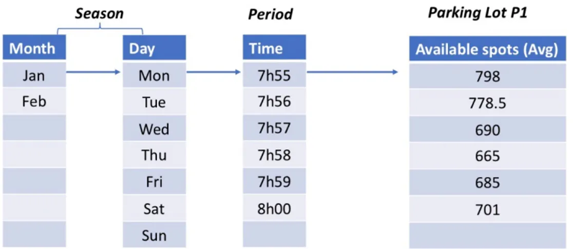
Using historical parking occupancy data from parking lot sensors, a categorization based on seasonal periods across several instances of the historical data can be obtained. This categorization can be used to match current parking considerations with similar historical situations for a given parking lot. The seasonal classification aims at capturing similar periods, which are chosen to be small enough to reduce variations in parking dynamics. This data representation is meant to model the randomly changing parking’s available spots whereby a future state depends only on the current state and does not depend on any event that may have occurred before it. This property is called the Markov property whereby a stochastic model based on a Markov process can be used to describe parking dynamics. It is the availability of a certain parking lot that is the variable of interest here. Figure 5 illustrates an example of such parking data. The parking availability variable is averaged over multiple historical one-minute period observations across similar seasons. The time period is chosen sufficiently small to assume discrete state changes of a parking lot modelled over a time span of 5 minutes during which arrival and departure rates are assumed fixed. The next 5-minute cycle uses a similar discrete state change model, but with different arrival and departure rate values.
VTI rapport 1033A 19 The small 5-minute interval assumes a stationary arrival/departure rate Poisson process with a fixed mean value of entering and departing vehicles to/from parking lot Pi over a single observation period.
The Poisson distribution is used in the simulation to represent the arrival process into periods, parking states are derived for each parking lot. A state represents the parking availability range. Following Kendal’s notation (Kendall 1953), the classic Markov-chain model is used to predict the future availability state of a parking lot Si, given that the current state is Sj, denoted as 𝑃𝑃(𝑆𝑆𝑖𝑖�𝑆𝑆𝑗𝑗). A fixed
arrival/departure rate of vehicles is used for each parking lot Pi to describe its queueing model over a
5-minute observation period. Arrival/departure rate variation is handled across observation windows but considered fixed within each observation window, which is deliberately chosen small enough to justify this assumption. Each state corresponds to an availability rate range. The proposed model employs 6 states, ranging from the highly occupied state S0 to the highly available state S5 of a parking
lot. A sample is shown in Figure 6 for a parking lot with capacity Ci = 1000, where an occurrence
frequency matrix is derived for the currently 5-minute observed period from the historical data. A normalized transition matrix is also depicted in Figure 6, which describes the parking dynamic availability patterns within the observed period in terms of probabilistic weights.
The Markov model provides an inference approach through connecting the dependencies of current period information, i.e. parking lot availability, with historical information of parking availabilities in similar periods. For each parking lot, a current observation time window, an arrival rate, a departure rate and a state transition matrix are established. Under short periods of time that fit within a single observation window size (i.e. 5 minutes), a single state transition matrix holds the parking dynamics information. However, if the calculated trip time from the entry point of the parking area to the targeted parking lot exceeds the duration of a single observation window, the corresponding transition matrices for each time window of the calculated time period are multiplied to estimate the state of the targeted parking lot at time of arrival.
The parking selection process is triggered once a vehicle enters the parking area from a given entry point. The geographical map of the parking area is an input to the parking selection algorithm as well as the list of parking lots and their related attributes, such as capacity, current availability and
transition matrices. The traffic data returned by smart pole sensors within the parking area is conveyed to the algorithm in the form of consecutive congestion rates. Using these inputs, the parking algorithm finds the parking lot with the best chance of having a vacant spot once the vehicle reaches it. The best route to reach each parking lot is searched considering the entry point and the list of current congestion rates for the road edges. More information about the SmartPark algorithm and its implementation can be found in (Atif et al. 2019).
Figure 6. Markov state model.
Occurrence frequency Transition matrix Availability States
20 VTI rapport 1033A
3.
Evaluation of the SmartPark algorithm
To evaluate the developed SmartPark algorithm, a geographical area in Stockholm is selected as the test parking area. The parking model is parameterized based on sample parking data from Stockholm provided by Stockholm Parking. However, due to limitations of the available data, it is complemented with artificially crafted data.
3.1. Geographical area selection
Considering the project partners’ interest and needs, the selection of geographical area for the project is limited to Stockholm. The minimum requirement for this area is that it should allow for enough degrees of freedom to prove the effectiveness of the developed algorithm. At the same time there is also a need to limit the area to get a tractable problem. The selection criteria can be summarized as below:
• A parking area with a geographical orientation that have number of available parking lots. Street parking will not be considered in the optimization problem.
• A set of routes leading to the parking lots. This means that it should be possible to guide a car to a specific parking lot and the choices should ideally have different implications on the output (e.g. travel time, congestions, emissions, etc.)
• The areas should be large enough to include parking lots and route possibilities with the above-mentioned properties. However, the areas need to be well limited in size. Too large areas can overcomplicate the problem at hand without gaining or adding to the generality of the solutions.
• It should be possible to parameterize the traffic and parking models from relevant data.
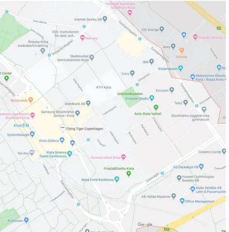
VTI rapport 1033A 21 Considering the above criteria, part of the Kista district in Stockholm is chosen as the geographical area for simulation and demonstration of the developed algorithm. Kista is a busy hub with variety of business and shopping stores, as well as a booming science and innovation center. A map of the selected area is provided in Figure 7.
3.2. Simulation set-up
A simplified version of the selected parking area is used in the simulations with parking lots randomly situated at junctions. Parking data provided by Stockholm Parking from the Kista district and other parts of Stockholm is used as a base in the simulations and complemented with artificially crafted data. A maximum capacity of 200 parking spots is considered for each parking lot, with arrival and departure rates of 10 and 5 vehicles per minute. The initial availability of the parking lots is randomly generated following a uniform distribution, with an upper bound of 90%. A parking lot is deemed full if its occupancy exceeds 80%. A varying degree of traffic density is injected into the simulation to evaluate the performance of the proposed SmartPark algorithm under different traffic considerations. In addition to the SmartPark algorithm, a baseline parking search behavior, referred to as BlindPark algorithm, is also simulated and compared with the SmartPark algorithm. In the BlindPark algorithm, the vehicle is driven to the nearest parking lot, in the hope of reducing driving time. However, the parking lot may turn out to be full, and thus the vehicle path is augmented with a new segment leading to the next nearest parking lot, starting from the current vehicle location. This procedure continues until a parking lot with available spot is found.
The SmartPark and BlindPark algorithms are simulated and compared with varying number of parking lots in the parking area, as well as under varying congestion rate situations. The vehicle entry point to the parking area is fixed to create a controlled experimental environment. This allows study of the scalability of the candidate algorithms when parking resources increase, and the ability to adjust to varying traffic considerations.
Two performance metrics are used in the proposed experimental setup: the failure rate and arrival time. The failure rate reflects the blocking probability, which is the risk that a vehicle finds a designated parking lot, suggested by the candidate algorithm, full. The parking dynamics model, described earlier, is used to determine the available spots in the designated lot. Subsequently, the failure rate for each parking lot is obtained from the availability rate, as follows:
𝐹𝐹𝐹𝐹𝐹𝐹𝐹𝐹𝐹𝐹𝐹𝐹𝐹𝐹𝐹𝐹𝐹𝐹𝐹𝐹𝐹𝐹 = 1 − 𝐴𝐴𝐴𝐴𝐹𝐹𝐹𝐹𝐹𝐹𝐹𝐹𝐴𝐴𝐹𝐹𝐹𝐹𝐹𝐹𝐹𝐹𝐴𝐴𝐹𝐹𝐹𝐹𝐹𝐹𝐹𝐹 = 1 −𝑉𝑉𝐹𝐹𝑉𝑉𝐹𝐹𝑛𝑛𝐹𝐹𝑆𝑆𝑛𝑛𝑛𝑛𝐹𝐹𝑛𝑛𝑇𝑇𝑛𝑛𝐹𝐹𝐹𝐹𝐹𝐹𝑆𝑆𝑛𝑛𝑛𝑛𝐹𝐹𝑛𝑛
VacantSpots is retrieved from the corresponding state at which the parking lot is found upon arrival of
the vehicle controlled by the candidate algorithms, and TotalSpots is the parking lot capacity.
The arrival time metric measures the time duration that a vehicle, controlled by candidate algorithms, spends within the parking area from its entry until it reaches a parking lot with an available spot. Vehicles may pass through full parking lots until a successful one is found. A clock is maintained throughout the simulation to record vehicles’ arrival time to a parking lot whose availability rate falls below the defined threshold (i.e. 80%).
3.3. Evaluation results
In the first experiment, the scalability performance of the candidate algorithms to decrease the failure rate when taking advantage of increasing instances of parking lots in the parking area, is investigated. The injected traffic in this experiment is fixed at a high rate of 0.8, while the number of parking lots range from 1 to 9. Figure 8 shows the average result of 20 simulation runs, with error bars showing the deviation of the sample means. The figure shows that the SmartPark algorithm takes better advantage of the available parking lots in the parking area, scaling down gracefully the failure rate as more
22 VTI rapport 1033A parking lots are provided. The SmartPark algorithm outperforms the greedy BlindPark, which routes vehicles naively to the nearest parking lots, while facing consistently higher failure probabilities. It should be noted that in this experiment, only the first parking lot chosen by the candidate algorithms is used in the evaluation. However, each algorithm continues to guide the vehicle to other parking lots until an available spot is found. The arrival time to a designated parking lot with available spot is discussed and compared afterward.
Figure 8. Parking scalability performance with congestion rate fixed at 0.8.
VTI rapport 1033A 23 In the second experiment, SmartPark and BlindPark failure rates are compared in simulations with a varying degree of congestion rates encountered while driving in the parking area. Hence, the
performance metric is still the probability of finding an available spot in the designated parking lot when the vehicle controlled by the candidate algorithms reaches it. In this experiment, the number of parking lots is fixed to 8. Figure 9 shows the average result of 20 simulation runs, with error bars showing the deviation of the sample means. The figure shows that SmartPark is not sensitive to congestion fluctuations due to its ability to use real-time traffic data from smart poles across the parking area. BlindPark algorithm on the other hand, is unaware of the traffic situation, driving cars to the nearest parking lot, which may be highly occupied.
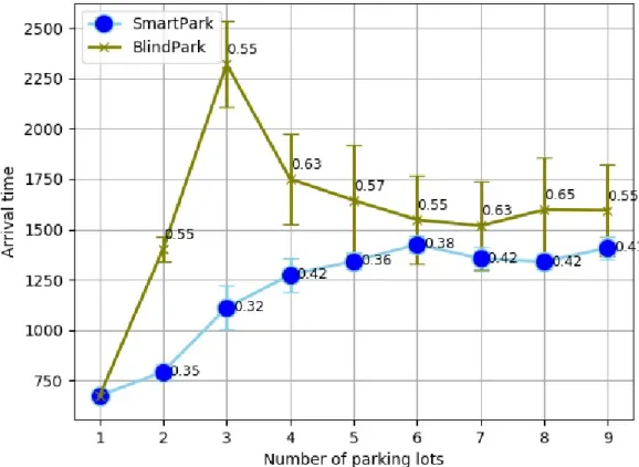
Next, the above experiments are repeated and the arrival time to a designated parking lot with available spot are compared. Thus, in this case the simulation continues to run until an available spot is found by the candidate algorithms. Figure 10 illustrates that for the experiment with varying numbers of parking lots and fixed congestion rate of 0.8, the SmartPark algorithm has a lower arrival time for all cases, compared with the BlindPark. The figure shows arrival times in seconds since entering the parking area, while the dots in the curves show the failure rate of the parking lot, once the vehicle arrives there. SmartPark consistently leads vehicles to a parking lot with lower failure rates, yet those vehicles arrive earlier than the ones led by the BlindPark algorithm. With only one parking lot in the parking area, both algorithms have no choice but to lead vehicles to the same parking lot, but the arrival time gap expands as more parking lots are made available. Eventually, as parking resources increase, chances to blindly encounter an available parking lot increase too, allowing BlindPark to achieve lower arrival times, after a peak of about 20 minutes delay difference compared to SmartPark. The arrival times gap narrows as further parking lots are provided, yet SmartPark always keeps a lower failure rate. SmartPark cars consistently arrive earlier to the designated lot, yet with a lower failure rate (at most 0.42). The figure shows the average result of 20 runs, with error bars showing the deviation of the sample means. BlindPark error bars are much wider than SmartPark ones, which indicates that SmartPark is more predictable, ensuring the arrival time remains within a narrower interval.
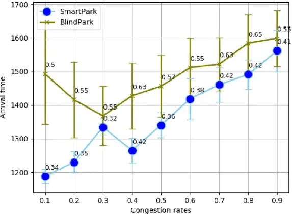
24 VTI rapport 1033A In the other experiment, the influence of congestion rates on the arrival time is studied. Figure 11 shows that the arrival times generally increase within an increasingly congested parking area. Traffic congestion data is captured by real-time sensors in junction smart poles and are used by the SmartPark search algorithm to choose an optimal parking lot. SmartPark’s integration of traffic data trades routing and parking allocation problems in a way that vehicles reach a highly promising parking lot with failure rates ranging from 0.34 to 0.41. However, BlindPark vehicles arrive later to parking lots with failure rates ranging from 0.5 to 0.65. While parking availability chances are always in the advantage of SmartPark-led vehicles, the arrival time gap narrows further with congestion rates, making it difficult for both algorithms to move vehicles at a higher speed as the parking area becomes packed.
Figure 11. Arrival time to a parking lot with available spot, number of parking lots is fixed at 8.
3.4. Demonstration in SUMO
The SmartPark algorithm performance is also demonstrated in a traffic simulation tool called SUMO, which stands for Simulation of Urban Mobility. SUMO is a free and open-source traffic simulation package, in which each vehicle is defined explicitly and has a defined route through the network. A type can be assigned to each vehicle to describe the vehicle’s physical properties and the variables of the behavioral sub-models (Behrisch, et.al. 2011). The default behavioral model in SUMO is a modification of the model defined by Krauß (1998), which lets vehicles drive as fast as possible while maintaining perfect safety.
To demonstrate the SmartPark algorithm performance versus BlindPark, the selected part of the Kista district is modelled in SUMO. To create the parking area, the road network data is imported to SUMO from OpenStreetMap (https://www.openstreetmap.org/) and simplified. Eight parking lots are
considered at random junctions in the area, see Figure 12. Random traffic is generated in the road network. Two vehicles, one controlled by the SmartPark algorithm and the other one by the BlindPark, are added to the traffic simulation at the same entry point. The SUMO demonstration confirms the previously described simulation results and a significant difference is demonstrated in the time it takes to find a parking lot with an available spot with each algorithm.
VTI rapport 1033A 25
26 VTI rapport 1033A
4.
Conclusions
A SmartPark algorithm for guiding vehicles to the best parking lot in a parking area is developed and evaluated in this report. The suggested algorithm takes advantages of historical parking occupancy data, as well as the current state of a parking lot and traffic congestion in the area, provided by the smart and connected infrastructure. The SmartPark algorithm exploits the data stream from the connected infrastructure to choose a parking lot that minimizes the driving duration while maximizing the chances to find an available parking spot.
To evaluate the developed SmartPark algorithm, a geographical area in Stockholm, part of the Kista district, is selected as the test parking area. The parking model is parameterized based on sample parking data from Stockholm provided by Stockholm Parking, which is complemented with artificially crafted data. In addition, a baseline parking search behavior, referred to as the BlindPark algorithm, is also simulated and compared with the SmartPark algorithm. In the BlindPark algorithm, the vehicle is driven to the nearest parking lot, in the hope of reducing driving time.
The SmartPark and BlindPark algorithms are simulated and compared with a varying number of parking lots, as well as under varying traffic situations. SmartPark always keeps a lower failure rate compared with BlindPark. Further, the probability to find available spots in a lot chosen by SmartPark is always higher than BlindPark. In other words, SmartPark cars consistently arrive earlier to the designated lot, yet with a lower failure rate. The evaluation results show an increased scalability of the SmartPark algorithm when further parking resources are made available.
The SmartPark algorithm performance versus BlindPark is also demonstrated in a traffic simulation tool called SUMO (Simulation of Urban Mobility). The SUMO demonstration confirms the simulation results and a significant difference is demonstrated in the time it takes to find a parking lot with an available spot with each algorithm.
The outcomes of this project illustrate how recent advances in data sharing and aggregation among connected vehicles, and in sensor developments embedded within vehicles as well as parking infrastructures, hold a viable solution to the parking seeking problem.
VTI rapport 1033A 27
References
Adewumi, A., Joel, L. and Sawyerr, B. (2014). Campus parking space allocation distribution using pattern search and particle swarm pattern search algorithms. In: Joint 7th International Conference on
Soft Computing and Intelligent Systems and 15th International Symposium on Advanced Intelligent Systems. pp. 196–203.
Akbar, A., Khan A., Carrez, F. and Moessner, K. (2017). Predictive analytics for complex IoT data streams. IEEE Internet of Things Journal, 4(5), pp.1571–1582.
Atif, Y., Kharrazi, S., Jianguo, J. and Andler, S. (2020). Internet of Things data analytics for parking availability prediction and guidance. Transactions on Emerging Telecommunications Technologies. Bagloee S. and Asadi, M. (2012). Methodology for parking modeling and pricing in traffic impact studies. Transportation Research Record.
Behrisch, M., Bieker, L., Erdmann, J. and Krajzewicz, D. (2011). SUMO – Simulation of Urban Mobility. In: The third international conference on advances in system simulation. Barcelona.
Caliskan, M., Barthels, A., Scheuermann, B. and Mauve, M. (2007). Predicting parking lot occupancy in vehicular ad hoc networks. In: IEEE 65th Vehicular Technology Conference. pp. 277–281.
Dijkstra. E. W. (1959). A Note on Two Problems in Connexion with Graphs. Numerische
Mathematik, 1, pp. 269–271.
Gantelet E. and Lefauconnier A. (2006). The time looking for a parking space: strategies, associated nuisances and stakes of parking management in France. In: European Transport Conference. Strasbourg.
Guan, H., Sun, X., Liu, X. and Liu, L. (2005). Modeling parking behavior of better control and pricing: A case study from one of the busiest retail shopping areas in Beijing, China. In: The 84th
Annual Meeting of the Transportation Research Board, Washington, D.C.
Idris, M., Leng, Y., Tamil, E., Noor, N. and Razak, Z. (2009). Саг park system: a review of smart parking system and its technology. Information Technology Journal, 8 (2), pp. 101-113.
Jensen, T. (2018). Parking space verification. In: The 12th International Joint Conference on
Computer Vision, Imaging and Computer Graphics Theory and Applications. pp. 311–318.
Karakaya M. and Akinci, F. (2018). Parking space occupancy detection using deep learning methods. In: The 26th Signal Processing and Communications Applications Conference. pp. 1–4.
Kendall, D. G. (1953). Stochastic processes occurring in the theory of queues and their analysis by the method of imbedded Markov chains. Annals of Mathematical Statistics, 24, pp. 338-354.
Krauß, S. (1998). Microscopic modeling of traffic flow: Investigation of collision free vehicle dynamics. PhD. University of Cologne.
Kurogo, H., Takada, K. and Akiyama, H. (1995). Concept of a parking guidance system and its effects in the Shinjuku area-configuration, performance, and future improvement of system. In: Pacific Rim
TransTech Conference. 1995 Vehicle Navigation and Information Systems Conference Proceedings. 6th International VNIS. A Ride into the Future. Seattle, WA, pp. 67-74.
28 VTI rapport 1033A Liu, R., Yang, Y., Kwak, D., Hang, D., Iftode, L. and Nath, B. (2017). Your search path tells others where to park. The ACM on Interactive, Mobile, Wearable and Ubiquitous Technologies, 1(3), pp. 1– 27.
Liu Z. and Meng, Q. (2012). Bus-based park-and-ride system: a stochastic model on multimodal network with congestion pricing schemes. International Journal of Systems Science, 45(5), pp. 994– 1006.
Mustafa, A., Abubakr, O. and Derbala A. (2017). Evaluation of a traffic-aware smart highway lighting system. EAI Endorsed Transactions on Future Internet, 4(12).
Nellore K. and Hancke, G. (2016). A survey on urban traffic management system using wireless sensor networks. Sensors, 16(2).
Prokop, B.,Owsinski, J. Sep, K. and Sapiecha, P. (2016). Solving the k-centre problem as a method for supporting the park and ride facilities location decision. In: Federated Conference on Computer
Science and Information Systems. pp. 1223–1228.
Rehman, M., Shah, M., Khan, M. and Ahmad, S. (2018). A vanet based smart car parking system to minimize searching time, fuel consumption and co2 emission. In: The 24th International Conference
on Automation and Computing. pp. 1–6.
Rhodes, C., Blewitt, W., Sharp, C., Ushaw, G. and Morgan, G. (2014). Smart Routing: A Novel Application of Collaborative Path-Finding to Smart Parking Systems. In: IEEE 16th Conference on
Business Informatics. Geneva, pp. 119-126.
Rybarsch, M., Aschermann, M., Bock, F., Goralzik, A., Köster, F., Ringhand, M. and Trifunovic, F. (2017). Cooperative parking search: Reducing travel time by information exchange among searching vehicles. In: IEEE 20th International Conference on Intelligent Transportation Systems. pp. 1-6.
Sanguesa, J., Barrachina, J., Fogue, M., Garrido, P., Martinez, F., Cano, J., Calafate, C. and Manzoni, P. (2015). Sensing traffic density combining v2v and v2i wireless communications. Sensors, 15(12), pp. 31794–31810.
Shin, J. Jun, H. and Kim, J. (2018). Dynamic control of intelligent parking guidance using neural network predictive control. Computers & Industrial Engineering, 120, pp.15–30.
Shoeibi, N. and Shoeibi, N. (2019). Future of smart parking: Automated valet parking using deep q-learning. In: Distributed Computing and Artificial Intelligence, 16th International Conference. pp. 177– 182.
Shoup D. (2007). Cruising for Parking. ACCESS, 30, pp.16-22.
Soomro, S., Miraz, M., Prasanth, A. and Abdullah, M. (2018). Artificial intelligence enabled IoT: Traffic congestion reduction in smart cities. In: Smart Cities Symposium.
Tilahun S. and Serugendo G. (2017). Cooperative Multiagent System for Parking Availability Prediction Based on Time Varying Dynamic Markov Chains. Journal of Advanced Transportation. Wardrop, J. (1952). Some theoretical aspects of road traffic research. Proceedings of The Institution of
VTI rapport 1033A 29 Yoo S. et al. (2008). PGS: Parking Guidance System based on wireless sensor network. In: The third
International Symposium on Wireless Pervasive Computing. Santorini, pp. 218-222.
Zheng, Y., Rajasegarar, S. and Leckie, C. (2015). Parking availability prediction for sensor-enabled car parks in smart cities. In: IEEE Tenth International Conference on Intelligent Sensors, Sensor
Swedish National Road and Transport Research Institute • www.vti.se • vti@vti.se • +46 (0)13–20 40 00 ABOUT VTI
T
he Swedish National Road and Transport Research Institute (VTI), is an independent and internationally prominent research institute in the transport sector. Our principal task is to conduct research and develop-ment related to infrastructure, traffic and transport. We are dedicated to the con-tinuous development of knowledge pertaining to the transport sector, and in this way contribute actively to the attainment of the goals of Swedish transport policy. Our operations cover all modes of transport, and the subjects of pavement technology, infrastructure maintenance, vehicle technology, traffic safety, traffic analysis, users of the transport system, the environment, the planning and deci-sion making processes, transport economics and transport systems. Knowledge that the institute develops provides a basis for decisions made by stakeholders in the transport sector. In many cases our findings lead to direct applications in both national and international transport policies.VTI conducts commissioned research in an interdisciplinary organisation. Employ-ees also conduct investigations, provide counseling and perform various services in measurement and testing. The institute has a wide range of advanced research equipment and world-class driving simulators. There are also laboratories for road material testing and crash safety testing.
In Sweden VTI cooperates with universities engaged in related research and education. We also participate continuously in international research projects, networks and alliances.
The Institute is an assignment-based authority under the Ministry of Infrastruc- ture. The Institute holds the quality management systems certificate ISO 9001 and the environmental management systems certificate ISO 14001. Certain test methods used in our labs for crash safety testing and road materials testing are also certified by Swedac.