Scientific Press International Limited
Water Resources Projects: Large Storage Dams
Mukhalad Abdullah1, Nadhir Al-Ansari2 and Jan Laue3Abstract
Several dams were built on Tigris, Euphrates, and Tigris tributaries in Iraq. The construction of dams had been done in the second half of 20th century. Of the most critical issues confronting the large storage dams in Iraq are the liquefactions in Mosul Dam foundations, land sliding and earthquake effects in Darbandikhan Dam, and the essential maintenance and rehabilitation requirements almost for all the dams. Absolutely, large storage dams made Iraq surviving from thirst in several occasions. Unfortunately, after 2003, the attention or will are not exist pertaining the building of new or partially built large dams.
Keywords: Mosul Dam, Dokan Dam, Darbandikhan Dam, Adhaim Dam, Hemrin Dam, Haditha Dam, Iraq Dams.
1 Private Engineer, Baghdad, Iraq.
2 Lulea University of Technology, Lulea 971 87, Sweden. 3 Lulea University of Technology, Lulea 971 87, Sweden.
Article Info: Received: October 20, 2019. Revised: November 11, 2019.
1. Introduction
Large storage dams were not a major interest for either Consultants or Directorate General of Irrigation in Iraq in the 1st half of 20th century. They were mainly interested at the time about flood control, dykes construction and so on. Later, based on the will for agricultural expansion and rising the agricultural intensity to improve the food security and job opportunities, in addition to the adoption of Turkish side in the mid of 1930s the construction of reservoirs in the Southern-east Anatolia Project (GAP) For economic, political and security purposes. Hence, proposals were presented for the construction of dams, the early studies by Sir Coode Wilson & Partners Consultants and the subsequent study presented by Heigh Commission highlighted the importance of construction of dams such as Bekhme, Aski-Mosul, and Lesser Zab River and Diyala River dams.
These ideas and proposals did not receive realistic action until the commencing of Development Board, which had started implementing some dams and intensified the studies for other dams. Despite the passing of more than six decades since the opening of the first Iraqi dams, and the adoption of plans and allocating funds, but the political circumstances hindered the completion of major dams Bekhme, Makhoul, and Baghdadi. Although, there are urgent needs for these reservoirs, as they provide the quantity and quality of important water to meet the growing requirements for Iraq in the different consuming sectors. This paper will address the dams that have been completed and there are other dams partially implemented or planned and stalled for various reasons. The illustrated large storage dams in term of capacity are the dams that holding the large reservoirs, that have more than one billion cubic meters of capacity.
2. Mosul Dam
Mosul Dam is the most important and largest existing dam in Iraq, and the only dam on the Tigris River main stream in Iraq. Studies were initiated to for the dam by Development Board through the companies (Alexander Gibbs & Partners) and (Munsel Basford and Bafrey), they prepared a study and submitted a joint report in 1953 that included the proposal of two sites near the moonlight village north of Aski Mosul, the proposals included a storage dam with a capacity of 8.7 billion cubic meters, and elevation of 320m a.s.l. Then, the American company Harza was commissioned by Development Board to study the project and it presented the full report in 1960, Harza Company has indicated that the proposed previous sites are not appropriate geologically and proposed two new locations; the first has a capacity of 7.8 billion cubic meters at elevation of 320m a.s.l. and the second has a capacity of 13.5 billion cubic meters and elevation of 325m a.s.l.
At the early of Republican era, the Soviet Company Technopromexport submitted a new study in 1962 and a proposal for a new storage dam with a capacity of 7.7 billion cubic meters at elevation 312m a.s.l. Then, Imatran Voima Company was assigned to prepare a study for the proposed dam and it was presented in 1973, the report has been evaluated by Technopromexport and Board of Experts, they both
raised notes concerning the dam and the need to intensify geological investigations. Next, the dam construction proposal presented for Hochtief Company to do it in 1974, and after the company review, the agreement did not happen due to the foundations issue of the dam. The French company, Solseif, was later commissioned to conduct geological investigations and presented its findings in 1979. Finally, agreement was reached with the Swiss consultants to prepare the dam study, which was presented in 1979 [1,2].
What has been manifested about studies, where many parties had been involved with an approaching results highlights clearly the sensitivity of Mosul Dam foundations, which resulted that the consulting companies and decision makers to re-examine and study the dam site several times, they convened a final conclusion that the dam underneath has gypsum formations which made a threat to the safety of the dam proposal, the alternative between the site and another of what it takes less remedies, and it will not be possible to find a site far of this negative findings. A question may come to front about the aims of creating such a dam which includes this technical risk. In comparison with the benefits achieved by the dam, such as the expansion of agricultural lands, meeting the municipal requirements, and provisioning the strategic storage especially in the years 1999,2000, 2001, and 2018 which were associated drought seasons, and after three decades of operation of the dam. Hence, it can easily say that if Mosul Dam does not exist, the consequences are dire for the agricultural sector and even for municipal requirements.
The works of the dam began on 25/1/1981 and was completed and the operation started on 24/07/1986. Swiss consultants, who made the last study about the dam and Energoporjekt Company, were entrusted to supervise the implementation of the dam within the framework of what is known as the Mosul Dam Group (MODACOM), while the implementation awarded to German-Italian consortium called (GIMOD) [1].
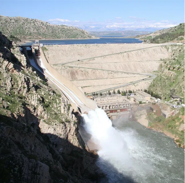
The dam project consists of the main dam with a length of 3600 m, it is and earth fill dam with a clay core. The tallest height of the dam is 100 m and the operational level is 330m a.s.l. The design storage is 11.11 billion cubic meters. The minimum operational level is 300m a.s.l., below a dead storage equals to 2.95 billion cubic meters, as the live storage is 8.16 billion cubic meters. The dam has a gated spillway on the left side; the spillway maximum discharge is 7400m3/s at the maximum flooding level of 338.5m a.sl. The length of the spillway is 1.013 meters and the width is 50 meters. The flow energy through Flip-bucket end of the spillway which directed the flow 25o of horizon, Figure 1 shows a general view of Mosul Dam [1, 2, 3].
The dam includes 4 power units of Francis turbines on the right side of the dam with a total capacity of 750 MW. On the right side also, there are 2 bottom outlets that ensure a minimum discharge of 330m3/s at the elevation of 300m a.sl. The dam also includes two diversion tunnels on the right side of the dam shoulder. The project includes a pumped storage hydropower station by storage and pumping, this station aims to meet the consumption during the peak of energy demand without wasting quantities of water. The water is stored in an artificial lake with a capacity of 11
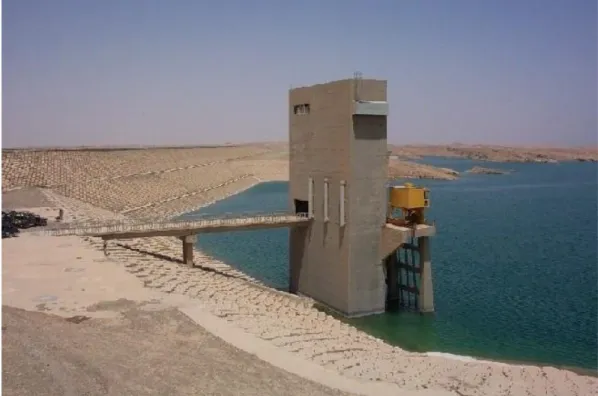
million cubic meters constructed above Taira Hill to the right of the dam, where this plant generates 200 megawatts. There is also within the body of the dam the outlet of the South Jazeera irrigation project, which has not been completed yet, and there is a proposed hydropower station in the outlet route [1, 2, 3].
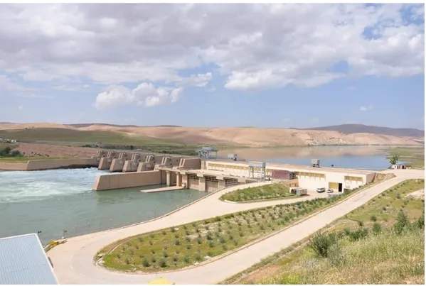
Figure 1: General view of Mosul Dam (Edited by Author). (Source:[4]) Mosul Dam is a giant project that includes a number of details, such as fuse-plug dam on the left side of the main dam, grouting tunnels, electric transformers, piezometers, as well as infrastructure for control, management, grouting and other services. Beneath the main dam, the grouting blanket had been implemented with 20 lines and depths of (25-10m). Further; the curtain grouting were implemented which consists 5 lines, three of them are vertical, and the two on both sides has inclination of 6o, the curtain grouting varies in depth and reaching up to 150m [5]. Downstream of the main dam and at a distance of 9km, the regulation dam was built on Tigris stream to control the high discharges from power plants and ensure a minimum discharge 330m3/s. This dam was implemented by Austrian company Allen Union. The length of the regulation dam is 381m and the height is 20m; it is an earth fill dam with storage capacity of 21 million cubic meters. The dam includes tunnels, bottom outlets, spillway and power station that have 4 units of Kaplan turbines with a capacity of 60M [1, 2, 3].
Figure 2: General view of the Regulation Dam, Mosul Dam project. (Source:[6]).
After the opening of Mosul Dam in 1986, the leaks began to appear from the downstream of the dam body at rates higher than the expected. Measurement data for sensors in the dam were periodically discussed with Board of Experts. As a result, they decided that the dam administration to continue the grouting during the service life of the dam. Several sinkholes appeared in the dam site, the first sinkhole occurred in 1986, this was followed by a group of sinkholes that occurred from 1992 to 1998, these sinkholes lying nearly on an axis that parallel to main dam axis. There was also a spring observed in the river stream near the right bank. In February 2003, a large sinkhole occurred suddenly in the left bank near the curtain and the main dam. Also, another one occurred in 2005. Further sinkholes and cavities discovered at the bed of the lake itself and in the surrounding areas. As a result, a Board of Experts had recommended to limit the storage at elevation of 319m a.s.l.[1, 5, 7, 8]. Figure 3 shows the locations of sinkholes on the right bank downstream of Mosul Dam.
Figure 3: Locations of sinkholes on the right bank downstream Mosul Dam. (Source:[5]).
The justification of the unexpected consequences in Mosul Dam foundations, which appeared after implementation were attributed to the lack of investigation and enough understanding of formations of gypsum beneath the dam. The estimated depth of gypsum formations was 100m, and then it is appeared that the depths of these formations are up to 300m during the implementation. It was possible at the time to overcome this issue by constructing diaphragm wall in the foundation of the dam at the initial stages of implementation, this technique was available at the time, but requires an extension of the implementation period, which had no objections about by the Iraqi representatives[1, 8].
A book entitled (Mosul Dam: Full Story) was written by a group of experts in dams and geology in Iraq who participated as representatives from the Iraqi side in the study and implementation of Mosul Dam. The book included details of the foundations of Mosul dam. A conclusion quoted from this book reflects the point of view by most of the dam engineers and geologists experienced in Iraq regarding the issue of Mosul Dam foundations, the conclusion is the following:
have realized the existence of gypsum rocks in the foundations. They recommended that the grouting treatments should be done to avoid the dangers of gypsum liquefaction, but we now know that all of them, despite the intensive geological investigations that had been made, they did not correctly assess the extent of the scattering of gypsum rocks and the enormous extent of cavities and liquefaction in those foundations. It can be also said that they all did not have the knowledge and experience enough in the right treatment of gypsum rocks"[1].
The Ministry of Water Resources after 2003 adopted the option of implementing a middle wall diaphragm, but another alternative adopted later, which is to continue the grouting of the base. After the chaos in 2014 and the occupation of Mosul Dam, the foundations issue spotlighted with an exceptional coverage by global media. This has been resulted the signing of a rehabilitation contract with the Italian company Trevi for the work of grouting, training, and maintenance of the dam. The company has continued to carry out the traditional grouting works with the supply of the dam project with modern sensors and rigs; they finalize the works on June 2019 [2, 4]. A number of international organizations have also carried out simulation scenarios of the dam break, in addition to the studies prepared by the consultants who studied the dam at the beginning. Of these studies, it was found that the analysis of the default break of the worst scenario at the storage level 330m a.s.l. will cause wave height of 25m, where the wave reaches the city of Mosul in 1 hour and 40 minutes, and reach the city of Baghdad in 3.5 days. The flood wave has effect on 6 million people, 2 million people with flooded areas to a depth of 2m and 270 thousand people with flooded areas to depths of more than 10m. The most affected city is Mosul [9]. Figures 4 and 5 show the inundation of Mosul and Baghdad cities for the calculated Mosul Dam break scenarios when storage at elevation of 330m a.s.l.
It is wise to mention the contribution by one of the researchers who made a bathymetric survey for Mosul Dam Reservoir in 2011. The results showed that the live storage of the reservoir had decreased from 8.16 to 7.597 billion cubic meters; the dead storage also had decreased from 2.95 to 2.37 billion cubic meters. The total storage became 9.967 billion cubic meters. The annual sediment income was 45.73 million cubic meters. The survey showed that the sediments were accumulated at the beginning of the reservoir, which is very natural. The interesting finding of this study is the discovery of cavities at the bed of the reservoir; in sizes comparatively larger what had been founded downstream of the dam. Figure 6 shows the results of the bathymetric survey of the Mosul Dam reservoir and its comparison with the topography of the lake prior to its operation [10].
Figures 4: Inundation of Baghdad city for the calculated Mosul Dam break
scenarios when storage at elevation of 330m a.s.l. (Source:[9]).
Figures 5: Inundation of Mosul city for the calculated Mosul Dam break scenarios when storage at elevation of 330m a.s.l. (Source:[9]).
Figure 6: Bathymetric survey results of the Mosul Dam reservoir, and comparison with the topography of the lake prior to its operation.
(Source:[10]).
3. Dokan Dam
Dokan dam is the first dam was built in Iraq in the modern history; it is also the only concrete arched large dam in Iraq. The dam is located on Lesser Zab River in Dokan area and contributed with Dibis Barrage to feed Kirkuk strategic irrigation project. In the period before the era of Development Board, the Committee of Large Irrigation Projects had studied the proposed sites for a dam on Lesser Zab River. It was founded that among the selected sites, Dokan site is the most suitable because of the appropriate foundations and the existence of deep and narrow strait, which does not exceed 40m width in drought season, and not exceeding 100 m width at height of 60m. When Development Board commenced, Benny and Partners Company were commissioned to study the dam project. The company submitted its report in 1952, and after evaluation by Board of Experts and doing the amendments in accordance with their recommendations, the company prepared the final designs and contractual document. Then, dam construction contract awarded to French company Dumez-Ballot, other contractors were participated in the construction and supplying dam equipment. The dam was completed in June 1959. The hydroelectric power plant works were subsequently appealed and started in 1975 with five Francis turbine units generates 80MW for each were they completed in 1979 [2, 11, 12]. The dam according to the final design is an arched concrete dam; the top level of the dam is 516.07m a.sl. The tallest height of the dam body is 116m, the length of
the dam at the top with side abutments is 345m and the radius of curvature is 120m. The highest operating level of the Dokan reservoir is 511m a.s.l. to impound storage of 6.8 billion cubic meters and a surface area of at that elevation equals to 270km2, 6.1 billion cubic meters is the live storage. The minimum operational level is 469m a.s.l. The dam has a Morning Glory spillway with a diameter of 40.26m which is an emergency spillway works at elevation of 511m a.s.l. and the maximum discharge is 1860m3/s, this spillway built in the left shoulder of the dam, and beside on the left another spillway, which is the basic spillway, it works at elevation 496.5m a.s.l., this spillway has three openings with dimensions of (10m×6.8m). Both spillways divert the water through a tunnel buried in the left shoulder with a diameter of 11m. There are also two bottom outlets lined with steel, where the discharge for each is 110 m3/s [2,11]. Figure 7 shows a satellite view of Dokan Dam.
Figure 7: Satellite view of Dokan Dam (Edited by Author). (Source:[13]). In order to prevent the leaking on dam shoulders, two curtains of grouting had been implemented on both sides and up to depths of 300m, the length of the first curtain is 1350m on the left side, was later extended to 220 meters, and the length of the curtain on the right side is 1000m.
Two inspection tunnels implemented on both sides, for the main tunnel on the left side it has a length of 450m. A collapse occurred in sections of the left tunnel, especially during flood seasons and high levels in the dam lake, this was later concrete lined and completed in 1980. There is also number of tunnels on the left side as well as the main tunnel. It was implemented within the body of the dam. These tunnels can be accessed through the elevator on the left of the dam body [2]. The inspection tunnels in the sides of the dam suffer from of filtration, especially after the 1988 flood. Benny and Partners Consultants, were contracted to evaluate
the dam in 1998, it was concluded that the source of the leak was the joints between the rock formations. The dam also needs the maintenance for gates of the outlets. Other leaking locations were observed in the structural joints of the Morning Glory spillway, where in 2000 an inspection engineers sent down through the spillway by crane, and the scenes from inside were filmed [11]. Figure 8 shows the leakage locations in morning glory spillway of Dokan Dam.
Figure 8: Leakage locations in morning glory spillway of Dokan Dam. (Source:[11]).
Regarding the bathymetric survey of Dokan Lake, a survey has been made in 2014. The survey was carried out when the lake at storage elevation of 490 m a.s.l. However, results indicated that for the survey at this condition, the siltation volume was 209 million cubic meters, where the annual rate of sediments is 3.8 million cubic meters. Absolutely, the actual volume of sediments in the Lake is comparatively larger [14].
Despite of the above, it is unfortunate that the Ministry of Water Resources did not made any important treatments for this strategic dam, which is an important source of storage, knowing that there were enough funds achieved for the period of 2003 to 2014 and there were possibilities of contracting and training and the import of specialized materials and equipment easily. The action by the Ministry of Water Resources was to implement marginal and secondary effects projects such as construction of staff houses, forestation. While the essential works did not get the required efforts.
4. Adhaim Dam
Adhaim Dam is not only a large storage dam in Iraqi storage system, but the dam represents a technical and administrative challenge overcame successfully by Iraqi cadres at the time. It is the first large dam built by the Iraqis in the modern era, where the circumstances of the economic blockade in 1990s have led to reliance on local cadres. It reflects the success for the first time in the construction of this dam through the capacities and competencies that had previously worked in the sites of projects had implemented by foreign companies, even at the level of designs and studies. The national staff had a fundamental imprint in the design modifications. Adhaim Dam is located on Adhaim River, which drains the water from the catchment that extends only inside Iraqi territories; the dam is located at the intersection of the Adhaim River with the Hemrin Hills. Building Adhaim Dam was presented since 1930s, later in the era of Development Board, Binnie and partners studied the project as part of its study for the region. The French company Sogreah contributed later to the preparation of a study about Adhaim Dam in 1989. Binne and partners submitted a study about the project again in 1989.
The project construction started in 1989 and stopped due to the blockade after 1990. Then in the mid of 1990s, the Ministry of Irrigation adopted the reinitiating of works in the dam site, Euphrates Design Center prepared the detailed maps and contractual documents, several other entities were participated in the project, including Faw Engineering Company, which had carried out the drilling of the power and irrigation tunnel [15,16].
The dam project consists of the main dam body; a 3800m long earth fill dam with clay core, maximum operational level is 131.5m a.sl. with storage of 1.5 billion cubic meters, the tallest height of the dam body is 62m. Side slope of the dam body from the upstream side has a riprap of concrete blocks with size rages (1-1.5)m3, these blocks were based on a layer of graded gravel sub base [2]. Figure 9 shows a general view of the dam body intake structure.
The dam has un-gated spillway with a length of 562m and a maximum discharge of 1150m3/s, at maximum flooding elevation of 143m a.s.l. The dam also includes bottom outlets operating at a minimum level of 86m a.s.l. which is the same level of river bet. In addition, there is a 50m high intake structure that draws water to the tunnel excavated within the shoulders of the dam, this tunnel diameter is 4.5m and it is 310m long, and was lined with steel and concrete. The tunnel ends with two power outlets and one outlet for irrigation. It should be noted that the initial plan was the excavations of two tunnels in the adjacent hills, where it was reduced to one tunnel after re-evaluation of the design. The future power station includes two units with a capacity of 38MW. The dam was opened in 1999 and the power plant is still incomplete. There are also needs for many devices and sensors required for safety and operation of dams, which was unavailable at the time of construction [2, 3].
Figure 9: Adhaim Dam general view for the dam body intake structure. (Source:[6]).
5. Darbandikhan Dam
Darbandikhan Dam is located on Diyala River at the Strait of Darbandikhan after the confluence of Tanjero and Sirwan tributaries, which form with some of small tributaries Diyala River. The idea of building a dam at the upper reach of Diyala River was put forward in the era of Coode Wilson and Heigh committees in 1930s and 1950s. After commencing of Development Board, Harza was commissioned to study the project and the geological investigations were entrusted to be carried out by Dr. C.L. Willis, where the alternatives was to build either concrete dam or an earth fill dam. The earth fill dam was chosen for technical and economic reasons. The implementation of the dam was initiated in 1956, where several companies took part in the project.
1. Darbandikhan Group of Companies is a consortium of companies including J.A. Jones Managing American Company, Inc. Texas Contractors Crop American Company, Inc. Beton Monierbau German Company, and C.H. Tompkins American Company to carry out the dam body and relevant work. 2. Cementation British company and Sondage Injection Forage French
Company for drilling investigations.
3. Sainrapt & Brice French company to implement sections of the conversion tunnel.
Dam body has a clay core surrounded by a stone shell. The highest elevation of the dam is 128 m and the width at the top of the dam is 535m. The maximum operational level of the Darbandikhan dam is 485m a.s.l., while the minimum operational level is 434m a.s.l. with a design capacity of 3 billion cubic meter of which 2.5 billion is a live storage. The dam includes a spillway on the right side, the spillway has 3 curved gates with dimensions of 15m×15m and spillway is divided into three sections that end with a flip bucket configuration. Spillway discharge is 5,700m3/s at the maximum operational level, while the maximum discharge is 14,000m3/s at maximum flood level of level 493.5m a.s.l. [2, 11]. Figure 10 shows a general view of Darbandikhan Dam from the upstream.
Figure 10: General view of Darbandikhan Dam from the upstream. (Source:[6]).
The project also includes two tunnels on the right side, the first one which were utilized for river diversion has a diameter of 6m and a length of 77 m, lined with reinforced concrete and ending with a section lined with steel with a diameter of 4.27m. Beside, another tunnel with a diameter of 9m and a length of 662m, lined with reinforced concrete and the end part lined with steel for a length of 127m. From the first tunnel of 6m diameter, a pipe with 4.28m diameter had branched and other 2 similar pipes were branched for the 9m diameter tunnel. These three pipes deliver maximum discharge of 446m3/s for irrigation outlets and hydroelectric power station. The discharges to tunnels are controlled by the intake structure which extends with spillway approach inside the like for a distance of 120m. The intake structure has three openings with dimensions of 4m×9m and b level of the bottom of the intake is 410.5 m a.s.l., two openings discharge to the tunnel with a diameter of 9 m and the third one to the tunnel with a diameter of 6 m. The Intake is controlled by two steel gates have dimensions of 4.75m × 9.5m [2, 11, 15].
At the beginning of the project, a mini hydropower station were installed to meet the operation requirements of the dam, this station has a capacity of 1600KW. Later, the main three hydropower units with Francis Turbines, these were installed with total capacity of 240MW, the main hydropower units works done by Polensky and Zöllner German Company which had implemented the works, while Mitsubishi Company installed turbines and generators, the hydropower station started generating in 1990 for the first time [11, 3].
The dam also includes two grouting tunnels inside the body of the dam. The right tunnel starts beneath the spillway near the left wall, beginning at elevation of 415m a.s.l., then continues with bottom of dam body up to elevation 366m a.s.l. and for a length of 175m. The left tunnel extends from the surface and continues to a level of 373m a.s.l. and for a length of 250m. 75 meters between the right and left tunnels is the space between their both ends without tunneling.
Darbandikhan Dam was exposed to several post-operational technical problems. The first is the existence of the dam within active seismicity area. As noted, the geologist Dr. C.L. Willis omitted the concrete dam choice as there is fault in the river bed. Binnie and Partners had analyzed the dam's seismic safety, and they infer in the 1987 report that the Darbandikhan Dam exists within a fold in the south-west direction, where the convergence of Arab tectonic plate and the Eurasian Plate. The Company had accounted maximum credible earthquake forecasted according data records and the seismic stability of the dam, it was founded that the dam is safe regarding seismic safety, noting that the dam site experience an earthquake during the initial stage of filling [11]. The seismic analysis of the company is presented in the following Table 1.
Table 1: Maximum credible earthquake and operating basis earthquake parameters. (Source:[11]).
Event Magnitude Estimated
Focal Depth Horizontal Peak Ground Acceleration Maximum Credible Earthquake (MCE) 6.5 15km 0.25g Operating Basis Earthquake (OBE) 6.5 7.5km 0.10g Reservoir Induced Seismicity 6.5 15km 0.25g
Unfortunately, the dam does not include sensors to monitor seismic activity, and monitoring devices in Sulaymaniyah had stopped since 1991.
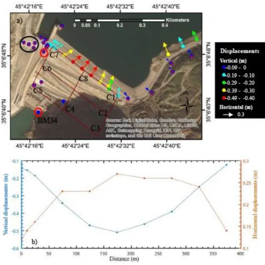
On November 12, 2017, the area nearby the dam in the Iranian city Sarpol Zahab was stroked by 7.3 magnitude earthquake, the epicenter was 30km from Darbandikhan Dam. The body of the dam was directly affected, cracks occurred in the body of the dam. The quake was followed by 53 aftershocks. Surveys were conducted by the Department of Surveying after the earthquake. There were cracks and settlements in some locations, especially at the top of the dam where the largest horizontal displacement was 27cm in the center of the dam. On the left side, it reached 14 cm and on the right side 12cm. Dam body at the top moved toward the center of the dam and to the northeast and north-west direction. While, the vertical displacement was varied from 50cm in the middle of the top and it was varied from 15 to 45cm at the sides as shown in Figure 11 [17].
The movement included the rocks on the right-side mountain, some of which were fallen near the dam and the administration building, and the most dangerous of what had fallen on the spillway channel. These rocks, which are large in size, pose a future danger in the event of repeated tremors or slippage due to unstable positions. The most important threat is the possibility of damaging the gates or important elements of the dam. Figure 12 shows the effects of the earthquake in late 2017 in terms of cracks in the body the main dam as well as the fall of rocks on the channel of the spillway [6, 18].
Among essential needs of the currently is to re-evaluate the safety of the dam and the level of storage under the current circumstances, after exposure the dam site to the earthquake that exceeded the estimations. According to the consultant Binnie and Partners in 1987, the dam could resist an earthquake up to 6.5 degrees, but what happened in 2017 is and earthquake of 7.3 degree at a distance of 30km. A decision had been made to reduce the operational level, until the evaluation and
recommendations were made by a technical authority. However, during the flood season of 2019 there was uncontrolled rise of the dam levels to the point where the spillway was operated.
Figure 11: Horizontal and vertical displacement in Darbandikhan Dam body after the earthquake in November 2017. (Source:[17]).
Figure 12: Aftermath of the earthquake in November 2017 at Darbandikhan
Dam; a) Right: cracks in the main dam body b) left: group workers are demolishing a stone that fallen in spillway chute from the adjacent
mountain.(Source:[18]).
Land sliding in the right side of the lake is one of the most important issues in Darbandikhan Dam, this has been diagnosed during the construction of the dam, and measures were taken in terms of increasing the side slope of the dam body. The sliding occurred after five years of lake operation, where the sliding observed at 300 meters from the body of the dam on the right side, it was founded in 1967 that the affected section extends 350m long and 200m wide with a depression for about 1.5m. This sliding could make a mass of soil equivalent to 2 million cubic meters. The sliding was caused by precipitation occurred due to an intensive rainfall of 126mm lasted seven days, and there was further rainfall between November 1969 and January 1970 [11]. Figure 13 shows the land sliding on the right of Darbandikhan Lake.
Figure 13: Land sliding on the right of Darbandikhan Lake.[(Source:[11])] As a result, the French consultant Coyne & Bellier and Iraqi company Dar Baghdad to had assessed the situation regarding the sliding, and after the study, they submitted the designs and recommendations for remedies in 1975. The main conclusions is that if a failure to stabilize the land sliding occurred, the movement of the soil mass towards the dam body may cause to:
1. The closure of the spillway and the tunnels inlets, which obstructs the flow and this cause a great risk in the flood season.
2. When the lake reaching its maximum level, the land sliding might generate water wave that overflow above the body of the main dam.
In order to address this risk, the consultant recommended the following:
1. Reduce the size of the sliding block and reach to elevation of 448 m a.s.l. 2. Carry out soil stabilization and drainage systems for the area under
consideration.
3. Determination of 460m a.s.l. as a minimum operating elevation for the dam lake.
4. Drilling 9 horizontal wells attached to pumping units to reduce moisture content in the affected area.
The implementation of the recommendations was initiated. Later, the dam was re-evaluated by the same company and Binnie and Partners until 2006, where Coyne & Bellier had presented recommendations after a new assessment of the dam. The recommendations are summarized as follows:
1. Determination of 450m a.s.l. as a minimum elevation for the operation of the lake, considering that the amount of reduction water levels is no more than 10cm/day.
2. There is urgent need to implement surface drainages for the affected area. 3. There is urgent need to clean and maintain horizontal wells.
4. Continuous monitoring and recording of pumping data from wells.[11] Another sliding was observed on the left side of the lake near excavations dumping site, 400m away from the dam axis. On-site investigations have been carried out and measures have been taken such as drilling horizontal wells. This slippage and other slips at the edges of the roads leading to the dam do not pose a danger to the safety of the dam [11].
In 2008, fish poisoning occurred in the lake parts near the confluence of the Tanjero tributary. The analysis indicated that heavy metals were present in the water samples, which are pollutants from industrial and municipal waste [19]. It should also be noted that the circumstances of the fighting led to the lifting of the gates of the dam and emptying the lake in 1988, the gates were later re-installed [20].
6. Hemrin Dam
Hemrin Dam, Darbandikhan Dam, and Diyala Barrage bring out an integrated hydraulic system to exploit Diyala River and the investment of agricultural land within the boundaries of the river. The idea of constructing a dam at the intersection of Diyala River with Hemrin Hills has been discussed since the 1930s and several places have been investigated. As the catchment area downstream Darbandikhan dam up to Hemrin Dam equals to 12760km2, this encouraged to think about the benefits of building the dam. In 1959, during the study of Sir M. MacDonald Consulting Company to Diyala River basin, a Reservoir of 2.27 billion cubic meters capacity was proposed at elevation of 105m a.s.l.
In 1966, Energoprojekt, a Yugoslavian company was commissioned to study the dam project and conduct the necessary investigations. The company submitted its report in 1970. After the flood of Diyala River in 1974, the dam project came back and Energoprojekt entrusted to carry out additional investigations and final designs. The study and designs were presented in 1976. The same year, Hydrogradnja Company had commenced to carry out the works of the project, while Energoporjekt cooperating with Iraqi authorities had conducted the supervision of dam construction. The dam was completed in June 1981.
Hemrin Dam project consists of a main dam with a clay core, a height of 40m and a length of 3360m. The operational level of Hemrin Dam is 104m a.s.l., the total storage size 2.06 billion cubic meters of which 2.04 billion is live storage. The dam has a gated spillway controlled by five radial gates with dimensions of (10.6×12.5) m for each gate; the maximum discharge of the spillway is 6800m3/s at the highest flood level which is 107.5m a.s.l. Figure 14 shows the spillway gates of Hemrin Dam. The dam has also 4 irrigation outlets with total discharge of 250m3/s. There are also, hydroelectric plant with two Kaplan turbine units and total generation of
50 MW. Further, Inspection tunnels are inside the dam's body to lead to power house and irrigation tunnels [2, 3, 12].
Figure 14: Spillway gates of Hemrin Dam, view from the downstream. (Source:[6]).
In addition, there is also a fuse plug dam (Saddle Dam) which works as an emergency spillway with a discharge of 6000m3/s, where the water diverted to Saladin flooding course that lead to Schweicha northern depression [20]. The project also included Sadiyah protection dykes to protect the city of Sadiyah, adjacent to the lake of the dam. It should be noted that Khanaqin-Baqubah highway is passing inside the dam lake, the road has been built by constructing embankments in the lake, and there is a bridge in the middle allows the water flow between both sides of embankments.
7. Haditha Dam
Haditha Dam is the only dam on the Euphrates River in Iraqi territories, and it's the second largest storage dam now after Mosul Dam. The dam is one of the most important and successful dams in terms of its role in controlling the releases in the Euphrates River reach, as well as the successful design and unique technical procedures adopted during the construction of the dam.
Habbaniyah project implementation for some extent had delayed the interest in the construction of a storage dam on the Euphrates River. The first attempt to introduce
this subject was submitted by Iraqi Engineer Vahi Sevian in 1945, he proposed in his report build a storage dam in the Upper Euphratesreach. The proposal included two sites: the reservoir of the first dam extends from city of Rawa up to Syrian border, and the second proposal for a dam in Khan Al-Baghdadi, where two sites had proposed, one of them causing the inundation Haditha city. The subject came back to the forefront in 1958, when the area was investigated for the construction of a dam north of Hit city by an Iraqi team, where four sites had proposed on Euphrates [12].
The presence of the Soviet side in doing the irrigation plans and studies with the beginning of the republican era, hence; Technopromexport Company was entrusted to study a proposal of the dam on Upper Euphrates in Iraq. The preliminary suggestions included; first proposal is the building of two dams in Rawa and Haditha to avoid the flooding of the city of Anah and Rawa and, while second proposal is one dam in Haditha city, which is adopted.
Studies and evaluation had been continued by Technopromexport and Swiss consultants. Finally, the contract was signed for the study and design of Haditha Dam between the Iraqi Ministry of Irrigation and Technopromexport Company on 26/11/1947. The study and additional investigations were completed in 1979. As a result of filling Haditha reservoir, water has to submerge Anah city and parts of the city of Rawa and many villages in the basin of the river, as well as many of the ruins in the area, where one of the most important is Minaret of Castle, which was dismantled and moved to a new location [21, 22]. Figure 15 shows the Minaret of Castle that had been moved to a new place. Also, the project included the construction of the new Ana city and the construction of new villages and farms for citizens who have to leave their homes [21].
Dam works started since 1977 and completed in 1988, the initial works began before the completion of studies, such as roads, camp, and various infrastructures of the dam site. Detailed design and implementation of the hydroelectric plant were entrusted to the Yugoslav company Energoprojekt. While Technopromexport carried out the other designs and general supervision of the project in cooperation with Directorate General of Dams at the time. The use of Mealy Dolomite as a core material for the earth fill body of the dam was the first time used in the dam in the world, also, it's the first time to use asphaltic diaphragm with this materials for. This exceptional design required more time for the necessary tests and research [23].
Figure 15: Minaret of Castle before moving due to inundation of Anah city. (Source:[22]).
Haditha Dam project consists of the main dam with mealy dolomite core and asphaltic diaphragm in the middle, the core is shelled with mixed gravel, and the dam body lined with concrete from the upstream and it is lined with concrete blocks from the downstream as a riprap. The dam body composed of three parts, two earth fill parts and the middle concrete part. The right part has length of 3230m, the left part length is 495m, and the concrete part which constructed in the river section has a length of 580m which includes most of the concrete parts such as spillway, power house, and bottom outlets. The tallest height of the dam body is 57m and its total length is 8950m. The top of the dam elevation is 154m a.s.l. The lake of the dam has a capacity of 8.2billion cubic meters at the maximum operational level of 147m a.sl., the live storage is 5.8 billion cubic meter. Dam includes also the spillway which controlled by radial gates, the spillway consists of 6 openings of 16 m width, the maximum discharge of the spillway is 11000 m3/s at elevation of 150.4 m a.sl., which is the maximum flood elevation. There are two bottom outlets with dimensions of 4m×6m and discharge of 500m3/s, at the minimum operating level of 112m a.s.l. [2, 21, 23]. Figure 16 shows the middle section of Haditha Dam.
Figure 16: Concrete Section of Haditha Dam, view from the downstream. (Source:[6]).
Among the most important Haditha Dam installations is the hydroelectric plant, which includes 6 Kaplan turbine units with a capacity of 570 MW and a total discharge of 2.034 m3/s [2, 24].
The dam includes two grouting tunnels for both sides. Regarding the grouting, a curtain grouting was implemented with two lines and depths up to 80 m. Also, blanket grouting was carried out under the foundations of the dam and at depth of 10 m at the bed of the river, and 5m deep under the dam. The seepage control system in the Haditha Dam is the Relief Wells, which are distributed in the downstream of the dam body. The dam is also provided with piezometers and sensors [8].
In general, Haditha dam does not suffer from major problems, but needs for comprehensive technical evaluation after more than 30 years of operation and requires the maintenance and rehabilitation for piezometers.
In comparison with Mosul Dam, Haditha dam has successful designs and measures in term of foundations treatment, especially the overcoming of karstification problem. Where the measures taken in the Haditha Dam have succeeded more than what is achieved in Mosul Dam, and for the purpose of comparison between the two dams, the following points are presented:
1. The two dams are located on the Arabian plate, where the Mosul Dam is located within Fatha geological formation, while Haditha Dam is located within the Euphrates geological formation.
2. Both of the dams were built on sedimentary rocks where the karst activity is scattering beneath. Karst layer sequencing extends in Mosul dam site for
300m, while it extends in Haditha Dam for 50m.
3. Mosul Dam foundations have gypsum layers, while Haditha Dam foundations have limes layers, where the former is more soluble.
4. There was no timetable for conducting geological investigations in Haditha Dam, the work were done with all necessary to make the required tests or investigations for developments, and it did not happen in Mosul Dam Project [1, 8].
8. Conclusion
Six decades after the opening of the first dam in 1959 on Lesser Zab River, the comprehensive experience has revealed many practical lessons and observations on dam projects in Iraq. The most prominent of which are:
1. The construction of the dams in Iraq was initiated when Development Board had commenced, where necessary funds allocated, and appropriate administration and legalization were adopted to build the dams that served the country. The most productive period in term of dams' construction is the decade of 1980s.
2. One of the main duties of Directorate General of Irrigation which is dominated by British engineers until the end of World War II is to prevent the risks of flooding, and the normal procedure was to divert water to the natural depressions, such as Tharthar and Habbaniyah. This was adopted in the 1st half of 20th century. Later, the dams had reduced the technical and economic feasibility of the natural depressions development.
3. Building of large storage dams was a success in terms of planning and implementation. Despite the problem of Mosul Dam foundations, that does not eliminate the big successes in all other locations and in Mosul Dam itself with respect to the other components of the dam and the benefits produced by dam operation. These dams have provided services which cannot be compensated in the seasons of drought that has befallen the country.
4. Ministry of Irrigation or Water Resources did not work according to the required procedure regarding the maintenance and inspection of the dams. There is no comprehensive maintenance programs are part of the operation of the dam, where many actions made after the evolution of technical issue. Many essential maintenance allocations are often under the authorities' investment budget. While maintenance is a part of the dam operation. 5. Most of the large dams require leakage treatments, installing sensors, and
maintenance of the meters, and other technical components.
6. It is remarkable that Adhaim dam hydropower station does not completed yet. Despite the abundance of funds, many of which were spent on forestation and housing projects for some dams where the implementation has not started yet. This example reflects the lack of technical and economic priorities that contribute to maximize the feasibility of dam constructions, and there are other examples in this regard.
7. Sediments occupy space from the bottom of the main reservoirs within the dead storage and the reservoir sides; there is no comprehensive and integrated bathymetric survey for all dams, except for Mosul Dam, which are the efforts of a graduate student.
References
[1] Adamo, N.; Al-Ansari, N.; Sissakian, V.; Knutsson, S.; Laue, J. Mosul Dam: Full Story (in Arabic); 2018;
[2] AL-Simawi, H. Encyclopedia of Dams in Iraq; 2008; [3] USACE Iraqi Dam Assessments; 2003;
[4] Trevi Group Website Available online: http://www.trevigroup.com/en/ (accessed on Jun 1, 2019).
[5] Kelley, J.R.; Wakeley, L.D.; Broadfoot, S.W.; Pearson, M.L.; Mcgrath, C.J.; Mcgill, T.E.; Jorgeson, J.D.; Talbot, C.A. Geologic Setting of Mosul Dam and Its Engineering Implications; 2007;
[6] Resources, M. of W. Ministry of Water Resources Official Page on Facebook Available online: https://www.facebook.com/waterresources2/?__tn__=kC-R0.g&eid=ARB_vikp82C0hDpmLSD5DywN37xKMKk8imYIn2PhYPeUh2
KW2Kj_a4mh-PBME0E2_ymGK4R0-TzxN71H&hc_ref=ARTjh7GWKUgcCsFz1D3H1C92eUW9dbL4UdO_cA_ vttchORbUsIHWsOhQy4rbVssSgrk&fref=nf&__xts__[0]=68.ARAJtjsqk9j7 gRAv (accessed on Jun 14, 2019).
[7] Sissakian, V.; Adamo, N.; Al-Ansari, N.; Knutsson, S.; Laue, J.; Elagely, M. A Comparative Study of Mosul and Haditha Dams, Iraq: Geological Conditions. J. Earth Sci. Geotech. Eng. 2018, 8.
[8] Adamo, N.; Sissakian, V.; Al-Ansari, N.; Knutsson, S.; Laue, J.; Elagely, M. Comparative Study of Mosul and Haditha Dams, Iraq: Foundation Treatments in the Two Dams. J. Earth Sci. Geotech. Eng. 2018, 8.
[9] Annunziato, A.; Andredakis, I.; Probst, P. Impact of flood by a possible failure of the Mosul dam; 2016; Vol. jrc techin;
[10] Issa, I. Sedimentological and Hydrological Investigation of Mosul Dam Reservoir, Lulea, 2015.
[11] SMEC Dokan and Derbendikhan Dam Inspections; 2006;
[12] Sousa, A. Baghdad Floods in the History: Volume 3 (in Arabic); 1966; [13] Esri ArcGIS Online Available online: Figure 5%22 shows the satellite view of
Samarra Barrage and Tharthar Regulator. (accessed on Jun 13, 2019).
[14] Hassan, R.; Ali, A.; Hazim, A.; Al-Ansari, N.; Knutsson, S. Reduction in the Storage Capacity of Dokan Dam Reservoir. In Proceedings of the Proceedings of the 1st Springer Conference of the Arabian Journal of Geosciences (CAJG-1), Tunisia 2018; 2019; Vol. 5, pp. 429–432.
[15] Resources, M. of W. The Encyclopedia of Irrigation in Iraq, February 1918-February 2005; 2005;
[16] Ministry of Irrigation The Implemented Projects from 1/1/1996 to 1/6/2001; 2001;
[17] Al-Husseinawi, Y.; Li, Z.; Clarke, P.; Edwards, S. Evaluation of the Stability of the Darbandikhan Dam after the 12 November 2017 Mw 7.3 Sarpol-e Zahab (Iran–Iraq Border) Earthquake. Remote Sens. 2018, 10, 1426.
[18] Darbandikhan Official Account on Facebook Available online: https://www.facebook.com/DerbendikhanDam (accessed on Jun 1, 2019). [19] Ararat, K.; Mehdi, R.A.; Falih, H.A.; Maher, A.M.; Bachmann, A.
Darbandikhan lake poisoning event; 2008;
[20] Ministry of Irrigation A Report of the Year 1988 Flood; 1988;
[21] Technopromexport Haditha Project on the Euphrates River-Technical Design, Volume I:Summary; 1978;
[22] Saiid, M. The ancient sites in the Basin of the Hadithaa Dam on the Euphrates. 1978.
[23] Adamo, N.; Sissakian, V.; Al-Ansari, N.; Elagely, M.; Knutsson, S.; Laue, J. Comparative Study of Mosul and Haditha Dams in Iraq: Different Construction Materials Contribute to Different designs. J. Earth Sci. Geotech. Eng. 2018, 8.
[24] Li, J.; Ameen, A.M.S.; Mohammad, T.A.; Al-Ansari, N.; Yaseen, Z.M. A systematic operation program of a hydropower plant based on minimizing the principal stress: Haditha dam case study. Water (Switzerland) 2018, 10, 1–19.
![Figure 1: General view of Mosul Dam (Edited by Author). (Source:[4]) Mosul Dam is a giant project that includes a number of details, such as fuse-plug dam on the left side of the main dam, grouting tunnels, electric transformers, piezometers](https://thumb-eu.123doks.com/thumbv2/5dokorg/4268867.94645/4.813.108.711.215.521/general-project-includes-grouting-tunnels-electric-transformers-piezometers.webp)
![Figure 7: Satellite view of Dokan Dam (Edited by Author). (Source:[13]).](https://thumb-eu.123doks.com/thumbv2/5dokorg/4268867.94645/10.813.106.706.377.730/figure-satellite-view-dokan-dam-edited-author-source.webp)