1
THE GOTLAND PAPERS
Selected Papers from the VII
International Conference on
Easter Island and the Pacific
Migration, Identity, and Cultural
Heritage
Gotland University, Sweden
August 20-25, 2007
Editors: Paul Wallin and Helene Martinsson-Wallin
Gotland University Press 11 Gotland University Press 11 Gotland University Press 11 Gotland University Press 11 Issue Editor
Issue Editor Issue Editor
Issue Editor: Paul Wallin and Helene Martinsson-Wallin 2010 Series Editor
Series Editor Series Editor
Series Editor: Åke Sandström, Gotland University Editorial Committee
Editorial Committee Editorial Committee
Editorial Committee: Åke Sandström & Lena Wikström Cover design:
Cover design: Cover design:
Cover design: Daniel Olsson & Lena Wikström Cover drawing
Cover drawing Cover drawing
Cover drawing: Easter Island petroglyph redrawn by Paul Wallin ISSN
ISSN ISSN
ISSN: 1653-7424 ISBNISBNISBN: 978-91-86343-07-1ISBN Web
Web Web
2
Gotland University
in Collaboration with
Easter Island Foundation
THE GOTLAND PAPERS
Selected Papers from the
VII International Conference
on Easter Island and the Pacific:
Migration, Identity, and Cultural Heritage
Title page drawing of Släbro Runic Stone from Sweden, back cover drawing of
fragmented moai with inlaid eye from ‘Anakena, and drawing of moai in Rano Raraku on
page 9 all by Paul Horley.
3
CONTENTS
Introductory Material
Opening Remarks
Dave Rose. . . .11
Opening Address
Leif Borgert. . . .12
Welcome Speech at Visby Strand Congress Hall
Helene Martinsson-Wallin. . . 13
Editors Preface
Paul Wallin and Helene Martinsson-Wallin. . . .14
Keynote Address:
A Palynologist Looks at the Colonization of the Pacific
John Flenley.. . . .15
Chapter 1: Easter Island Archaeology
Re-dating Ahu Nau Nau and the Settlement at ‘Anakena, Rapa Nui
Paul Wallin, Helene Martinsson-Wallin & Göran Possnert. . . .37
Ahu Motu Toremo Hiva (Poike Peninsula, Easter Island): Dynamic
Architecture of a Series of Ahu
Nicolas Cauwe, Dirk Huyge, Dominique Coupé, Alexandra
de Poorter, Serge Lemaitre, Wouter Claes, Morgan De Dapper,
Johnny de Meulemeester, & Reem al-Shqour. . . .47
Computer Modeling and Visualization of Vinapu Ceremonial Center
Paul Horley. . . .57
The Easter Island Cultural Collapse
Charles M. Love.. . . .67
GIS Applications in Easter Island: Geodetic Adjustments and Survey Maps Accuracy
4
Chapter 2: Easter Island Paleo-botany and Landscape Approaches
The Vanished Palm Trees of Easter Island: New Radiocarbon and
Phytolith Data
Claire Delhon & Catherine Orliac. . . .97
Plant Microfossil Analysis of Deposits from Te Niu, Rapa Nui,
Demonstrates Forest Disruption c. AD 1300 and Subsequent
Dryland Multi-cropping
Joan A. Wozniak, Mark Horrocks, & Linda Cummings. . . .111
Botanical Identification of 200 Easter Island Wood Carvings
Catherine Orliac. . . .125
Empirical Assessment of a Pre-European Societal Collapse on Rapa Nui
(Easter Island)
Mara A. Mulrooney, Thegn N. Ladefoged, Christopher M. Stevenson,
& Sonia Haoa. . . .141
On the Road of the Winds: Journeying Across the Blue Water of the
Pacific, and Along the Roads of Rapa Nui
Colin Richards. . . .155
Back to the Sea: Rapa Nui’s Ahu Seascapes
Sue Hamilton. . . .167
Chapter 3: Easter Island Anthropology and History
When Home Is the Navel of the World. Lives and Futures of Young
Rapa Nui — Or, What a Not So Young Anthropology Novice Thinks
She Might Finally Think About This
Olaug Irene Røsvik Andreassen.. . . .183
Why Are We Living in the Past?
Patrick M. Chapman & María Eugenia Santa Coloma.. . . .189
A Museum Exhibition as a Way to Express Identity Proposed
“He A´amu Tupuna, He Mana´u a Mu´a”
5
Easter Island in the Comics: 65 Years of an Island’s Career in the
American Imagination
Beverly Haun. . . .205
Comparative Structural Analysis of Rongorongo Script and Rapa Nui Songs
Paul Horley. . . .217
Preliminary Internal Evidence for Series of Procreation Triads in Easter
Island’s Rongorongo Corpus
Steven Roger Fischer. . . .225
Deciphering Old Catalogues: Rediscovery of the Rapa Nui Figures from
St. Petersburg’s Kunstkamera
Pavel L. Belkov. . . 231
A Virgin’s Birth on Easter Island: Revisiting Maria, Madre de Rapa Nui...Again!
Joan Seaver Kurze. . . .241
Welcome Abord the ”Scholar-ship”
Marla Wold . . . .253
Chapter 4: Eastern Pacific Archaeology and
Polynesia / New World Contacts
Archaeological Art at Nu‘u, Maui, Hawaiian Islands: Rock Images
Within Polynesian Settlement Landscapes
Sidsel Millerstrom. . . .259
Time and Temples: Chronology of Marae Structures in the Society Islands
Reidar Solsvik & Paul Wallin. . . .269
Evidence of an Early Amerindian Contribution to the Polynesian
Gene Pool on Easter Island
Erik Thorsby . . . .285
The Polynesia – Mapuche Transpacific Contact
José Miguel Ramírez Aliaga. . . .297
Polynesians in the New World: The Chumash Connection and Beyond
Terry L. Jones. . . .307
Linguistic Evidence for Prehistoric Polynesian-American Contact
6
Chapter 5: Western Pacific Archaeology and Anthropology
Archaeological Investigations of a Stone Platform at the Malaefono
Plantation, Upolu, Samoa
Helene Martinsson-Wallin & Joakim Wehlin. . . .327
The Tell-tale Adze: Connecting Samoan Basalt Adzes to the Investigation
of Political Complexity
E. Quent Winterhoff. . . .339
The Tutuila Basalt Export Industry and the 5600 km Distribution of Samoan Adzes
at ~700-600 BP
David J. Addison. . . .347
The Lapita Settlement of Samoa: Is a Continuous Occupation Model Appropriate?
David J. Addison & Alex Morrison. . . .359
A GIS Based Model for Locating Lapita Aged Settlements in American Sâmoa
Alex E. Morrison, Timothy M. Rieth, & David J. Addison. . . .377
Towards a Relative Chronology of the Pottery in Mbuke Island
in the Manus Province of Papua New Guinea
Mads Ravn. . . .393
Cranial Evidence of Ethnicity on the Sepik Coast, Papua New Guinea
Michele Toomay Douglas & Ann L. W. Stodder. . . ...407
Perspectives on Pre-contact Human Introduction of Woody and Forest
Species in the Pacific Islands: Prospective Ethno-Anthracological
Research in New Caledonia
Emilie Dotte, Christophe Sand, Jacques Bolé, André Ouetcho,
& David Barret. . . .431
Language Contact in the Reef Islands: Keeping One’s Distance at Close Quarters
Åshild Næss & Even Hovdhaugen. . . 455
Mythicization of Tsunami in the Ryukyu Islands: A Process of Seascape
Formation in Island Societies
7
Chapter 6: Miscellaneous Papers
Swedish Large-Scale Historical Maps as Sources for Archaeological
Research: Examples from Gotlandic Maps from 1693-1705
Gustaf Svedjemo. . . .475
Landscapes of Complexity: Data Visualization and Spatial Analysis
of Prehistoric Shell Works Sites, Ten Thousand Islands, Florida
Margo Schwadron. . . .491
Ancient DNA Preserved in 5000 Year Old Hedgehog Bones
Magdalena Fraser, Sabine Sten, Gustav Malmborg & Anders Götherström. . . .507
Article 55 Directions: Developing and Revising Tentative Lists
and Their Potential Influences
9
Introductory Material and
Keynote Address
11
Opening Remarks
Dave Rose
Easter Island Foundation
Ladies and gentlemen,
On behalf of the Easter Island Foundation, I would like to welcome you to the VII International Conference on
Easter Island and the Pacific. I think we are all looking forward to an interesting and informative meeting that
will introduce new and exciting ideas on migration, identity and the cultural heritage of the Pacific Island people. The meeting should give you the opportunity to meet colleagues you may only know as references in academic papers and to renew old friendships and to begin new ones.
The Easter Island Foundation is proud to be a sponsor of this conference along with the Gotland University, and to be a participant in the communication of the latest developments in Polynesian archaeology and anthropology to the most knowledgeable academic and field researchers on this subject. The Easter Island Foundation not only supports conferences such as this one, but we also provide grants for research on Rapa Nui, some of which may be presented at this very conference.
We have always supported research activities but ever since our formation about twenty years ago with the goal of establishing the William Mulloy Library, we have had the additional goal of helping the Rapa Nui people directly. Especially in recent years our activities have included scholarships to worthy Rapa Nui students to support their college education and hopefully to bring their learning and experiences back to Rapa Nui to bring additional benefits to the greater Rapa Nui people. In fact our largest single funding item this year has been our scholarship grants. Additionally, we have recently expanded our activities into the growing ecological problems on the island and to the increasing issues related to sanitation and waste control.
The Easter Island Foundation also publishes the Rapa Nui Journal and books on Polynesia and Easter Island. We have an extensive list of available publications which were provided in your registration material and I also invite you to browse our website <www.islandheritage.org>.
We believe the Easter Island Foundation is a significant contributor to the discovery of new knowledge about Rapa Nui and the Rapa Nui people and we would like to continue that process into the future. To this end I would like to invite you to be a part of this process by supporting these very worthwhile efforts by contributing to the Easter Island Foundation. The benefits you will receive will be not only the Rapa Nui Journal, which goes to contributors meeting a minimum level, but in being part of the research and preservation of Rapa Nui and its archaeological treasures. If you would like to contribute to the Easter Island Foundation, please see me or any board member during the conference, or visit <www.islandheritage.org>. I hope everyone takes full advantage, not only of the activities at the conference, but also I hope you take the time to explore some of the amenities available on this beautiful island. There are many archaeological treasures to be explored across the island including Medieval city walls and ruins, burial grounds from the Stone, Bronze, and Iron Ages, and Viking treasures.
So, once again, welcome to the conference. Thank you very much. August 2007
12
Opening Address
Leif Borgert
Gotland University
"No Man is an island", they say.
The concept of Island is often understood as a symbol of isolation. Therefore, it is a pleasure for me to note that academics on the island of Gotland and Easter Island over the years have connected to each other in a way that is no less than impressive. The geographical distance between the sites is great, but the collegial curiosity of sharing knowledge about Man and Society is even greater.
One of the main academic profiles of Gotland University is the study of archaeology. Already in the childhood of the University, connections between Gotland and Easter Island were created. Inger Österholm, archaeologist and former pro-rector of Gotland University, took a leading role in those efforts. Today we offer a highly qualified educational program in International Archeology, attractive to many students from Sweden and abroad. Research conferences are important arenas for exchange of ideas, methods and results. The current 190 conference delegates are from 27 countries and, for the first time on European ground, take the opportunity to share their insights from a cultural perspective on topics concerning Easter Island and the Pacific.
13
Welcome Speech at Visby Strand Congress Hall
Helene Martinsson-Wallin
Gotland University
Iorana Korua, Pehe Koe?
Welcome friends and colleagues to the VII International Conference on Easter Island and the Pacific. Special welcome to our young students and researchers from Rapa Nui, Samoa, Tokelau, New Caledonia, and New Zealand, and our friends attending from Zanzibar. You have come far to participate in this gathering. You are the future of your islands and it is your task to bring the research results presented here back to your island communities. You are the future and now we "old folks" can retire and finally enjoy a tropical setting without thinking about finding potential prehistoric sites, looking for Lapita sherds, basalt adzes, or obsidian flakes. However, it is doubtful if we can be stopped in our eagerness to carry out further research, but maybe we should, instead take up the position as supporters in the background!
You might all be wondering what a conference on the Pacific is doing in a place like this; in the Northern Hemisphere close to the North Pole; but an Island is an Island is an Island — and, in a sea of islands, Gotland actually has more in common with the Pacific Islands than first meets the eye.
Gotland Island was formed in a tropical sea c. 450 million years ago at the time of the great continent of Pangea, when the equatorial line was situated here. Remains of a coral reef are to be found as stone pillars on the coast of Gotland. We also find many fossils of animals and plants on Gotland beaches that are currently and commonly discovered living in tropical waters.
And the Gotlandic Saga tells us that:
Tjelvar was the first man who found Gotland, but it was hidden and dark. During the days it disappeared in the sea and during the nights it rose up again, but Tjelvar brought fire and light to the Island and from that day, it never sank in the sea again. Tjelvar had a son named Havde. He and his wife, White Star were the first to reside in Gotland. She had a dream of three snakes appearing from her bosom and Havde 's interpretation was: all are connected in circles and this land should be settled by our three sons and their names should be Gute, Grajper and Gunfjaun.
Since the time of Tjelvar major changes have occurred especially changes of the landscape. The place where Gotland University is located was once under water. The people who populated Visby c. 5,000 years ago could use this place to fish for huge cod or go further in their canoes to trade with South Scandinavian tribes to obtain precious flint or, aiming for the Baltic shores, to get a hold of the amber that probably was considered the gold of the time.
Later on, c. 1,000 years ago, Viking ships sailed towards the east and some of them subsequently returned home with large amounts of silver coin which was stashed away in the ground. Now and then Gotlandic farmers come across small (and sometimes large) hoards of silver coins. The largest silver hoard in Europe is the Spilling's Hoard of 68 kg found in the north of Gotland in 1999. It is now on display at the magnificent Historical Museum which also houses the unique picture stones displaying the sagas of the Vikings from Gotland. During medieval times trade ships belonging to the trading union of the Hanseatic League anchored in the Visby harbor and the city was a wealthy place protected by a wall. The land is still rising on Gotland and, in the former harbor area, a meeting place and center of knowledge — Gotland University and the Wisby Strand Conference Centre — has been created on reclaimed land. Close by, in the Almedalen Park, is a political meeting place where every important Swedish politician has spoken since the late Prime Minister Olof Palme initiated the politician week on Gotland several decades ago.
The themes of the VII International Conference on Easter Island and the Pacific are Migration, Identity, and
Cultural Heritage — from island perspectives. We have never experienced such an extensive migration
movement than today, especially south to north movements of people who are seeking better living conditions for themselves and their families. With globalization and growing environmental problems, we might also see other types of migration from areas at risk of turning into deserts or islands and coastal stretches that might disappear into the sea. The migrations in the Pacific area have been and are extensive. In the past the people moved around with the aid of the canoe, the "vaka", and, with the skills from the master navigators who relied on
14
the stars, the sun, and the moon, they managed to populate every little island in the great Pacific Ocean. How, when, and why this happened are issues to be discussed at this Conference.
Identity (or belonging) and cultural heritage are two themes closely connected that will be discussed and experiences on this topic will be shared in the Three Worlds Meet workshop. In a way, the participants of this Conference, who represent 28 different nations, really speak for themselves and show us that the Pacific or the Oceanic area really is a multicultural place. As such it also carries a "backpack" which deals with the concept of origins and what is original, colonial, and post-colonial. This raises issues of creolization and multiculturalism and the problems and possibilities that all of this implies.
Initially I referred to the notion that an Island is an Island is an Island and, in the Sea of Islands, Gotland has many issues in common with Rapa Nui, Samoa, and Zanzibar. Especially in that they are remote and exotic but at the same time tourist places populated by people who are struggling to keep their identity and cultural heritage while also struggling to develop their islands as modern states to fit into our globalized world.
Editors Preface
Paul Wallin and Helene Martinsson-Wallin
Gotland University
When Gotland University in collaboration with Easter Island Foundation arranged the VII International
Conference on Easter Island and the Pacific in Sweden we sometimes thought that it was maybe too far from the
focus of the conference; Rapa Nui. However, as organizers, it was fantastic to see so many collegues and especially the young participants of Polynesian decent coming to our little island in the Baltic Sea. The focus was as usual set on Rapa Nui archaeology, anthropology and history, but broader Pacific perspectives including East and West Polynesia, as well as Melanesia and American contacts were also discussed. - And nothing felt “far away”.
Since the general theme of the conference concentrated on issues of migration, identity and cultural heritage, the keynote speaker Professor John Flenley therefore opened the conference with a speech on how the Pacific was settled from his paleobotanical point of view that showed how human impacts change the islands landscapes. This perspective was of course a broad introduction to questions on migrations and identity. It was our intention that these issues came to be discussed, to open up views concerning contacts and interactions in the Pacific area and of course with the intriguing focus on the fantastic prehistory of Rapa Nui.
It is now a pleasure to be able to release the proceedings of the submitted papers that were presented at some of the 15 sessions. The papers in this volume are not following the sessions, but have instead been sorted into 6 Chapters following geographical areas, and the Rapa Nui papers are divided into three different categories ranging from prehistory to the present. The third theme concerning cultural heritage was especially discussed in the workshop called “World Heritage and Identity - Three Worlds Meet” where representatives of three World Heritage sites (Zanzibar, Visby and Rapa Nui) exchanged ideas on their experiences living in close connection to such sites. This Workshop will be published in Gotland University Press as a separate volume.
We will also take the opportunity to thank all the participants who came to the conference and made it all possible, as well as, the sponsors of the conference: Gotland University, Easter Island Foundation, Swedish Research Council, The Wenner-Gren Foundation and Gotland Municipality. Finally, we hope that the participants to the conference, as well as, those who could not partake, in this way will enjoy and take part of the papers presented in this volume.
Visby, 2010-10-20
15
Keynote Address:
A Palynologist Looks at the Colonization
of the Pacific
John Flenley
Massey University, New Zealand
Abstract – The paper considers palynological evidence for Late Holocene vegetational change in Polynesia, with special
reference to human impact. It relates this evidence to archaeological dates of colonization. Summary pollen diagrams are shown from Tonga, Cook Islands, Society Islands, Easter Island and New Zealand. It is concluded that there is a surprising level of agreement between pollen data and archaeology, though there is still dispute regarding Easter Island and New Zealand. In general, the hypothesis of migration into Polynesia via Tonga is supported, with a slightly later spread to Central Polynesia. Movements to Easter Island and New Zealand may be related to climatic changes. The long chronology is supported.
Introduction
It is appropriate that I should be giving this lecture in Sweden, since that is the country where Lennart von Post founded palynology in 1916, by being the first person to count fossil pollen grains from peat, and to relate the results to vegetational change (von Post 1916). The earliest recognition of signs of human impact in palynological data was also in Scandinavia, where Iversen (1941) recognised Neolithic forest clearances. Now palynology has spread around the world and has at last reached Polynesia. In this account I have attempted to adhere strictly to scientific principles, especially Ockham’s Razor (William of Ockham 1285 - ?1349) (Hypotheses are not meant to be multiplied beyond necessity) and the need to avoid the Affirmation of the Consequent (Aristotle 384 – 322 BC) (Absence of Evidence is not Evidence of Absence).
So how can we hope to distinguish in pollen diagrams between natural changes and anthropogenic (human-induced) ones? Occasionally, we are lucky enough to find pollen of crop plants or of human-associated weeds. In the absence of these, we may still detect disturbance in the vegetation. This may show itself in the form of secondary forest trees (e.g. Macaranga, Trema), but the disturbance may not necessarily be caused by people. We are fortunate, however, that natural fires are not at all common in Polynesia, so if disturbance is accompanied by charcoal, we may suspect human activity. Also, over a large area, changes resulting from climate are usually nearly synchronous, whereas human impact is usually patchy or progressive. However, if climate change were to trigger a human migration, then the effect could be synchronous. We need to understand something of where our pollen is coming from. Studies (Jacobson and Bradshaw 1981) have shown that in a small site (say a lake or swamp up to 100m diameter) most of the pollen is derived from the local area, perhaps 100 – 200m from the site. At the other extreme, a large site (say over 300m diameter) will give a generalised accumulation from the entire region, probably a 10km radius or more. Thus by deliberately choosing sites of different sizes, we can discover whether we are looking at local or regional changes.
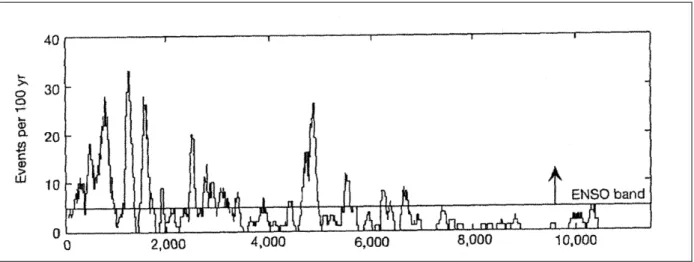
This paper looks at the palynological evidence for Late Holocene vegetation changes on some of the islands of Polynesia, with particular reference to human impact, and the correlation of that with archaeology. Polynesia is defined anthropologically: it is the region of the Pacific where the Polynesian people traditionally lived. It is roughly triangular (Figure 1), with the apices of the triangle marked by New Zealand, Hawai’i and Easter Island. Archaeology suggests (Figure 2) that the first colonists of the region, the Lapita culture, entered via Tonga at around 2600 - 3500 BP and then spread to Samoa. There was then a movement into Central Polynesia (Cook Islands, Society Islands, Marquesas Islands). Migration to the three vertices of the triangle is thought to be later, perhaps only within the last 1300 years or less. The actual dates of this last phase are hotly disputed (Spriggs and Anderson 1993; Hunt and Lipo 2006). Before looking at the pollen evidence, we should try to get some idea of possible climatic changes during the time people have been present. The most significant climatic influence appears to be ENSO, which brings drought to the tropical Pacific periodically. The area likely to be most affected is shown in Figure 3. We now know that the frequency of severe ENSO events has varied in the past (Allen 2006). The evidence for this comes from the measurement of erosion rates into Laguna Pallcacocha in the high Ecuadorean Andes (Moy et al. 2002).
16
The variation is very striking (Figure 4). The present rate is about 3 severe events per century. But in the past two millennia there have been three periods when the rate has exceeded 20 per century. These periods peak at c. 1600 BP, c. 1200 BP, and c. 750 BP. In between are periods with rates as low as or lower than the present. We must expect these extreme variations to have had drastic effects on the movements and survival of people. The paper will now proceed to consider the palynological data from some of the island groups for which data are available. This does not attempt to be a comprehensive review. I have chosen to use data with which I have some connection, and can therefore speak with more confidence.
Figure 1. Map to show the position and limits of Polynesia. After Irwin (1992).
Figure 2. Human dispersal patterns in Polynesia. The dates shown represent earlier interpretations now largely superseded. After Sutton (1994).
17
Tonga
Since Tonga is the island group nearest to Fiji, and reputedly the first part of Polynesia to be settled, it is appropriate to consider the evidence from this group first. There are two relevant pollen diagrams from Tonga. The first diagram is from Finemui swamp on the tiny (2 km diameter) coral island of Ha’afeva in the central Ha’apai sub-group of islands (Flenley et al. 1999). The pollen diagram (Figure 5) covers a time back to before 5770 ± 90 BP and is divided into five zones. A mixed, fern-rich rainforest assemblage shows incipient disturbance from near the top of zone FM 3. The boundary between zones FM 3 and FM 4 is dated to 2080 ± 60 BP. A further change, the rise of Cocos nucifera to abundance, is the start of zone FM 5, dated to 1220 ± 60 BP. The swamp is only 700m from the excavated Lapita site of Mele Havea, which dated back to c. 2600 BP (Burley 1997), so the c. 2080 BP date seems very reasonable as a minimum age for the start of human disturbance of the swamp area. The later date of c. 1220 BP may represent the changes caused by a volcanic ash shower which fell on the island (S. Cronin, pers. comm.), or could indicate an intensification of agriculture.
A further pollen diagram from the northern sub-group of islands, Vava’u (Fall 2005) shows forest disturbance and charcoal from 2620 ± 80 BP, which is concordant with the date of the Lapita culture in Ha’apai at c. 2600 BP Some Lapita data from Tonga are earlier than this (Burley et al. 1999), so the pollen dating is quite conservative.
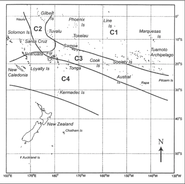
Figure 3. The effect of ENSO events on tropical Pacific Islands. C3 – Liable to severe ENSO droughts. C1 + C4 – Relatively stable climates (After Salinger et al. 1995, 2001).
18
Cook Islands
Several islands in the Cook group have been investigated palynologically. They include Rarotonga, Atiu and Mangaia. On Rarotonga, Karekare Swamp, an infilled lagoon on the north east coast, was cored to 9 m depth, representing over 8000 years of deposits. The pollen diagram from borehole KK4 (Peters, 1994) showed a sharp rise in particulate charcoal and Pandanus in the topmost zone, at a level dated (calibrated) to 2730 (2353) 2157 B.P. As, however, a level only slightly above this gave a date of 1133 (958) 791 BP, and there was a date inversion slightly further down the core, inwash of old carbon is suspected, and the date must be viewed with caution.
From the island of Atiu we have a clearer picture provided by the diagram from a small lake, Te Roto (Parkes, 1997). At a zone boundary dated to 1420 ± 45 BP, there is a sudden and dramatic replacement of Cocos nucifera by Gleichenia (syn. Dicranopteris) linearis, Cyperaceae and Gramineae, along with Casuarina equisetifolia. Even the pollen of Ipomoea batatas (sweet potato), which rarely preserves, was present in one sample. As the date is reasonably concordant with others in the sequence, it may be accepted as indicating the start of forest clearance of Atiu. Earlier changes in the diagram are considered to be natural.
An earlier date for human impact is revealed by the work on Mangaia. Mangaia is (like Atiu) one of the ‘makatea’ islands in which uplifted coral limestone surrounds an ancient volcanic core. Between the two are extensive swamps, and even a lake, Lake Tiriara. This was investigated in relation to a rockshelter excavation 1km away (Kirch et al. 1991, 1992, 1995). Lake coring yielded a 15m core dating back to 5810 ± 100 BP. Five other dates were concordant with this, suggesting no inwash of old carbon, and the δ13C values did not suggest that ancient carbon from the coral limestone was incorporated into the sediment. The pollen diagram is summarised in Figure 6. It shows striking changes at the start of Zone III about 1600 BP. Trees decline, ferns increase and weeds show a peak. The ferns include Dicranopteris (syn. Gleichenia) which now dominates large areas of the deforested basalt core of the island. There are also geochemical changes, such as the rise in iron (Fe) derived from the basalt, suggestive of disturbance. The decline of trees had (apart from a single point peak) actually begun somewhat earlier, perhaps from a date of 2450 ± 80 BP. Marginal cores confirmed that soil inwash had begun by 2400 BP, but material did not appear to have contaminated the lake core dates. A subsequent investigation by Joanna Ellison (Kirch and Ellison 1994) involved coring other swamps around the island. Those showed the regular inwash of soil materials from the basalt, as well as the presence of particulate carbon, all within the last 2400 years. Interestingly, particulate carbon was absent before that date, suggesting that natural fires had not occurred on the island during the mid-Holocene.
The dates of 1420 BP and 2400 BP are both earlier than the dates from the rockshelter, which appears to have been in use from c. AD 1000 to c. AD 1650 (Kirch 1997). Nevertheless, it seems that the palynology and charcoal records are more likely to indicate the age of initial human colonization of Mangaia, which may therefore be taken as c. 2400 BP.
Figure 4. Frequency of severe ENSO events over the last 10,000 years. Data from erosion rates in Laguna Pallcacocha, Ecuadorian Andes (After Moy et al. 2002).
19
Figure 5. Pollen diagram from Finemui Swamp, Ha’afeva Island, Ha’apai, Tonga. Only selected taxa are shown. After Flenley et al. (1999).
20
Society Islands
Pollen diagrams are available from Tahiti and Mo’orea. The Tahiti diagram is from Lake Vaihiria, an inland, upland lake formed by a landslip in one of the interior valleys. Perhaps because of the steep and slip-prone terrain, the radiocarbon dates from the two cores are confused, though a maximum age of c. 500 years may be suggested for the sequence (Parkes et al. 1992). The palynology is striking for the prevalence of Pteridophyte spores throughout, no doubt reflecting the abundance of ferns in the forest which surrounds the lake today. Despite this, some reduction of primary forest trees is evident in the central zone of the core (? c. 17th and 18th centuries AD) perhaps indicating human activity inland, for which there is archaeological evidence (Orliac 1997). Towards the surface, in the uppermost zone, there is some recovery of the woody vegetation (especially Urticaceae/Moraceae, Trema comp., Freycinetia sim. and Pandanus), which probably corresponds with the post-contact shift of the human population to the coast in the 19th century. Although this site is of no relevance in terms of human colonization date, it serves to show that even shifts of population may be registered in the pollen record, with historically verifiable dates.
The Mo’orea site (Lac Temae) is a piece of former lagoon which has become cut off and is now a brackish-water lake. The bottom half of the 15m core obtained is highly calcareous, with a rapid accumulation rate. The oldest date obtained is 1540 ± 100 BP at 11.5m depth. The pollen sequence (Figure 7; Parkes 1994, 1997; Parkes and Flenley 1990) can be interpreted in terms of human disturbance. The lower half of the sequence (Zone Tp I) shows a strong dominance of trees, especially Pandanus which is both wild and cultivated in Polynesia. There is nothing here which requires interpretation as human disturbance. Starting with zone Tp II, however, there is a peak of fern spores, along with degraded pollen of upland forest elements, suggesting disturbance of inland forests. Most remarkable is the presence of Colocasia esculenta (taro), an introduced cultivar. This surely suggests the presence of people. The date of 1210 ± 90 seems not unreasonable, though it may be queried on the grounds of possible incorporation of old carbon, from soil or coral limestone.
The zones above this seem to represent changing land use, under continuous human presence. Pandanus and Cocos appear to alternate, perhaps in response to local cultivation preferences. Further cultivated trees such as Terminalia, Hibiscus and Casuarina appear, along with introduced shrubs such as Cordyline and Acalypha, and weeds including Bidens, Ageratum, and Mimosa pudica. Colocasia is present again, and eventually post-contact introductions such as Stachytarpheta and Pinus/Podocarpaceae. The suggestion is of continuous human presence for the last 1200 years. There is, however, an interesting recovery of Pandanus and other primary forest elements in zone Tp IV, starting at an interpolated age of c. 800 BP and suggesting a reduction in human impact. One might speculate that this could correlate with ENSO-induced droughts becoming more common at that time
Figure 6. Pollen diagram from Lake Tiriara, Mangaia, Cook Islands. Only selected taxa are shown. After Kirch et al. (1991, 1992, 1995).
21
(Allen 2006) and inducing out-migration of people, possibly to New Zealand. Mo’orea is outside the zone of extreme ENSO droughts (Figure 3), but not by very far.
Figure 7. Pollen diagram from Lac Temae, Mo’orea, Society Isles. Only selected taxa are shown. After Parkes (1994, 1997).
22
Easter Island (Rapa Nui)
There has been some discussion as to whether or not Rapa Nui is likely to have suffered ENSO droughts in the past. The present climate, although quite variable, does not exhibit them (Genz and Hunt 2003). Theoretical reasons for them not occurring were given by MacIntyre (2001a, b). On the other hand, Mucciarone and Dunbar (2000, 2003) claim that the oxygen isotope record from Rapa Nui corals does exhibit some degree of correlation with ENSO events. A definitive conclusion on this matter must await further research.
Although there are three good crater swamp/lakes on the island the upper deposits in two of them are disturbed so that the details of human impact are, at least partially, obscured. The third site, Rano Kau, appears to be less disturbed, however. It is the largest site of the three, a circular lake 1km in diameter, largely covered with floating mats of vegetation. The crater in which it sits is a steep-sided caldera affording a micro-environment very protected from the wind (cf. van Steenis 1935), and therefore possibly favoured by early settlers bringing tropical crops. Terraced slopes were reported there by Heyerdahl and Ferdon (1961). Coring near the centre of the lake has yielded a 20.63m core (KA02), consisting of a 3m floating mat, above an 8m water gap, with lake sediment beneath from 11m to 20.63m. Initial dating of this core using bulk sediment samples was not very satisfactory. Later, more dates were obtained by pollen extraction in our laboratory, using apparatus that we now suspect of having caused contamination. These dates were anomalous (Butler et al. 2004) and will not be used further. Recently, we obtained further dates, using aerial macroscopic remains (fruits and culms) of Scirpus californicus, the totora (nga’atu) reed, which dominates the floating mats today. The dates are shown in Figure 8. They suggest an initial period, c. 10,000 to 9000 BP (calibrated), c. 20m to 18m depth, when sedimentation rate was around 1m in 500 years. On the pollen diagram, Figure 9, this coincides with peaks of Gramineae and shrubs. This could indicate a drier and cooler phase (Flenley et al. 1991). There then follows a long phase of dominance by forest from c. 9000 BP to c. 1900 BP (c. 18m to 14m depth) with a sedimentation rate that was rather slow, c. 1m in 1500 years. This apparently represents the warm, moist Holocene climate.
From about 14m depth (c. 1900 BP calibrated) there is a great increase in herbs (grasses), accompanied by charcoal. There is also a large decline of trees, with an increase of shrubs, which may well include Broussonetia papyrifera (paper mulberry, formerly cultivated according to Métraux 1940). The most striking tree disappearance is that of Palmae, apparently the tree Paschalococos disperta which was related to the Chilean wine palm, Jubaea chilensis. The fruits of P. disperta have frequently been found on the island (Dransfield et al. 1984). These changes coincide with a massive increase in sedimentation rate to c. 1m in 170 years (Figure 8), which probably represents an increase in productivity of the lake as a result of eutrophication caused by the blowing in of wood ash from forest fires.
Figure 8. Calibrated AMS radiocarbon dates on aerial parts (fruits and culms) of Scirpus californicus (totora reed) from core KA02, Rano Kau, Easter Island. After Flenley et al. (2007).
23
It is quite difficult to explain these changes in any other way than by human activity, possibly accompanied by the activities of the introduced rats. It is, however, just possible that these changes resulted, at least in part, from climatic change, leading to major droughts and natural fires. I therefore regard the date of 1900 BP (calibrated) as a maximum age for the presence of people on the island. The charcoal values are still under investigation and may include some long distance particles. The possibility of volcanic fires also exists.
Figure 9. Pollen diagram from core KA02, Rano Kau, Easter Island. Only selected taxa are shown. After Butler and Flenley (in press).
24
The new dates from the floating mat still show inversions, so we conclude that the floating mat deposits could have been disturbed. A possible cause of this would have been their use for cultivation of taro. This usage of swamps, which is well known in Melanesia (Serpenti 1965; Golson 1977) and in Polynesia (Spriggs 2002), would be a further example of the intensification of agriculture on the island, and the possibility is currently under investigation. It is also possible that the disturbance could have been caused during the harvesting of the totora (Scirpus/nga’atu) reeds which were much used in thatching, and as mats and floats (Métraux 1940). A marginal core, KA01, does not conflict with these findings, and shows deforestation to be virtually completed between dates of 1040 ± 60 BP and 1000 ± 70 BP. Being near the edge of the lake, soil carbon inwash might be suspected here, but in fact sediment chemistry shows that soil inwash did not begin until after these dates (Flenley et al. 1991). This might seem to conflict with the dates from KA02, where total deforestation appears to have been completed later. It must be remembered, however, that a core taken near the centre of a large site yields a regional record, whereas one near the edge gives a local record (Turner 1965; Jacobson and Bradshaw 1981). It is likely that the slopes inside the caldera were deforested to completion earlier than other parts of the island.
These dates conflict seriously with archaeological dates for colonization of c. AD 1200, proposed by Hunt and Lipo (2006). Their dates come, however, from three separate localities, which seems to suggest established and dispersed settlement rather than first colonization. Earlier archaeological dates for colonization are proposed by Flenley and Bahn (2003), Orliac and Orliac (2005) and Martinsson-Wallin and Crockford (2001). The latest survey by Vargas et al. (2006) concludes that the island was probably occupied by the late first millennium AD, possibly c. AD 800.
New Zealand
New Zealand (also known as Aotearoa) differs significantly from other parts of Polynesia not only in its larger size, but also in its higher latitude, which leads to relatively severe winters. One significance of this to early settlers was the difficulty which it caused for the growth of tropical crops. Only kumara (Ipomoea batatas) could be grown on both main islands, and that with difficulty on the South Island.
The date of colonization of Aotearoa is the subject of fierce argument, regarding both the archaeological and the palynological evidence. This seems surprising, given that there are numerous excavations and c. 200 papers dealing with palynology (Tinkler 2005). Up to 1990, archaeology favoured a colonization date of c. 1000 BP (Davidson 1984) and as early as 1400 BP was proposed (Sutton 1987). Anderson (1991) however applied a process of ‘chronometric hygiene’ to radiocarbon dates and eliminated many as unreliable. This brought forward the date of colonization to c. 800 BP. Palynology followed suit, by eliminating early dates for forest clearance from lowland lakes, on the grounds that soil inwash could have brought in old carbon (McGlone and Wilmshurst 1999). This was questioned by Flenley and Todd (2001). The currently approved paradigm is, however, arrival of people at c. 800 BP, leading rapidly to widespread burning and deforestation with replacement of forest by the bracken fern Pteridium esculentum. This species has come to be regarded as a key indicator of human activity, since its maintenance (apart from in its natural habitat of coastal dunes – Wardle 1991) requires regularly and frequently repeated burning. As McGlone and Wilmshurst (1999) wrote:
“the persistence of short-lived seral vegetation that can only be maintained by fire disturbance (for instance, bracken, Coriaria and some grasslands) is a good indicator of regularly and frequently repeated fire. We can be confident that the widespread destruction of rainforest by fire is highly unlikely without human intervention. If destruction of any forest type is accompanied by repeated fire and the spread and persistence of short-lived seral vegetation, human agency is virtually a certainty.”
Before proceeding to test the present paradigm, it is desirable to consider evidence for climatic variation over the last few thousand years in Aotearoa. Palaeotemperature estimates suggest that warmer postglacial mean annual temperatures had fallen to present values by 3000 BP, and showed minimal (<1°C) variation after that (Cook et
al. 2006; Wilmshurst et al. 2007). Variations in precipitation are more difficult to reconstruct, but the
fine-resolution record of erosion (based on palaeomagnetic susceptibility) provided by a core from Lake Pupuke (Auckland) may answer this problem, at least for northern New Zealand. The record (Figure 10; Striewski et al. 2009) goes back to 9500 BP (calibrated) and shows that the period up to c. 3000 BP (interpolated date) was one of considerable fluctuations in climate. After this date, however, exceptionally low erosion rates suggest a uniformly placid climate, lacking in extreme events, until the dramatic changes brought about by the Rangitoto eruption (c. 638 BP) and the immediately following human disturbances. This is important, because there has
25
Figure 10. Fine-resolution record of magnetic susceptibility for Core P4 from Lake Pupuke, Auckland, New Zealand
26
been a tendency to attribute disturbances between 800 BP and 3000 BP to natural events, such as windstorms or lightning fires (Ogden et al. 1998). Apparently these were not occurring, at least in the Auckland region. The relative rarity of lightning at the present time in Aotearoa (and, incidentally, also in the small Pacific islands) is affirmed by the World Lightning Map (Doswell 2002).
The Short Chronology for the colonization of Aotearoa (starting c. 800 BP) no longer seems satisfactory for various reasons. Firstly, some pollen diagrams show increase of Pteridium spores well before the c. 800 BP date. Thus Chester (in Prior and Chester 2001), by carefully choosing a site (Round Lake) near the coast (a likely early dwelling area), near enough to the Volcanic District to permit tephrachronology, but far enough away to make volcanic fires unlikely, found evidence of intermittent Pteridium peaks, with charcoal, some even before the Taupo tephra, dated to c. 1718 BP (see Figure 11). There was even a hint of human-related bacterial DNA present (Matisoo-Smith et al. 2008). Further north, in the Northland peninsula, Elliot et al. (1998) found in Lake Tauanui (a small lake with no inflow stream) oscillations of tree pollen back to c. 3000 BP (Figure 12). Although attributed to storm damage at first, it now seems more likely that these oscillations represent shifting agriculture similar to that recorded in pollen records from Sumatra (Newsome and Flenley 1988; Flenley and Butler 2001). Similar oscillations, accompanied by charcoal but not by Pteridium, were found at Tiniroto Lakes near Gisborne by Li et al. (unpublished), around a date of 2300 BP. The absence of Pteridium is concordant with the idea that shifting cultivation was being practised, rather than repeated burning of the same area. To obtain a more regional record, one needs to look at evidence from a large site (Jacobson and Bradshaw 1981). The largest site available is the sea, and an offshore core obtained east of Hawke’s Bay (Figure 13; Elliot et al. 2003) showed a continuous curve for Pteridium and charcoal from at least 2500 BP.
Figure 11. Pollen diagram from Round Lake, Hawke’s Bay, New Zealand. Only selected taxa are shown. After Prior and Chester (2001).
27
Figure 12. Pollen diagram from Lake Tauanui, Northland, New Zealand. Only selected taxa are shown. After Elliot et al. (1998).
28
Figure 13. Pollen diagram from Marine core MD97-2121, collected east of Hawke’s Bay, New Zealand. Only selected taxa shown. After Elliot et al. (2003).
29
This core was also well dated by tephrachronology and 14C of Foraminifera (with a marine correction). Evidence of charcoal before c. 800 BP has often been written off as the result of natural, probably lightning-ignited, fires (Ogden et al. 1998). Although natural fires undoubtedly occur in Aotearoa, Flenley (2004) showed that in recent times they have been rare and usually burn a very small area. Furthermore, Butler (2008) showed that some early occurrences of charcoal were accompanied by pollen of Casuarina, an Australian tree, suggesting that the charcoal (which was of small grain size) had blown from Australia. Thus the overall conclusion which may reasonably be drawn from the Pteridium and charcoal evidence is that before c. 3000 BP there were rare, natural fires; after 3000 BP there were progressively more fires which were local and not explicable in climatic terms, but could be explained as the result of shifting agriculture; after 800 BP there were very numerous and widespread fires explicable as human deforestation, perhaps for the encouragement of Pteridium as a food. GIS mapping of Pteridium and charcoal frequencies shows a progressive increase of these from c. 4000 BP, in a localised, patchy manner. Significantly, the Auckland region is late to show either (cf. Striewski’s data above). The patchy pattern is more suggestive of human impact than of climatic change. See Sutton et al. (2008) for an elaboration of this argument.
A second reason for questioning the c. 800 BP date for colonization is the finding, at several sites, of bones of Rattus exulans, a human commensal, dating to c. 2000 BP (Holdaway 1996). Although these dates have been seriously questioned (Anderson 1996), they appear to be genuine (Beavan-Athfield et al. 1999). Interestingly, the DNA of Rattus exulans populations in Aotearoa shows variability suggesting multiple introductions including one from Fiji (Matisoo-Smith et al. 1998). A recent attempt to revise the arrival of Rattus exulans as being at c. 800 BP (Wilmshurst and Higham 2004; Wilmshurst et al. 2004) by dating of rat-gnawed tree fruits/seeds shows considerable promise, but is currently inconclusive (Sutton et al. 2008).
A third reason to consider an earlier arrival of people relates to the DNA of moas, the several species of extinct large flightless birds in Aotearoa. The DNA variability, interpreted in terms of population size, shows a strong reduction in population starting about 1500 BP (Gemmell et al. 2004). The authors attribute this to an attack of bird flu, but present no independent evidence for it. Since the Maori people are well known to have hunted moas (Anderson, 1989), an earlier presence of people would provide a simpler explanation.
It is, of course, possible to argue that the rise in frequency of ENSO events caused severe droughts in Central Polynesia (Cooks and Society Islands) and thus stimulated large scale migration from those islands to Aotearoa around 800 BP The pollen diagram from Mo’orea appears to support the idea (see above), but further work is needed on this possibility. Even if it were true, the evidence above suggests that there was already a population here when the immigrants arrived. It must also be remembered that Pteridium rhizome became an important food staple according to Cook (1777) in the South Island, where kumara was difficult to grow. It may be that the rise of Pteridium represents the spread of the knowledge of how to use the (otherwise poisonous) rhizome as food (Flenley and Todd 2001).
Studies of human DNA may also be relevant. Analyses of mitochondrial DNA (inherited down the female side) do not seem to conflict with the idea of a single migration from Central Polynesia with a minimum of 70 females (Murray-McIntosh et al. 1998). But studies of the Y chromosome (inherited down the male side) suggest that there is a small proportion of Melanesian genes among the Polynesian ones (Underhill et al. 2001). Further studies in this area are needed.
Taken all together, the evidence seems consistent with a small initial colonization before 2000 BP, probably augmented by a larger immigration around 800 BP.
Conclusions
1. Palynology gives clear indications of disturbance in vegetation of the past.
2. It is usually possible to distinguish between natural and human-induced disturbances. 3. These disturbances may be dated by radiocarbon dating and tephrochronology, etc.
4. Palynology integrates information from the surrounding area, so might be expected to detect earliest human presence more easily than archaeology, but there is little evidence for this in some Polynesian sites.
5. Palynology does, however, differ significantly from archaeology in Rapa Nui and New Zealand, where the Short Chronology is not supported.
30
Acknowledgements
I am grateful to Rosemary van Essen and Olive Harris for word processing, and to Matt Alexander and Kevin Butler for drawing the figures.
Correspondence:
Professor John Flenley
School of People, Environment and Planning Massey University
Private Bag 11 222, Palmerston North New Zealand
j.flenley@massey.ac.nz
References
Allen, M.S. 2006. New ideas about Late Holocene climate variability in the Central Pacific. Current
Anthropology 47: 521-535.
Anderson, A.J. 1989. Prodigious birds: moas and moa-hunting in New Zealand. Cambridge University Press: Cambridge.
Anderson, A.J. 1991. The chronology of colonization in New Zealand. Antiquity 65: 767-795.
Anderson, A.J. 1996. Was Rattus exulans in New Zealand 2000 years ago? AMS radiocarbon ages from Shag River Mouth. Archaeology in Oceania 31: 178-184.
Beavan Athfield, N.R, McFadgen, B.G., Sparks, R.J. 1999. Reliability of bone gelatin AMS dating: Rattus exulans and marine shell radiocarbon dates from Pauatahanui midden sites in Wellington, New Zealand.
Radiocarbon 41: 119-126.
Burley, D.V. 1997. Report of the 1997 Lapita Project, Ha'apai Islands, Kingdom of Tonga. Report to the Government of Tonga: Nuku'alofa, Tonga. 79 pp.
Burley, D.V, Nelson, E., Shutler, R.J. 1999. A radiocarbon chronology for the Eastern Lapita frontier in Tonga.
Archaeology in Oceania 34: 59-70.
Butler, K. 2008. Interpreting charcoal in New Zealand's Palaeoenvironment - what do those charcoal fragments really tell us? Quaternary International 184: 122-128.
Butler, K.R, Flenley, J.R. 2001. Further pollen evidence from Easter Island. In Proceedings of the Pacific 2000
Conference, Hawaii, July 2000; 79-86. Easter Island Foundation.
Butler, K.R., Flenley, J.R. (In Press). The Rano Kau 2 pollen diagram: Palaeoecology revealed. Rapa Nui
Journal.
Butler, K., Prior, C.A., Flenley, J.R. 2004. Anomalous radiocarbon dates from Easter Island. Radiocarbon 46: 395-405.
Cook, E.R., Buckley, B.M., Palmer, J.G., Fenwick, P., Peterson, M.J., Boswijk, G., Fowler, A. 2006. Millennia-long tree-ring records from Tasmania and New Zealand: a basis for modelling climate variability and forcing, past, present and future. Journal of Quaternary Science 21: 689-699.
Cook, J. 1777. A voyage towards the South Pole, and Round the World, 1772-75. Strahan and Cadell: London. 2 vols, 378 and 368 pp.
31
Davidson, J. 1984. The Prehistory of New Zealand. Longman Paul: Auckland. 270 pp.
Doswell, C.A. 2002. In the line of fire: first global lightning map reveals high-strike zones. National Geographic
Magazine 202: viii.
Dransfield, J., Flenley, J.R., King, S.M., Harkness, D.D., Rapu, S. 1984. A recently extinct palm from Easter Island. Nature 312: 750-752.
Elliot, M.B., Flenley, J.R., Sutton, D.G. 1998. A Late Holocene pollen record of deforestation and environmental change from the Lake Tauanui catchment, Northland, New Zealand. Journal of Palaeolimnology 19: 23-32. Elliot, M., Manighetti, B., Carter, L. 2003. In the beginning - high resolution evidence from a deep ocean core for the early settlement of New Zealand. In Windows on a Changing World - Proceedings of the 22nd New
Zealand Geographical Society Conference, 6-11 July 2003, Auckland, New Zealand, Gan J, Le Heron R, Logie J
(eds); 92-96.
Fall, P.I. 2005. Vegetation change in the coastal-lowland rainforest at Avai'o'vuna Swamp, Vava'u, Kingdom of Tonga. Quaternary Research 64: 451-459.
Flenley, J. 2004. Aspects of the Late Quaternary environment in Aotearoa-New Zealand. In Glimpses of a Gaian
World: Essays in Honour of Peter Holland, Kearsley G, Fitzharris B (eds). School of Social Science, University
of Otago: Dunedin; 171-191.
Flenley, J.R., Bahn, P. 2003. The Enigmas of Easter Island: Island on the Edge. Oxford University Press: Oxford; 256 pp.
Flenley, J.R., Butler, K.R. 2001. Evidence for continued disturbance of upland rain forest in Sumatra for the last 7000 years of an 11,000 year record. Palaeogeography, Palaeoclimatology, Palaeoecology 171: 289-305. Flenley, J., Butler, K., Bahn, P.G. 2007. Respect versus contempt for evidence: Reply to Hunt and Lipo. Rapa
Nui Journal 21: 98-104.
Flenley, J.R., Hannan, C.T., Farrelly, M.J. 1999. Final Report on the Stratigraphy and Palynology of Swamps on the Islands of Ha'afeva and Foa, Ha'apai, Tonga. Geography Programme, School of Global Studies, Massey
University, Miscellaneous Publication No. 99/93, 24 pp.
Flenley, J.R., King, A.S.M., Jackson, J., Chew, C., Teller, J.T., Prentice, M.E. 1991. The Late Quaternary vegetational and climatic history of Easter Island. Journal of Quaternary Science 6: 85-115.
Flenley, J.R., Todd, A. 2001. A genome or a memome? The cause of the rise of Pteridium esculentum at c.700 B.P. in pollen-spore records from Aotearoa/New Zealand. Research in Anthropology and Linguistics 5: 141-154. Gemmell, N.J., Schwartz, M.K., Robertson, B.C. 2004. Moa were many. Proceedings of the Royal Society B
(Suppl.) 271: S430-S432.
Genz, J., Hunt, T.L. 2003. El Niño/Southern Oscillation and Rapa Nui prehistory. Rapa Nui Journal 17: 7-14. Golson, J. 1977. No room at the top: agricultural intensification in the New Guinea Highlands. In Sunda and
Sahul: Prehistoric studies in Southeast Asia, Melanesia and Australia, Allen J, Golson J, Jones R (eds).
Academic Press: London; 601-638.
Heyerdahl, T., Ferdon, E.N., Jr. (eds). 1961. Reports of the Norwegian Archaeological Expedition to Easter
Island and the East Pacific. Volume 1, Archaeology of Easter Island. Monographs of the School of American
Research and the Museum of New Mexico, George Allen and Unwin: London; 559 pp. Holdaway, R.N. 1996. Arrival of rats in New Zealand. Nature 384: 225-226.
32
Irwin, G. 1992. The prehistoric exploration and colonisation of the Pacific. Cambridge University Press: Cambridge; 240 pp.
Iversen, J. 1941. Landnam i Denmarks Stenalder. Danmarks Geologiske Undersøgelse, II Raekke 66: 1-68. Jacobson GL, Bradshaw RHW. 1981. The selection of sites for paleovegetational studies. Quaternary Research 16: 80-96.
Kirch, P.V. 1997. Changing landscapes and sociopolitical evolution in Mangaia, Central Polynesia. In Historical
Ecology in the Pacific Islands, Kirch PV, Hunt TL (eds). Yale University Press: New Haven; 141-165.
Kirch, P., Ellison, J. 1994. Palaeoenvironmental evidence for human colonization of remote oceanic islands.
Antiquity 68: 310-321.
Kirch, P.V., Steadman, D.W., Flenley, J.R. 1991. A radiocarbon chronology for human-induced environmental change on Mangaia, Southern Cook Islands, Polynesia. Radiocarbon 33: 317-328.
Kirch, P.V., Flenley, J.R., Steadman, D.W., Lamont, F., Dawson, S. 1992. Ancient Environmental Degradation. Prehistoric Impacts on an island ecosystem: Mangaia, Central Polynesia. National Geographic Research and
Exploration 8: 166-179.
Kirch, P.V., Steadman, D.W., Butler, V.L., Hather, J., Weisler, W.I. 1995. Prehistory and human ecology in Eastern Polynesia: Excavations at Tongabatan Rockshelter, Mangaia, Cook Islands. Archaeology in Oceania 30: 47-65.
Li, X., Flenley, J.R., Rapson, G.L. Unpublished. Untangling the causes of vegetation change at Tiniroto Lakes, Gisborne, New Zealand. Quaternary International.
MacIntyre, F. 2001a. ENSO, climate variability and the Rapanui. Part I. The basics. Rapa Nui Journal 15: 17-26. MacIntyre, F. 2001b. ENSO, climate variability and the Rapanui. Part II. Oceanography and Rapa Nui. Rapa Nui
Journal 15: 83-94.
Martinsson-Wallin, H., & S.J. Crockford. 2001. Early Settlement of Rapa Nui (Easter Island). Asian
Perspectives 40(2):244-278.
Matisoo-Smith, E., Roberts, R.M., Irwin, G.J., Allen, J.S., Penny, D., Lambert, D.M. 1998. Patterns of prehistoric human mobility in Polynesia indicated by mtDNA from the Pacific rat. Proceedings of the National
Academy of Science of the U.S.A 95: 15145-15150.
Matisoo-Smith, E., Roberts, K., Welikala, N., Tannock, G., Chester, P., Feek, D., Flenley, J. 2008. Recovery of DNA and pollen from New Zealand lake deposits. Quaternary International 184: 139-149.
McGlone, M.S., Wilmshurst, J.M. 1999. Dating initial Maori environmental impact on New Zealand.
Quaternary International 59: 5-16.
Métraux, A. 1940. Ethnology of Easter Island. Bishop Museum Press, Honolulu. Bulletin 160 (reprinted 1971). Moy, C.M., Seltzer, G.O., Rodbell, D.T., Anderson, D.M. 2002. Variability of El Nino-Southern oscillation activity at millennial timescales during the Holocene epoch. Nature 420: 162-165.
Mucciarone, D.A., Dunbar, R.B. 2000. Stable isotope record of El Nino Southern Oscillation events from Easter Island. EOS, Transactions of the American Geophysical Union. O351-B-06.
Mucciarone, D.A., Dunbar, R.B. 2003. Stable isotope record of El Niño – Southern Oscillation events from Easter Island. In Easter Island, Loret J, Tanacredi JT (eds). Kluwer: New York; 113-132.
Murray-McIntosh, R.P., Scrimshaw, B.J., Hatfield, P.J., Penny, D. 1998. Testing migration patterns and estimating founding population size in Polynesia by using human mtDNA sequences. Proceedings of the
33
Newsome, J., Flenley, J.R. 1988. Late Quaternary vegetational history of the Central Highlands of Sumatra. II. Palaeopalynology and Vegetational History. Journal of Biogeography 15: 555-578.
Ogden, J., Basher, L., McGlone, M. 1998. Fire, forest regeneration and links with early human habitation: evidence from New Zealand. Annals of Botany 81: 687-696.
Orliac, C., Orliac, M. 2005. La flore disparue de l'Ile de Paques. Les Nouvelles de l'Archaeologie 102: 29-33. Orliac, M. 1997. Human occupation and environmental modifications in the Papeno'o Valley, Tahiti. In
Historical Ecology in the Pacific Islands, Kirch PV, Hunt TL (eds). Yale University Press: New Haven;
200-229.
Parkes, A. 1994. Holocene environments and vegetational change on four Polynesian islands. Ph.D. thesis. (2 Vols.). University of Hull.
Parkes, A. 1997. Environmental change and the impact of Polynesian colonization: sedimentary records from Central Polynesia. In Historical Ecology in the Pacific Islands: Prehistoric Environmental and Landscape
Change, P V Kirch and T L Hunt (eds). Yale University Press: New Haven; 166-199.
Parkes, A., Flenley, J.R. 1990. Hull University Moorea Expedition. Final Report. University of Hull, Department of Geography, Miscellaneous Series No. 37. 65 pp.
Parkes, A., Teller, J.T., Flenley, J.R. 1992. Environmental history of the Lake Vaihiria drainage basin, Tahiti, French Polynesia. Journal of Biogeography 19: 431-447.
Peters, C. 1994. Human settlement and landscape change on Rarotonga, Southern Cook Islands. Ph.D. thesis, University of Auckland.
von Post, L. 1916. Om stogsträdpollen i sydsvenska torfmosselagerföljder. Geologiska Föreningens i Stockholm
Förhandlingar, 38, 384-394.
Prior, C.A., Chester, P.I. 2001. Precision radiocarbon dating of a Late Holocene vegetation history. Research in
Anthropology and Linguistics 5: 285-294.
Salinger, M.J., Fitzharris, B.B., Hay, J.E., Jones, P.D., MacVeigh, J.P., Schmidely-Leleu, I. 1995. Climate trends in the south-west Pacific. International Journal of Climatology 15: 285-302.
Salinger, M.J., Renwick, J.A., Mullan, A.B. 2001. Interdecadal Pacific Oscillation and South Pacific climate.
International Journal of Climatology 21: 1705-1721.
Serpenti, L.M. 1965. Cultivators in the swamps: social structure and horticulture in a New Guinea society. van Gorcum: Assen, Netherlands.
Spriggs, M. 2002. Taro cropping systems in the Southeast Asian-Pacific region: an archaeological update. Japan
Centre for Area Studies Symposium Series 16: 77-94.
Spriggs, M., Anderson, A. 1993. Late colonization of East Polynesia. Antiquity 67: 200-217.
Striewski, B., Mayr, C., Flenley, J., Naumann, R., Turner, G., Ladefoged, T., Lücke, A. 2009. Multi-proxy evidence of late Holocene human-induced environmental changes at Lake Pupuke, Auckland (New Zealand).
Quaternary International 202: 69-93.
Sutton, D.G. 1987. A paradigmatic shift in Polynesian prehistory: implications for New Zealand. New Zealand
Journal of Archaeology 9: 135-155.
Sutton, D.G. (ed). 1994. The origins of the first New Zealanders. Auckland University Press: Auckland, 269 pp. Sutton, D.G., Flenley, J.R., Butler, K.R., Li, X., Todd, A. 2008. The timing of human colonization of New Zealand. Quaternary International 184: 109-121.
34
Tinkler, R.J. 2005. New Zealand Fossil Pollen Maps: An Integrative Methodology to Reconstruct the Palaeoenvironment since the Last Glacial Maximum. Geography Programme Occasional Paper 2005/1, Massey University, School of People, Environment and Planning. 176 pp.
Turner, J. 1965. A contribution to the history of forest clearance. Proceedings of the Royal Society B 161: 343-354.
Underhill, P.A., Passarino, G., Lin, A.A., Marquki, S., Oefner, P.J., Cavalli-Sforza, L.L., Chambers, G.K. 2001. Maori Origins, Y-chromosome Haplotypes and Implications for Human History in the Pacific. Human Mutation 17: 271-280.
van Steenis, C.G.G.J. 1935. Open air hothouses in the tropics at 3100 metres altitude. Gardens' Bulletin. Straits
Settlements 9: 64-69.
Vargas, P., Cristino, C., Izaurieta, R.. 2006. 1000 Años en Rapa Nui. Arqueología del asentamiento. Editorial Universitaria: Santiago de Chile.
Wardle, P. 1991. Vegetation of New Zealand. Cambridge University Press: Cambridge. 672pp.
Wilmshurst, J.M., Higham, T.F.G. 2004. Using rat-gnawed seeds to independently date the arrival of Pacific rats and humans in New Zealand. The Holocene 14: 801-806.
Wilmshurst, J.M., Higham, T.F.G., Allen, H., Johns, D., Phillips, C. 2004. Early Maori settlement impacts in northern coastal Taranaki, New Zealand. New Zealand Journal of Ecology 28: 167-179.
Wilmhurst, J.M., McGlone, M.S., Leathwick, J.R., R.M. Newnham 2007. A re-deforestation pollen-climate calibration model for New Zealand and quantitative temperature reconstructions for the past 18000 years B.P.