123 SOUTH SUTTER WATER DISTRICT —
A CASE STUDY OF AN AGRICULTURAL AND URBAN PARTNERSHIP
Sara F. Harper, E.I.T.1 Marc Van Camp, P.E.2
ABSTRACT
The following case study describes a partnership between an agricultural water supplier, South Sutter Water District (District), and various State Water Contractors built through the development and execution of a water transfer. In 2008, the District considered the possibility of a water transfer due to the increased costs associated with the Federal Energy Regulatory Commission relicensing process, the US Army Corps of Engineers’ requirement relative to the restructuring of the Reservoir spillway to meet criteria for the Probable Maximum Flood, and other regulatory and general cost increases. In order for the District to offset a portion of these significant expenses and maintain an affordable surface water supply for its landowners, the District elected to participate in its first water transfer with the State Water Contractors. Due to the unique nature of the transfer, which included a reservoir release and an increase in groundwater use to meet local demand, this 2008 Pilot Water Transfer was considered. Ultimately, 6,909 acre-feet of water was transferred from the District to participating State Water Contractor agencies.
INTRODUCTION
Increased costs due to aging infrastructure, regulatory processes, and environmental considerations have increased the willingness for some agricultural water suppliers that have adequate water supplies to consider the possibility of water transfers. The objective of the District’s participation in the 2008 Pilot Water Transfer was to offset increased costs associated with regulatory processes and District operations in order to maintain low surface water costs to District landowners in order to facilitate the conjunctive use of the groundwater basin. The historical conjunctive use within the District, lack of
District-owned groundwater wells, and the limited well construction information for individual groundwater wells resulted in a pilot program approach and the classification of the transfer as a “hybrid” water transfer (reservoir release and groundwater
substitution). The following case study describes the 2008 Pilot Water Transfer and the transfer process, including the coordination between the transfer participants and
regulatory agencies.
1
Assistant Engineer, MBK Engineers, 1771 Tribute Road, Suite A, Sacramento, CA 95815;
harper@mbkengineers.com 2
Principal Engineer, MBK Engineers, 1771 Tribute Road, Suite A, Sacramento, CA 95815;
WATER DEMAND
State Water Contractor Agencies
The State Water Contractors (SWCs) are agricultural and municipal water suppliers who receive a portion of their water supply from the Sacramento River Watershed through the State Water Project (SWP) to meet their water demand. Twenty-seven of the twenty-nine SWP contractors within California are members of the SWCs. The SWCs have a process by which members elect to participate in water transfers in order to augment their SWP allocations and other supplies. Participating SWCs identify the quantity of water that is needed to be purchased through the SWCs’ water transfer pool. SWCs staff identify and negotiate with sellers to procure all or a portion of the total quantity of the requested transfer water. Following the water transfer negotiations and purchase agreements, each agency is allocated a percentage of the transfer water obtained. The following table identifies the percentage of transfer water that each agency received in 2008 from the SWCs water transfer pool (E. Chapman; Principle Engineer, SWCs; oral communication; September 2009).
Table 1. State Water Contractor Pool Allocation.
State Water Contractor Agency Percent Allocated (%)
Antelope Valley East Kern Water Agency 7.02
Dudley Ridge Water District 1.41
Kern County Water Agency 14.22
Metropolitan Water District of Southern California 68.00 Napa County Flood Control and Water Conservation District 1.87
Palmdale Water District 3.40
San Bernardino Valley Municipal Water District 3.40 Tulare Lake Basin Water Storage District 0.68
Total = 100
Metropolitan Water District of Southern California (Metropolitan) received the largest allocation of transfer water in 2008 and was directly involved during transfer
negotiations. Metropolitan is a regional water wholesaler who supplies water to 26 member agencies and is the nation’s largest provider of treated drinking water, which supplies 19 million people (Metropolitan, 2009). Metropolitan has developed a diverse water supply portfolio consisting of water from the Colorado River Aqueduct Project, SWP, local water supplies, groundwater storage projects, and transfers. Advances in technology and improved infrastructure have limited Metropolitan’s dependence on imported water from the SWP and water transfers to less than half of the region’s water supply portfolio. The development of additional storage reservoirs, including the recently built Diamond Valley Lake, has given Metropolitan increased flexibility to use and store imported water and local water supplies (S. Hirsch; Program Manager of Water Transfers and Exchanges, Metropolitan; oral communication; September 2009).
Additional investment in conservation methods and techniques, coupled with the development of local water supplies, will maintain the balance between local and
imported water supplies. Water transfers and groundwater storage programs complement Metropolitan’s water portfolio, ensuring a more reliable water supply.
WATER SUPPLY
South Sutter Water District
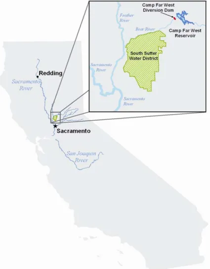
The District was formed in 1954 to develop, store, and distribute surface water. The District owns and operates Camp Far West Reservoir (Reservoir), Camp Far West Dam, and Camp Far West Diversion Dam (Diversion Dam); located on the Bear River within Placer, Nevada, and Yuba Counties. The District’s service area is located southwest of the Reservoir within Sutter and Placer Counties, south of the Bear River and east of the Feather River, and includes a gross area of approximately 66,000 acres. Figure 1 identifies the location of the District’s storage facility and service area within the Sacramento Valley.
Figure 1. South Sutter Water District Location Map.
Prior to the 1960s, groundwater was the main source of water supply in most parts of the North American Sub-basin, including the District’s service area. As a result, prior to the construction and subsequent enlargement of the Reservoir, groundwater levels underlying the District were steadily declining at an average rate of up to one and a half feet per year for approximately 50 years (Luhdorff and Scalmanini, 2009).
The development of the Reservoir resulted in an efficient conjunctive use project, which has operated successfully for the last 50 years. Currently, the District supplies surface water to approximately 59,000 acres within its service area. Landowners receive a supplemental surface water supply; thus reducing the amount of groundwater pumped in order to meet crop irrigation requirements. Results of monitoring documented in
groundwater basin reports identify that the District is a successful conjunctive use project and indicate that the District may be well situated to participate in water transfers through greater exercise of the groundwater basin (DWR, 1997).
Groundwater
As previously identified, prior to the construction of the Reservoir, the underlying groundwater basin within the District was declining. DWR began monitoring the groundwater elevations within the basin in the late 1930s to determine the extent of overdraft occurring. Following the formation of the District and subsequent construction of the Reservoir, additional monitoring was performed at production wells to monitor groundwater levels and groundwater quality. The District’s delivery of surface water and resulting in-lieu recharge of the underlying groundwater basin successfully restored groundwater elevations to stable levels with no indication of groundwater overdraft (Luhdorff and Scalmanini, 2009).
Surface Water
As part of the development of the Reservoir, the District applied for post-1914 appropriative water rights for the storage and direct diversion of water from the Bear River. The District also holds post-1914 appropriative water rights for several small streams within the District’s service area. The water made available for the 2008 Pilot Water Transfer was petitioned under the District’s post-1914 consumptive appropriative License 11118 (Application 14804). The District’s water right License 11118 is for direct diversion of 330 cfs from May 1 through September 1, and storage of 58,370 acre-feet from October 1 through June 30 from the Bear River. Due to the quantity proposed to be transferred under the 2008 Pilot Water Transfer, it was only necessary to make temporary changes to License 11118. No changes were petitioned for the remaining water right licenses held by the District.
Conjunctive Use
As previously identified, the District owns and operates the Reservoir in order to provide a supplemental surface water supply to landowners within the District’s service area. Landowners receive approximately one-third of their irrigation season water supply needs from the District’s surface water deliveries. Prior to the irrigation season, the District allocates a surface water supply based on forecasted reservoir storage, including
forecasted inflow and acreage identified by landowners seeking surface water deliveries in that given year. Landowners receive their allocation, acre-feet per acre, on a pattern dictated by crop irrigation need and conveyance canal capacity limitations.
Individual landowner groundwater pumping is used to meet the remainder of the crop irrigation requirement, which equates to approximately two-thirds of the water demand unmet by the District’s surface water deliveries. The District does not own or operate any groundwater production wells. Therefore, any additional increment of groundwater is pumped by a landowner to meet crop irrigation demand regardless of the District’s participation in a water transfer.
In the mid to late 2000s, record rice prices resulted in more acreage within the District’s service area being planted to rice production. This factor, coupled with the recent years’ dry hydrologic conditions, has resulted in a greater dependence on the groundwater basin. The quantity of groundwater pumped by individual landowners is not metered by the District; however, based on an estimate of acreage planted within the District and the cropping pattern, the District estimates that within recent years, groundwater pumping has been within the range of 150,000 acre-feet to 170,000 acre-feet.
2008 PILOT WATER TRANSFER
The District’s participation in the 2008 Pilot Water Transfer was the result of the
increased costs associated with regulatory processes and operations. In order to address the local issues associated with water transfers and any potential effects due to additional groundwater pumping, the District held a public meeting to inform individual landowners and receive input relative to the water transfer. At this public meeting, comments from landowners were addressed, including increased pumping costs and the potential for increased costs for surface water deliveries. It was estimated that the potential reduction in surface water deliveries was equivalent to approximately 0.1 acre-feet per acre and would be offset by an increase in the quantity of groundwater pumped by each individual landowner. This relatively small increase in pumping head and associated costs, as compared to the relatively large increase in surface water delivery rates proposed to be charged to landowners if the District did not participate in the water transfer, resulted in landowner approval and the unanimous approval by the Board of Directors to participate in the 2008 Pilot Water Transfer. The following section identifies the regulatory
approvals necessary to affect the 2008 Pilot Water Transfer. Regulatory Approval
In order to execute a temporary water transfer within California based on post–1914 appropriative water rights, a water right holder is required to petition and obtain the approval of the State Water Resources Control Board, Division of Water Rights
(Division). As part of the Petition process, a water right holder also has to provide public notice and respond to protests relative to a proposed water transfer. In addition, the water right holder is required to coordinate with the Department of Fish and Game (DFG) and the appropriate Regional Water Quality Control Board (RWQCB) to ensure that the proposed transfer does not unreasonably affect fish and wildlife or injure other downstream water right holders. For water transfers that utilize SWP facilities, the approval and execution of a Storage and Conveyance Agreement with the Department of Water Resources is also necessary.
State Water Resources Control Board. Pursuant to California water right law, an
individual water right holder can petition the Division to temporarily change the point of diversion, point of rediversion, place of use, or purposes of use in order to temporarily transfer water given the following conditions:
1. Transferrable quantity is limited to the amount of water that would have been consumptively used or stored in absence of the transfer,
2. The proposed transfer does not injure any legal user of the water, and 3. The proposed transfer would not unreasonably affect fish, wildlife, or other
instream beneficial uses. (Thomson and Reuters/West, 2009)
The District filed a Petition for Temporary Change to change the point of rediversion, place of use, and purpose of use under License 11118 to transfer up to 10,000 acre-feet of stored water from the Reservoir to the aforementioned SWCs. Following the Division’s review of the Petition, including publication and appropriate public comment period as identified in California Water Code §1726, the Division approved the temporary water transfer by issuing a water right Order. No protests were received relative to the
District’s Petition for Temporary Change. The water right Order authorized the transfer of up to 10,000 acre-feet of water, at a rate not to exceed approximately 120 cfs, from the Reservoir to participating SWCs.
Department of Fish and Game. DFG received a copy of the District’s petition package at the time it was filed with the Division. The package included information relative to the assessment of the potential effects of the proposed water transfer. In addition, District staff discussed the proposed water transfer with DFG in order to assess the potential effects of the increased releases from the Reservoir relative to fish and wildlife. Of particular importance, was the concern of potentially attracting anadromous fish into the Bear River, due to increased flow rates. Due to the relatively warm temperatures present within the Bear River during the period of the proposed water transfer, it has been
referred to as a hostile environment for anadromous fish species. Through a comparative analysis of projected flows within the Bear River and the Feather River, it was
determined that the increase in Bear River flows as a result of the transfer would be less than 5% percent of the anticipated Feather River flows. As a result, a biologist
determined that this relatively small increase in flows would not attract anadromous fish into the Bear River. In addition, due to the timing of the water transfer, July through September, the primary fish species of concern would not be present within the Feather River. Therefore, it was determined that the transfer would have a less than significant effect on fish species.
Regional Water Quality Control Board. District staff advised the Central Valley
RWQCB of the proposed water transfer to identify and address potential effects to water quality within the Bear River or the Feather River. Based on these discussions, the increase in flows within the Bear River was believed to improve water quality within the Bear River, and potentially the Feather River. The main area of concern raised by the Central Valley RWQCB was relative to tailwater effects to water quality. No change in cropping pattern was proposed by the District or its landowners. District staff identified
that the District and its landowners operate to minimize the quantity of tailwater leaving the District’s service area. Following these discussions, it was determined there would be no change in operations and no detrimental effect on water quality within the Bear River and Feather River.
Department of Water Resources. In order for the transfer water to be conveyed through SWP facilities, each buyer and the District entered into Storage and Conveyance
Agreements with DWR. The 2008 Pilot Water Transfer proposed to release water from the Reservoir for delivery to the SWCs at the Diversion Dam. Water made available pursuant to the 2008 Pilot Water Transfer, that otherwise would have been delivered to landowners, would need to be made up with groundwater pumping by individual
landowners. As part of the Storage and Conveyance Agreement negotiation process for the 2008 Pilot Water Transfer, and as further described below, the District and DWR worked cooperatively to modify the existing groundwater monitoring well network to spatially distribute monitoring wells within the District. DWR and the District developed a Groundwater and Surface Water Monitoring Program and a Third-Party Impacts Action Plan, as required pursuant to the Storage and Conveyance Agreement. The District, DWR, and the SWCs executed individual Storage and Conveyance Agreements for the 2008 Pilot Water Transfer on August 15, 2008.
Classification of the 2008 Pilot Water Transfer
A primary complication to the negotiation process of the 2008 Pilot Water Transfer was the transfer’s definition. The proposed transfer did not follow the general guidelines identified for either a groundwater substitution or reservoir release type transfer. The following section defines the two types of transfers and the considerations involved in classifying the 2008 Pilot Water Transfer as a combination of the two.
Groundwater substitution transfers involve the water transfer participant pumping groundwater to meet crop irrigation requirements in lieu of diverting surface water. Specific guidelines for groundwater substitution transfers are followed, including criteria to determine the eligibility of groundwater wells for participation in this type of transfer. Specific restriction for wells within one mile and two miles of a river are applied based on a review of the groundwater well completion record. Typically, wells within a participating entity are designated to participate in a groundwater substitution transfer; and the quantity transferred is measured at each groundwater well. The quantity of groundwater considered as transferred is the quantity pumped, less a pre-determined historical base quantity, if applicable.
Reservoir release type transfers involve the release of water from storage. The volume of water is normally measured at a point downstream of the reservoir where other required releases are measured, such as the instream flow requirements. The volume of stored water considered as transferred is the volume above a historical baseline, which includes the minimum release requirements.
The District’s 2008 Pilot Water Transfer proposed to release water from the Reservoir; and thence, the Diversion Dam where it would be measured. This resulted in a reduced surface water allocation to landowners; and therefore, the quantity of water that otherwise
would have been delivered to landowners was to be made up by individual landowner groundwater pumping. Approximately 150 groundwater production wells have been historically monitored by DWR, the majority of which were installed in the 1920s-1930s. The total number of groundwater production wells within the District’s service area are unknown; however, District staff approximates that there may be as many as 400 groundwater production wells within the District’s service area. Due to the time period of construction of these wells, well construction information is not available for a large percentage of groundwater production wells. The lack of information regarding the location and construction of groundwater wells within the District resulted in a pilot transfer approach and classification of the 2008 Pilot Water Transfer as a hybrid type transfer.
Available Water for the 2008 Pilot Water Transfer
Through the negotiation process for the 2008 Pilot Water Transfer, DWR expressed concern as to whether the full amount of water proposed to be released from the District’s Reservoir would be physically available for delivery to the SWCs through SWP facilities. In groundwater substitution transfers, a complication in the determination of the water made available is the hydrologic connectivity of water sources. The principle concern is that water pumped and made available for transfer induces recharge from hydrologically connected surface water stream sources, shifting the water physically made available from one source to another instead of providing additional water supplies to the proposed buyer. This has the potential to affect the water that would have been available to the other SWP and Central Valley Project (CVP) absent the water transfer.
Prior to 2008, DWR credited groundwater substitution transfers on a one-to-one basis, meaning that the amount of water pumped was equivalent to the amount of water to be transferred. During the 2008 negotiations, DWR identified that groundwater substitution transfers would no longer be credited on a one-to-one basis. Research, analysis, and data relative to the surface and groundwater interaction were, and continue to be, limited. In order to affect groundwater substitution type transfers in 2008, an assumed depletion loss was proposed to address this concern relative to the potential effects to the SWP and CVP.
The absence of flow measurement devices at groundwater pumps within the District, and the limited access to well completion and historic pumping records, further complicated the negotiation process and determination of the potential effects to the groundwater basin. Therefore, additional research and negotiations were conducted in assigning a depletion loss value to the 2008 Pilot Water Transfer. A historic analysis of monitoring wells located within the District indicates that in almost every year, the groundwater basin is recharged during the subsequent winter period. Both parties agreed that the precise depletion loss value was not known; however based on modeling conducted for the Sacramento Valley Regional Water Management Plan and an analysis of historic groundwater response to water demand within the District, a 6% depletion loss was agreed to. The depletion loss was shared equally between the buyers (3%) and seller (3%).
2008 Pilot Water Transfer Surface Water Releases
The District released water from the Reservoir, thence its Diversion Dam through dedicated water transfer weirs. The water elevation at the Diversion Dam pool was measured by a continuous water level recorder. The District fabricated and installed weir plates in order to calculate the amount of water released based on a standard weir
equation. The Diversion Dam configuration during the 2008 Pilot Water Transfer is shown in Figure 2.
Figure 2. 2008 Pilot Water Transfer Weir Configuration. Groundwater and Surface Water Monitoring and Mitigation Plan
Due to the increased groundwater pumping by individual landowners within the District, and the potential for third-party impacts, the District and DWR reviewed and updated the groundwater level monitoring network within the District’s service area and established a Groundwater and Surface Water Monitoring and Mitigation Plan. Groundwater elevation and groundwater quality field parameters, including specific conductance, pH, and
temperature, were collected from groundwater production wells identified within the monitoring well network. DWR also monitors additional wells within and near the District’s service area for other purposes on a semi-annual and monthly basis. Overall, data from 85 wells relating to groundwater elevations and groundwater quality were collected and analyzed.
Streamflow was measured at four locations, including the Camp Far West Diversion Dam (CFW DD), USGS (Gage 11423800) – Bear River Fish Release below Camp Far West Reservoir, USGS (Gage 11424000) – Bear River near Wheatland, and the DWR – Gage (BPG) Bear River at Pleasant Grove Road in order to verify the surface water releases from the Diversion Dam.
2008 Pilot Water Transfer Results
The 2008 Pilot Water Transfer volume was initially estimated at 10,000 acre feet. Due to dry hydrologic conditions and the uncertainty relative to the forecasted inflow to the
Reservoir, ultimately, 6,909 AF (7,123 AF total released minus a 3% depletion loss of 214 AF) was transferred. Table 2 identifies the quantity delivered pursuant to the transfer to each participating SWC.
Table 2. Quantity delivered pursuant to the 2008 Pilot Water Transfer to each participating State Water Contractor.
State Water Contractor Percent Allocated
(%)
Approximate Quantity Delivered 3 (Acre-feet)
Antelope Valley East Kern Water Agency 7.02 485
Dudley Ridge Water District 1.41 97
Kern County Water Agency 14.22 983
Metropolitan Water District of Southern California
68.0 4,698 Napa County Flood Control and Water
Conservation District
1.87 129
Palmdale Water District 3.40 235
San Bernardino Valley Municipal Water District 3.40 235 Tulare Lake Basin Water Storage District 0.68 47
Total Quantity Delivered 6,909
Following the 2008 Pilot Water Transfer, DWR, and the District worked cooperatively to draft the South Sutter Water District 2008 Pilot Water Transfer Groundwater and Surface Water Monitoring Summary (Joint Report) summarizing the monitoring performed during the 2008 Pilot Water Transfer and any potential effects attributable to the water transfer. The reduction in surface water deliveries to the District’s landowners as a result of the 2008 Pilot Water Transfer corresponds to an approximate 4% increase in the total estimated groundwater pumped within the District’s service area during the 2008 irrigation season (DWR and South Sutter Water District, 2010).
As previously identified, groundwater data from 85 wells within and near the District were collected and analyzed. Figure 3 identifies the location of groundwater wells monitored within and near the District. The wells are identified by monitoring agency and include groundwater levels and groundwater quality data collected during the 2008 Pilot Water Transfer period within the monitoring network for the 2008 Pilot Water Transfer and additional data collected from groundwater wells within and near the District.
3
Approximate quantity delivered pursuant to the transfer is at the point of delivery, Camp Far West Diversion Dam; and therefore, does not include the SWCs assumed portion of the depletion loss (3%) or transportation losses from the point of delivery to the SWCs diversion facilities.
Figure 3. Location of Groundwater Monitoring Wells within South Sutter Water District. Figure 3 identifies that the majority of the monitoring wells within the District are also production wells. Four multi-completion dedicated groundwater monitoring wells, including an extensiometer, are also located within and near the District, BR-1, AB-1, AB-2, and the Sutter Extensiometer. Groundwater quality data was recorded at four groundwater production wells during the transfer period.
Figure 4. Representative Groundwater Hydrographs within and near South Sutter Water District.
Figure 4 identifies the groundwater hydrographs of representative wells identified in Figure 3 for the period of 1970-2008. As identified in the groundwater hydrographs, the basin historically has responded to dry hydrologic periods with declines to the
groundwater basin. The 1977-1979 drought is identified by declines and subsequent recoveries to groundwater elevations. As shown in Figure 4, groundwater elevations during the period of the 2008 Pilot Water Transfer are within historical groundwater levels observed. The dry hydrologic conditions, coupled with the increased acreage planted to rice production, resulted in an increased dependence on the groundwater basin. It was difficult, given the relatively small increase in groundwater pumping, to
differentiate between the potential effects due to the 2008 Pilot Water Transfer from other factors. However, the results of the draft Joint Report indicate that overall, groundwater conditions underlying the District in 2008 remained consistent with
historical observations and the basin did not experience abrupt changes, which may have been attributable to the 2008 Pilot Water Transfer (DWR and South Sutter Water District, 2010). All groundwater monitoring wells within the District recovered to pre-transfer (April, 2008) groundwater elevations by March, 2009. No third party impacts as a result of the 2008 Pilot Water Transfer were identified.
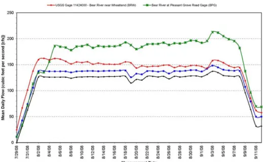
Surface water monitoring performed during the 2008 Pilot Water Transfer downstream of the point of delivery further verified the quantity of water released from the Reservoir and Diversion Dam. Figure 5 identifies the location of the gage stations.
Figure 5. Bear River Gage Stations.
The first USGS Gage downstream of the Diversion Dam, USGS Gage 11423800, measures the dedicated fish release by the District for instream flow obligations. This quantity, in addition to the quantity released over the Diversion Dam pursuant to the 2008 Pilot Water Transfer and the District’s other existing agreement, (Bay-Delta Settlement Agreement, BDSA) represents the total quantity of water released into the Bear River by the District. Figure 6 identifies the rate of release from the District’s Diversion Dam and the flow rates at USGS Gage 11424000 and DWR Gage BPG.
Figure 6. Surface Water Monitoring Performed Pursuant to the 2008 Pilot Water Transfer (Source: DWR and South Sutter Water District, 2010).
As identified in Figure 6, the total releases at the Diversion Dam, plus the fish release, are accounted for at both downstream gages. The daily variations in releases are a result of operational issues and considerations that are common to systems of this nature.
Protection of the Groundwater Resource
Following the 2008 Pilot Water Transfer, the District updated its Groundwater
Management Plan (GWMP). The protection of the underlying groundwater basin, and the assurance of a stable groundwater and surface water supply for District landowners, is a principal concern of the District. The update to the GWMP analyzes historic trends within the region and identifies the District’s Best Management Objectives (BMOs) for protection of the resource and the potential development of alternative water supplies for consideration in future water transfers.
BUILDING PARTNERSHIPS FOR FUTURE WATER TRANSFERS
Water transfers require a significant amount of coordinated planning and operations between a number of parties, including the buyer, seller, and regulatory agencies. The use of storage and conveyance facilities belonging to or operated by entities not directly involved in the buying or selling of water further complicates the accounting and
negotiation process. Therefore, the need for the development of a transparent and positive relationship between buyers, sellers, and regulatory agencies is essential to the success of executing a water transfer.
Following the 2008 Pilot Water Transfer and the development of a positive working relationship between the regulatory agencies and the District, the District negotiated and executed a contract for a 2009 water transfer to DWR’s 2009 Drought Water Bank, of which Metropolitan is the largest participant. The foundations built during the 2008 water transfer facilitated and expedited the 2009 water transfer negotiations and resulted in 10,000 acre-feet of water being transferred to agriculture and municipal water
purveyors with critical water supply needs. The District continues to monitor the
underlying groundwater basin to develop a better understanding of the groundwater basin response to withdrawals and in order to protect this valuable resource. The District will continue to review the opportunity for future water transfers to fulfill the financial obligation associated with infrastructure improvements, regulatory compliance, and overall operation costs.
CONCLUSIONS
The multiple forms of water transfers and their flexibility make water transfers a
promising water management tool. The benefits resulting from a water transfer can serve a multitude of purposes, including agriculture water supplies, municipal water supplies, and environmental beneficial uses. In addition, these partnerships provide economic benefits for funding infrastructure improvements. The flexibility associated with water transfers during drier hydrologic conditions, results in the movement of water supplies to meet the demand of a region whose local water supplies and reserves are limited for
numerous reasons. In this case study, the District and the SWCs, specifically Metropolitan, worked cooperatively to build the transparent and positive working relationship to successfully effect the 2008 Pilot Water Transfer. The complexities involved with water transfers due to legal, third party, and complex technical issues require strong partnerships to address and overcome the multitude of considerations for the success of future water transfers.
REFERENCES
Department of Water Resources, South Sutter Water District. Summary of South Sutter
Water District 2008 Pilot Water Transfer Groundwater and Surface Water Monitoring Summary. Sacramento, CA: 2010:1-16.
Department of Water Resources – Central District. Feasibility Report - American Basin
Conjunctive Use Project. Memorandum Report. Sacramento, CA: DWR Reprographics;
1997: 11-107.
Department of Water Resources. Groundwater Level Data for Well No. 12N05E6R001M.
http://www.water.ca.gov/waterdatalibrary/groundwater/hydrographs/report_html.cfm?We
llNumber=12N05E6R001M. Updated December 2009. Accessed January 13, 2010.
Luhdorff and Scalmanini. South Sutter Water District Groundwater Management Plan. Updated 2009. Sacramento, CA: 2009: 10-13.
Metropolitan Water District of Southern California. Conservation and More at a Glance.
http://www.mwdh2o.com/mwdh2o/pages/news/at_a_glance/Conservation.pdf . Updated
May, 2008. Accessed September 10, 2009.
Metropolitan Water District of Southern California. Profile – A summary of Delivery and
Distribution, Facilities and Equipment.
http://www.mwdh2o.com/mwdh2o/pages/news/at_a_glance/mwd_profile.pdf . Updated
October 2008. Accessed September 10, 2009.