E
nergy
''t!AIM!W185''
(u .-.)c.~RME
1055
(Rev.)
UNCLASSIFIED
r
UNCLASSI Fl ED
l18RARY COP
Y
@
RME-1055(Rev.)
GEOWGY AND MINERAWGY
UNITED STATES ATOMIC ENERGY COMMISSJON
AIRBORNE RADIOMETRIC SURVEY OF THE BROWNS PARK FORMATION, CARBON
COUNTY, WYOMING
By
Dan N. Magleby Neil S. Mallory
December 20, 1954
Denver Exploration Branch Division of Raw Materials Denver, Colorado
Technical Information Service Extension, Oak Ridge, Tenn.
Me~a State College libra,y Grand Junction, CO
LEGAL
NOTICE
_ _ _
_ __,
This report was prepared as an account of Government sponsored work. Neither the United States, nor the Commission, nor any person acting on behaU of the Commission: A. Makes any warranty or representation, e~ress or implied, with respect to the accuracy, completeness, or usefulness of the Information contained in this report, or that the use of any Information, apparatus, method, or process disclosed in this report may not Infringe privately owned rights; orB. Assumes any liabilities with respect to the use of, or for damages resulting from the use of any information, apparatus, method, or process disclosed In this report.
As used in the above, "person acting on behalf of the Commission" includes any em-ployee or contractor of the Commission to the extent that such emem-ployee or contractor
prepares, handles or distributes, or provides access to, any Information pursuant to his employment or contract with the Commission.
This report has been reproduced directly from the best available copy.
Printed in USA. Price 20 cents. Available from the Office of Technical Serv-ices, Department of Commerce, Washington 25, D. C.
-~
r
.J· OF THE BROWNS AIRBORNE RADIOMETRIC SURVEY PARK FORMATION CARBON COUNTY, WYOMING
CONTENTS
RME-1055
(Rev.) .ABSTRA.CT - - -4
INTRODUCTION - - -4
PHYSIOGRAPHY - - -4
Topography Vegetation Accessibility GEOIDGY - - - -Structure Stratigraphy Location of Anomalies5
AIRBORNE PROCEDURES - - - 8GROUND INVESTIGArION PROCEDURES - - - ~ - - - - 8 OTHER WORK IN THE AREA - - - 18 CONCLUSIONS AND RECOMMENDATIONS - - - -. - - - l.B REFERENCES - - - 19
ILLUSTRATIONS Table I Stratigraphic Sectton of.the Browns
Park Formation - - - 6 Table II Sua?ma.ry of Anomalies - - - 9
Plate 1 Airborne Located Anomalies, Carbon County,
Wyoming - - - 20
-3-AIRBORNE RADIOMETRIC SURVEY OF THE BROWNS PARK FORMATION
CARBON COUNTY> WYOMING ABSTRACT
RME-l0.55(Rev.)
A.~ airborne radioretric survey of the Browns Park formation (Tertiary) was conducted by the Atomic Energy Commission from September 19.53, to November 19.53, in the vicinity of Miller Hill and Baggs, Wyoming. Fifty-four anomalies were discovered. Assays from four of the anomalies indicate the possibility of commercial deposits of uranium.
INTRODUCTION
In the fall of 19.52 au. s. Geological Survey DC-3 aircraft,
equipped with scintillation counter, detected eleven areas of anoma-lous radioactivity in the Miller Hill area of t,.qoming. The anomalies, located in an algal limestone about 33.5 to 400 feet above the base
of the Browns Park formation, were checked and sampled by the
u. s.
Geological Survey at that time(l).L~tensive airborne reconnaissance of the area by the Atomic Energy Connnission started on September 10, 19.53, and was completed by November 1, 19.53. During this period 865 hours of flying were
logged and .54 areas of anomalous radioactivity were detected (Plate 1). The Browns Park formation in Carbon County, Wyoming, was covered
by airborne reconnaissance, and sore fiights were made over other formations which crop out within the area.
Neils. Mallory, geologist, and Jack Bethel, pilot, comprised the airborne crew. Dan N. Magleby was the ground reconnaissance
geologist; Jonathan P. Hadfield made detailed examination of the deposits.
PHYSIOORAPHY
TopographyThe Miller Hill area, spanning the continental divide, is a broad plateau with the principal drainage systems cutting deeply into the gently rolling surface. Elevation along the continental divide generally is above 8,000 feet; the drainage lines, however, lie about
6,500
feet along the southern edge and about 6,800 feetelsewhere. West of Baggs, Wyoming, is a small plateau with a poorly developed drainage pattern.
Vegetation
Vegetation is characterized by sagebrush and grass. Along the streams there are meadows with a few cottonwood trees. In the mountains southeast of Miller Hill there is an abundant growth of pine.
Accessibility
There are paved highways on the east and west sides of Miller Hill. Wyoming State Highway 330 goes north through Baggs, and
joins Uo S. Highway 30 twenty-six miles west of Rawlins, Wyoming.
In the Miller Hill area, and in the area l'rest of Baggs, there is a network of secondary roads suitable for travel by passenger car. A jeep can be driven to almost any part of the area. (Plate 1).
GEOI.OOY
The areas described in this report are on the eastern side of the Washakie Basin and on the divide between the La.ramie and the Washakie Basins. The Browns Park fomation (upper Tertiary) unconforma.bly overlies strata from Precambrian to Eocene age. Several anticlines and faults L"l the older formations are exposed wb:!re the Browns Park formation has been removed by erosion. In
some localities these faults cut the Browns Park formation. Stratigraphy
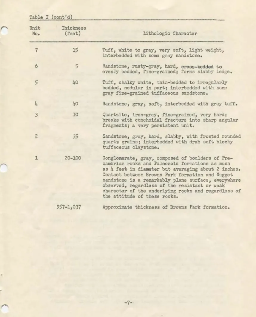
Inasmuch as most of the anomalies found during this survey are in the Brow=is Park formation, only this formation will be described. Table 1 is a stratigraphic section of the Browns Park adapted
from Uo
s.
Geological Survey circular 278 (1).Plate l indicates the areal extent of the Browns Park forma-tion and the locaforma-tion of the anomalies.
Location of Anomalies
The anomalies in algal limestone in the Browns Park formation are due to a carnotite-type mineral filling fractures in the upper few inches. Uranium has not been found in conmercial quantities
:L~ this lim:3stor.e.
Carnotite-type minerals are found also in the sandstones of the Browns Park formation. Insufficient work has been done on these sandstones, however, to accurately place all of them stratigraphically within the formation. The sandstones in the anomalous area are crossbedded and eitrer calcareous or ferruginous
-5-TABLE I
STRATIGRAPHIC SEX;TION OF BROWNS PARK FORMATION ON MIDDLEWOOD HILL (Units are numbered consecutively from oldest to youngest)
Unit
No.
15
13
12 11 10 9 8 Thickness (feet)500
100 1225
55
3050
10 Li~hologic CharacterSandstone, white to.light-gray, very tuffaceou.s, soft, .fine- to coarse-grained, evenly bedded, with many resistant liJ!:Gr layers that .form persistent ledges. Top of unit caps Middlewood Hill. Sandstone, 'White to gray, limy tuf.faceous interbedded with white, crystalline, nodular, sandy, tuf.fac_eous limestone.
Algal limestone marker bed, gray, hard, very
ragged and nodular on weathered surfaces, with
some tuffaceous sandy beds l to 2 feet thick in lower two-thirds; pseudo-oolitic in lower 2 feet, contains abundant vertical root tubes, some of which fluoresce brilliant yellow under ultra-violet light; top 6 feet contains masses and fracture .fillings or dark-gray to brown chalcedony and opal; chalcedony and limestone
both quite radioactive; unit is widely persistent throughout area and seems to have abundant algal growthso
Sandstone, gray, grac;ling'into sandy limestone, highJ3 nodular, weatberil'.lg into ragged porous ledges; ·has appearanGe of. l;)eing partly calcareous tu.fa.
Sandstone, gray, limy intergrading with gray sandy li.n2stone similar to overlying unit, but softer
in lower half, forms slope; about l .foot of dark-gray tu.ff
35
feet below top.Sandstone, gray, hard, very limy, weathering into ragged ledges. Uraniferous.
Sandstone, white to light-gray, soft, fine-grained, very tuf.f aceous, partly micaceous; many black
grains, very few red grains.
Sandstone, rusty-brown, ferruginous, soft, coarse-grained; contains small pebbles.
Table I ~ Unit No. t 7
-~
65
4
3 2 1 ,.
(cont'd) Thickness (feet)15
40
40
1035
20-100957-1,037
Lithologic CharacterTuff, white to gray, very soft, light weight,
interbedded with some gray sandstone.
Sa.'1.dstone, rusty-gray, hard, cross-bedded to
evenly bedded, fine-grained; forms slabby ledge. Tuff, chalky white, thi.."1.-bedded to irregularly bedded, nodular :L"l part; interbedded with some
gray fine-grained t'..lffaceous sandst.one.
Sandstcne, gray, soft, inter'bedded with gray tuff. Quartzite, iron-gray, fine-grai.Ii.ed, very hard; breaks with conchoidal fracture into sharp angular
fragments; a very persistent unit.
Sandstone, gray, hard, slabby, with frosted rounded quartz grains; interbedded with drab soft, blocky tuffaceous claystor.e.
Conglomerate, gray, composed of boulders of
Pre-cambriar.. rocks and Paleozoic formations as much as
4
feet in diameter but averaging about 2 inches. Contact between Browns Park f-0rmation and Nugget sandstone is a remarkably plane surf ace, everywhere obser-..red, regardless of the resistant or weakcharacter of the underlying rocks and regardless of t~e attitude of these rocks.
Approximate thickness of Browns Park formation.
-7-or both. The radiometric readings are generally higher where iron or mang;inese dendrites occur in the bedding planes and tension
crackso Four of the anomalies -- 30,
45, 49,
and51
--
probably have conmercial possibilities.AIRBORNE PROOEDURES
The flying was done in a
PA
18, 135
horsepower Super Cubhigh-wing monoplane equipped with a Mark VI airborne scintillometer. Since the objective of the survey was to prov.i.de complete coverage of the area underlain by the Browns Park formation, both rim and grid coverage were employed; special effort was made to fly all rim outcrops. At first, rim flying was concentrated on the algal limestone, but as concentrations of uranium minerals were found in the sandstone, a special effort was made to include all
small hills and erosional cuts where the sandstone might be
close to the surface.
Control for the survey was maintained by the use of
u.
S. Geological Survey topographic maps, a photo mosaic of the area, and the geological map of Carbon County(2).
In flying to and from the area other formations were checked and it was noted that the Wasatch formation near Miller Hill registered a high radiometric background.GROUND INVESTIGATIONS PROCEDURES
All anomalies discovered by the airborne radiomatric survey
were investigated on the ground. Table II summarizes ~ormation concerning the anomalies; the locations of the anomalies are shown on Plate 1.
The most promising uranium showing in the Miller Hill area is at Anomaly 30 on Ketchum Buttes (Table II).
An unidentified uranium mineral was observed as thin coatings along bedding planes in a band 12 feet down from the top of a 60-foot sandstone escarpment at the Avon Brock prospect (Plate I).
From the standpoint 0£ potential production, an area of low-to 11)3dium-grade radioactive material in parts of sections
4 and
5,
T. 12 N., R. 92 W. about 7 miles west of Baggs, Wyoming (Plate 1), appears to be the most important. There are uranium minerals inseveral exploratory pits in a friable fine- to medium-grained, variegated, limonitic and hematitic sandstone. Two uranium minerals are believed to be present: carnotite, and a green and pale yellow-green material that fluoresces bright green (probably meta-autunite and some schroeckingerite). The material contains
• (I
)
)
)
TABLE II SUMMARY OF ANOMALIES c• Anomaly SampleNumber Number
%U30a
Radioactivity Rock Description1
24988
0.02
Surface -80
cps. Light brown, very fine-grained, argillaceous Pit2
1 -175
cps. sandstone. North Park formation.2
24989
0.03
Surface -175
cps. Fine- to coarse-grained, calcareous, limonitic sandstone. Also manganese staining. North Park~ formation.
I
3
24984
Trace Surface -120
cps. Grat'-green, very fine-grained, calcareous sand-Pit2'
-
200
cps. stone f'loat.4
24985
0.01
Surface -150
cps. Fine-grained calcareous sandstone and brown to black chalcedony. Possible uranium minerals visible.5
24986
0.04
Surface-
900
cps. Brown and black chalcedony in limestone.6
24990
Trace Surface- 120
cps. Fine-grained, dark grey sandstone and sandy limestone.7
24991
Trace Surface - 90 cps. Soil and alluvium (calcareous).24992
0.02
Pit5
1 -150
cps.8
24995
0.02
Surface -120
cps. Grq, arenaceous float, (limestone).TABLE II (Cont'd)
Anoma~ Sample
Number Number
%U3os
Radioactivity Rock DescriptionI
9
24994
0.01 Surface - 200 cps. Dark brown chalcedony. Vugs filled with limonite. Pit 6" - 27, cps •.
10
24993
0.01 Surfac~ - 150 cps. Dark brown and black chalcedony in ,sandy lime.stone.Pit 1}1 - count decreased
•
.Dark brown and black chalcedonytn
sandylimes.tone. -·
b
11 ·24996 0.02 S~face -400
.
~ps,l
..
~.
Vugs _in the cl'talc.e4ony·
.
aie
co_~ted with limonita.···.:: . ' .
12 2499.7 Trace Surf ace - ·80 cps_. :.
P:lt
2t'
·
-
100 ·cps.Gra1 ,cind br.own, f~e"".graµied . sandst.one float.!.
13 2_4998 0~007 · Surface - JOO cps. Gray·and brown calcareous .sandstone with manganese Pit
3'
- 500
cps. dendrites -and caliche.24999 0.016 Surface -
.
250 cps. Ar~naceous limestone with in9luslona ·of limonite~· stained sand.
15 25000, 0.031 · Surface
- 400
.cps. Ax:e~aceous limestone with,:·1.n~iusions of limon;lte-. -sta;lned sand.-.•
16 ·25362. 0 .• 045 Surface - 200.cps. Erosional renmants .of ·chaJ:cedony'boulders.
.·
.
:·:,·
...
17 25363 o·.02 Surface - .300 cps. Dark brown chal-0edony that
has
yugs filled with limonite .•)
Anomaly Sample
Number Number %U308
18 25364 0.009 19 25365 0.011 20 25366 0.011 I
t:::
I 21 25367 0.008 22 25368 0.008 23 25369 0.013 24 25 25370 0.012 26 25430 Trace 25431 Trace)
I ,,r I)
TABLE II (Cont'd)Radioactivity Rock Description
Surface - 120 cps. Red, brown and black chalcedony float.
Surface - 200 cps. Red, brown and black chalcedony in an arenaceous limestone.
Surface - 120 cps. GraY arenaceous limestone float.
Surface - 70 cps. Gray and brown, fine- to medium-grained sandstone Pit 11• - 110 cps. Caliche on fractures.
Surface - 120 cps. Gr~-green, fine-grained calcareous sandstone. Pit
1t•
- 200 cps.Surface - 100 cps. Crystalline, arenaceous linestone with manganese Pit 2}1 - 325 cps. and limonite staining.
Surface - 100 cps. Crystalline, arenaceous limestone with manganese Pit 2!' - 250 cps. and limonite staining.
Surface - 250 cps. Pit
3' -
275 cps.Fine-grained, arenaceous, limonite sandstone. Surface - 200 cps. Soil containing blue-green shale and fine-grained, Pit 2}1 - 275 cps. brown sandstone float.
Pit
3'
- 400 cps. Pit3'
- 500 cps.Anomaly Nwnber
27
28
29 3031
32
33 Sample Number25371
25372
25373
25374
25432
25433
25434
25435
25436
25437
25438
25439%U306
0.007
0.035
Trace0.007
0.10
0.30
0.80
0.02
0.03
0.010.01
0.06 TABLE II (Cont'd) Radioactivity Surface -550
cps. Pit3' - 800
cps. Surface - 90 cps. Pitli'
- 130
cps. Surface -400
cps. Pit6
11 -450
cps. Surface -1200
cps. Pit 21 -1500
cps. Pit3' -
3500
cps. Pit 31 - 2500 cps. Surface - 120 cps. Pit4'
-
250
cps. Surface -450
cps. Pit4' -
lOOO cps. Surface -450
cps.4' ·
auger hole -o.2
mr./br.
slightde-crease with depth. Surface - 1200 cps. Pit
4' -
800
cps.Rock Description
Soil with blue-green shale and fine-grained sand-stone float.
Light to dark gray, calcareous shale. North Park formation.
Crystalline limestone, sandy in part, and chalcedony. Varies from an arenaceous crystalline limestone to a very fine-grained, limonitic and hematitic semi-con-solidated sandstone. Visible radioactive min3rals, probably carnotite and schroeckingerite.
Sandy shale.
Very fine-grained, gray-green sandston:3 containing clay galls.
..
)
Anomaly Sample
Number Number
%U30a
34
25440
Trace 3525441
0.01
25442
0.03
25443
0.01 I ~ I36
25444
37
25445
0.02
38
25446
0.01
3925447
o.oo6
40
25448
0.006
41
25449
0.01
)
.
.,.
.
)
TABLE II (Cont'd)Radioactivitz Rock DescriEtion
Surface - 350 cps. Dark brown chalcedony.
Surface~
2000
cps. Thin-bedded, fine-grained, dark gray quartzite.Pit
2f
1 -3500
cps. Possible uranium minerals.Count decreased be-low this level.
Surface -
200
cps.Pit
2'
-
325
cps •.Fine-grained, calcareous sandstone.
Surface -
250
cps. Fine-grained, calcareous sandstone.Pit
2
1 -275
cps.Surface -
100
cps. Dark brown and black chalcedony.Pit
6"
-
200
cps.Surface -
125
cps. Fine-grained gr83'-green, limonitic sandstone,Pit 21 -
225
cps. semi-consolidated.Sur.face -
550
cps. Fine-grained, gra_y sandstone! Caliche inPit
2
1 -·1150
cps. places.Surface
500
to Grey, yellow, green, fine-grained limonite and1000
cps. • hematite stained. Highest radioactivity con-Pitli' -
JOOO cps. nected with greatest concentration of ironTABIE II (C-Ont 'd)
Anomaly Sample
Number Number %U30s Radioactivity Rock Description
42 25450 0.02 Surface - 2000 cps. Fine-grained, variegated, semi-consolidatod sand-(extends over an area stone. Caliche on bedding. Faint yellow streaks of 50 sq. ft.) (1-3") in sandstone probably a uranium mineral. Pit 2' - 4200 cps.
Surface - 2000 cpso Very fine-grained, gray and yellow, calcareous
I sandstone, argillaceous in parto Faint yellow
t:
streaks in sandstone probably a uranium miner~.I
43
Surface - 1200 cps. Fina-grained, friable, gray-green sandstone. Pit 2' - 2500 cps. Little limonite staining.Surface - 2000 cps. Fine-grained.§ friable, green-yellow and gray sand-Pit 2' - 3200 cps. otone. Trace of a yellow uraniu.m mineral
dissemi-nated in sandstone in thin streaks.
45 33051
0.93
:Vax. surface - 2000 Fine-grained, friable, green-gray ~andstone.cps. Pit 21 .3000..~. . Limonite and manganese staining • Some sooty carbon
(count d9creased me.terial is present. False bedding (cross-bedding) slight~ below 1 ft. st.rikes 80° E and dips lio0 N. Yellow uranium
level). mi.~ral disseiWla. t..ed in thin. bands in sandstone. 46
33052
0.06 Surface - 500 cps. Limon.i.tic, fine- and angulclr-grained, fr5.ablesand-Pit 2' - 2500 cps. atone. Thin lenses (~1") of medium- to coarse-grained sandstone in the fine-grained sandstone.
)
•
G:
l Anoma.l.3 Number47
48
49
50
1 h Sample Number33053
33054
33055
33056
0.02
0.02
0.29
)
)
TABIE II (Cont'd) Radioactivit,; ~ . surface-600
cps. Highest count of2500
cps.6"
below surface. Count decreased be-low 6" • Surface 1000 cps. Highest radiom:ltric reading is6
11 below surface - 3000 cps. and 1mr/hr.
Count decreased below 611 level. Rock DescriptionFine-grained, friable, white, orange and gray cal-careous sandstone.
Fine- to medium- and angular-grain9d, limonitic sandstone. Outcrop of cross bedding strikes N.
75°
W. and dips 30° N.Surface - 1000 cps. Friable, limonitic, fine-graf:hed sandstone. Outcrop Max. count ~n pit is of cross bedding strikes N. 350
w.
1 dips
25°
N. Minor611 below surf ace - amounts of a yellow uranium mineral disseminated in
2700 cps. and 1.2
mr/hr.
sandstone adjacent to bedding. Surface - 1000 cps.Max.
in"l' pit-3000
cps. and 1.2 mr/hr Surface - 120 cps. In pit 6° deep -300 cpsFriable, fine-grained, limonitic sandstone. Minor amounts of a yellow uranium mineral disseminated in
the sandstone and directly associated with the limonite.
Anomaly Number
52
Sample Number.3.3057
33058
330590.08
TABLE II (Cont'd) Radioactivity Sur.f'ace - 1200 cp~.In pit highest
ra~o-activity is
6
11 belowsurface - 1500 cps.
Pit on north side
of hillo Surface~ 1000 cps. Pit 21 -5000
cps.
an
_
d
3mr/br
Max.
surface - 1100 cps. _Pit 21 - 2000 cps. Rock Descrip~i6nHematitic and limonitic, fine- to medium-grained
friable sapdstone o Minor amoUJ1ts of a yellow µr.anium
mineral disseminated in sandstohe and closely
aasoci-a ted with hematite. ··
Fer:niginous, fine-grained, friable sandstoneo High
count in a 2 to
6tt
band of sandstone that hasdissem-inated in it a yellow uranium mineral, probabl,y c-arno-tite.
Unconsolidated., fine-grained., gray. and brown sandstone.
Heavy caliche cover on bedding.
53
This·entire butte registers radioactivity 2 to 10 times background. Pits were dug in areas of highsurface radioactivity.
33060
0.01
East end of butteSurface - 800 cps.·
Max.
in pit 2}' -2500 cps-. Southeast end of butte. Surface -800 cps. Pit 21 -1100 cps.Hard, thin-bedded., gray., fine- to medium-grained limy
sandstone. Limonite stain is host to highest radio-activity.
Fine-grained., green-gray., limonitic sandstoneo A
)
I ~ I\
.
r -Anomaly Number Sample. Number33061
0.02••
·-
.
,. . TABJ..E II (Cont Id) Radioactivity . t . 'South .end.of butte.
Surface -- 800 cps.
Pit 41 - 4000 cps.
•
Rock .!)ascription
Fine- to medium-grained, poorly sorted, green-yellow, friable sandstone. Limonite staining· in part •
Radioactivity-ioo to Fine-grained, orange and gray friable sandstone. 300 cps. covers· the
/
as mu.ch as
9o03
percent U305• In many places the high radioactivity is associated with heavy limonite and hematite stains that obscure the color of the uranium minerals.OTHER WORK IN. THE
AREA
The
u.
s.
Geological Survey in November,1953
made another radiometric survey and discovered165
anomalies(3,
4,
5,
6
and7)•
Subsequent to the publication of the anomaly locations.f private
operators staked claims in the area west
ot
Baggs, Wyoming, andin the spring of
1954
carried Qn stripping and trenching which un•covered some showings of uranium..
CONCLUSIONS AND REX':OMMENDAT
rom
As a result of the Atomic Eilergy- Commission
survet,
54
anomalieswere located, four of which indicate uraniwn deposits
ot
possibleeconomic importance; the deposit at ItetchUlll Buttes and. three
anoma-lies in the area west of Baggs»
Wyoming, are
the aost promising.The deposits from which assays of over 0.20 percent urani~ were
ob-tained are found in a non-ealcareous sandstone .. ~ .carnotite•
type mineral deposits in limestone do not seem to. contain sufficient
uranium to be considered. ore grade.
In· view of the occurrence ot uranium millerals in the Browns
Park formation in the Miller Hill and Baggs area,:an
airborne
radiometric survey of all outel"Qps in this torma'iion in the
Washakie Basin may be profitable.
The
high background of the Wasatch formation suggests asimilar
survey on its.'.outerops..
"'
REFERENC.ES
1. U>ve, Jo
D.,
Preliminary Report of Uranium Deposits in theMiller Hill Area, Carbon County, Wyoming: U. S. Geolo
Survey Circ.
278, 1953.
2. Weitz, J. L. and love, J.
D.,
Geological Map of Carbon County, Wyoming: Wyo. Geol. Survey,1952
•
3.
Henderson, J.K.,
Airborne Radioactivity Survey of Parts ofBaggs SW and SE Qu.adrangl.es, Carbon and Sweetwater Counties,
Wyoming:
u. s.
Geol. Survey,TEM-743,
1954.
4.
Henderson, J.K.,
Airborne Radioactivity Survey of Parts ofSand Creek
SW
and Sand Creek SE Quadrangles, SweetwaterCounty, Wyominga
u.
S.
Geol. Survey,TEM-744,
1
954.
5.
Henderson, JoK.,
Airborne Radioactivity Survey or Parts ofSavery SE and Savery SW Quadrangles, Carbon County, Wyoming:
Uo S. Geol. Survey,
TEM-745, 1954.
6. Henderson, J.
K.,
AirQorne Radioactivity Survey of Parts ofSaratoga NW, Carbon County, Wyoming:
u. s.
Geol.Survey,-TEM-746, 1954.
7.
Henderson, J.K.,
Airborne Radioactivity Survey of Parts orSavery NW and Savery NE Quadrangles, Carbon County,
Wyomingt Uo So Geolo Survey,