Defining an Integrated Interdisciplinary Approach: I-WATER
Fellows Address Challenges Confronting Freshwater Resources
Erick Carlson, Dylan Harrison-Atlas, Laurel Lynch, Isaac Medina, David Martin, Alex Maas, Grace Lloyd Miner, Joel Sholtes, Nick SutfinI-WATER: Integrated Water Atmosphere Ecosystems Education and Research Program, Colorado State University
The scientists and their disciplines
During the 2012 Fall semester, Colorado State University I-WATER fellows were charged with the task of examining “Integration at the Interfaces” of the I-WATER themes. The I-WATER program contains three major research themes – each fellow is seated within one of these three research themes (Fig. 1):
§ Theme I: Hydrologic, Atmospheric, and Ecologic systems (HAE) § Theme II: Hydrologic, Ecologic, and Socio-economic systems (HES) § Theme III: Hydrologic, Atmospheric, and Socio-economic systems (HAS) § Theme IV: I-WATER Integration and Synthesis
Figure 1. Schematic Diagram of I-WATER Research Themes
Specifically, I-WATER research teams were tasked with producing assessments to “define knowledge, knowledge gaps, recommend actions, and propose solutions.”1 This was to be accomplished in a series of weekly meetings throughout the semester.
In a guide to interdisciplinary research (IDR), the National Academies provide recommendations for “Facilitating Interdisciplinary Research” in which they state that researchers “desiring to work on interdisciplinary research, education, and training projects should immerse themselves in the languages, cultures, and knowledge of their
collaborators in IDR.” Additionally, the National Academies assert: “IDR is typically collaborative and involves people of disparate background. Thus, it may take extra time for
1
Language taken directly from the description of I-WATER activities in the I-WATER Brochure
2
Committee on Facilitating Interdisciplinary Research, National Academy of Sciences, National Academy of
II--WATERWATER Integrated Water, Atmosphere, Integrated Water, Atmosphere,
Ecosystems Education and Ecosystems Education and
Research Research
Atmospheric & Climatic Systems
Human Systems Ecologic/Environmental Systems I II III Hydrologic Cycle Processes
building consensus and for learning new methods, languages, and cultures.”2 Those
wishing to accomplish IDR must establish working relationships, respect, and a common language. Hence, the first few meetings of I-WATER fellows focused on establishing relationships, learning about one another’s expertise, and developing a common language.
The initial meeting served as an informal gathering where the fellows became
acquainted with one another’s backgrounds, experience, and research interests. Subsequent meetings focused on delineating and understanding i) areas of expertise, ii) the spatial and temporal scales at which each participant typically works, and iii) where each fellow lies on the multi-faceted I-WATER diagram (Fig. 1). The compiled results of this discussion (Table 1) demonstrate the myriad fields of expertise and various scales of focus, as well as overlapping and complimentary research interests.
Background: Interdisciplinary Research
Significant Interdisciplinary research (IDR) began in the mid 1900’s. Before that time, there was a trend of increased specialization and development of distinct scientific fields that separated scientists into specialized areas of research. Recent attention has emphasized the application of interdisciplinary research to address real-world problems for the benefit of science and society. While problems faced by decision makers are multifaceted, systems and interventions have become more complex. Finding optimal solutions to these complex systems takes collaborative effort across fields. Rhoten and Parker (2004) opine that interdisciplinary research is necessary, “because of the scientific complexity of problems currently under study. In many fields, it is argued, the easy work is finished as scholars are confronted with questions that defy easy categorization in or solution by traditional
disciplinary frameworks.” With the increasing complexity and cross-boundary nature of this research, comes a difficulty in evaluating its influence and success. This section highlights some of the key components of interdisciplinary research investigated by our research group, including: definitions, evaluation methods, and recommendations.
Definition
The work of Interdisciplinary Research is sometimes seen as that of creating linkages between diverse fields. However, to simply classify these endeavors as “linkages”
inherently limits scope and impact of such work. Qin et al. (1997) proposed a simpler yet broader definition for IDR, dubbing it as “the integration of disciplines within a research environment”. We adopt here a definition by Wagner et al. (2011), who describe
multidisciplinary work as the juxtaposition of disciplinary/professional perspectives, adding breadth and available knowledge, information, and method. They further describe interdisciplinary as the integration of disciplinary data, methods, tools, concepts, and theories that create a holistic view or common understanding of a complex issue, question, or problem. They highlight a crucial component of true interdisciplinary work by claiming that Interdisciplinary Research includes evidence that the integrative synthesis is different from, and greater than, the sum of its parts.
2
Committee on Facilitating Interdisciplinary Research, National Academy of Sciences, National Academy of Engineering, Institute of Medicine. "A Vision of Interdisciplinary Research." Facilitating Interdisciplinary Research. Washington, DC: The National Academies Press, 2004.
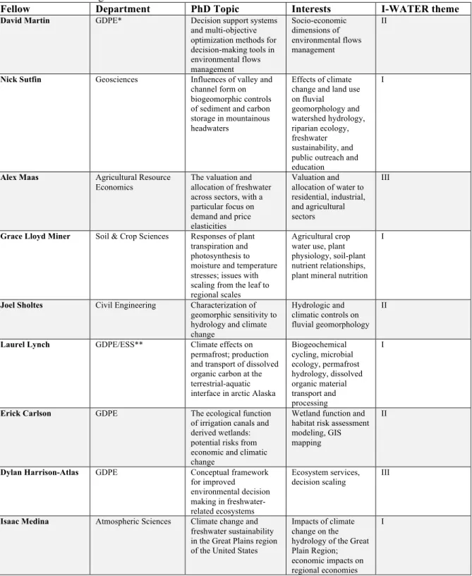
Table 1. Compiled list of research interests, PhD topic, and academic department for each I-WATER fellow, demonstrating the various fields and scales of focus
Fellow Department PhD Topic Interests I-WATER theme David Martin GDPE* Decision support systems
and multi-objective optimization methods for decision-making tools in environmental flows management Socio-economic dimensions of environmental flows management II
Nick Sutfin Geosciences Influences of valley and channel form on biogeomorphic controls of sediment and carbon storage in mountainous headwaters
Effects of climate change and land use on fluvial geomorphology and watershed hydrology, riparian ecology, freshwater sustainability, and public outreach and education
I
Alex Maas Agricultural Resource Economics
The valuation and allocation of freshwater across sectors, with a particular focus on demand and price elasticities Valuation and allocation of water to residential, industrial, and agricultural sectors III
Grace Lloyd Miner Soil & Crop Sciences Responses of plant transpiration and photosynthesis to moisture and temperature stresses; issues with scaling from the leaf to regional scales
Agricultural crop water use, plant physiology, soil-plant nutrient relationships, plant mineral nutrition
I
Joel Sholtes Civil Engineering Characterization of geomorphic sensitivity to hydrology and climate change
Hydrologic and climatic controls on fluvial geomorphology
II
Laurel Lynch GDPE/ESS** Climate effects on permafrost; production and transport of dissolved organic carbon at the terrestrial-aquatic interface in arctic Alaska
Biogeochemical cycling, microbial ecology, permafrost hydrology, dissolved organic material transport and processing I
Erick Carlson GDPE The ecological function of irrigation canals and derived wetlands: potential risks from economic and climatic change
Wetland function and habitat risk assessment modeling, GIS mapping
II
Dylan Harrison-Atlas GDPE Conceptual framework for improved environmental decision making in freshwater-related ecosystems
Ecosystem services, decision scaling III
Isaac Medina Atmospheric Sciences Climate change and freshwater sustainability in the Great Plains region of the United States
Impacts of climate change on the hydrology of the Great Plain Region; economic impacts on regional economies
I
*GDPE = Graduate Degree Program in Ecology; **Ecosystem Science and Sustainability
Evaluation
The I-WATER fellows reviewed a number of complex measures and metrics to
validate and evaluate the contributions of IDR (Garfield et al. 1978; Schmidt, 2011; Klein, 2008) and decided to use a simple criterion adapted from Wagner et al. (2011). Given the
nature of IDR, choosing evaluation metrics can be difficult. In the past, much of these evaluation methods were based on bibliometrics, but such metrics only represent limited aspects of high quality research. Citations are often used in many disciplines to determine the significance or impact of a particular manuscript or study (ibid). Again, this may only assess limited aspects of IDR. Instead we should ask how a research project can be judged on the effectiveness of the proposed solution to real world problems. Any metric used in the evaluative process must incorporate the concept of knowledge integration and
recognize that integration can occur in a single mind or within a team. But the importance of providing quantitative evaluative measures like bibliometrics may be over emphasized, when assessing the contribution of research focused on practical application. For example, we might consider asking a different question, such as “Did the research contribute to an applicable solution?” Given the needs for interdisciplinary research to address pressing societal problems, the metric most relevant to prove its success may in fact be the contribution a project makes toward solving such problems.
Components of Project Development
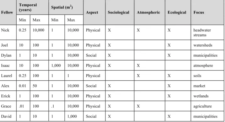
Initial consensus among the group affirmed inherent difficulties in communication and presentation of information across disciplines. Large discrepancies in the spatial extent and resolution typical of investigations performed within each of our core disciplines prompted assessment of scales corresponding to our research domains. To evaluate differences in scale and to assess compatibility among our respective disciplines, we compared the spatial and temporal dimensions characteristic of the disciplines of each Fellow (Table 2).
A general finding is that processes investigated over short time periods are often examined within smaller spatial extents (i.e., there is a space-time correspondence). Given the pivotal role played by future atmospheric conditions as defined in our Scenario, we were keen on understanding the finest spatial resolution afforded by climate change projections and the potential implications this would have for restricting inferences from other disciplines. To facilitate project development, we categorized each Fellow’s research interests and expertise according to social, atmospheric, and ecological disciplines. Using this information, we divided into subgroups representing different facets of the I-WATER integration schematic (Figure 1).
Early stages of project development focused on identifying knowledge gaps within and across our respective disciplines. Specifically, we wanted to know how well existing models, tools, and frameworks supplied by our respective disciplines could be applied to evaluate implications of the scenario on our chosen social, ecological, and physical
endpoints. Our decision to intentionally formulate cross-cutting questions meant that many of our questions required methodological approaches not fully encompassed within any single discipline. For this reason, we anticipated that a useful semester-end product would include an evaluation of the knowledge gaps present within our interdisciplinary
framework.
We recognized this as an ambitious task for the semester and one that would necessitate a thorough literature review with less opportunity for innovative thinking
within the group. Given this reasoning, we decided to pursue an alternative project that met the following criteria:
i. Truly interdisciplinary
ii. Incorporates expertise and research interests of all I-WATER Fellows iii. Provides meaningful product by the end of the semester
iv. Affords opportunities for continued research in subsequent semesters
Table 2. Comparison of temporal and spatial scales of analysis for research performed by I-WATER Fellows. Fellow
Temporal
(years) Spatial (m2) Aspect Sociological Atmospheric Ecological Focus
Min Max Min Max
Nick 0.25 10,000 1 10,000 Physical X X X headwater
streams
Joel 10 100 1 10,000 Physical X X watersheds
Dylan 1 10 1 10,000 Social X X municipalities
Isaac 10 100 1,000 10,000 Physical X X atmosphere
Laurel 0.25 100 1 1 Physical X X soils
Alex 0.01 50 1 10,000 Social X X market
Erick 1 100 1 10,000 Physical X X wetlands
Grace .01 100 .1 10,000 Physical X X agriculture
David 1 10 1 1,000 Social X X municipalities
Much of our initial approach was modeled after that described in the interdisciplinary environmental decision-making framework proposed by Liu et al. (2008). For example, we emphasized the importance of formulating integrating science questions as a foundational basis for our project. We also defined our Scenario in terms that were deliberately
amenable to different management actions and relevant to our core scientific disciplines. We evaluated the spatial and temporal scales characteristics of our respective research domains and used that knowledge to inform the types of questions we could reasonably address. Lastly, some of the sub-groups adopted conceptual modeling as a key
communications tool for explicitly linking various research components and for simplifying the representation of complex procedures.
One of the challenges in performing interdisciplinary research is in reconciling the different knowledge structures employed by each discipline. Although we opted to pursue this particular project from a qualitative perspective because of time constraints, we
recognized that a real-world solution to this problem would require integration of disparate forms of knowledge and quantitative model outputs. Liu et al. (2008) discuss uncertainty as a major barrier to decision-making and this includes the uncertainty that increases with
each step of an interdisciplinary analysis. For example, to evaluate the significance of our scenario on ecological endpoints we would need to:
i. Project large-scale atmospheric changes
ii. Downscale this projection to a smaller, more appropriate spatial resolution iii. Feed changes in atmospheric conditions into a hydrology model
iv. Predict fluvial response from altered hydrology, and
v. Assess ecological responses to altered hydrological and physical conditions. Successfully linking each of these steps together requires consideration of knowledge structures offered by atmospheric science, hydrology, fluvial geomorphology, and riverine ecology. As suggested by Table 2, substantial discrepancies in scales investigated by each discipline contribute to the challenge of performing this type of inter-linked research. Additional challenges stem from reconciling different levels of precision, degrees of predictive accuracy, and limited data availability for use in developing and evaluating models (Benda et al. 2002).
Several strategies for achieving compatibility of diverse knowledge structures are presented by Benda et al. (2002) as a means to overcome traditional barriers to interdisciplinary research. For example, integration of qualitative and quantitative information is possible by modifying the level of precision used in an analysis to
accommodate the uncertainties and knowledge structure of a less quantitative discipline. Additionally, describing longer term behavior over large spatial scales may yield better predictions of ecological responses that are driven more strongly by stochastic disturbances at smaller spatial and temporal scales. In cases where considerable knowledge gaps
preclude a process-based analysis, changes in hydrology may be assessed at the watershed level using standard regression or classification and regression tree type approaches to relate catchment features and atmospheric forcings to an outlet hydrograph (Benda et al. 2002). The obvious challenges of interdisciplinary research may be offset by the potential benefits of improved environmental decision-making resulting from holistic evaluation of complex problems with multiple drivers. Careful consideration of these and other
strategies facilitates communication across disciplines and enables integration of diverse knowledge structures to strengthen inferences drawn from an interdisciplinary perspective. Scenario Description and Design
In 2012 carbon dioxide emissions rose to 2.4 million pounds per second, making anthropogenic climate change the largest scale experiment ever conducted (Peters et al. 2012). The heat trapping properties of greenhouse gases have altered land-surface interactions, perturbing both global and regional systems. In Colorado, average
temperatures have already increased 2°F in the past thirty years. Regional climate models project temperature increases of 2.5°F by 2025 and 4.0°F by 2050, with the majority of the warming occurring during summer months (Ray et al., 2008b). The combination of warmer temperatures and less precipitation have been linked to increased frequency and intensity of wild fires and beetle-kill outbreaks (Simard 2008). Forest mortality has altered the surface albedo perturbing land-surface interactions of radiation and gases. Changes in rainfall and evaporation rate are altering seasonal river hydrographs and have potentially
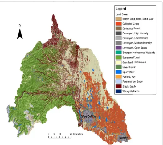
destabilizing environmental impacts. The I-WATER interdisciplinary team examined approaches to assess the potential impact of climatic change on future water supply and demand throughout the Cache la Poudre River Watershed in the Front Range of northern Colorado. This assessment includes efforts to identify underlying ecological and
socioeconomic vulnerabilities within the system. The complex environmental and management issues facing freshwater sustainability in the Poudre Watershed require solutions that are beyond the scope of a single discipline. Integration of disciplinary perspectives and methodologies will facilitate improved understanding of the watershed and associated vulnerabilities.
Figure 2. 2001 National Land Cover Dataset Depiction of the Cache la Poudre River Basin. (Prepared by Kampf et al., 2010)
Background: The Cache La Poudre River Watershed
The Poudre River flows east from its headwaters in Rocky Mountain National Park into the South Platte River, draining approximately 4,900 km2 of the Colorado Front Range and adjacent plains (Figure 2, Wohl 2008). Annual average precipitation ranges from 15 inches on the plains at the base of the Colorado Front Range (4,590 ft elevation) to 52 inches at the mountainous headwaters in the alpine region of Rocky Mountain National Park (13,520 ft elevation), with a basin-wide average precipitation at approximately 18 inches (USDA, 2009). Longer duration, widespread frontal storms are common in the spring and early summer while frequent high-intensity convective storms occur in afternoons during late summer.
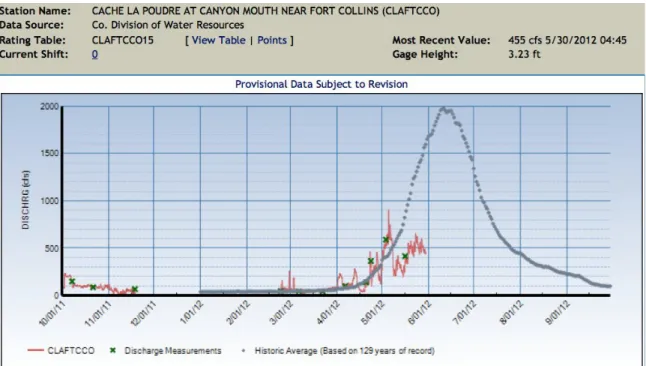
The Poudre River hydrograph is snowmelt dominated typically resulting in a single annual maximum discharge averaging approximately 2483 ft3/s (1976-2011) and typically peaking sometime in early to mid-June (USGS). Two-thirds of the Poudre's total annual volume is discharged within a two-month period, between mid-May and mid-July (Figure 3). Model projections indicate reduced snowfall, increased rain-on-snow events, and warmer springs will result in earlier runoff events and greater reductions in late summer stream flow (Ray et al., 2008b). In addition to decreased flow, declines in water quality are predicted as atmospheric deposition of pollutants increases. These pollutants are
predominantly nitrogen byproducts from agriculture and industry, and have resulted in episodic acidification events in alpine lakes and streams (Baron et al., 2000). Upstream nutrient saturation has a cascading effect upon downstream freshwater ecology and biogeochemical cycling. Flow diversions and augmentations, changes in the timing of snowmelt, and increased demand for water not only limit the ability of the natural system to dilute pollutants and excess nutrient loading, but also alter the hydrologic flow regime, sediment dynamics, and channel geometry responsible for maintaining integrity of freshwater ecosystems and ecosystem services.
Figure 3. Cache la Poudre River Hydrograph, 2012. Peak discharge occurred mid-June. (Prepared by Colorado Division of Water Resources, 2012).
Seasonal changes in water availability will impact water storage facilities, including Horsetooth Reservoir, which diverts water to the Poudre River in late summer to subsidize eastern plains irrigation (Billica 2010). Future pressure on Horsetooth Reservoir to supply water for residential use may force farmers to respond by altering irrigation practices or selecting drought-tolerant or water-efficient crops. Trans-basin diversions, particularly from the Colorado River via the Grand River Ditch, currently subsidize Poudre flows, but are also predicted to experience flow reductions (Beaujon 2009). Colorado water laws are governed by Prior Appropriation Laws, which prioritize water rights by application date.
As a result, junior water right holders, including the city of Fort Collins, will be impacted first if supply decreases.
Approach for Assessment of the Cache La Poudre Watershed
We began our assessment of the Poudre River Watershed by characterizing the physical system into three zones of distinct land uses associated with different water supply and usage regimes. We then conducted a literature review and compiled regional climate change projections. After identifying critical drivers and processes affecting the Poudre River system at multiple scales we divided the watershed spatially into reaches to focus our assessment. Conceptually, the uppermost portion extends eastward from the alpine and subalpine headwaters of the Front Range to the mountain foothills. The intermediate reach includes the base of the foothills, grasslands, the city of Fort Collins, and all municipal, industrial and residential water usage. The lower reach encompassed the high plains to the east and south of the city, a productive agricultural region. After
identifying uncertainties associated with each spatial region we began constructing an integrative conceptual model.
Following several weeks of discussion, we revised our group structure to reflect the original I-WATER framework, splitting into three subgroups to assess potential
environmental, atmospheric and social responses to reductions in water availability. The I-WATER group focused on integrating aspects of ecology and atmospheric sciences with hydrology assessed the impacts of reduced snowpack on the upper portion of the Poudre River Watershed. The group focused on integration of ecology, hydrology, and social systems developed a framework for addressing ecological and socioeconomic challenges to identify vulnerabilities in adaptation of freshwater systems. To integrate atmospheric sciences, hydrology, and social systems, the third group evaluated how the agricultural sector, the primary regional freshwater user, could respond to changes and uncertainty in water supply as demand increases. Subgroups met individually to discuss pertinent issues and the cohort met weekly to integrate subtopics and revise research directions. Conceptual frameworks and vulnerabilities identified by each subgroup are included in the next section. Interdisciplinary Work by Theme Groups
Research Theme I; Hydrologic Atmospheric and Ecologic Systems (HAE)
The impacts of climate change on fresh water resources and the ecosystem are a great concern for the Poudre Watershed. In the HAE subgroup, we focused on the coupled atmospheric, ecologic and hydrologic processes impacting the watershed. We divided the watershed into three sub-regions classified as the source, transport, and sink region. Within each sub-region, we identified climate change vulnerabilities and the uncertainties
surrounding those vulnerabilities. Literature reviews and the current development of a conceptual model were used to gain a better understanding of the scales, sources and mechanisms comprising the complex ecosystems of the Poudre Watershed along with the potential impacts of climate change on these systems.
The source region corresponds to the headwaters of the Poudre River in Rocky Mountain National Park. In this region of the watershed, impacts of climate change on nitrogen deposition rates are of great concern. Currently there is an increasing gradient of
nitrogen deposition from west to east (west side receives 1-2 kg N y-1 and east side receives ~ 3-5 kg N y-1), with nitrogen sources originating from feedlots, agriculture and urban emissions (Baron et al. 2000). The mountain-plains circulation is the primary mechanism for depositing nitrogen in Rocky Mountain National Park, creating many potential ecosystem-related problems, such as the acidification of surface waters (Baron et al. 2000 and Musselman et al. 1996). Understanding the impacts of climate change on the current regional atmospheric circulation and nitrogen deposition rates is critical for the watershed - subtle changes in nitrogen deposition can drastically alter ecosystem
functioning (Musselman et al. 1996). Early management actions are crucial for the survival of current mountain ecosystems as well as those downstream.
Coupled to the source region, the transport region stretches from the headwaters of the Poudre River down to the urban corridor. In this region of the watershed the impacts of climate change on vegetation cover and snow retention are the main concerns. The region is currently dominated by sagebrush shrub land on the southern and eastern slopes, with ponderosa pine transitioning into lodgepole pine and spruce at lower elevations on northern and western facing slopes (Baron et al. 1998 and Stohlgren et al. 1998). In addition to potential changes in future snowfall, other mechanisms impacting snow retention include topography and changes in forest composition (e.g., coniferous,
deciduous or mixed forests). The impacts of climate change will likely play a key role in future forest composition, forest health, and susceptibility to fire (pine beetle).
Additionally, climate change could impact ground level snow accumulation and retention, which is very important for the release rates of deposited nitrogen (Baron et al., 1998; Sohlgren et al. 1998).
Finally, coupled to the source and transport region, the sink region corresponds to the urban corridor through the eastern plains of Colorado. In this region of the watershed there are concerns over the impacts of climate change on microscale and mesoscale circulations due to potential changes to current irrigation and urban practices. In addition to large-scale atmospheric circulations, other mechanisms driving the current regional mesoscale
circulations include i) upstream forest composition, ii) urbanization and iii) agricultural practices (Chase et al. 1999). The impacts of climate change on current irrigation practices may impact local microclimates on the eastern plains as well as the mountain-plains
circulation - some studies suggest a strong coupling between soil moisture and atmospheric processes in this region (Koster et al. 2002; 2003; 2006 and Guo et al. 2006). Moreover, the impacts of climate change on synoptic scale atmospheric motions are also a source of concern and great uncertainty.
There are great uncertainties surrounding the impacts of climate change on the
freshwater ecosystem of the Poudre Watershed. Examination of three coupled sub-regions within the watershed facilitated isolation of climate change vulnerabilities and
uncertainties surrounding those vulnerabilities. Additionally, with the current and ongoing development of a conceptual model, we hope to gain a better understanding of the impacts of climate change on the mechanisms driving the watershed ecosystems. Preliminary conclusions elucidate that the impacts of climate change on the regional microscale and meso-scale atmospheric circulations will be critical for future forest composition, nitrogen
deposition and in turn the health of the entire ecosystem. Current management practices may not be strong enough to cope with climate change, challenging the assumption that past hydrology provides a good guide to the future (Ray et al. 2008a). Members of Research Theme I believe that early management actions will be critical for the future health and survival of the ecosystems comprising the Poudre Watershed. An
interdisciplinary framework that integrates the social aspect of management, policy, and socioeconomic could provide the guidance necessary to inform land-use and water resource management.
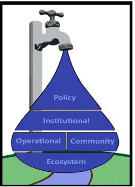
Research Theme II: Hydrologic, Ecologic and Socio-Economic Systems (HES) Competing social, ecological, and economic demands for water challenge the sustainable management of freshwater systems. Sustainability under increasing water demands and a changing climate requires an adaptive interdisciplinary approach. The complexity of decision-making within a watershed includes the potential for positive and negative feedbacks across multiple levels of organization, which are envisioned here as a hierarchy of freshwater decision systems. We use a hierarchical approach to decision systems for natural resources and apply it to water-centric resource management (Figure 4, adapted from Ciriacy-Wantrup and Bishop, 1975). This hierarchy consists of four levels that function upon the structure of lower levels while simultaneously dictating freedoms and constraints of the foundational lowest level.
At the foundation of the hierarchy, the ecosystem provides goods and services that facilitate operation of all higher levels. Actions at higher levels propagate downwards, thereby impacting the ecosystem. Separate operational and community domains within the second level of the hierarchy operate through direct interaction with freshwater ecosystems. The institutional level consists of members who regulate the operation and use of water resources and conduct appropriate assessments of the freshwater ecosystem. Political institutions function at the top level of the hierarchy with the ability to grant or restrict rights and change the regulating responsibilities of the institutional level.
Numerous feedbacks occur within all levels of the hierarchy including the pervasive effects of education concerning the benefits and requirements of the ecosystem. Depending on a given level of education and awareness, for example, individuals who make decisions within the community level may i) choose to adjust the way the community and
operational sector manage for and benefits from ecosystem services, ii) demand changes on the institutional level, ii) or facilitate a movement to influence decisions made at the policy level. Likewise, the ecological level may respond to changes or stressors in the system by altering its structure and function and consequently its ecosystem services.
Adaptive management has previously been presented as a vision for achieving multi-functional social-ecological resilience in environmentally constrained parts of the world. Implementation of adaptive management in snowmelt-driven watersheds, those
particularly at risk to changing climate, requires leveraging insights afforded by interdisciplinary perspectives to vulnerability. We present a research and development framework for assessing vulnerable processes at each level of the hierarchy of freshwater decision systems (Figure 5).
Vulnerability assessments must address the dynamic inter-linkages of processes occurring in order to be successful. Processes within a decision system are exposed to a specific scenario or stressor through distinct pathways resulting in time-sensitive responses and outcomes. The degree of change associated with each process depends upon the magnitude of the pathway, degree of external exposure of the processes to the scenario, and internal sensitivity of the process. Sensitivity is defined by the degree of change within a process associated with a given level of exposure. In other words, the degree to which the process changes as a function of the scenario depends on the magnitude and duration of the exposure and sensitivity of that process to the stressor. Adaptive capacity is defined by the ability to mitigate the degree of exposure or sensitivity of each process to the scenario.
Figure 4. A hierarchical approach to decision systems for natural resources. Adapted from Ciriacy-Wantrup and Bishop, 1975.
Figure 5. Framework for assessing the vulnerability of processes under distinct scenarios affected by pathways within hierarchical levels of decision-making for management of water resources.
We are currently highlighting key processes at each level of the freshwater hierarchy of decision systems to present their differential vulnerabilities through a characterization of exposure, sensitivity, and adaptive capacity. Our focus is on the Poudre River Watershed and a unique climate change scenario that will provide difficult water allocation issues in the coming decades. In doing so, we identify feedbacks experienced between processes at higher constraining levels and lower foundational levels. This dynamic decision system in Colorado offers several key insights for future research and development of approaches in adaptive management.
One of the greatest challenges in addressing issues regarding sustainability of
freshwater resources occurs within the communication gap between the various levels of the hierarchy. The inability to assess all aspects of freshwater systems with a unified framework hinders the resilience of current infrastructure and institutions to respond to a
changing climate, rising water demand, and the degradation of ecosystems. The framework presented here establishes a unified approach that can be applied across all levels of the decision-making hierarchy. Scientists are familiar with identifying the pathways by which a specific scenario (e.g., less availability of water and lower flows) affects physical or biological processes (e.g., high flows required to flush the system of fine sediment to facilitate spawning areas for native fish species). The sensitivity of this process (i.e., the degree of change associated with the level of exposure) to limited water availability depends upon the level of exposure (e.g., a single year of low flows vs. continued long-term trends of low flows) and the magnitude of the pathway (i.e., the quantity of reduced maximum flows). Adaptive capacity to mitigate change in the process includes internal adaptation with regard to sensitivity of the natural system and external adaptation with regard to the level of exposure to the changes in the process.
In this example, the exposure can be altered externally by instituting an environmental flow to flush fine sediment from the system. Implementing this framework as described in this example provides an opportunity to study the ecological response, closing knowledge gaps regarding the process and sensitivities within the system. The cyclical nature of this framework facilitates incorporation of new insights to strengthen future decision-making within an adaptive management program.
Research Theme III: Hydrologic, Atmospheric and Socio-Economic Systems (HAS)
The HAS sub-group focused on the capabilities and limitations of economic and physical sciences in predicting the change in the timing and magnitude of future water supplies, as well as the agricultural and social responses and associated impacts. Here we present a brief review of the state of the science concerning these questions. We would like to continue pursuing these questions in a more thorough and explicit assessment through a case study of the Colorado Front Range’s agricultural response to past and potential future water shortages.
Climate change is likely to increase the vulnerability of our water supply systems. Projected increases in global temperatures are predicted to cause a variety of changes in regional precipitation: both increases and decreases depending on a number of geographic and climatic factors (IPCC 2007). Quantifying the change in runoff, or the surface
hydrological response, to changes in precipitation depends on the complex interaction between precipitation, evapotranspiration, vegetation, storage and conveyance of water. Much effort has been made to quantify changes in runoff due to climate change in the Colorado River, whose headwaters supply the Front Range through inter-basin transfers. According to a summary of these by Rajagopalan et al. (2009), “The preponderance of evidence from extensive recent literature on the probable effect of climate change is that the Colorado River average annual flow will decline.” Though the specific mechanism for this decline found by these studies might vary in some respect, the overall reason for this decline is likely due to an increase in evapotranspiration over temporal changes in
precipitation: namely decreased quantity and increase variability in summer precipitation (Christensen and Lettenmaier 2007). This means that projected population growth in Colorado and its concomitant increase in demand for water (CWCB 2010) will likely result
in an even greater water supply shortage than that which has been estimated by using historic flow data. Indeed, Rajagopalan et al. (2009) estimate a ten-fold increase in the probability of Colorado River basin reservoir depletion by 2057 when incorporating projected flow decreases due to climate change over those probabilities estimated only using historic and paleo-records.
The challenge in predicting future water supplies lies in the large —and mostly un-quantified— uncertainty associated with climate change projections. There are many examples of climate change projections being incorporated into future water supply assessments. However, these studies often utilize top-down modeling approaches for prediction (e.g., Izaurralde et al. 2003). Under this framework, modelers use general circulation model (GCM) projections and temporal and spatial downscaling methods to provide inputs for hydrologic models. Often high and low greenhouse gas emissions scenarios are used with an ensemble of GCMs to provide an upper and lower limit of potential outcomes. However, this approach can result in a potentially large range of predicted future water needs. Additionally, the compounding uncertainty cascading from model to model can lead to wide ranges of predicted conditions that are often intractable for decision-making (Jones 2000, Johnson & Weaver 2009, Brown et al. 2012). Other workers have suggested an inverse or bottom-up approach to better assess future human and environmental water needs.
To implement this approach, first the history of water supply sensitivity to climate variables (e.g., annual or seasonal temperature and precipitation) is characterized and a threshold of system reliability is established. This threshold can be thought of as a
specified tolerance of probability of a system not failing (Brown et al. 2012). A Bayesian-Monte Carlo approach applied to GCM outputs has been used to create probability
distribution functions of future climate conditions (Jones 2000, New & Hulme 2000). The probabilities of future climate conditions can then be compared to the threshold of climate conditions that result in a departure in the reliability threshold previously identified. Hence, the probability of future system reliability can be quantified and robustness of mitigation plans evaluated. The water resources management scientific community has adapted this approach from climate scientists who are developing better methods for utilizing uncertain climate change projections in decision-making (Jones 2000, New & Hulme 2000, Brown et al. 2012). Robust decision-making (e.g., Lempert & Collins 2007) is related to this
approach, but considers which water supply planning or mitigation strategies perform the best under the range of potential future scenarios.
Agriculture faces a dual challenge in the coming decades – increase production to feed an increasing number of people while simultaneously conserving soil and water resources. Significant uncertainty remains about the impacts of climate change on agro-ecological systems. Not only is there uncertainty about the magnitude, in some cases there is uncertainty about the “direction of the associated impacts” (Tubiello et al., 2007). Plant responses to elevated CO2, temperature, and water stress are complex – additionally, many
important plant growth factors such as pests, weeds, nutrients, and soil water interact with climate change variables.
Changes in temperature, CO2, precipitation and evaporation can modify the
productivity and function of agro-ecosystems in confounding ways, and the interactions of these variables need additional study and scaling up. For example, while elevated CO2
tends to increase plant biomass and yield, increased temperatures could indirectly reduce CO2 effects by increasing water demand. However, water use efficiency may be increased
under elevated CO2 due to stomatal closure and higher root densities, potentially providing
a counterbalance to drought pressures. While some of these dynamic interactions with climate change variables are understood at a single-plant level, “large-scale implications for whole ecosystems are not well understood” (Tubiello et al., 2007). An additional uncertainty comes along with projected increases in extreme climatic events, which may lower yields by damaging or stressing crops at important developmental stages (i.e., if temperature thresholds are crossed during flowering or pollination, causing ovary abortion or lack of pollination). Climate extremes can also increase disease pressures and pest outbreaks. Tubiello et al., (2007) summarize the state of the science well, stating that:
…Experimentally observed crop and pasture physiological responses to climate-change variables at plot and field levels are too simplified in current models. As a consequence, the potential for negative surprises is not fully explored, thus reducing the level of confidence in regional and global projections. Key interactions that are currently poorly described by crop and pasture models include: (i) nonlinearity and threshold effects in response to increases in the frequency of extreme events under climate change; (ii) modification of weed pest and disease incidence; (iii) field
response of crops to elevated CO2 concentration; and (iv) interactions of climate and
management variables with elevated CO2.
In order to reduce uncertainties, increase confidence in impact projections and quantify future risks, we need to continue research on the interacting crop responses to climate change variables.
Finally, we discuss the abilities and limitations of economics to predict agricultural response to potential changes in water supply. Colorado assigns water rights according to the “Prior Appropriation” doctrine in which users who legally establish a “beneficial use” to a certain volume and timing to water are assigned a right to that water. In times of shortage, the most “senior” water right holder, or earliest-established right, will have their water delivered before “junior” water rights holders receive theirs (Colorado Foundation for Water Education, CFWE 2004). Within that legal framework, water rights can be leased and sold outright, offering some flexibility, but these markets are often slow with substantial transactions costs. Additionally, the market is limited by the requirement to not “injure” downstream water right holders from water transfers and by the physical ability to store and transfer water (CFWE 2004, Brooks & Harris 2008). Linear optimization models are often utilized to determine optimal water allocation scenarios (e.g., Yamout & El-Fadel 2005, Sahoo et al. 2006), but these allocations may not be practical given transaction costs, water rights limitations, and the uncertainties of externalities associated with allocative changes. Additionally, predicting the elasticity of future agricultural water demand for various sectors (Residential, agricultural, industrial, etc.) continues to pose a theoretical and empirical challenge due to the complexity of the water market and our economic modeling techniques (Watson et al. 1980, Brooks & Harris 2008).
It is clear from this brief review that a large number of uncertainties continue to challenge our ability to predict future water supplies, demands, and economic impacts. However, even if perfect predictions were possible, significant social and perhaps physical limitations may limit our ability to respond and mitigate. Potential physical limitations may involve the limit of water present in Colorado available to appropriate for human use. The social limitations include the political and legal considerations of water rights holders — who are not always rational market participants— and how Colorado manages its future growth as a state.
Conclusions and Reflection
The goal of this Fall 2012 I-WATER Research Theme was to apply fundamental interdisciplinary scientific methods to a complex problem, separate into specific research theme subgroups, and record our integration techniques and methods along the way. The value of interdisciplinary research is most evident when integration is initiated at the beginning of project development. However, we acknowledge that research is only one facet to a growing sustainability science directive that requires education and decision making to be a part of a holistic interdisciplinary scientific process. IDR’s effectiveness at this stage increases the longer it exists as a fundamental principle guiding the interaction and flow of information between I-WATER fellows. Collaboration that involves
integration of the individual’s personal interests and knowledge allows groups of scientists to anticipate theoretical problems, design a robust experiment or sampling methodology, and potentially apply their results to increasing spatio-temporal scales and problems. With the Fall 2012 I-WATER Research Theme as a foundation, we are interested in
collaborative efforts that will truly integrate the three facets of a holistic interdisciplinary science (education, research, decision analysis) as this research theme continues to develop.
The cohort for this Fall 2012 I-WATER Research Theme took many initial approaches to identifying and framing a problem, a key component of which was familiarizing
ourselves with one another’s work and interests to facilitate integration of each person’s expertise appropriately. . Off-campus meetings help make the initial meet and greet
process a success. For more than a month the complete group of I-WATER fellows met on a weekly basis to discuss how interdisciplinary research has previously been conducted. Realization of a local real-world problem in the Poudre Watershed with a perceived interdisciplinary solution provided a broad goal, which was progressively narrowed and defined as knowledge gaps and overlapping scales were identified. Each I-WATER subgroup eventually took research paths from problem formulation through an integrated process towards discipline-specific frameworks for conceptualizing the problem. The unique paths that each subgroup took are meant to illustrate a logical approach to
integrating discipline-specific specialists towards a common goal. This provides a strong foundation that will initiate the next phase of a holistic interdisciplinary scientific process addressing the problem of climate change in the Poudre Watershed.
During the Spring of 2013, discipline-specific seminars will be designed to educate all members of I-WATER about the subgroup’s unique approach to conceptualizing the specified problem as a way to “prepare by committee,” a final project, and the potential of
a scientific paper that recommends a solution. The timeline and topics are designed to: 1) introduce fundamental academic papers from each subgroup that are required to
understand the problem from alternative perspectives, 2) inform each member with a synthesis session that pulls from the unique conceptual frameworks derived during Fall 2012, 3) gain alternative perspectives and feedback from the other subgroup’s expertise on the focus of each Research Theme, and 4) to finally integrate our approaches into one comprehensive model that will continue after Spring 2013 and be used in decision analysis. Specifically, three seminars will explore each of the I-WATER Research Themes. The first will be focused on pivotal research in individual disciplines and how such knowledge is important for all members to understand when approaching this climate change issue on the Poudre Watershed. The second seminar will focus on how the research presented in seminar one is applicable to our model system. The third seminar will focus on promoting and educating our approach to other systems, which is thought of as a feasibility approach to scaling-up each subgroup’s framework to other parts of the country. These nine
seminars will be preceded by an introductory meeting to the project to align the members’ thinking and followed by two seminars to integrate the organization of a potential model solution that may utilize facets of each subgroup’s progress into a final deliverable (e.g. academic paper) to be used as a tool for decision makers.
The results of this Fall 2012 I-WATER Fall Research Theme will be applicable to future I-WATER Research Themes as it provides a foundational interdisciplinary research agenda and approach. We have conducted interdisciplinary research within our subgroups where science, theory, and practical methods were discussed and integrated. The
synergistic scientific effort performed within subgroups must be progressively integrated to provide holistic interdisciplinary science a multiplicative benefit through incorporating education and decision analysis. This Fall 2012 interdisciplinary work prepares I-WATER fellows for application and presentation in Spring 2013 when educational seminars will be administered to synthesize the subgroups’ work into a comprehensive approach for
managing and making decisions with regard to freshwater resources in mountainous regions of the western United States.
Recommendations
Working closely as specialists from diverse disciplines, I-WATER fellows offer seven recommendations to further effectiveness of IDR. First, the formulation of specific
research questions should be a collaborative process (1), which involves members from each field relevant to the problem. By incorporating scientists from different disciplines in this first stage, research groups can choose the appropriate temporal and spatial scales (2), which often differ drastically between fields. Integration of research at various scales depends on the research question, knowledge gaps, goals, and desired outcome of the interdisciplinary work. Identification of the knowledge gaps present within and between disciplines (3) is an important step to help define the research questions and goals. Particular effort should be made to specify the desired final products of IDR before significant research begins (4). As the process continues, these products should be revisited and redefined as feedbacks and feasibility of the study become clearer (5). A crucial component of IDR with involves an adaptive approach that not only considers feedbacks between various aspects of the system, but also investigates the need for
additional considerations previously undefined or addressed by the original disciplines, research question, and management decisions. An iterative approach is necessary to reexamine the problem and research question (6) as understanding of relationships in the natural and socioeconomic systems increase. Because IDR involves identification of knowledge gaps between disciplines with distinct spatial and temporal scales, continuous reexamination of the research question is necessary. The approach best suited for this iterative processed is to define broad goals and progressively redefine them to address more specific research questions (7) as understanding increases regarding relationships in the system being examined.
References
Baron JS, Hartman MD, Kittel TGF, Band LE, Ojima DS, Lammers RB. 1998. Effects of Land Cover, Water Redistribution, and Temperature on Ecosystem Processes in the South Platte Basin.Ecological
Applications 8: 1037-1051.
Baron JS, Rueth HR, Wolfe AM, Nydick KR, Allstott EJ, Minear JT, Moraska B. 2000.
EcosystemResponses to Nitrogen Deposition in the Colorado Front Range. Ecosystems 3: 352-68. Beaujon D. 2009. Regulation of Transbasin Diversions and Large Water Transfers. Colorado
LegislativeCouncil Staff.
Benda L, Poff NL, Miller D, Dunne T, Reeves G, Pess G, Pollock M. 2004. The network
dynamicshypothesis: how channel networks structure riverine habitats. Bioscience 54: 413–427. Billica J and Oropeza J. 2010. Horsetooth Reservoir Water Quality Monitoring Program Report. City ofFort
Collins Water Resources & Treatment Services. Cache La Poudre River Hydrograph, 2012.
Boulding K. General Systems Theory—The Skeleton of Science. Management Science April 1956 vol. 2 no. 3 197-208
Colorado's Surface Water Conditions. Colorado Division of Water Resources. www.dwr.state.co.us
Brooks R, Harris E. 2008. Efficiency gains from water markets: Empirical analysis of Watermove inAustralia. Agricultural Water Management 95: 391-399.
Brown C, Ghile Y, Laverty M, Li K. 2012. Decision scaling: linking bottom-up vulnerability analysiswith climate projections in the water sector. Water Resources Research 48: 9537–9549.
Chase TN, Pielke Sr. RA., Kittel TGF, Baron JS, Stohlgren TG. 1999. Potential impacts on ColoradoRocky Mountain weather due to land use changes on the adjacent Great Plains, Journal of Geophysical Resources. 104: 16673-16690.
Christensen N and Lettenmaier DP. 2007. A multimodel ensemble approach to assessment of climatechange impacts on the hydrology and water resources of the Colorado River basin. Hydrology and Earth System Science 11: 1417–1434.
Colorado Water Conservation Board (CWCB). 2010. Yampa/White state water supply initiative basinreport. 64 p. http://cwcb.state.co.us/water-management/basin-roundtables/Pages/main.aspx
Colorado Foundation for Water Education. “This Citizen’s Guide to Colorado Water Law”, 2nd Ed. 2004.
http://www.cfwe.org Accessed December 13, 2012. 36p.
Ciriacy-Wantrup SV and Bishop RC. 1975. “Common Property” as a concept in natural resources policy.Natural Resources Journal 15:713-728.
Garfield E., M. Malin, and. H Small, Citation and Science Indicators, Published in Toward a Metric of Science: The Advent of Science Indicators (New York: John Wiley, 1978).
Guo Z, and Coauthors, 2006: GLACE: The Global Land–Atmosphere Coupling Experiment. Part II:Analysis. Journal of Hydrometeorology 7: 611–625. doi: http://dx.doi.org/10.1175/JHM511.1
Howitt RE, Watson WD, Adams RS. 1980. A reevaluation of price elasticities for irrigation water. Water Resources Research 16: 623-646.
Intergovernmental Panel on Climate Change. 2007. Climate Change 2007: The Physical Science Basis— Contribution of Working Group I to the Fourth Assessment Report of the IntergovernmentalPanel on Climate Change, edited by S. Solomon et al., 996 pp., Cambridge Univ. Press, NewYork.
Izaurralde RC, Rosenberg NJ, Brown RA, Thomson AM. 2003. Integrated assessment of Hadley
Center(HadCM2) climate-change impacts on agricultural productivity and irrigation water supply in the conterminous United States Part II. Regional agricultural production in 2030 and 209. Agricultural and Forest Meteorology 117: 97–122.
Johnson TE and Weaver CP. 2009. A framework for assessing climate change impacts on water and watershed systems. Environmental Management 43: 118–134.
Jones R. 2000. Managing uncertainty in climate change projections – issues for impact assessment. Climate Change 45: 403–419.
Kampf SK, and Richer EE. 2010. Hydrologic Analysis and Process-Based Modeling for the Upper CacheLa Poudre Basin. Colorado Water Institute. Colorado State University. www.cwi.colostate.edu .
Klein, J. Evaluation of Interdisciplinary and Transdisciplinary Research A Literature Review. American Journal of Preventive Medicine. 2008;35(2S):S116 –S123
Koster RD, Dirmeyer PA, Hahmann AN, Ijpelaar R, Tyahla L, Cox P, Suarez MJ. 2002. Comparing thedegree of land-atmosphere interaction in four atmospheric general circulation models. Journal of Hydrometeorology 3: 363-375.
Koster RD, Suarez MJ, Higgins RW, Van den Dool HM. 2003. Observational Evidence that soil moisturevariations affect precipitation. Geophysical Resource Letters 30: 1241
doi:10.1029/2002GL016571.
Koster RD, and Coauthors, 2006: GLACE: The Global Land-Atmosphere Coupling Experiment. Part I:Overview. Journal of Hydrometeorology 7: 590-610.
Lempert RJ, Collins MT. 2007. “Managing the Risk of Uncertain Threshold Responses: Comparison ofRobust, Optimum, and Precautionary Approaches.” Risk Analysis. 27: 1539-6924.
Liu Y, Gupta H, Springer E, Wagener T. 2008. Linking science with environmental decision making:Experiences from an integrated modeling approach to supporting sustainable water resourcesmanagement. Environmental Modelling & Software 23: 846-858.
Musselman RC, Hudnell L, Williams MW, Sommerfeld RA. 1996. Water Chemistry of Rocky MountainFront Range Aquatic Ecosystems. USDA Forest Service RM-RP-325. 1-19.
New M and Hulme M. 2000. Representing uncertainty in climate change scenarios: A Monte-Carloapproach. Integrated Assessment 1: 203–214.
Peters GP, Andrew RM, Boden T, Canadell JG, Ciais P, Le Quere C, Marland G, Raupach MR, Wilson C. 2012. The challenge to keep global warming below 2ºC. Nature Climate Change. 1758-6798. "Prior Appropriation Law." Colorado Division of Water Resources. water.state.co.us
Qin, Jian. F. W. Lancaster, and Bryce Allen, “Types and Levels of Collaboration in Interdisciplinary Research in the Sciences,” Journal of the American Society for Information Science 48, no. 10 (1997): 893–916, doi:10.1002/(SICI)1097-4571(199710)48:10<893::AID-ASI5>3.0.CO;2-X.
Rajagopalan B, Nowak K, Prairie J, Hoerling M, Harding B, Barsugli J, Ray A, Udall B. 2009.Watersupply risk on the Colorado River: Can management mitigate? Water Resource Research 45: pp7.
Ray A, Barsugli, JJ, Averyt KB. 2008a: Climate Change in Colorado: A Synthesis to Support
WaterResources Management and Adaptation, A Report for the Colorado Water Conservation Board. Available online at http://www.colorado.edu/CO_Climate_Report/index.html
Ray AJ, Brasugli JJ, Averyt KB, Wolter K, Hoerling M, Doesken N, Udall B, Webb R. 2008b.
ClimateChange in Colorado-A Synthesis to Support Water Resources Management and Adaptation. Report for the Colorado Water Conservation Board: University of Colorado at Boulder. cwcb.state.co.us. Rhoten, Diana and Andrew Parker, “Risks and Rewards of an Interdisciplinary Research Path,” Science 306,
no. 5704 (December 17, 2004): 2046–2046.
Sahoo B, Lohani AK, Sahu RK. 2006. Fuzzy Multiobjective and Linear Programming Based Management Models for Optimal Land-Water-Crop System Planning. Water Resources Management 20: 931-948. Schmidt JC. “What Is a Problem: On Problem-oriented Interdisciplinarity,” Poiesis Praxis 7, no. 4
(June2011): 249–274.
Simard M, Powell EN, Griffin JM, Raffa KF, Turner MG. 2008. Annotated Bibliography for ForestManagers on Fire-Bark Beetle Interactions. The Bark Beetles, Fuels, and Fire Bibliography.Paper 207.
Stohlgren TJ, Chase TN, Pielke RA, Kittel TGF, Baron JS. 1998. Evidence that local land use
practicesinfluence regional climate, vegetation, and stream flow patterns in adjacent natural areas. Global Change Biology 4:495-504.
Tubiello FN, Jean-François S, Howden SM. 2007. Crop and pasture response to climate change.Proceedings of the National Academy of Sciences 104,50: 19686-19690.
United States Department of Agriculture (USDA), Natural Resources Conservation Services,
ColoradoDepartment of Agriculture, and State Conservation Board, 2009. Rapid assessment for the CacheLa Poudre Hydrologic Unit Code 10190007.
United States Geological Survey (USGS) Water Resources System. Peak streamflow for Colorado USGS06752260 Cache La Poudre River at Fort Collins, CO between 1976 to 2011. National Water Information System: Web interface. http://nwis.waterdata.usgs.gov/co/nwis/peak , Accessed January 2, 2013.
Wagner, Caroline S. et al., 2011. “Approaches to Understanding and Measuring Interdisciplinary Scientific Research (IDR): A Review of the Literature,” Journal of Informetrics 5,1: 14–26,
doi:10.1016/j.joi.2010.06.004
Wohl E, Carlson EA, David G. 2008. Cache la Poudre River Drainage Basin. Department of Geosciences,Colorado State University.
Yamout G, El-Fadel N. 2005. An Optimization Approach for Multi-Sectoral Water Supply Managementin the Greater Beirut Area. Water Resources Management. 19: 791-812.