The Integration of GIS and Watershed Erosion Models to Support the
Assessment of Surface Coal Mine Reclamation
X. Shawn Huang, Anthony B. Alvarado, Lyle W. Zevenbergen1
River Engineering, Ayres Associates Inc., Fort Collins, CO
John N. Cochran
Environmental Hydrology, Peabody Energy, Flagstaff, AZ
Abstract. The technology of Geographic Information System (GIS) has been extensively applied
in numerous fields, such as watershed hydrologic/hydraulic modeling and urban stormwater modeling, during the last two decades. However, the integration of GIS and watershed erosion models receives little attention primarily because of the complexity of sediment routing. As surface coal mining disturbs topsoil/vegetation and destroys drainage networks, surface coal mine
operators are required by law to reclaim disturbed mining areas in order to minimize the impacts on the prevailing hydrologic balance and to limit the contribution of additional sediment to receiving streams. To assess the success of surface coal mine reclamation, watershed erosion models such as EASI (Erosion And Sedimentation Impact) are used to predict runoff and sediment yield from the reclaimed area for both pre-mining and post-mining conditions. It is of great value to integrate GIS with watershed erosion models, because almost all data can be organized in the geodatabase and GIS can be used to calculate model-input parameters from stored geometries. To automate the complex workflow of watershed erosion modeling through EASI, an ArcGIS-based interface of easiTool was developed. It is shown that easiTool greatly increases the efficiency of watershed erosion modeling and facilitates the assessment of surface coal mine reclamation.
1. Introduction
Surface coal mining involves disturbing overlying rock layers (overburden) to expose and extract coal reserves using the area mining method wherein the overburden above the uppermost coal seam and the innerburden or partings between the lower coal seams are removed in parallel strips (pits) across the coalfield until the area is mined. The overburden and partings are disposed of behind the active pit in previously mined pits where the
bottom seam has been completely removed. Area mining occurs progressively, beginning with removal of large vegetation (trees and shrubs) ahead of the pit prior to salvaging suitable topsoil in advance of the active pit. After being drilled and blasted, overburden material covering the shallowest coal seam is removed. As mining progresses within the active mine pit, the overburden and innerburden between lower coal seams are placed in piles in the previously mined pit using draglines and auxiliary excavating equipment. This process is repeated in sequential fashion as the pit advances into the coalfield resulting in several rows of removed overburden (spoil) piles and complete removal of the natural
1 River Engineering, Ayres Associates Inc.
3665 JFK Parkway, Building 2, Suite 200 PO Box 270460
Fort Collins, CO 80525 Tel: (970) 223-5556
drainage network. As mining progresses forward and several rows of spoil piles have been created, grading of the piles begins using large equipment (dozers) to create a post-mining topography.
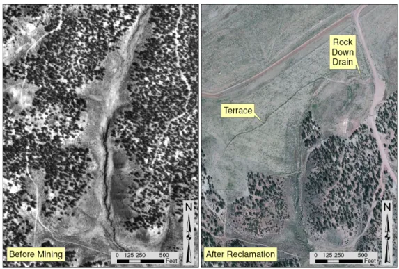
The Surface Mining Control and Reclamation Act of 1977 requires surface coal mine operators to reclaim mined lands to meet a number of requirements: (1) grade spoil piles to achieve a post-mining topography that approximates the pre-mining topography; (2) minimize the impacts on the prevailing hydrologic balance; (3) limit the contribution of additional suspended solids to receiving streams; and (4) support the proposed post-mining land uses such as livestock grazing and wildlife habitat. The reclamation activities include re-grading of spoil piles to create an approved post-mining topography including drainage networks as appropriate, replacing salvaged topsoil, re-establishing vegetation cover, and implementing erosion-control measures such as terraces and rock down drains (Figure 1).
Figure 1. The aerial photos of a coal mine area before mining (pre-mining condition) and after
reclamation (post-mining condition).
The Office of Surface Mining Reclamation and Enforcement (OSM), a branch of the U.S. Department of the Interior, is the federal agency responsible for regulating surface coal mining and reclamation activities. OSM not only reviews the reclamation plans
proposed by surface coal mine operators, but also assesses the success of surface coal mine reclamation based on performance standards. Performance standards include the
requirements to minimize erosion and loss of topsoil and limit the contribution of
additional suspended solids to receiving streams. Watershed runoff and erosion models are often used by surface coal mine operators to evaluate runoff and sediment yield from reclaimed mined lands under both pre-mining and post-mining conditions. The reclamation is considered to meet applicable performance standards if the post-mining runoff is
comparable to the pre-mining runoff, and the post-mining sediment yield is less than or equal to the pre-mining sediment yield.
Watershed erosion modeling faces two major challenges: one is to organize multiple datasets; the other is to automate the complicated workflow. To get a reliable prediction of runoff and sediment yield from a watershed, watershed erosion models should be
physically-based, and simulate a number of hydrologic and geomorphic processes significant to runoff/sediment production. All factors affecting these processes should be well represented in the model. The multiple datasets used in watershed erosion modeling include aerial photography, topography, rainfall, vegetation, soil, erosion-control measures, and the drainage network.
In addition, watershed erosion modeling has a complex workflow. First, a watershed is subdivided into a number of watershed units: hillslopes, channels, ponds, and endpoints, to reflect substantial variations in elevation, slope, soils, vegetation, land uses, etc. Second, all watershed units are assigned a unique ID and the spatial relations between watershed units (e.g., flow direction) are determined. Third, properties such as hillslope cover type and channel gradient are calculated and assigned to their corresponding attribute fields. Fourth, input files are created based on geometric characteristics and attributes, and the model is run to generate output files. Lastly, modeling results are analyzed and
comparisons are made between pre-mining and post-mining conditions.
The integration of Geographic Information System (GIS) and watershed erosion models is highly valuable to surface coal mine reclamation. The GIS technology has been widely used to organize, analyze, and display almost all spatial datasets of a watershed. The traditional way to build a watershed erosion model was cumbersome, especially when the watershed is large in area, because of manual entry of geometric and other
characteristics, lengthy analysis of modeling results in a spreadsheet, and no direct visualization of modeling results in topographic maps. The GIS-integrated watershed erosion modeling is able to calculate and populate model-input parameters and analyze model outputs without repeated work by hand.
The GIS technology has been extensively applied in numerous fields, such as
watershed hydrologic/hydraulic modeling and urban stormwater modeling, during the last two decades. GIS is used as a pre-processor to store geographic information in a
geodatabase and calculate model-input parameters from stored geographic data; and as a post-processor to deal with output files and to derive spatial statistics from modeling results. The mechanism to apply GIS in modeling has evolved from Data Interchange, to Program Interface, and to Program Integration, which were defined by Shamsi (1998). Data Interchange is a repeated process to copy files between GIS and the model. Program Interface is an automated process to transfer information between GIS and the model. Program Integration is a Graphical User Interface (GUI) where the model and GIS interacts with each other, thus being widely used nowadays.
However, little attention has been paid to the integration of GIS and watershed erosion models. Sediment routing throughout a watershed requires the simulation of complex
geomorphic processes including soil erosion, deposition, and sediment transport. In this study, we developed a GUI by integrating GIS and a watershed erosion model – EASI (Erosion And Sedimentation Impact), in order to facilitate the assessment of surface coal mine reclamation. The physically-based EASI model was developed by Ayres Associates Inc. (Zevenbergen et al., 1990; WET, 1990), was calibrated and validated in the study of RCE (1993), and has been used to predict average annual runoff and sediment yield from natural and reclaimed watersheds for Peabody Western Coal Company (PWCC) since then. More details about EASI are provided in the following section (Section 2). The integration of GIS and EASI and the product of easiTool are introduced in great detail in Section 3. The easiTool’s functionalities are demonstrated in Section 4. Finally, conclusions are made in Section 5.
2. Watershed Erosion Model - EASI
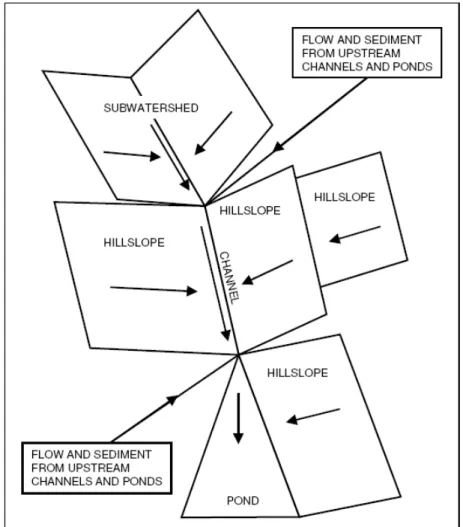
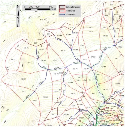
The watershed runoff and erosion modeling program, Erosion And Sedimentation Impact (EASI) was developed to aid in the analysis and development of various erosion-control practices. EASI can be used to represent and analyze a complex watershed as a network of subwatersheds, hillslopes, channels, and ponds, each with uniquely identified soil, rainfall, land-use management, and topographic or geometric characteristics (Figure 2). In EASI, a subwatershed is defined as the swale area upstream of a channel head. EASI simulated hydrologic processes such as rainfall, vegetation interception, depression storage, hillslope overland flow, channel flow, and pond flow routing, and geomorphic processes such as soil detachment by raindrop impacts or overland flow, sediment transport, and deposition. EASI calculates runoff and sediment yield for each hillslope, determines sediment transport capacity for channels and trap efficiency for ponds, and deposits excess sediment or scours channels, depending on where a sediment surplus or deficit exists.
The EASI model represents an enhanced version of the MULTSED model (Simons et al., 1978), originally developed at Colorado State University under the sponsorship of the U.S. Forest Service and Environmental Protection Agency. The development of EASI entailed numerous modifications and enhancements to MULTSED. Among other features, EASI allows for the modeling of complex hillslope geometry, incorporates level pool routing through ponds, provides flexibility in defining network connections, and includes computational algorithms to increase execution speed. The EASI model was written in FORTRAN and run in the DOS command-line environment. In addition, EASI combines a DOS-based interface to facilitate data entry and to provide limited graphical and textual representation of modeling results. Note that the DOS-based interface developed in the late 1980s is no longer user-friendly.
The EASI model was designed for the simulation of single precipitation events with low base flow in relation to storm-generated runoff. Therefore, the model is ideally suited to evaluate runoff and sediment yield in an arid to semi-arid environment, where
ephemeral streams are common. EASI has been applied in watershed erosion modeling for PWCC’s Black Mesa and Kayenta Mines in the semi-arid southwestern U.S. since the late 1980s. The model calibration was conducted using data obtained from instrumented watersheds and small hillslope plots collected under natural rainfall conditions. For details about data collection and model calibration, please refer to the study of RCE (1993).
Figure 2. Example watershed representation in the EASI Model.
3. Integration of GIS and EASI - easiTool
In order to support watershed erosion modeling with the EASI model, the GIS tool of easiTool was developed based on the ESRI ArcGIS framework. ArcGIS is widely used by surface coal mine operators to organize, analyze, and display spatial data related to
watershed erosion modeling. easiTool contains a user-friendly GUI and two underlying geodatabases that store spatial or non-spatial information in tables. The integration of GIS and EASI involved two major steps: one is to design a geodatabase that provide data structure for programming; the other is to create an interface that automates the workflow of watershed erosion modeling.
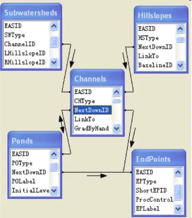
Figure 3. Five basic feature classes in the input geodatabase to store the
geometries of subwatersheds, hillslopes, channels, ponds, and endpoints. The attributes of “EASID” and “NextDownID” are used to identify watershed units and define flow direction, respectively.
Two geodatabases were designed for storing model inputs (pre-processing) and model outputs (post-processing). The geodatabase is the data storage and management framework for ArcGIS. Both input and output geodatabases belong to the type of personal
geodatabase that uses Microsoft Access database file (*.mdb) as the storage media. The input geodatabase contains a number of feature classes that store geometric information and attributes about subwatersheds, hillslopes, channels, ponds, and endpoints, all of which represents a drainage network within a watershed (Figure 2). In EASI, an endpoint is defined as the outlet of a watershed. The spatial relation between two watershed units is described by a particular attribute of a table record of either one watershed unit or the other. For example, flow direction is implemented through the attribute of “NextDownID”
(Figure 3). The attribute of “EASID” is used to identify a watershed unit in the modeling area. The input geodatabase also contains some tables storing model parameters and settings. The output geodatabase stores model results converted from model output files. As the ArcGIS geodatabase is a relational database, a number of SQL (Structured Query Language) queries were built into both geodatabases, in order to provide first-hand analyses such as the statistics of geometry.
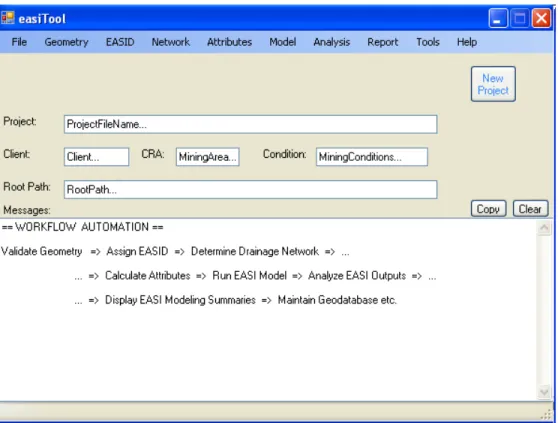
Figure 4. The main window of the easiTool interface. The workflow automation is shown in
the bottom message box.
The easiTool interface was developed using Microsoft Visual Studio 2010 and ESRI ArcObjects 10. ArcObjects, as the development platform for the ArcGIS products, is a large and powerful COM (Component Object Model) component model, which makes it easy to create domain-specific components from its basic components. By calling
functions of ArcObjects, easiTool populates geometric characteristics like length and area, calculates attributes like channel gradient and hillslope cover type, and determines spatial relations between watershed units through spatial queries. The menu strip of the easiTool interface reflects the actual workflow of watershed erosion modeling: editing geometry, assigning EASID, determining the drainage network, calculating attributes, running EASI model, analyzing EASI outputs, and reporting EASI results (Figure 4). For more details about easiTool’s menu strip and dropdown menus, please refer to the user’s manual for easiTool (Huang et al., 2011).
Note that the geometry creation has not been automated for now because (1) the engineered drainage-control measures like terraces are not easy to identify in an automatic way; and (2) the delineation of hillslopes requires a significant amount of judgment. However, geometry validation such as checking identical/overlapping units was automated in the current version of easiTool 2.3.
4. Results
Watershed erosion modeling with easiTool is much more efficient than without easiTool, based on our recent modeling work. The pre-processing for EASI was greatly improved. Firstly, easiTool is able to detect most potential problems related to geometries, although watershed units are still delineated using the Editor of ArcGIS. Secondly, as long as the geometries are created and validated, easiTool can be used to: (1) sequentially assign EASID to all watershed units based on the unit type and the location of a unit within a watershed associated with an endpoint; (2) determine spatial relations between watershed units including flow direction; and (3) calculate attributes including hillslope cover type, hillslope/channel gradient, channel cross section geometry, and stream order. Figure 5 demonstrates the creation of geometries based on topographic contours, EASID and some attributes for watershed units. The easiTool also provides options to reset EASID, spatial relation, or attributes in case that a user makes significant changes to geometries. Thirdly, all parameters about rainfall, vegetation cover, soil, and channel cross section geometry in the EASI model can be modified through a sub-window of easiTool. Lastly, easiTool creates input files for the EASI model by populating geometries, attributes, and parameters.
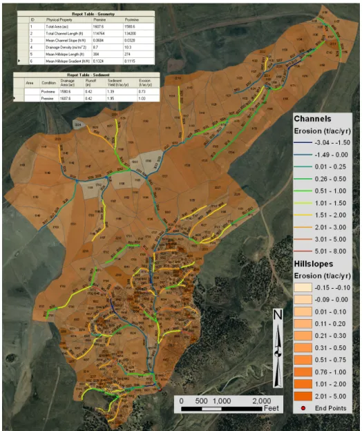
The post-processing for EASI is much more powerful than before. After easiTool starts the executable of the EASI model in the DOS environment, the model output files are generated. All output files are converted to tables in the output geodatabase. In easiTool, data analysis is conducted through sequential SQL queries, which is built-in and reusable, in the input/output geodatabase. For example, the statistics of geometry is a final query based on a series of queries related to subwatersheds, hillslopes, and channels. The query-based data analysis is more convenient and reliable than the spreadsheet-query-based data processing. Figure 6 shows two summary tables (queries): one compares the statistics of geometry between pre-mining and post-mining condition; the other compares runoff, erosion, and sediment yield. In addition, by using ArcGIS as a graphical representation tool, easiTool is able to visualize modeling results on the aerial photos or topographic maps. Figure 6 also shows the erosion/deposition pattern for an example watershed, from which a user can identify those watersheds units with excessive erosion or deposition.
The easiTool is a valuable tool to support the assessment of surface coal mine reclamation. In December 2010, Ayres Associates organized a two-day EASI Training Course for technical staff members from PWCC, OSM, and the Navajo Nation. After the training, participants found easiTool useful and productive, and valuable to further regulatory applications. A potential application is to use easiTool to evaluate revisions to proposed post-mining topography or other related aspects of a reclamation plan before implementation. In addition, the easiTool can be used to perform sensitivity analyses efficiently by revising geometries or changing input parameters. Technical staff from OSM or State regulatory programs can use the easiTool to assess reclamation plans proposed by surface coal mine operators or establish reclaimed mined lands with respect to applicable performance standards.
Figure 5. The creation of geometries for a portion of an example watershed based on
topographic contours. The subwatershed label is EASID assigned by easiTool; the hillslope label is EASID plus hillslope cover type; and the channel label is EASID plus channel stream order.
5. Conclusions
The development of easiTool greatly increases the efficiency of watershed erosion modeling through EASI due to the automation of workflow. Once all steps have been performed in easiTool, it not only compares runoff, erosion, and sediment yield between pre-mining and post-mining conditions, but also identifies those watershed units with excessive erosion or deposition. Therefore, the easiTool is a valuable for surface coal mine operators, federal regulatory agency, and state regulatory programs to assess surface coal mine reclamation. The automation of geometry creation is an important improvement in the future, which will greatly benefit watershed erosion modeling.
Figure 6. Two summary tables and erosion/deposition pattern derived from EASI models for an
example watershed. Those watershed units with excessive erosion (+) or deposition (-) can be easily located and identified through EASID. The summary tables compare the statistics of geometries and average annual runoff/erosion/sediment yield between pre-mining and post-mining conditions.
References
Huang, X., A. B. Alvarado, and L. W. Zevenbergen, 2011: User’s manual – easiTool the GIS tool for EASI version 2.3, Fort Collins, CO.
Resource Consultants & Engineers, Inc. (RCE), 1993: Surface water modeling of reclaimed parcels at the Black Mesa Complex, prepared for Peabody Western Coal Company, Fort Collins, CO.
Shamsi, U. M., 1998: ArcView applications in SWMM modeling. Chapter 11 in James, W. (ed.) Advances in Modeling the Management of Stormwater Impacts, Volume 6. Computational Hydraulics International, Guelph, Ontario, Canada. p. 219-233.
Simons, D. B., R. M. Li, and B. E. Spronk, 1978: Storm water and sediment runoff simulation for a system of multiple watersheds. Water Routing and Yield, Volume 1, Colorado State University, Fort Collins, CO. Water Engineering & Technology, Inc. (WET), 1990: Determination of background sediment yield and
development of a methodology for assessing alternative sediment control technology at surface mines in the semiarid West, prepared for the Office of Surface Mining and the National Coal Association, Fort Collins, CO.
Zevenbergen, L. W., M. R. Peterson, and C. C. Waston, 1990: Computer simulation of watershed runoff and sedimentation processes. Proceedings of the Billings Symposium: Planning, Rehabilitation, and Treatment of Disturbed Lands.