259 Brian W. Sauer1
Ronald Shurtleff2 ABSTRACT
Irrigated agriculture began in southwest Idaho’s Lower Payette Valley in the 1880’s. By 1900, over 30,000 irrigated acres had been developed, served by a system of over 20 canals diverting natural flows. High springtime river flows were often reduced to a trickle by August. Two Bureau of Reclamation dams were built to provide supplemental storage and to bring another 53,000 acres into production.
Like many early canal systems, the Payette Valley canals were built with only a few manually operated water control structures or water measurement devices. Diversions were difficult to control due to variable river flows and much water was wasted. Water rights were difficult to administer, due to the lack of accurate water measurement. In dry years there were often disputes among users on different canals as natural flows declined.
In 1997, the first canal headworks in the Payette were automated, utilizing solar power and simple off-the-shelf components. The success of this single project encouraged more irrigation entities to improve water control capabilities utilizing SCADA. New control structures were built and automated and communication links were put in place to monitor canal operations and to update water accounting.
Today, there are over 40 automated control gates, 14 telemetered water measurement sites, and 11 new water measurement structures. Diversion data daily and accurately account for water use in the basin. Telemetry has enabled canal operators to monitor facilities and to respond quickly to changing water needs or emergency situations. Canal systems in the valley are being operated more efficiently, reducing both diversion rates and operational spills. This more efficient operation has helped to improve water supply reliability. These changes have also served to bring a greater sense of cooperation to water users throughout the Payette Valley.
BACKGROUND
Early Irrigation Development
The Payette River and its tributaries drain approximately 3200 square miles in the west central mountains of Idaho (Figure 1). On average, the river produces over 2 million acre-ft of water per year. Much of the basin is unregulated, with no dams or storage
1
Hydraulic Engineer, U.S. Bureau of Reclamation, Snake River Area Office, 230 Collins Road, Boise, ID 83702, bsauer@usbr.gov .
2
reservoirs. Flows vary greatly between the peak runoff season in May and June and the lowest flow periods in August and September.
Figure 1. Map of the Payette River Basin
The Payette River was named for Francois Payette, a French-Canadian fur trapper who was one of the first people of European descent to settle in the Payette River area. Payette ventured east from Fort Astoria in 1818, and from1835 to 1844, he headed the Hudson's Bay Company's Fort Boise which was located near the mouth of the Payette River. As settlers moved into the valley in the 1870’s, irrigated agriculture sprung up along the lower the Payette Valley. Many of the farmers grew produce for the many new gold mines in the surrounding mountains.
Irrigated acreage in the valley expanded in the 1880’s as more canals were constructed. While the high elevation snow in the basin generally provided good water supplies until mid-summer, low late-summer river flows limited the irrigation development in the area.
By 1900, approximately 13,000 irrigated acres were in production. Following its creation in 1902, the U.S. Reclamation Service (later the U.S. Bureau of Reclamation) identified an additional 59,000 acres that could be irrigated from the Payette River with
construction of adequate water storage.
Black Canyon Diversion Dam, 183 ft high and completed in 1924, was the first Reclamation facility built in the Payette basin. This facility was constructed to divert water into a “high line” canal which could serve much of the remaining irrigable land on the south side of the river and to pump water to Emmett Irrigation District lands on the north side of the river. Work began in 1936 on the south-side Black Canyon Main Canal and a gravity distribution system to 28,000 acres and was completed in 1940. An
additional 25,200 new acres were added to the Black Canyon Irrigation District in 1949 with the completion of the large C-Line Pumping Plant.
Since reservoir storage was essential to expansion of irrigated lands in the Payette Valley, Reclamation then completed Deadwood Dam, a concrete arch dam with 154,000 ac-ft of storage on the Deadwood River, in 1931. Cascade Dam, a zoned earthfill dam on the North Fork of the Payette with 646,000 ac-ft of storage, was completed in 1948. The largest amounts of storage space in the two reservoirs were purchased by the Black Canyon Irrigation District (240,000 ac-ft) to irrigate the “new” project lands and the Emmett Irrigation district (62,000 ac-ft) to supplement their existing natural flow rights. These facilities, along with several smaller, privately constructed storage dams in the basin, provided stored water for late season irrigation and for the development of additional irrigated acres.
Late 1900’s Developments
Irrigation water supplies were plentiful in the Payette Basin throughout most of the1950’s and 1960’s. All of the water users had natural flow rights under Idaho’s prior
appropriation statutes and some also had reservoir storage. These rights, however, had not been formally adjudicated by the state and were not closely monitored. In some years, particularly during low flow periods in late summer, there was some friction between the two largest water users, Emmett and Black Canyon Irrigation Districts who divert their water at Black Canyon Diversion Dam, and the smaller canal companies that diverted water below the dam. Many of these “lower valley” irrigators felt that even though they had senior water rights they were sometimes short of water due to excessive diversions by the two “upper valley” users. Still, in most years, water supplies were adequate.
In 1977, much of the Pacific Northwest was subject to extreme drought conditions. This resulted in the first water shortages in the Payette Valley since the construction of Cascade Reservoir. This brought about several changes in the way water was managed. First, an emergency Payette River watermaster was appointed by the Idaho Department of Water Resources (IDWR) to monitor the irrigation diversions and to administer the water rights in the basin during the drought. This drought period also prompted two of the lower valley canal companies, the Farmers Cooperative Irrigation Company and the
Lower Payette Ditch Company, to purchase available storage in Cascade Reservoir to help weather future drought periods. Other water users, including the Noble Ditch Company and Emmett Irrigation District later purchased Cascade Reservoir storage. Shortly thereafter, IDWR began the adjudication process to formally quantify and validate all of the water claims in the Payette Basin. This process brought about further changes. Several of the lower valley canal companies filed water right claims to the irrigation return flows in the numerous open drains that carry irrigation return flows back to the lower reaches of the river. Until this time, this supplemental water was mostly taken for granted. Also, with several of the lower valley canal companies purchasing supplemental reservoir storage, a water bank was established in the Payette Basin. This enabled reservoir spaceholders to lease their unneeded stored water to other water users on an annual basis. A similar water bank had been working for many years in Snake River basin in southeastern Idaho.
Additional drought years in the early 1990’s caused more water shortages, prompting IDWR to strongly encourage the Payette water users to establish a permanent state-sanctioned water district, Water District #65, to fund a permanent watermaster to monitor all of water rights in the basin and administer the water bank. This was endorsed by the Bureau of Reclamation. By this time, Reclamation was beginning its effort to provide releases of stored water to supplement natural river flows in the Snake and Columbia Rivers for downstream migration of endangered salmon smolt. This water came from uncontracted storage in Reclamation reservoirs in the Snake River basin as well as water leased from private reservoir spaceholders through established water banks in the basin.
IRRIGATION SYSTEM IMPROVEMENTS
The drought years in the early 1990’s also caused several of the canal companies and irrigation districts in the Payette Valley to examine their facilities and operations to see where changes could be made to improve operational efficiencies. Upon reflection, several items came to the forefront. Many of the older distribution systems had limited water control capabilities and much water was lost to operational spills. In some cases, more water than necessary was diverted from the river in order to maintain adequate canal levels to make irrigation deliveries. In other cases, diversions into the canal fluctuated with changes in river flows. Antiquated or poorly-maintained headworks structures made it difficult to regulate canal inflows.
Since nearly half of the Payette River basin is not regulated by dams, flows in the lower valley can vary significantly when mountain snows are melting. These canal fluctuations often caused either too much or too little water to be delivered. Additionally, most diversions were measured using rated canal sections which “shifted” or changed
calibration during the irrigation season. This made it difficult for canal operators and the watermaster to accurately determine actual canal flows.
The First Projects
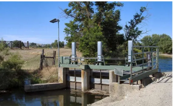
In 1996, the District #65 watermaster and representatives of the Farmers Cooperative Irrigation Company (FCIC) contacted the Bureau of Reclamation’s Snake River Area Office in Boise, ID, about some efforts by Reclamation’s Denver Technical Service Center (TSC) and Provo Area Office to develop low-cost, solar powered systems to control and monitor canal facilities. The FCIC wished to reduce operational spills by automating its “Squeeze Gate” structure which regulates flows into the company’s 30 mile-long main canal, located near Emmett, ID. FCIC applied for and received a cost-share grant from Reclamation’s Water Conservation Field Services Program for the project. With financial and technical assistance from Reclamation, the three 5’-wide x 8’ high steel slide gates were automated prior to the 1997 irrigation season.
The hand cranks on each of the three gate operators were replaced with a 30:1 chain drive and connected to a 1/10-horsepower 12-volt DC gearmotor. Power for the motors was supplied by a 30-watt solar panel and 2 deep-cycle batteries. Water level sensors were placed in the canal upstream and downstream of the structure. The system was controlled by a Campbell Scientific CR10 data logger. The data logger was connected via modem to an existing telephone line that was buried beside the canal. The site was programmed to maintain a desired downstream water level which was correlated with the canal’s gauging station another half-mile downstream of the control structure. The controller was accessed either on-site or by telephone using a laptop or desktop computer and Campbell Scientific’s PC208 software. Installation took approximately five days. Figure 2 shows the Squeeze Gate structure following SCADA installation.
Figure 2. Farmers Cooperative Automated “Squeeze Gate” Structure
After some typical startup bugs, the system worked well throughout the 1997 irrigation season. In addition to maintaining steady flows at the head of the FCIC main canal, the SCADA capabilities permitted canal operators to make flow changes remotely, saving
untold time and pickup miles. With this capability, canal flows could be changed remotely from the FCIC shop in New Plymouth, 20 miles from the site. This enabled operators to remotely make flow changes late at night which would ensure that the proper amount of water reached downstream irrigators the first thing the next morning.
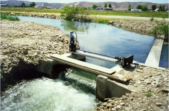
The success of the Squeeze Gate project led to other similar projects in the Payette Valley. Prior to the 1998 irrigation season, the Reed Ditch constructed a ramp flume at the head of its 50-cfs canal and replaced a check board regulating structure with an automated Armtec overshot gate (Figure 3). This site also used a CR10 controller but utilized analog cellular telephone telemetry. Also, following the 1998 season, the Lake Reservoir Company used the same technology to facilitate remote operation of three 12-ft wide radial gates at Lardo Dam in McCall, Idaho. This site, which regulates the outlet of Payette Lake, is approximately 100 miles from the Company’s office in Payette, ID.
Figure 3. Automated Armtec gate regulates the Reed Ditch diversion Types of projects
At present, there are approximately 50 SCADA sites within the Payette River valley. Individual sites may have unique configurations or operational objectives, but all use the same basic technologies, including Campbell Scientific dataloggers, solar power, and small 12-volt DC motors. The sites can be categorized as follows:
Automatic flow control - Many of the projects have established automatic and/or remote control at key water control structures. The main objective of these projects has been to stabilize and regulate downstream canal flows. To date, eight Payette River diversions, with capacities ranging in size from 30 to 1200 cfs, have been automated. This has enabled canal operators to accurately regulate canal diversions despite fluctuations in
river flows. At most locations, existing gates and operators were adapted to automatic operations with minor modifications. At one site it was necessary to replace two old wooden gates before they could be automated.
The largest automated river diversion is Black Canyon Irrigation District’s 30-ft wide radial gate at Black Canyon Diversion Dam. Due to limited freeboard in downstream flume sections, the district has installed redundant downstream water level sensors for better control and monitoring. The Emmett Irrigation District has automated the turnouts for two distribution laterals near the tail end of their main canal to compensate for
variable flow conditions.
Water level control – Several of the early canal systems were constructed with few in-line check structures. Here, the only way to regulate canal levels at delivery points was to spill water into drainage channels at various points along the canal. The Farmers
Cooperative Irrigation Company and the Noble Ditch Company have automated existing slide gates at numerous spill locations. The FCIC, the Noble and the Lower Payette Ditch Companies have replaced check boards with automated Langemann overshot gates at existing spill locations. In addition to water level control, the design of these gates also permits the companies to easily measure the spills at these sites.
In order to better control canal levels, both the FCIC and the Lower Payette Ditch Company have constructed check structures at lateral turnout locations along their main canals. The Farmers Cooperative Canal was originally constructed without control structures in the canal in order to permit logs harvested in the upper part of the Payette basin to be floated down the river and then 20 miles down the canal to a sawmill near the town of New Plymouth. During the late season when natural river flows declined and canal flows were reduced, the canal company would typically pile large rocks and concrete rubble below some turnouts to check up the water levels. The rocks were then removed after the irrigation season.
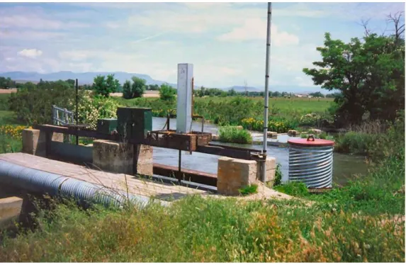
Both of the aforementioned canal companies have constructed a series of check structures to control down the length of their main canals. The checks all use a similar single overshot gate design, with the gate leaf operated by a cable hoist. Three of the FCIC’s checks have installed SCADA for automatic level control (Figure 4). The company’s remaining six overshot checks have been motorized, lacking only an RTU and
communication components to be able to operate automatically. Lower Payette has installed 7 check structures in its main canal, all motorized but not currently automated.
Figure 4. Automated check structure on the Farmers Cooperative Canal. Structure utilizes check boards (left) and automated overshot gate (right) to control water levels. Water measurement and accounting improvements – Idaho water laws require that all irrigation diversions must have some type of measurement to allow the Department of Water Resources monitor water use and assure compliance with state water rights. The state watermaster for each river basin is charged with measuring and recording water use data to determine an accurate accounting of irrigation diversions. Most of the Payette diversions were originally measured using rated canal sections which needed frequent calibration to maintain accuracy. Typically, the watermaster would only be able to visit each site once or twice a week to measure and record flows. In order to provide more accurate measurement of their diversions, several canal companies in the basin have replaced existing rated sections with ramp flumes. Since 1998, nine rated sections, ranging in capacity from 3 to 300 cfs, have been replaced by ramp flumes. At several sites, flow data from recently constructed ramp flumes is used as input for automated diversions.
The controllers at the automated sites have datalogging capability, so it is a simple matter to record flow data and obtain an accurate accounting of diversions and spills. Typically flow data is recorded every 15 minutes. Since many of the automated sites have
telephone or radio communication, the watermaster is able to download data from these sites on a daily basis via the communication link. This enables the watermaster and the canal companies to monitor their water use daily. Currently the Payette River
watermaster is able to download 15-minute flow data from 23 sites in the basin.
Downloads are performed automatically early each morning during the irrigation season. Data from 13 of these sites are used as input to the IDWR water accounting program for Water District #65.
Communications – When the SCADA installation process began, telephone technology was the primary communication method. Most of the automated sites were connected to nearby buried telephone lines. At more remote locations, analog cellular telephones were used. Most of the sites used a modem that transferred data but also could be programmed to relay information to the operator using a synthesized voice. The audio feedback was helpful to the novice SCADA system operators. They could monitor the site conditions remotely without the need for a computer. Most of the sites were programmed to automatically dial out and send an alarm to the operator in the event of certain unusual circumstances, such as high or low water levels or a non-responsive automated control gate. With voice capabilities, the operators could be informed of the nature of the problem over the phone.
In several locations, direct FM radio communications are used to transmit data between two automated sites, such as a control gate and a downstream flow monitoring site. As the number of SCADA sites increased, the water users began looking at ways to reduce communications costs. Radios were installed at some of the sites with telephone
communications, enabling those sites to communicate with new radio-only installations. This eliminated the need for an additional phone and its monthly service charges. Newer technology also enabled radio sites to serve as repeater stations for other radio sites. The remaining cell phones have been converted from analog to digital technology. However, the new digital cell modems no longer have the voice synthesis capabilities. System operators access their remote sites via office computers or with laptops and cell phone modems in their pickups.
Currently, water users in the Payette and Water District #65 are working together to develop a valley-wide radio network that will eliminate most of the telephone
communications. A radio communications site has been established at the Water District office and will also serve as a repeater site for much of the western part of the valley. The watermaster is currently working to establish another repeater site that will cover the eastern portion of the valley and can also communicate with the Water District office. The Seven Mile Slough Project
The work on one area of the Valley, the Seven Mile Slough (Slough), provides a good example of multiple water user entities working together to improve water management through the use of SCADA and improved water measurement. The Slough is a seven-mile-long side channel of the main Payette River, located near Letha, Idaho. The Noble, Reed and Letha Ditches and several smaller irrigation canals divert from the Slough. In the 1920’s the water users on the Slough constructed a concrete structure with three radial gates at the head of the Slough to regulate inflows from the river. In addition to Payette River water, the Slough can receive up to 70 cfs of water from a large open drainage channel, known locally as the Government Drain. The drain and the diversion structure, known as The Barrels, were constructed in the 1940’s by the Bureau of Reclamation to alleviate high water tables caused by upslope irrigation. The Idaho Department of Fish and Game has asked the irrigators on the Slough to maintain a minimum 35-cfs flow downstream of the last irrigation diversion.
The Noble Ditch Company (NDC) operates the Slough headworks and also has the largest irrigation diversion on the Slough. Prior to the Slough project, Noble Ditch flows were highly variable. Flow variations in the river caused variable flows into the Slough, resulting in too much or too little water being diverted into downstream canals. Variable inflows of drain water at the Barrels caused additional fluctuations in the Slough,
exacerbating the problem. All of the water control structures on the Slough were
manually operated and required constant monitoring to maintain steady canal flows. To assure sufficient water in the downstream reaches, the NDC would generally divert extra water into the Slough. Any flows above the 35-cfs minimum, however, are unused and are essentially wasted. This wasted water is charged against the water accounts of NDC and the other water users on the Slough.
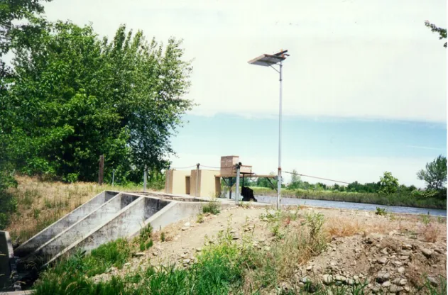
To improve the measurement accuracy on their main canal, the NDC constructed a ramp flume at the head of the Noble Ditch in 1997. Following the 1997 irrigation season, the NDC worked to automate the Noble Ditch headworks, using similar technology as the Farmers Cooperative. Utilizing financial and technical assistance from Reclamation’s Snake River and Provo Area Offices, NDC automated one of the two slide gates at the head of the ditch (Figure 5). The site was solar powered and had cell phone telemetry. Flows were measured at the downstream ramp flume.
Figure 5. Noble Ditch headworks structure
In early 1998, the Reed Ditch Company, the second largest diversion on the Slough, also constructed a ramp flume at the head of their main canal. The Reed project automated the diversion, replaced a check-board structure with a solar-powered Armtec overshot gate, and also installed cell phone telemetry. Both projects worked well during the 1998 irrigation season, and eliminated much of the variability in canal flows.
The following year, the NDC and other water users on the Seven Mile Slough tackled the problem of excess tailwater at the downstream end of the Slough. Before the 1999 season, the NDC automated two of the three radial gates on the control structure at the head of the Slough (Figure 6). A 30-ft wide ramp flume was constructed in the channel below the control structure to assure accurate flow measurement (Figure 7). The NDC also took steps to regulate inflows to the Slough from the Government Drain. A Langemann overshot gate was installed at the Barrels site to control water levels in the Drain and regulate diversions into the Slough. Another ramp flume was constructed to measure these diverted flows. The overshot design of the control gate permits
measurement of the remaining drain flows. Additionally, a second Langemann gate was installed at the last diversion on the Slough to automatically control upstream water levels and to measure flows passing back to the river (Figure 8). Cell phone telemetry permitted the NDC and the watermaster to accurately measure and control the flows in the Slough.
Figure 7. Ramp flume at the head of the Seven Mile Slough
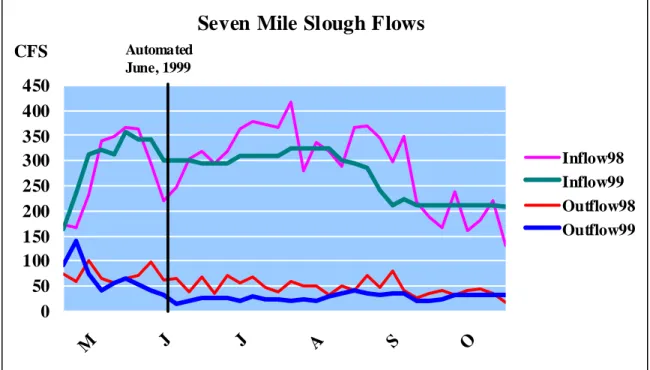
Figure 8. Langemann Gate at the last diversion on the Seven Mile Slough. These projects significantly enhanced the efficiency of the operations by reducing flow fluctuations and operational spills (Figure 9). The work done on the Seven Mile Slough demonstrated how relatively simple and inexpensive technologies could be used to improve water management in the Payette Valley. It also demonstrated how multiple entities could pull together to accomplish common objectives.
Seven Mile Slough Flows
0 50 100 150 200 250 300 350 400 450 M J J A S O Inflow98 Inflow99 Outflow98 Outflow99 Automated June, 1999 CFSFigure 9. Seven Mile Slough inflows and outflows before and after automation at the headworks and the end check.
BENEFITS
Since 1997, water users in the Lower Payette Valley have installed over 40 automated water control sites, 14 water measurement sites with telemetry, and 11 new water measurement structures. Many of these projects received technical and financial assistance from the Bureau of Reclamation’s Water Conservation Field Services Program. Some new control gates were installed in the process, but in many cases, original gates were used with only minor modifications. Nearly all of the sites are using the same technology, Campbell Scientific RTU’s, solar power, and telephone or radio telemetry.
Over the years, the RTU software and hardware has been updated and analog cell phones have been replaced with digital technology or radio communications, but the simple, “do-it-yourself” methodology has proved successful. Now, even much of the RTU
programming is being done by the water users, with some occasional outside assistance. Several of the key benefits of these projects are:
Improved water use efficiency - The SCADA and measurement improvements have reduced overall water use in the valley, primarily by providing canal operators with the tools to reduce operational waste. Comparisons of current, late-summer flows below Black Canyon Dam with historic flows show that irrigation demands in the lower valley can be met with nearly 200 cfs less water. This is primarily due to improved control and better water measurement. Better control of canal flows has also provided more constant farm deliveries, which likely has improved the efficiency of on-farm irrigation
applications. Improved water use efficiency has also helped water users to better weather the inevitable drought years.
Improved water accounting – Improved measurement of diversions and spills helps to assure accurate accounting of water use. Flumes have eliminated errors caused by calibration “shifts” of rated canal sections. Telemetry and continuous data recording allows the watermaster to provide most water users with accurate water use information on a daily basis rather than once or twice a week.
Making water available for other uses - More efficient water use has also enabled Payette irrigation districts and canal companies to make reservoir storage water available for other uses through the basin’s water bank. In years with adequate supplies, reservoir space holders can raise revenue by leasing stored water to others. In Water District #65, much of the leased water is used by the Bureau of Reclamation to augment river flows for ocean-bound salmon smolt in the lower Snake and Columbia Rivers. In 2009, Payette water users leased approximately 166,000 ac-ft of stored water to Reclamation for flow augmentation and an additional 10,000 ac-ft for in-basin irrigation uses.
Revenue for capital improvements - Lessors of water receive a payment of $2.00 per ac-ft for stored water used within the Payette basin and $11.80 for stored water used outside of the basin. (The price differential is due to in-basin leases having a higher refill priority than out-of-basin leases in the subsequent water year.) Many of the SCADA projects have been partially funded with this revenue. Additionally, Water District #65 receives a $1.00 per ac-ft administration fee for all leased water. The Water District makes most of this money available as grants for the irrigation districts and canal companies in the basin to help fund distribution system improvement projects.
Reduced operating costs – Once SCADA systems are in place, system operators are able to monitor their conveyance systems around the clock. The ability to check the status of key locations of the system at a glance and to make flow changes remotely reduces travel and man-hours. Alarm capabilities of the systems can notify operators of potential problems before they get severe and enable them to respond more quickly.
Increased cooperation – One of the unanticipated benefits of the SCADA projects in the Payette Valley has been increased cooperation between many of the canal companies and irrigation districts. As the projects were being developed, ideas and experiences were being shared among the entities. Designs for control structures and gate operators were developed and shared. As the number of sites has expanded, the water user entities have begun working together to develop a valley-wide radio telemetry network to reduce communication costs and improve the reliability. The Water District and the watermaster are a common point of contact for all of the entities and have become keys to this
SUMMARY
Irrigated agriculture has been an important part of southwest Idaho’s Lower Payette Valley for over one hundred years. Natural river flows and stored water from Bureau of Reclamation reservoirs is conveyed to over 80,000 acres of farmland through a system of over 20 canals. Most of the canal systems were constructed in the late 1800’s and were built with only a few manually operated water control structures and few water
measurement devices. Only part of the Payette River is regulated by dams, resulting in highly variable river flows. This variability made irrigation diversions into canals difficult to control. Water diverted into canals was often wasted due to the lack of accurate water measurement at diversion points and the lack of water control within the distribution systems.
A series of dry years in the early 1990’s prompted water users in the Payette Valley to evaluate updating and improving their canal systems to improve operational efficiencies. In 1997, the first canal headworks in the Payette were automated, utilizing solar power and simple off-the-shelf components. The success of this single project encouraged more canal companies in the valley to take the leap into the SCADA world. With assistance from the Bureau of Reclamation, Payette water users began to improve their water measurement and also began improving control capabilities throughout the distribution systems. New control structures were built and automated. Communication links were put in place to monitor critical locations on canals around the clock.
These improvements, initiated by a dozen different irrigation districts and canal organizations, have resulted in the installation of more than 40 SCADA sites where irrigation water is controlled and/or measured. Telemetry has enabled canal operators to monitor facilities around the clock and to respond quickly to changing water needs or emergency situations. Improved water measurement has enhanced the operators’ ability to manage their water resources. With these improved capabilities, canal systems in the valley are being operated more efficiently, diversion rates have been lowered and operational spills have been reduced. This more efficient operation has helped to
improve carryover reservoir storage and increased the amount of water made available in the basin’s water bank. Moreover, these enhancements have served to bring a greater sense of cooperation to water users throughout the Payette Valley.
DISCLAIMER
The information contained in this report regarding commercial products or firms may not be used for advertising or promotional purposes and is not to be construed as an
endorsement of any product or firm by the U.S. Bureau of Reclamation or Idaho Water District #65.