Scientific Press International Limited
Water Resources Projects in Iraq, Reservoirs in
The Natural Depressions
Mukhalad Abdullah1, Nadhir Al-Ansari2 and Jan Laue3
Abstract
Iraq had suffered for centuries from devastating floods, causing heavy life and property losses and for occasions it demolished the civilizations. Since 1950s, Iraq started to develop several natural depressions to function as escape to mitigate flood waves. The projects of this kind which had developed are: Habbaniyah project, Tharthar project, Schweicha depression and Southern Marshes. The exploitation of these projects comprises building barrages, regulators, and dykes. For Tharthar and Habbaniyah, the diverted water re-used during drought season. Although, these depressions which serve as reservoirs provide invaluable role in flood protection, the construction of the existing and future dams will reduce the feasibility of these projects.
Keywords: Habbaniyah, Tharthar, Shweicha, Southern Marshes.
1 Privat Engineer, Baghdad, Iraq.
2 Lulea University of Technology, Lulea 971 87, Sweden. 3 Lulea University of Technology, Lulea 971 87, Sweden.
Article Info: Received: October 20, 2019. Revised: November 11, 2019.
1. Introduction
Reservoirs in the natural depressions are one of the earliest irrigation projects in Iraq in the 20th century, where the main concern of the irrigation authorities in the first half of the twentieth century was to confront the flood by the most possible means and the least expensive. The pioneers in this context were the British engineer William Wilcox and British experts who Introduced studies in this tendency.
The idea is to find an escape in the shoulder of the river, in order to lead the water to a nearby natural depression. This depression utilized to maneuver in the river system operation to absorb the peak of flood waves before permeating into the Mesopotamian plain, and causing a loss of human beings and properties. Early plans had been putted in place for the implementation of the first two main projects, Habbaniyah on the Euphrates river basin, and the Tharthar project on the Tigris river basin [1]. Further, Schweicha reservoir and southern marshes were developed later to serve as the same function.
2. Habbaniyah Project
Habbaniyah project was considered for a period as the main project to protect from floods on the Euphrates River, until Haditha dam had been built. The project was proposed in the recommendations of Wilcox in 1911, but the implementation delayed due to circumstance of the First World War [2].
Studies and designs continued after the formation of the Directorate General of Irrigation to utilize Habbaniyah depression, which is located east and southeast of the city of Ramadi. Then, implementation began in 1940, and due to the political events of May 1941 in Iraq, works were stood up. During the time between the formation of the modern state in Iraq and the 1940s, the Directorate General of Irrigation deliberately creates a fracture in the opening of the (Al Sitaieh) west of the city of Khalidiya city. Where for the period from 1924 to 1942, the openings were made eight times to pass the flood waves into Habbaniyah depression which was used to absorb part of the floodwaters [3]. The development of Habbaniyah Lake was initiated again in the early 1950s as part of the recommendations of the Heigh Advisory Committee; this committee was assigned to study the development of Tigris and Euphrates river basins.[4] The implementation was carried out mainly under the supervision of Development Board, where this board commissioned in 1950 to invest the oil revenues in the development of Iraq infrastructure. The project was opened on 5/4/1956 [3].
Figure 1 shows a general map of Habbaniyah project. The project consist the followings:
1. Ramadi Barrage.
2. Warrar regulator and Warrar Canal. 3. Dhiban Regulator and Dhiban Canal. 4. Mijarrah Regulator and Mijarrah Canal. 5. Habbaniyah Lake.
6. Razzaza Lake or what is early know Abu Dibis depression.
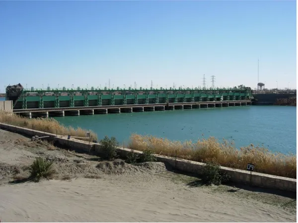
Ramadi Barrage built on Euphrates River, upstream the city of Ramadi; the structure primary function is to raise water levels that required for operation of Warrar Regulator that divert water through Warrar Canal to Habbaniyah Lake. The Barrage length is 209 m, and it consist 24 gates, their dimensions are 6m×8m, and the design discharge is 3600m3/s at level of 51.5m a.s.l. The structure includes a navigational look with dimensions of 6m× 40m and a fish ladder.
Figure 2: General view of Ramadi Barrage from the upstream side. (Source: [6]).
On the north-eastern edge of Habbaniyah Lake and Habbaniyah air base, the lake is connected with Euphrates River through Dhiban Canal, which has a length of about 9km, the discharges out of the lake is regulated by Dhiban regulator, which consists five gates with a dimensions of 4.7m×5m and a discharge of 800m3/s. Also, on the
south-eastern Edge of the lake there is Mijarrah regulator, which controls the discharge of excess water through Mijarrah Canal to Razzaza Lake. Mijarrah regulator consists 8 openings, could reach a maximum discharge of 1900m3/s [7, 8]. Regarding the lakes, the level of the bottom of Habbaniyah Lake is 36m a.s.l, and the maximum operating level of 51m a.s.l. the lake total storage is 3.28 billion cubic meters of which 2.72 billion is a live storage, while the surface area of the lake at the maximum storage level is 425km2. Pertaining Razzaza Lake or what was called
Abu Dibis or the Salt Sea, the lake role is to work as a floodwater reservoir from Habbaniyah Lake, the lake bottom level is 17m a.s.l. and the maximum storage capacity is 25.75 billion cubic meters at level of 40m a.s.l., and a surface area of 1810km2 [3].
Although Habbaniyah system has an important role to mitigate the dangers of flooding and provide water for irrigation requirements, the construction of Haditha dam and the future construction of Baghdadi dam have a negative impact on project feasibility. Habbaniyah project among the most important proposed projects at the
beginning of the twentieth century, at the time; no idea had been presented about a dam in the upper reach of Euphrates, where this had been raised during the stage of development board and the subsequent proposals of the Soviets consulting companies. One of Wilcox's proposals was also to re-use the storage of Razzaza Lake, as now Habbaniyah Lake utilized, but the detailed studies later do not recommend that.
The decline of water incomes in the Euphrates River had reflected on the water levels in Habbaniyah Lake, except the wet seasons. Also, this made a very large reduction in the limits and size of the Razzaza Lake, as shown in Figure 3 below. Finally, It's wise to mention that the drainage water of the Hussainiya irrigation project and parts of the Bani-Hassan irrigation project are pumped into Razzaza Lake.
Figure 3: Comparison of aerial photographs of the size of Razzaza Lake between 2003 and 2013.[ (Source: [9]).
3. Tharthar Project
Tharthar project is one of the strategic projects that have been carried out in order to mitigate the flood danger threating the city of Baghdad, where the frequent floods that affected the city and its residents contributed to make the issue of flood protection in Baghdad as a priority of the Iraqi government and the Directorate General of Irrigation. William Wilcox had chosen the site to be an escape to prevent flooding of Baghdad. Studies continued after Wilcox, and the implementation did not start until the establishment of the Development Board, this also coincided with the flood in 1954, which is the last flood that was sank parts of the city of Baghdad, this flood accelerated the decision to put in place the cornerstone of Tharthar Project.[3] The German company, Zublin, was entrusted to do the implementation of the structure, while Ransom and Rapier British Company carried out hydro-mechanical works. The works started in 1953, and the project was opened on 16/4/1956, where the water was passed to the Lake in the same month [7, 10]. Figure 4 shows the elements of Tharthar and Habbaniyah projects. Tharthar project consists the following:
1. Samarra Barrage.
2. Tharthar regulator and Tharthar Canal. 3. Irwayah Canal.
4. Tharthar outlet regulator. 5. Division regulator.
6. Tharathar-Tigris and Tharathar-Euphrates Canals. 7. Tharthar Lake.
In order to divert the flood waves to the Tharthar depression, it was necessary to build a barrier on the Tigris River at the city of Samarra which is Samarra Barrage; it has a length of 252m consisting of 17 openings 12m×12m of dimensions. On the right side of the barrage, a hydro-power plant were installed with 14 units, with a maximum generation of 87MW, The power station opened in 1971, there is also a fish ladder in the barrage. The maximum discharge of Samarra Barrage is 7000m3/s. The project also includes also 4 irrigation openings, with a diameter of 2.5m, these lead to underground buried pipes feed the Main Canal of the Ishaqi irrigation project.
Figure 4: Tharthar and Habbaniyah projects. (Source: [7]).
The important part of the project is Tharthar regulator, which is basically the backbone of the project to divert flood waves to Tharthar Lake, the maximum discharge of Tharthar regulator is 9000m3/s, during the flood season in 2019m there is approximately 1000m3/s passed through the regulator. The structure consist 36 openings with dimensions of 7m×12m. The regulator discharge water to Tharthar Lake via the 65-kilometer-long Tharthar canal.
In 1991, Two gates from the left of the regulator were isolated to feed the Irwaiyah Canal, which is an independent path with a discharge of 250m3/s directly connected
with Tharthar-Euphrates Canal at the upstream of division regulator. The Irwaiyah Canal is about 97km long. Figure 5 shows the satellite view of Samarra Barrage and Tharthar Regulator [7, 8].
Figure 5: Satellite view of Samarra Barrage and Tharthar Regulator (Edited by Author). (Source: [11]).
The consultants who studied the Tharthar Lake did not agreed about the reuse of the reservoir storage during drought season. However, the decision finally made to dig the canals connecting Tharthar Lake with Tigris and Euphrates rivers. Started in 1972 Tharthar outlet regulator construction begun at the southern edge of the lake, and opened in 1976, the regulator includes 6 openings with a dimensions of 6m×8m, and the maximum discharge of 1100m3/s. The bottom level of the regulator is 40m a.s.l., below that is the dead storage [3, 8, 12].
At the lower edge of Tharthar Lake, and starting from the outlet regulator. Tharthar-Euphrates Canal start in a linear path for a 26.8km till the division regulator, there, the division regulator comprised two partitions; on the left the first partition comprises 4 gates with dimensions of 8m×7m and a discharge is 600m3/s, at this regulator, Tharthar-Tigris Canal starts and confluence Tigris River upstream of Baghdad city. The other part which built perpendicular to Tharthar-Euphrates Canal has 4 gates with dimensions of 8m×7m and a discharge is 500m3/s, this regulator control the discharges on the Tharthar-Euphrates Canal which confluence with Euphrates River near Habbaniyah city. The length of the Tharthar-Euphrates Canal downstream the division regulator is 9.5km long and the water was first diverted through the canal to the Euphrates River in 1976. Tharthar-Tigris Canal continues to the east for 28.5km, at this station, the drop regulator built, the function of regulation is to control the elevations and discharges, the drop regulator includes 4 openings with dimensions of 8m×12.85m and a discharge of 600m3/s. Figure 6 is a downstream view of drop regulator. Downstream this regulator, the Tharthar-Tigris Canal continues for 36.5km. Water was diverted through the canal for the first time in 1988 [8, 12].
Figure 6: Downstream view of drop regulator on the Tharthar-Tigris Canal. (Source: [6]).
Tharthar Lake is one of the largest natural depressions in the region, where it's located west of Samarra, the lake has a pear shape with a maximum length of 120km and a maximum width of 45km. Tharthar depression is a natural feature believed to be caused due to karstification and continuous sinking of a subsurface graben. The bottom elevation of the lake -3m a.s.l, and the maximum elevation is 65m a.s.l. [3, 13]. The Lake is a natural continuation of Tharthar valley, which starts from the Sinjar Mountains, which runs north and then to the northwest, this valley drain the southeastern foothills of Sinjar Mountain, and there was a proposals about utilizing the catchment and harvesting the water in the valley before reaching Tharthar Lake, unfortunately; there were no measuring station for this promising valley. Nevertheless, an estimation during the rainy season 2012-2013 revealed that the upper reach of the valley before the confluence with Tharthar Lake has income about 141.7 million cubic meter at that season [14].
Tharthar Lake maximum capacity is 82 billion cubic meters at the level of 65m .a.sl. The water has been diverted for many years, and the rate of incomes of the lake had been decreased after the commissioning of Mosul dam, and will decrease further after the building of Bekhme and Makhoul Dams.
Ones of the main issues in Tharthar Lake are the evaporation and high salt content. The surface area of the lake is 1600km2 at the bottom level of outlet regulator which
is 40m a.s.l., it rising to 2700km2 at the operational maximum level 65m a.s.l., also,
evaporation at the maximum capacity is 7.4 billion cubic meter per year. Additionally, the high rate of evaporation, causes high saline concentrations of water in the lake, this is also caused mainly due to saline leaks from the bottom of the lake. The Directorate General of Industry analyzed water samples from Tharthar Lake when it was first started in operation. It was estimated that the lake had had a solution close to the saturation level before opening the canal for the first time in 1956 where the estimated quantity was 100 million cubic meters. After closing the canal after the first flood water passing, where it was closed on 5/5/1956, and after 24 days of closure, the salts concentration was 3.700ppm, this increased on 20/11/1956 to 9360ppm. After calculating the evaporation salts residual, it was concluded that the solubility of salts from the lake bed, most of which is sodium chloride, is the largest source of salinity in Tharthar Lake.[15]
Energoprojekt company conducted in 1971, a study to analyze the salt balance within Tharthar Lake after thirteen years of commissioning, i.e; the period of 1957-1969. The results manifested that the evaporation from the lake is an additional factor affecting the salt accumulation, as the major contributor is the solution of the salts from the Lake bed. Table 1 shows an approximate contribution of various factors in increasing salt concentration within Tharthar Lake [16].
Table 1: An approximate contribution of various factors in increasing salt concentration within Tharthar Lake [16].
Salt balance in ThartharLake Water capacity billion m3 Total quantity of salt Concentration ppm % Old Tharthar depression till Jan., 1, 1957. 1.5 15.200 220 14.7 Diverted Tigris river from Jan., 1, 1957 to Dec., 31, 1969. 68.6 17.200 250 16.7 Evaporation losses during 13 years period 30.6 7.600 100 6.7
Bed and wall of depression lixivation from Jan., 1, 1957 to Dec., 31, 1969. - 65.000 930 61.9 Salt in the Tharthar Dec., 31, 1969. 70.1 105.000 1500 100
Another aspect of Tharthar Lake is the proximity of the inlet mouth to the outlet regulator. This is reflected negatively on the mixing and the homogeneity of salt concentrations in the lake [17].
The years of drought that Iraq had experienced in 1999 and 2001, and after reaching the level of the lake below the bottom of the outlet regulator, the proposal of installing a pumping station to use the dead storage was presented. This idea was raised again after the dry season 2018, but the pumps did not install yet, although preparation works was partially completed.
4. Shweicha Depression
Shweicha depression is located east and northeast of Kut city, with the following main valleys feeding the depression: Wadi Harran, Wadi Shushrin, Wadi Al-Obeid, Wadi Tarsakh and Wadi Badra. The highest discharge achieved by these valleys is in the Wadi Badra where it reached 3500 m3/s [18].
The depression bordered from the west by the chordal dykes that protects the city of Kut and Baghdad-Kut highway, the depression expands from the eastern side to some limits depending on season.
The idea of exploiting this depression was started at the beginning of the recommendations of the irrigation projects in the Wilcox proposals and the subsequent British consultants. Where the first idea was to divert part of the flood of the Diyala River, in addition to what flows from the floods of the eastern valleys and highlands from the Iranian side. These proposals have not been put into practice. The projects currently being built on the Diyala River are already has shortage in supply. Nevertheless, the depression continued to store water coming from the tributaries and discharge the water to Tigris river through Um Al-Jerie regulator which has a capacity to discharge 25m3/s. In addition, Nishama Escape also has a discharge capacity of 50m3/s, where this escape operates at a specific level during the high storage. Shweicha depression is widely spread and has a low height with a high rate of evaporation; the bottom level is 12m a.s.l., and the maximum storage elevation is 15.4m a.s.l. Estimates of storage are varying due to the lack of clear boundaries as well as sediments, however, the estimates indicate that they range from 400 to 500 million cubic meters. The depression also is a threat to the city of Kut in the event of collapse of the surrounding dykes on the west. The reservoir is important to supply irrigation requirements downstream Kut Barrage as well as improving navigation on the Tigris, putting in mind to utilize the storage in the same season in order to avoid evaporation losses. There is also a possibility of increasing the capacity of the reservoir by raising the western embankments. Finally, the case of development of Shweicha depression has a lack of sufficient data and comprehensive study of the area.[19][20]
5. Southern Marshes
The marshes are one of prominent geographical features of the sedimentary plain. Figure 7 show a satellite view of Southern Marshes. Marshes area had shrunken often for multiple reasons, which are; the agricultural exploitation, the use of some as a balancing reservoir for the main drains, urban expansion, oil exploration as example in the eastern parts of Hammar marshes, security and military reasons, and the most important reason is the decrease in water quantities due to the riparian countries policies, especially after the 1990s. Areas occupied by marshes had compensated with the development of land for agricultural exploitation. That proposal of land reclamation had been raised earlier by British Consultants, namely; Heigh Commission, before the era of Development Board [4]. After 2003, the policy of the Ministry of Water Resources changed to re-flood the marshes for livestock development, tourism and environmental purposes [21]. The role of marshes in flood control and the southern marshes resemble a survival system to the main cities in the south, especially Amarah city. Also, it is noted that there is no accurate and confirmed monitoring of the marshes, but only estimates. The area varies widely between the drought seasons and flood seasons due to the high rate of evaporation and the low depths.
Although several promising studies after 2003 were made pertaining re-flooding the southern marshes, where conclusions presented that re-flooding marshes will create invaluable opportunities in the socio-economic development, but none of these had made a proof in reality. Hence, Re-evaluating the southern marshes land and water use efficiency is very important, deeming the water income decrease, climate change, food security, water security, and achieving positive socio-economic impacts based on representative depiction.
Figure 7: Satellite view of Southern Marshes. (Source: [22]).
There are three major marshes containing smaller marshes inside, which are:
5.1 Hawizeh Marshes
Hawizeh is the largest marshes, it's located in the province of Maysan on the left Tigris River, it's also a joint marsh with the Iranian side, and the major feeder of Hawizeh Marshes is Karkheh River, which originates from the Iranian side. Hawizeh Marshes area varies between 2500 and 1250km2 between Iraq and Iran.[23] The exploitation by the Iranian side of the Karkheh River has reduced the area of Hawizeh Marshes. To drain water of these marshes, it effluent the water to the Tigris and Shatt Al-Arab through the Regulators, in order to maintain the water levels inside the marshes, these regulators are:
1. Kassara/Hawizeh regulator: to discharge water to Tigris River, this regulator is located near the city of Ezir. It consist 3 openings with dimensions of 2m×2m, and a side spillway of 65m long, regulator discharge is 120m3/s. 2. Swaib regulator: to discharge water to Shatt Al-Arab, this regulator is
located near the city of Quran. It consist 4 openings with dimensions of 2m×2m, and a side spillway of 140m long, regulator discharge is 200m3/s.[8] In order to mitigate the flood of Tigris River at the city of Amara, Kumait escape regulator constructed in the 1990s, which is located on the left bank of the Tigris
River at 5km upstream of Kumait city. The Regulator consisting 27 openings with a width of 3.5m and a discharge of 400m3/s [24]. The regulator discharges the water to Sannaf marsh, which is connected with Hawizeh Marshes. Figure 8 is an upstream view of Kumait regulator.
Figure 8: Upstream view of Kumait regulator. (Source: [6]).
5.2 Central Marshes
Central marsh also called Qurnah Marshes, it's located within the provinces of Maysan, Basra and Dhi qar between the Euphrates and Tigris Rivers. Central marshes mainly connected with some branches of Tigris River on the right. The Central marshes area varies from 2350 to 250 km2 [23]. The most important flood
protection escape connected with the central marshes is Musandag flooding escape, which lies to the right of Tigris River. Musandag escape diverts water through Musandag flooding course. Further, the flood waves are dissipated through Buteirah route, this route begin about 15km upstream of Amarah city, the discharges to the route controlled by two regulator, namely; Buteirah and Eraidh, for both the design discharge is 700m3/s, while the route capacity is much less. During high floods, the Central Marshes overflow the Euphrates River, and connected with Hammar Marshes. The Central Marshes drained through several openings to Euphrates River, one of the most important of them is the outlet of Ezz River.[8][25]
5.3 Hammar Marshes
These marshes located on the left of Euphrates River, connected with several branches downstream the city of Suq Al-Shuyukh. The surface area varies between 1650 to 595 km2 [23]. The end of the Hammar Marshes is linked to the Shatt Al-Arab in Grmat Ali, which is the ancient course of the Euphrates River. Dykes had been constructed to isolate the parts of Basra province from that of Dhi Qar province, the purposes of this is to protect oil facilities and to reduce salt concentrations in Shatt al-Arab.
6. Conclusion
Several natural depressions across Iraq were utilized to act as reservoirs that absorb peak of flood waves. The below conclusions could be drawn:
1. Reservoirs in the natural depressions played an important role in flood risk mitigation. This task will be a very important future function even with a less frequently flood occurrence.
2. The commissioning of the existing and future dams will make less the feasibility of the natural depression reservoirs.
3. Tharthar Lake bed is one of the major sources of salinization in the flow of Tigris and Euphrates. Hence, completing the large dams in the northern of Iraq has a vital importance to conserve the water quality.
4. Southern Marshes has a major role in flood protection of the southern cities, but it's required that re-flooding to be based on tangible socio-economic and engineering impacts.
References
[1] Wilcox, W (1917). Irrigation of Mesopotamia.
[2] Sousa, A. (1944).Euphrates Basin, and Habbaniyah Lake Project (in Arabic). [3] Sousa, A. (1966). Baghdad Floods in the History: Volume 3 (in Arabic). [4] Commission I.D.C. (1951). Heigh The Control of the Rivers of Iraq and the
Utilization of Their Waters.
[5] Board, D. (1955).The Habbaniyah Scheme.
[6] Resources, M. of W. Ministry of Water Resources Official Page on Facebook Available online: https://www.facebook.com/waterresources2/?__tn__=kC-R0.g&eid=ARB_vikp82C0hDpmLSD5DywN37xKMKk8imYIn2PhYPeUh2
KW2Kj_a4mh-PBME0E2_ymGK4R0-TzxN71H&hc_ref=ARTjh7GWKUgcCsFz1D3H1C92eUW9dbL4UdO_cA_ vttchORbUsIHWsOhQy4rbVssSgrk&fref=nf&__xts__[0]=68.ARAJtjsqk9j7 gRAv (accessed on Jun 14, 2019).
[7] Resources, M. of W. (2005). The Encyclopedia of Irrigation in Iraq, February 1918-February 2005.
[8] AL-Simawi, H. (2014). Irrigation Regulators in Iraq until the end of the year 2013.
[9] Iraq, N. (2013). Razzaza Lake ( IQ058 ).
[10] Board, D. (1956). Development Board Publication.
[11] Esri ArcGIS Online Available online: Figure 5%22 shows the satellite view of Samarra Barrage and Tharthar Regulator. (accessed on Jun 13, 2019).
[12] Construction, R.C. for D. Flood Wave of Tharthar-Euphrates Main Regulator (in Arabic) (1989).
[13] Sissakian, V. (2011). Genesis And Age Estimation Of The Tharthar Depression, Central West Iraq. Iraqi Bull. Geol. Min.7, 47–62.
[14] Saleh, S.A. (2017). Abdulrahman, O.R.; Salih, A.M. Innovated Method to Estimate the Water Income in the Section of Tharthar Valley near the Site of Hatra Proposed Dam. 22, 88–102.
[15] Industry, D.G. of Tharthar Salinity (1957). A Report Submitted to Development Board.
[16] Consulting Engineering Burau (2011). University of B. Lakes Testing.
[17] Al-Ta’i, M. (2015). Effect of Influent Point of Atharthar Lake on the Distribution of Water Quality, Baghdad.
[18] Saeed, F.H. (2018). Optimum Utilization Of Iraqi Eastern Streams. In Proceedings of the water scarcity in Iraq, current situation and future challenges. Iraqi Forum for Intellectuals and Academics.
[19] Sousa, A. (1947). Major Irrigation Projects: The Reservoir of Shweicha Marsh. [20] Hachim, A.H.(2018). Nishama Escape (Unpublished, in Arabic).
[21] Iraq, N. (2014). The new Eden project: Executive Summary 2003-2013. [22] Wikipedia Mesopotamian Marshes Available online:
https://en.wikipedia.org/wiki/Mesopotamian_Marshes (accessed on Jun 13, 2019).
[23] Hassan, K.H. (2006). Geographical Analysis of Drained Marshes in Southern Iraq (in Arabic). Dhi qar Univ.
[24] Zubaidy, R.Z. Al, Thamiry, H.A., Al; Khafaji, S., Al. (2016). Developing Flood Discharge Capacity of Kmait River.
![Figure 1: Habbaniyah project, a general map. (Source: [5]).](https://thumb-eu.123doks.com/thumbv2/5dokorg/4268866.94644/3.813.104.703.273.678/figure-habbaniyah-project-a-general-map-source.webp)
![Figure 3: Comparison of aerial photographs of the size of Razzaza Lake between 2003 and 2013.[ (Source: [9])](https://thumb-eu.123doks.com/thumbv2/5dokorg/4268866.94644/5.813.107.706.375.709/figure-comparison-aerial-photographs-size-razzaza-lake-source.webp)
![Figure 4: Tharthar and Habbaniyah projects. (Source: [7]).](https://thumb-eu.123doks.com/thumbv2/5dokorg/4268866.94644/7.813.109.698.120.733/figure-tharthar-habbaniyah-projects-source.webp)


![Table 1: An approximate contribution of various factors in increasing salt concentration within Tharthar Lake [16]](https://thumb-eu.123doks.com/thumbv2/5dokorg/4268866.94644/10.813.122.693.567.1016/table-approximate-contribution-various-factors-increasing-concentration-tharthar.webp)
![Figure 7: Satellite view of Southern Marshes. (Source: [22]).](https://thumb-eu.123doks.com/thumbv2/5dokorg/4268866.94644/13.813.109.706.108.555/figure-satellite-view-southern-marshes-source.webp)
![Figure 8: Upstream view of Kumait regulator. (Source: [6]).](https://thumb-eu.123doks.com/thumbv2/5dokorg/4268866.94644/14.813.110.705.211.548/figure-upstream-view-kumait-regulator-source.webp)
