V¨
aster˚
as, Sweden
Thesis for the Degree of Master of Science in Engineering
-Dependable Systems 30.0 credits
APPLYING UAVS TO SUPPORT THE
SAFETY IN AUTONOMOUS
OPERATED OPEN SURFACE MINES
Rasmus Hamren
rhn15001@student.mdh.se
Course: FLA500
Examiner: H˚
akan Forsberg
M¨
alardalen University, V¨
aster˚
as, Sweden
Supervisors: Baran C
¸ ¨
ur¨
ukl¨
u
M¨
alardalen University, V¨
aster˚
as, Sweden
Company supervisor: Stephan Baumgart,
Abstract
Unmanned aerial vehicle (UAV) is an expanding interest in numerous industries for various ap-plications. Increasing development of UAVs is happening worldwide, where various sensor attach-ments and functions are being added. The multi-function UAV can be used within areas where they have not been managed before. Because of their accessibility, cheap purchase, and easy-to-use, they replace expensive systems such as helicopters- and airplane-surveillance. UAV are also being applied into surveillance, combing object detection to video-surveillance and mobility to finding an object from the air without interfering with vehicles or humans ground. In this thesis, we solve the problem of using UAV on autonomous sites, finding an object and critical situation, support autonomous site operators with an extra safety layer from UAVs camera. After finding an object on such a site, uses GPS-coordinates from the UAV to see and place the detected object on the site onto a gridmap, leaving a coordinate-map to the operator to see where the objects are and see if the critical situation can occur. Directly under the object detection, reporting critical situations can be done because of safety-distance-circle leaving warnings if objects come to close to each other. However, the system itself only supports the operator with extra safety and warnings, leaving the operator with the choice of pressing emergency stop or not. Object detection uses You only look once (YOLO) as main object detection Neural Network (NN), mixed with edge-detection for gaining accuracy during bird-eye-views and motion-detection for supporting finding all object that is moving on-site, even if UAV cannot find all the objects on site. Result proofs that the UAV-surveillance on autonomous site is an excellent way to add extra safety on-site if the operator is out of focus or finding objects on-site before startup since the operator can fly the UAV around the site, leaving an extra-safety-layer of finding humans on-site before startup. Also, moving the UAV to a specific position, where extra safety is needed, informing the operator to limit autonomous vehicles speed around that area because of humans operation on site. The use of single object detection limits the effects but gathered object detection methods lead to a promising result while printing those objects onto a global positions system (GPS) map has proposed a new field to study. It leaves the operator with a viewable interface outside of object detection libraries.
Keywords— Object Detection; You only look once (YOLO); Unmanned aerial vehicle (UAV); Sit-uational Awareness; Critical situations; Autonomous vehicle; Critical Global Positioning System (GPS) mapping
Sammandrag
Dr¨onare blir allt mer anv¨anda i m˚anga branscher f¨or de m¨ojligheterna till olika anv¨andningsomr˚aden. Mer och mer utveckling av dr¨onare g¨ors d¨ar olika sensorer och funktioner l¨aggs till, d¨ar multifunktionella dr¨onare kan anv¨andas inom omr˚aden d¨ar de inte har flugit tidigare. P˚a grund av deras tillg¨anglighet, l˚aga kostnad och flygv¨ardighet ers¨atter de dem dyra system som helikopter¨overvakning och flyg¨overvakning. Dr¨onare anv¨ands ocks˚a f¨or ¨overvakning d˚a de l¨att kan kamma av omr˚aden, ge information till f¨orem˚ als-avk¨anning f¨or video¨overvakning och dr¨onarnas r¨orlighet g¨or det l¨att att hitta ett f¨orem˚al fr˚an luften utan att st¨ora fordon eller m¨anniskors som ¨ar p˚a marken. I denna avhandling l¨oser vi problem genom att anv¨anda dr¨onare p˚a autonoma omr˚aden, hittar objekt genom f¨orem˚alsavk¨anning och motverkar kritiska situationer. Genom att st¨odja webbplatsoperat¨orer med ett extra s¨akerhets lager, tack vare dr¨onarens kamera, kan vi h¨oja s¨akerheten inom dessa omr˚aden. Efter att ha hittat ett objekt p˚a en s˚adant omr˚ade anv¨ands GPS-koordinater fr˚an dr¨onaren f¨or att se vart objektet befinner sig och sedan placera det detekterade objektet p˚a en 2D-karta. Koordinater ber¨aknas f¨or de detekterade objekten, och kartan visas f¨or operat¨oren, som kan se vart objekten befinner sig, och se om kritiska situationen kan uppst˚a. Direkt under objektdetekteringen kan kritiska situationer rapporteras p˚a grund av att s¨akerhetsavst˚anden bryts, som ger varningar om objekt skulle komma f¨or n¨ara varandra. Systemet st¨oder dock endast operat¨oren med extra s¨akerhet och varningar, vilket l¨amnar operat¨oren till att g¨ora valet om att trycka p˚a n¨odstopp eller inte, vid en f¨ormodan kritisk situation. Objektdetektering anv¨ander f¨orem˚alsavk¨anningsn¨atverket YOLO som huvudobjektdetektering, som ¨ar ett neuralt n¨atverk, blandat med kantdetektering f¨or att ¨oka noggrannheten under f˚ agelperspektiv-filmning, och ¨aven st¨od av r¨orelsedetektering f¨or att hitta alla objekt som r¨or sig p˚a plats, ¨aven om YOLO kan inte hitta alla objekt p˚a omr˚adet. Resultatet visar att UAV-¨overvakning p˚a autonoma platser ¨ar ett utm¨arkt s¨att att h¨oja s¨akerheten inom ett omr˚ade om operat¨oren exempelvis skulle vara ofokuserad, eller att hitta objekt p˚a omr˚adet f¨ore start. Operat¨oren kan d˚a flyga med dr¨onaren runt p˚a omr˚adet och skapa en extra s¨akerhets˚atg¨ard f¨or att hitta m¨anniskor p˚a plats f¨ore start. M¨ojligheten att ocks˚a flytta dr¨onaren till en specifik plats, d¨ar extra s¨akerhet beh¨ovs, skapar h¨ogre s¨akerhet f¨or operat¨oren genom att se och f˚a infor-mation om omr˚adet, och sedan kunna ta ett beslut om exempelvis begr¨ansa autonoma fordonens hastighet runt det omr˚adet p˚a grund av m¨anniskors verksamhet p˚a just den platsen. Anv¨andningen av objektdetek-tering med enstaka metoder begr¨ansar effekterna men flera kombinerade objektdetekteringsmetoder leder till ett lovande resultat. Objekt markeras p˚a en GPS-karta, som inte har gjort tidigare, vilket skapar ett nytt f¨alt att studera. Det l¨amnar operat¨oren med ett bra gr¨anssnitt ut¨over objektdetekteringsbiblioteken.
Acknowledgement
This thesis would not have been possible without Volvo CE, and I can not express my gratitude enough for the opportunity my supervisors Stephan Baumgart and Baran C¸ ¨ur¨ukl¨u have been given me. I would not have accomplished this thesis without my supervisor, Volvo CE as company or software platform manager Andreas Deck. Without all of you, I would not have achieved my result or been able to try the opportunity to research within object detection category and safety layer assessments.
I also want to thank Nordic Electronic partner (NEP) for material such as FLIR-camera, and by this given me more inputs to prove my research. I also want to thank NEP for help, such as report-startup, office at MDH, and other support.
List of Figures
1 Fault reaction time figure gives the operator time to see a potentially critical situation, to press the emergency stop. . . 2
2 The object detection of Volvo autonomous solutions machinery, TA15, using NN pretrained
YOLOv4-weight file. . . 5
3 Control Structure of TA15 (HXn), giving the information that a TA15 is both autonomous
within the fleet control or the site server and radio-controlled from the remote operator. . . 5
4 Quarry Site Automation - Electric Site Example, giving the information about how an
au-tonomous site and machinery work in fleets, and charging abilities to sustain an auau-tonomous site always running with assignments and operations. . . 6
5 Example of a CCTV operator, where the operator sits and watches all the CCTV screens
at once to sustain the safety on site, using two different methods: overview map of the autonomous vehicle and camera surveillance on site. . . 7
6 Flow of method from Research question and problem to functional implementation. . . 10
7 Basic structure of the implementation. . . 13
8 Gridmap where blue square is the UAV and the reds squares are the detected objects.
Straight upward is the North, while left is west, right east and down south. The compass angle from the UAV will be used to referee where the object are referring to the UAV. This is being static in the gridmap code, appendix C . . . 14
9 Usage of pixel and height, giving information about how to use the camera angle, UAV
height, UAV coordinates and the detected object. The only missing variables then is the distance to object, being calculable. . . 15 10 Overview of objectdetection.py-code, appendix A with preparation-of-image focus. . . 16 11 A visual figure about how the camera angle works for the UAV. bird-eye view is zero degree
angle, while straightforward view is going to 90 degrees angle. . . 17
12 2D-view how to measurement the angle to the object, UAV perspective. . . 18
13 Overview of object detection with YOLO and Edge detection, and how the object detection
frameworks proceed with the image extruded from videos or streams. . . 19 14 Basic overview of motion detection. . . 20 15 Basic overview of how the gridmap system works. . . 22
16 Person and TA15 (Truck), predicted situation, person in blind-spot, Weight:YOLOv4. . . . 24
17 Installation manual published GitHub . . . 25 18 Motion detection running showing off error that can be implicitly in motion detection object
detection. . . 27
19 Comparing between object detection where tiny YOLO found more object but no humans
and had lower accuracy comparing to v4. Also viewing edge-detection in bird-eye-view. . . 27 20 Viewing the safety circles, buffering when object has not been detected. . . 28 21 Comparing all runs pointed on gridmap, same video input. . . 28 22 IR heat detection, circled around humans. . . 34
Glossary
CCTV Closed Circuit Television AOZ Autonomous Operating Zone UAV unmanned aerial vehicle VAS Volvo autonomous solutions YOLO You only look once
CNN Convolutional neural network
R-CNN Region-Based Convolutional Neural Network, Object detection Neural Network OS Operative system
ISO International Organization for Standardization MSAR Marine search and rescue
IR Infrared
FPS Frames per second NN Neural Network
GPU Graphical Process Unit CPU Central Process Unit GPS Global Positioning System WSL Windows Subsystem Linux FLCC Flight Control Computer
Table of Contents
Glossary v
1. Introduction 1
2. Background 2
2.1. Unmanned Areal Vehicles (UAV) . . . 2
2.2. Critical situations . . . 2
2.3. Machine Learning . . . 3
2.4. Object detection using camera picture with UAV or CCTV . . . 3
2.5. Neural Network . . . 3 2.5.1 Object detection . . . 3 2.5.2 Datasets . . . 4 2.6. Masking . . . 4 2.7. Programming language . . . 4 2.7.1 Python . . . 4
2.7.2 Operative system (OS) . . . 4
2.8. Standards . . . 4
3. Industrial Case 5 3.1. TA15 - Autonomous machine . . . 5
3.2. Application Scenario . . . 6 3.3. Camera Surveillance . . . 7 3.4. Identifying hazards . . . 7 4. Related Work 8 4.1. Object detection . . . 8 4.2. Object of Interest . . . 9
4.3. Neural network frameworks . . . 9
4.4. OpenCV . . . 9 5. Method 10 5.1. Proposed Structure . . . 10 5.1.1 Research Problem . . . 10 5.1.2 Research Questions . . . 11 5.1.3 Research Methods . . . 11 5.2. Evaluation . . . 11 5.3. Limitations . . . 12 6. Implementation 13 6.1. Process of system, basic overview . . . 13
6.2. Calculation basis for gridmap . . . 14
6.3. Preparation of image . . . 16 6.4. Data inputs . . . 17 6.4.1 Camera angle . . . 17 6.4.2 Equations . . . 17 6.4.3 Angle to object . . . 18 6.5. Object detection . . . 19 6.6. Motion detection . . . 20
6.7. Object positioning and position-mapping . . . 22
6.8. Application . . . 23 6.8.1 Preparation of Image . . . 23 6.8.2 Object Detection . . . 23 6.8.3 Situation . . . 24 6.8.4 Installation . . . 25 7. Results 26
8. Discussion 29
8.1. Ethical and Societal Considerations . . . 30
8.2. Reliance on support functions . . . 30
9. Conclusion 31 9.1. Research Question . . . 31 9.2. Implementations levels . . . 32 9.3. Future work . . . 32 9.3.1 System of systems . . . 33 9.3.2 Path planning . . . 33
9.3.3 Open source UAV . . . 33
9.3.4 Masking . . . 34 References 37 Appendices 38 A Object detection 38 B Motion detection 45 C Gridmap 48
1.
Introduction
Unmanned aerial vehicle (UAV) are growing importance in many industries for various applications. In the past, unmanned aircraft circled the sky mostly to support with photographically images [1] for military purposes. While balloons and airplanes have been expensive and not affordable for private users, small drones’ development made it possible to own drones with cameras and sensors privately. From balloons to airplanes, from paper planes to own private drones, development from the basics to more advance UAVs than ever before, with cameras and sensors to support tasks and other more complex usages, such as agriculture usage and human saving operations.
UAVs are replacing expensive systems, such as helicopters to record videos, movies, or other replace-ment where complexity and cost have been limiting factors. UAVs fly autonomously and deliver, for example, package [2] or collect agricultural data [3]. Another application scenario is using object detection in images to sustain a safe environment for humans.
Many of today’s commercially available drones are equipped with cameras as the primary sensor. This requires object detection algorithms to identify and track predefined and relevant objects. The advantage of UAVs is that they are flexible in their areal application. In Maritime Safe and Rescue (Marine search and rescue (MSAR)) operations, where humans at risk need to be located quickly in large maritime areas, a fleet of UAVs can support the rescue teams with scanning for the humans to rescue [4]. It is necessary to reliably identify objects and provide feedback to determine which area the rescue operation should focus on. Additional sensors like Infrared (IR) or enhanced algorithms can improve the object localization and tracking results.
Apart from autonomously operating UAVs, automating systems are considered in many domains. While automated cars operate as a single unit, transport solutions for goods require connected automated systems. In the earth moving machinery domain, autonomous vehicles for transporting material in open surface mines are developed, such as in the Electric Site research project by Volvo Construction Equipment [5]. In this project, a fleet of up to eight autonomous haulers has been used to transport rocks in a Skanska quarry site. While human operated machines do not require advanced monitoring, a fleet of autonomous machines must be monitored to catch potential critical situations in time. This monitoring of many moving vehicles from a control room utilizing, among others, the video feed from static cameras located at the quarry site is challenging and tiring for humans. There is a risk that critical situations are overseen, and operators react too late. It is interesting to investigate how a drone can support the human operator to identify critical situations in this context.
This thesis investigates how to implement additional monitoring features to improve overall safety on the autonomous site, where finding humans before startup is one of the tasks. During autonomous operation of the site, UAVs can support identifying unauthorized humans and report this to the site operator since this situation is potentially critical. One entry point is to examine how a UAV can be applied to support other monitoring features and support site operators with identifying critical situations. To provide additional monitoring features of using a UAV on site, appropriate data extraction algorithms need to be identified and evaluated. Robustness and reliability are essential characteristics such an algorithm shall provide to enable the application in safety critical use cases. Since autonomous vehicles, humans, and other vehicles are likely to move; the object detection must be capable of detecting and tracking movable objects, the camera feed of the UAV. This shall be reported to a 2D grid map to mark critical areas for the site operator. Providing proof of concept will be the main focus during the implementation part. Using videos from the UAV and support object detection, data extrusion, GPS coordinates, and other essential data, will be the main inputs to prove using this system as an additional safety layer for ensuring a safe operation of the fleet of autonomous vehicles.
Different Convolutional neural network (CNN), such as R-CNN, Fast R-CNN, Mesh R-CNN, RFCN, SSD, and different versions of You only look once (YOLO), are candidates for object detection, but only one is used to sustain the system with accurate neural network object detection, and proving the system with object detection neural network. Proof of using multiple object detection methods will be realized and overwhelm a higher accuracy than using only one method. You only look once (YOLO) is the used neural network within this thesis, with other object detection methods aside such as; moving detection and edge detection, encourage higher accuracy of finding an object on site. IR is discussed and tested on site but never implemented into the developed system.
The thesis is structured as follows. In section 2., the background of this thesis is described, including details on safety critical systems. The industrial case we study in this work is explained in section 3. In section 4., we discuss the related work relevant to this research. The research questions and applied
2.
Background
This section presents the background for this thesis, which contains an introduction to safety-critical systems, object detection methods, and image detection algorithms.
2.1.
Unmanned Areal Vehicles (UAV)
An UAV is an unmanned flying vehicle, where the main focus is to have non-humans on board, doing task either autonomously or radio-controlled. UAVs is being adopted more and more to the military since its support of doing a task without interfering physically on site. UAVs also gets used more and more since its usage in the private industries were taking pictures and flying has been a main area of usage. Races are being held between users, and hobby-photographers use UAV to take helicopter-like pictures. UAV is being called drone in many contexts outside of the area och technical industries, and engineering [6]. [7].
UAV can be controlled using radio control or can be run autonomously [8], where the ground role of a UAV is that is shall always be unmanned. UAVs are equipment that can have a different purpose and can be used in the military [9], or task such as object detection [10]. UAVs can also be used in assignments were making it easier for humans, such as spraying field to protect people from malaria [11]. This proves the multipurpose of UAVs. The information gathered is that the object detection system may be used on Volvo autonomous site since the multipurpose in different application areas.
2.2.
Critical situations
Critical situations state a problem to solve, where a situation is accruing between vehicle vehicle, human -vehicle, or animal - vehicle. A critical situation is defined as an accident that is about to happen, including an on-site object. Three levels of identifying different critical situations are further discussed in this thesis, such as
• Catastrophic: Loss of life, complete equipment loss
• Critical, Hazardous: Accident level injury and equipment damage • Marginal, Major: Incident to minor accident damage
• Negligible, Minor: Damage probably less than accident or incident levels
All the defined scenarios of situations will not define words such as; Catastrophic, Critical, Hazardous, Moderate, Major, Negligible, or Minor. However, the situations will need the reader to understand these levels of situations in thinking about safety [12].
Figure 1: Fault reaction time figure gives the operator time to see a potentially critical situation, to press the emergency stop.
One localized critical situation probability is the human factor of the operator. The limit of having a human operator guarding all autonomous vehicles at once creates a risk of critical situations. In Figure 1, downloaded from [13], fault detection is being pointed, showing the time to detect a fault and the time to transition to emergency operation. “Fault handling time interval”, in Figure 1, defining the operator’s mental distance to find a critical situation and the reaction time to stop it. What if the operator is not focused on the Closed Circuit Television (CCTV)-screens, or just tired of being there all day? The detection of fault time will raise and a lack of physical reaction time to handle the site’s emergency operation. This human factor can lead to a critical situation based on missing out on information or the lack of focus, creating a risky environment for humans and machinery. Emergency operation and safe state will always be defined times, since after pressing the emergency button, the system shall stop immediately, leaving a safe state on site.
2.3.
Machine Learning
When computers were developed, the goal was to make them think like humans, where machine learning is a substitute for that [14]. When creating machine learning, the purpose is to make computers learn by themselves without interfering [14]. An example of this is learning by doing, and where supervised learning is one way, and unsupervised learning is another, this will gain different time for the result [15]. Example supervised learning is a group and interpret data based only on the input data where a classification or regression is made. In contrast, unsupervised learning develops a predictive model based on both input and output data where clustering is the outcome [15]. Some other development in machine learning with learning by doing is; localization in space and mapping, sensor fusion and scene comprehension, navigation and movement planning and evaluation of a driver’s state, and recognition of a driver’s behavior patterns within the self-driving machine learning for cars [15]. Machine learning use the sampled data, the trained data, making a prediction or decision without being programmed to do such a thing. An example is; object detection, where the machine learning guesses multiple objects on a picture, only to print one of those because one label has a higher percent of predicament than the others; therefore, it gets printed.
2.4.
Object detection using camera picture with UAV or CCTV
Using camera equipment such as CCTV or the applied camera on the UAV have a significant difference of implementation where CCTV-cameras are attached with a cable. In contrast, UAVs camera is sending data trough WiFi, or it is needed to manually extruding data from the SD card. This limit is air-time, where the UAV also runs on battery but is movable, and CCTV-camera runs in a fixed position and is limited cable and fixed position. Though the difference is minimal during the object detection phase because object detection only uses video inputs, it can be extruded from both UAV or CCTV. When the UAVs is in fixed-position in the air, hovering, the information has almost zero difference because the camera is still and fixed. Therefore, the object-detection can be applied on the Video from the CCTV-camera or the drone the same way. By extruding videos to use in the object-detection system. The camera is typically 720p to 1080p resolutions, where the resolution may differ depending on camera and usage, and in this thesis, the limitation is 720p24fps to decrease the usage of storage. UAVs equipped with a camera use gimbals to reduce vibration and can be movable. A work by N.Shijith, Prabaharan Poornachandran, V.G.Sujadevi,
and Meher Madhu Dharmana, [16], gives us the difference between a CCTV and UAV, where they use
CCTV to find flying UAVs, using CNN for detecting the presence of the UAVs.
Also, the main difference to use UAV in this thesis, and not CCTV even though it is possible, the UAV can be moved where to give much higher safety and security on a specific position on site.
2.5.
Neural Network
A neural network (Neural Network (NN)) is based on inputs, sending into hidden layers to predict a result’s outcome. Datasets are being used as a symbol of default interaction. Think about this as a” template” where the system uses the trained files and compare this to inputs. The inputs get analyzed in the network, and from there gives us an output. [17].
Region-Based Convolutional Neural Networks (Region-Based Convolutional Neural Network, Object detection Neural Network (R-CNN)) have an original goal of taking input from an image and produce a set of bounding boxes as output. This also shown the category the boxes contain, where a verification check has to be done on the different categories to find the correct object.[18]
2.5.1 Object detection
Finding an object has been a way to allow machines to see pictures and make assumptions about them. Object detection is a way of finding objects in a picture, where multiple methods and ways to find an object, such as NN object detection’s, motion detection, edge-detection or just abnormally postulate based on pictures. Object detection is a division from computer vision, where the base of object detection is to find an interesting object for the defined case [19]. Placing boxes around objects to prove the finding is a way to confirm for the supervisor that the object detection works and easier to verify with a human-view. This will be a verification method for detecting object [20]. As in the article Understanding object detection in deep learning [20], they confirm that “Like other computer vision tasks, deep learning is the state of the art method to perform object detection”, also confirmed in the report [21] by J.Redmon and
Before deep learning was introduced, slower layer abstraction was done, but since the algorithms have evolved and computer power has risen, deep learning is the fastest way to handle learning in object detection [23].
2.5.2 Datasets
Datasets can be used in multiple implementation methods, mostly used in a neural network to train and limit the neural network to a specific task. As mention before, think about this as a template, where an object detection framework has to do one assignment and not detect multiple objects outside of the scope. Kilic et al. are doing a Traffic Sign Detection with TensorFlow, using a traffic sign dataset where photographs in different traffic and weather conditions to create a traffic sign object detection, workable on all environment that the system shall be in use [24].
2.6.
Masking
Masking can be applied as a variant of the filtering method. Information and accuracy can be gained to decrease unnecessary information without using other algorithms. Due to such heavy computational power need, a method to filter the information to gain higher accuracy and decrease the computer power-need is needed, such as Zhongmin et al. limiting inputs for YOLO by using mean shift [25]. Masking also supports using pictures and videos as an input, where filtering methods will be extruding unnecessary data for better results. Right now, an pretrained network finds objects that do not need to be found, such as toilets and boats. These classes are on the correct vehicles, such as TA15 is mostly defined as a toilet, boat, or truck, which can associate the correct information. The masking method can be used, especially when using IR-camera, because running in 2D view, persons will be seen in the IR, and masking can be done.
2.7.
Programming language
The whole implementation is programmed in a specific language choice since the need for multiple languages is non-existent. This because of the choice of an available language with multiple packages to help the proof of concept implementation.
2.7.1 Python
The reason to choose Python was its multipurpose and integration with the system more quickly and effectively than other languages such as C, C++, or C-sharp. This, because of the imports of libraries and the more comfortable interface of mapping and graphical interface. It is also easier to install OpenCV, CUDA, and TensorFlow in Python, where the graphic card can accelerate object detection. Python is an open source language with integration that can support multiple libraries to import, that support the implementation with a proof of concept. [26] The Python version that is used is 3.8.5 because included in Ubuntu 20.04 Operative system (OS) [27].
2.7.2 Operative system (OS)
The purpose of using Ubuntu 20.04 as OS is based on making it easier to develop the system and include libraries. This also causes Python was included [27]. When tested and developed, Windows Subsystem Linux (WSL) was used to make it easier to use the system on Windows PCs [28].
2.8.
Standards
Standards guide practitioners on developing safety-critical products under consideration of potential ac-cidents or other mishaps that shall be avoided. ISO standards, such as ISO12100, are applied to the autonomous site and fulfill the customer’s settle requirements, and the industrial standard of risk assess-ment and risk reduction [29,30]. In this thesis, the standard will be discussed but never considered in the implementation of proof of concept. The implementation system is just a concept and never meant to be applied to a fully worked system.
3.
Industrial Case
In the earth-moving machinery domain, there is a paradigm shift from single-human operated machines towards the usage of autonomous machines. In recent years, Volvo Construction Equipment has been working on autonomous haulers for transporting material in open-surface mines. The autonomous machines (called HX or TA15) have been applied and studied in real environment conditions at a quarry site [5].
A site operator monitors the HX fleet’s activities and status from a control room. Static cameras located at different positions at the site provide visual feedback for the site operator.
Such a site can be complex with many vehicles in motion. Humans might not control the HX routes and check the video feed of all static cameras at the site.
• Critical traffic scenarios can be identified too late or not at all before an accident has happened. • Humans might enter the (Autonomous Operating Zone (AOZ)) misinterpreting the capabilities of
the autonomous vehicles and are not identified by the site operator due to camera blind spot or loss of focus from the operator.
There is a need for additional monitoring features to support the site operator with information for decision making or even directly interact with the system to solve critical situations.
3.1.
TA15 - Autonomous machine
The TA15 [31] is an autonomous hauler designed and developed by Volvo Construction Equipment and
Volvo Autonomous Solutions(Volvo autonomous solutions (VAS)). The machine is used to transport ma-terial in off-road environments such as open surface mines (Figure 2).
(a) TA15 side viewed
(b) TA15 as seen from birds eye view
Figure 2: The object detection of Volvo autonomous solutions machinery, TA15, using NN pretrained YOLOv4-weight file.
The TA15 is fitted with various sensors to, for example, detect objects in the path ahead. In Figure 3 the opportunities to control a TA15 (HX) is shown. The machines can receive their missions from the fleet control server by the operator, or the alternative is to control a single machine that can be directly controlled through a radio-hand-controller.
3.2.
Application Scenario
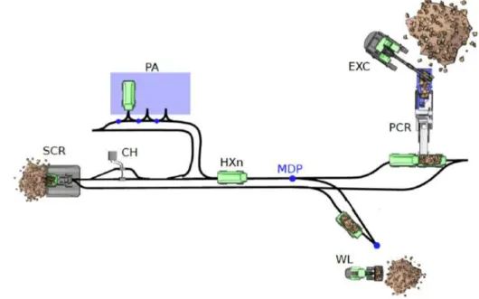
Figure 4, a typical application scenario of a fleet of autonomous TA15 (HX). The quarry sites are being worked as following; Blasting rocks to receive the material, pre-crushing to limit big rocks’ error rates from the first blasting, and pile building by wheel loader. This later gets loaded on to the wheel loader, transporting it to the secondary crusher, getting pre-crushed again to fulfill the rocks’ requirements settled by the customer. [30]
Figure 4: Quarry Site Automation - Electric Site Example, giving the information about how an autonomous site and machinery work in fleets, and charging abilities to sustain an autonomous site always running with assignments and operations.
In Figure 4, borrowed from [5], five HX-vehicles, defined as HXn (TA15), one Wheel loader (WL), and one excavator (EXC). On the left, SCR is placed (secondary crusher), and on the right, PCR (pre-crusher). On top, there is a Parking (PA) spot for HX-vehicles and charging (CH). How does this work then? The loading onto the HX-vehicles is being done by humans, driving the different vehicles, WL and EXC. The HXn drives around, transporting the material from A to B, charging on their way one at a time, depending on the need. The site operator decides how many HX is on the site, where the rest stands on the PA. PCR is loading the material into the HX itself, while the EXC loads into the PCR. On the WL-side, the WL has to load the material onto the HX itself.
Each mine may look different, where the automation system and the safety activities need to be adapted based on the needs. Autonomous sites need to operate without any human interacting on the site, so when doing morning startup, the TA15 gets driven autonomously into the sites, where they start the autonomous operations when the site is clear of objects. To know if the site is safe to start, the site operator needs to know whether the site is clear of objects or not. The site operator also can go around on-site to see if it is clear or not, though this is not sufficient.
Normal on-site operations mean that the autonomous vehicles are assigned missions executed without interruption by either humans, such as getting loaded with a rock by a human-driven wheel loader and transporting this to another position. During an unexpected event, such as an unauthorized human on site, the site operator can press a shutdown button and start a shutdown operation. This is starting an event of a shutdown and immediately stops the site, where all TA15 immobilizes, leaving a safe state and reducing the probability of a hazardous or catastrophic event.
3.3.
Camera Surveillance
Static cameras positioned in suitable locations shall enable the monitoring fleet’s activities from the op-erator’s control room. The video feed from each camera is put on a separate screen in the control room, requiring the operator to watch the screens for possible critical situations continually. Although the oper-ator supervises the fleet and events on-site, the general problem is to keep track of all moving machines and situations at once, as shown in an example in Figure 5.
Figure 5: Example of a CCTV operator, where the operator sits and watches all the CCTV screens at once to sustain the safety on site, using two different methods: overview map of the autonomous vehicle and camera surveillance on site.
The operator is required to identify a critical situation when watching the screens and, if necessary, to stop the fleet of autonomous vehicles by pressing an emergency button.
The site operator is required to react in time to ensure that the safe state, i.e., stops the autonomous vehicles, within a safe period of time. Figure 1, the fault reaction time of a safety-critical embedded system is shown as described in ISO 26262 [13]. Once the fault is detected, the system shall react in a specific time interval, i.e., the fault reaction time interval, to set the system into a safe state. The same mindset is applied here, where the site operator shall react at a specific time to set the system into a safe state.
3.4.
Identifying hazards
To identify critical situations, hazard analysis is conducted. Each situation and function is analyzed to find hazardous events. Typically, a table is used to collect and document all hazards like shown in Table 1
ID Event Humans at Risk Effect
H1 Start of Autonomous Operations and humans at site Unauthorized Human Fatal Injury H2 Normal operation and humans at site Unauthorized Human Fatal Injury Table 1: List of possible critical risks at the site, pre-defined at Volvo CE. The list includes finding humans on start-up and finding people while operating on site. The list is not complete and can be updated due to multiple risks. These risks will be simulated and discussed.
Table 1 exemplifies and simplifies how possible critical events can be identified. Hazard analysis
methods such as Failure Mode and Effect Analysis (FMEA) [32] or the Preliminary Hazard Analysis
4.
Related Work
In this section, we go through the related work of the thesis. Related work is based on similar work where methods are alike with those used in the thesis, and from that, proofs of the correct concept of the method. Research findings from other research groups doing similar works with other assumptions, where the focus of finding related works, prove that the methods of choice are competent to solve the research question and create a verifiable system. In the related work, we mention those other research and point out why it is not working in our context or point out their limitations. NN, object detection methods are in full development, where the question stands, what type of object has to be found and how high does the accuracy need to be to verify the system? How have other projects solved similar problems?
4.1.
Object detection
Similar work, stated below, does not use the image detection system to define and provide operators with a dangerous situation and prevent critical situations. Works, such as Siyi et al. only looking for new ways of tracking objects, [10], never intended to apply the system into safety-critical-system, just giving new object tracking where other research has to implement to prove the use-of-concept. Other related object detection work and future updates can be real-time object detection, tested and optimized within different state-of-the-art surveys and implementations. Jaiswal et al. are proving the use of object detection in UAV real-time object detection, using Graphical Process Unit (GPU) power to gain speed and sustain accuracy [34]. In Jaiswal’s paper, they try different algorithm methods such as feature detection, feature matching, image transformation, frame difference, morphological processing, and connected component labeling to support high accuracy of finding objects and detect their movement. The limitation of these two works is the lack of data usage after their run, where they provide information about the speed and accuracy of the system, not any implementation of real-life uses.
The different object detection system, such as R-CNN and Fast R-CNN, was used in the report from Siyi et al., and Jaiswal et al. Those object detection methods have been proven fast and accurate, but some object detection methods were faster. YOLO is a state-of-the-art, real-time object detection system
[21]. Where different version of implementation exist, such as YOLOv3, YOLOv3, YOLOv4,
Tiny-YOLOv4, YOLOv5 and YOLO-PP (PaddlePaddle, Parallel Distributed Deep Learning) [35, 36]. The
decided NN will be based on how easy it is to implement and how sustainable it is to prove the concept. Most of the researched image detection areas focused on UAV, YOLO-weight was general representations of fast objects detection method, with high accuracy. YOLO is proven extremely fast, more than 1000x faster than R-CNN, and 100x faster than Fast R-CNN, stated by its creators Redmon et al., giving proofs of its result [21]. Zhu et al. [6] point out that YOLOv3 combined with LZZECO, another way to find objects, got the highest score in their enormous dataset of VisDrone. VisDrone was created as the biggest dataset of UAVs, trained with the most used neural network of object detection by Zhu et al. They compared different object detection NN, proving multiple algorithms combined to create the dataset’s best result. YOLO-run itself was average accurate comparing to other algorithms when comparing results of the algorithms on the VisDrone-DET dataset [6].
Supeshala, [36], compares the difference between all the versions of YOLO because new backbones layers have been updated, and stacks have been improved. More efficient YOLO-version, such as
PP-YOLO are now used, aside from PP-YOLOv4 and v5. A lot has happened since Redmon, [21], developed
YOLO. From YOLOv3, the last update with Redmon as the developer to the newer versions; YOLOV4, V5, and -PP. Multiple developers have developed the later YOLO-version since Redmon left the YOLO project because the area of usage YOLO has been taken, where he was not expecting the outcome [36].
The focused research about design methods, where all different works supported improved object detection accuracy, was used to detect object detection and other object detection frameworks. Zhongmin et al. state that the proposed combined algorithm, including YOLO and Meanshift, another method of motion detection, raise accuracy and improves tracking precision [25]. Their proposed algorithm “suits the rapid movement, which has strong robustness and tracking efficiency”, where that states that the support of multiple object detection methods raises accuracy and precision. YOLO never resulted in the best accuracy. The work of Zhu et al. had always result of YOLO being fast and accurate since its speed, but never the best [6]. Same result transpired for Siyi et al., [10], and Jaiswal et al. [34].
Multiple ways of using object detection in multiple areas are some main differences between all the works. Ryan et al. explain in their research [37] how they are applying an UAV for UAV-assisted search and rescue where the applicability from a UAV can be both fast, easy to control, and supportable. They also use UAV alongside with a helicopter “UAVs can assist in U.S. Coast Guard maritime search and rescue missions by flying in formation with a manned helicopter while using IR cameras to search the water for targets.” This prove the statements of using a UAV in the multipurpose area and implementing applications. Nur et al. [4] have later proven the use of UAV in search and rescue applied with Determining
Position of Target Subjects combining with different ways to find an object (see Figure 2. in MSAR search patterns, ref.[4] ).
YOLO was easy to find with pretrained datasets, and since its back-compatibility from YOLOv4 to YOLOv2, old YOLO-versions could be tested. V5 and -PP used other types of backbone that were not
plug-and-play compatible with YOLOv2 and YOLOv4 [36].
4.2.
Object of Interest
Wu et al. [38] are using YOLO comparing to Fast R-CNN to identify objects such as cars, buses, trucks, and pedestrians. Gathering UAV pictures, such as bird-eye view and angled view videos, has been a big interfering of using the right algorithm to the right network. The way the trained networks are learned has a prominent data placement of the different results from this thesis’s output.
Vasavi et al. [39] highlights that counting vehicles like cars, truck and vans is useful for intelligent transportation. They are using the YOLO architecture combined with Faster R-CNN to count the number of vehicles with different spatial locations. The authors are using two pretrained datasets; Cars Overhead with Context (COWC) and Vehicle Detection in Aerial Imagery (VEDAI). The result gave them the proposed system with raised accuracy by 9 percent to detect smaller objects than existing works. COWC is a dataset trained to identify cars in bird-eye-views when VEDAI is a trained dataset for detecting boats, camping cars, cars, pickup, plane, tractor, truck, van, and others. [40,41]
Rabe et al. use their approach of 6D vision, where they estimate the location and motion of pixels simultaneously, which enables the detection of moving objects on a pixel level. This method, combined with a Kalman filter [42], results from 2000 image points in 40-80ms. With the analyzed vectors, the result proves where the object is heading and solve the critical situation. The result was done with an old 3.2 GHz Pentium4 Central Process Unit (CPU), wherein this thesis we mostly used a core I7 5400U 2.1GHz, proving the lack of computer power and GPU may not limit the result. The analytical methods of the critical solution from Rabe et al. can be compared to motion detection in this thesis’s implementation system. The motion detection applicant is an excellent way to find moving objects without knowing the object’s type, but they lack the implementation and usability of their motion detection. The developed motion detection, used in the thesis, has a base of just using OpenCV library [43], making the system fast and supporting threshold changes for filtering out unnecessary information.[44]
4.3.
Neural network frameworks
Redmon is mention that Darknet is an open source neural network framework developed in C and CUDA. The purpose of developing a CUDA-system is because the use of CUDA-cores from GPU’s such as Nvidia makes object detection run faster. Darknet is stated as fast, easy to install, and supports both CPU and GPU computation. Darknet gives the support of using YOLO and also gives the opportunity of an open source neural network framework. [45]
The limitation with Darknet is the backbone of the new YOLO-version, where the new YOLO-version has been updated from Darknet to other backbones [36]. Darknet is nowadays not used within the new YOLO-versions. Darknet was used as a backbone phase, just as ResNet, DenseNet, and VGG. These backbones produce different levels, and the networks use different assessments of layers. Long et al. wrote in their report about the new YOLO-PP, using new backbone. The new blackbone is ResNet50, creating YOLO-PP non-back-compatible with the darknet [46].
4.4.
OpenCV
OpenCV is a tool for the YOLO and other image-processing libraries used in the thesis. Multiple works use the OpenCV library [43], for example, Brdjanin et al. wrote in their paper, using OpenCV as a single Object Trackers. OTB-100 dataset using OPE and SRE combined with Precision and Success Plot succeed to find single object trackers [47]. With OpenCV support, Brdjanin et al. created image processing and libraries for their video and picture data calculations [47].
OpenCV is an Open Source Computer Vision Library with more than 2500 optimized algorithms and state-of-the-art computer vision with machine learning algorithms. It delivers easy access to all video extruded and algorithm support for object detection this thesis [43].
5.
Method
The objective of this thesis is to investigate how to implement additional monitoring features to improve overall safety. One entry point is to investigate how a UAV can be applied to support additional monitoring features, and from there supporting the site operator about critical situations that are about to happen. The site operator will use this system as extra support for notifying critical situations and making decisions. Problem formulating leaving two research question, 5.1.2.
5.1.
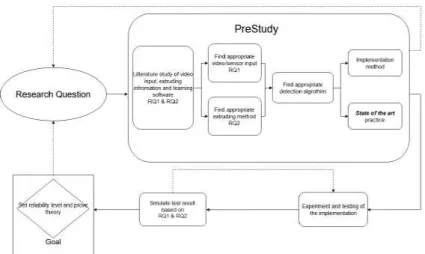
Proposed Structure
The research process shall include proof and solutions to the problem formulation. A literature study shows the appropriate ways to identify objects for this thesis, where the prestudy will determine the best way to go. Experiments and tests will be applied to extruded information from the codes and implementation method, providing solutions for the research questions.
Figure 6: Flow of method from Research question and problem to functional implementation. The simulations will prove the states of the system and reliability. Focused on the implementational, identifying if it can be applied to another system in the future will prove its value and support for the stakeholder. Feedback proves if the reliability needs more testing and more development or is safe to use in any case and implemented in other systems.
After simulation and implementation, the reliability level will be given, and the theory will be proven for both RQ1 and RQ2. Real-time inputs will be tested to prove the variability and multiple inputs to the system, providing a legit result. The already settled system from Volvo CE, for their autonomous site, will be in mind providing the operator correct and informative information without interfering with other vehicles disturbing the autonomous site.
5.1.1 Research Problem
Giving the site operator the highest command, where the system shall only support higher safety and not take over the safety on site entirely, the site operator’s information needs to be informative, usable, and never misleading. The information shall give the operator information if a critical situation is about to happen and raise the safety on site. The system shall detect humans and vehicles on-site in multiples ways, including object detection, edge-detection, and motion detection within the vast area of usage.
From our study of the industrial case, we can identify the following open issues we aim to study in this thesis.
1. It is challenging to keep track of all vehicles through the camera surveillance system and watching all screens with the camera feeds.
2. The site operator is required to react in time to set the system into a safe state if required. This thesis aims to support the site operator to identify critical scenarios using an independently operated UAV.
5.1.2 Research Questions
• Research Question 1 (RQ1): How can a UAV be used to detect humans and vehicles at such a site? • Research Question 2 (RQ2): How to support the site operator in monitoring safety critical situations
in an open surface mine with autonomous vehicles? 5.1.3 Research Methods
Problem statement Problem statement is not the same as the research question. Problem statements shape research questions, where statements are found through the autonomous site of Volvo CE. To solve these issues, mention before; It is challenging to keep track of all vehicles through the camera surveillance system and watching all screens with the camera feeds. and The site operator is required to react in time to set the system into a safe state if required. reasonable solutions need to be assembled to solve the issues and problems. Literature Study Studying the fields of practice, literature, and identifying of already available methods
of solving the object detection problem. Many studies use methods to find objects and combine different NN to gain accuracy and speed, but it comes to choose those works where the field is closest to the settled field of practice. Understanding object detection, we studied literature to find solutions to the open issue. We used the following databases for our search of relevant literature: IEEE, Springer Link, PapersWithCode, arXiv, and books. Even other sources were considered where additional information was provided. Design Research We applied a design research method for developing the object detection solution
pre-sented as a result of our work. The design research method requires is a type of research method, where a product is iterative developed with continuous validation and feedback loops. The process and tools developed throughout this research where continuously im-proved and refined based on real application data from the industrial site. Specifically, we applied Python as programming language to enable a fast prototyping and refinement, since the purpose of this research was a proof of concept. Based on our literature study, many researchers utilize Python as well. Other works use other programming languages like C, which requires a more stringent development process and more development ef-forts, which was out of scope for this research.
Validation As we pointed out before, the results have been continuously validated in real-life applica-tions at the Volvo CE test track. In comparison to applying simulaapplica-tions, the application of the UAV in real environments enabled us to validate and refine our results contin-uously. An important question on how the system interferes in real-life environments was part of the validation activities. In the shortness of time, we were not able to test different weather conditions, which might have an impact on the results.
5.2.
Evaluation
With the information gathered from the prestudy and other similar implementations in previous projects, filtering and optimization will be applied, not focusing on speed but accuracy. Proofs will be provided from using a UAV as an extra safety layer on an autonomous site while object detection, edge detection, and motion detection combined will be a fast and stable method for image detection, determine the research-questions and problems.
Additional monitoring features of a site appropriate data extraction need to be identified and evaluated with collected information from the UAV. Reliability is an essential characteristic that such a network shall provide to enable the application in safety-critical use cases. To provide a structured evaluation of the potential network, a need to identify objects and identify critical situations from the data, provided from the UAV and the code. Comparing the different outputs from the code, such as gridmap and object detection, real-life viewpoint on Volvo’s autonomous site will be necessary. Since no focus on introducing the implementation into Volvo’s autonomous system, the Evaluation needs to be done by hand and proving that the system is accurate enough to use as an extra safety layer for site operators.
5.3.
Limitations
The limitations are based on the research questions, where the main focus will be to uncover the most reliable algorithm for this specific task and implement it. Also, leaving behind a thesis available for future updates and implementation.
All the different object detection methods and applications cannot be described since there are so many and no need to implement comparison. The choice of object detection application will be due to its support for easy implementation and development. For this thesis, speed combined with accuracy and easy-to-implement is the main area to looking into when choosing an algorithm. YOLO has been shown as a fast algorithm, with high accuracy and easy-to-install. Therefore the choice of algorithm to implement was YOLO.
RQ2 will be based on an pretrained network to save time and create a workable and provable im-plementation. RQ2 will be based on the data extruded by the settled UAV (DJI Mavic Air). If there are other essential data needed to sustain accuracy and higher dependability, it will be researched and discussed but not implemented. The focus will be to prove the proof of concept and not create a fully working implementation.
This thesis’s primary goal is to investigate how a UAV can support the Site Operator by monitoring the site. This work uses existing tools like the OpenCV library, [43], to identify humans and machines in motion at any site of choice. The target is to identify critical stations and support the site operator in decision making. The task is to evaluate how a UAV could support the Site Operator to ensure higher safety at the site. This focus will lead to other on-site-notifications such as humans on-site, other vehicles on-site, or unplanned interaction, such as ”unintended” human interaction on site.
6.
Implementation
This section describes our implementation’s technical details, where we have collected information, con-figure essential software, and applied a neural network to fulfill the thesis’s requirements. To thoroughly test the implementation, creating a simulation was necessary, such as OpenCV image viewer where a video configured with YOLO can prove that the problem formulation is solved, verified by the operator and user. By this, verification is done, and where to see if necessary changes must be implemented in the system, or critical states findings need to be adjusted.
6.1.
Process of system, basic overview
The dedicated UAV to the project is a DJI Mavic Air, even though it is closed source code on the DJI’s product. There was a consideration between DJI Mavic Air and an open source drone called Open Drone, a project from Malardalens University. We compared pros and cons, and a decision to use the DJI drone was made [48,49]. The decision to use a UAV from DJI instead led to a faster workflow for the data collection where proof of concept was in focus, considered is was closed source. The Open Drone project was an open source project developed at Malardalens University, using flight control computer from open source developer pixhawk [50]. Open Drone would have been an excellent UAV to use in this thesis, except it did not have any camera included, and no support was implemented for streaming or stability of cameras, and this would take unnecessary time to implement for this thesis [48].
The implementation can be used in defined task and assignment, where the YOLO-weight file is trained on those specific object that needs to be detected. For example, in this thesis, the dataset used is an pretrained network, with everyday objects such as vehicles, groceries, humans, and more, where the focus will not be to create or train datasets. The usage of an pretrained dataset will limit the result to the pretrained and selected dataset. All tested datasets are standard without any editing except filtering out unnecessary data, such as detecting groceries. On-site, trucks need to be detected, wheel-loaders, humans, TA15, and maybe animals. Proof of using a fast and accurate algorithm will be necessary because computer power usage will rise when more objects get included.
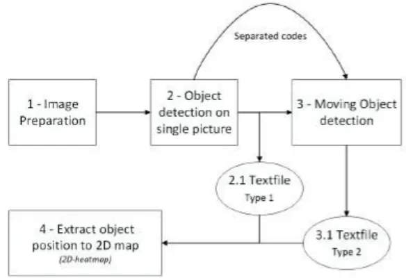
Figure 7: Basic structure of the implementation.
In Figure 7 shows the basic overview of the system, and the different steps define the different chases. Step 1 Image preparation is being done, where extruding a picture from a frame of the video. Step 2 The picture is interested in the object detection, where the object detection is using
YOLO and edge-detection to find an object on the picture.
Step 3 The alternative of using motion detection, attached in a different code, is shown. Motion detection is an extra redundancy interfering with the support of gaining accuracy for object detection from step 2. From both step 2 and step 3, a textfile is created where the files are stored as a buffer for the next step. There is one textfile for each object detection and motion detection.
Detail information off all the steps is being shown in Figure 10, 13, 14 and 15.
To prove the implementation’s easy to install and use, basic process-visibility needs to be hand over where the user, or future developer, could see how the implementation behaves and how to install the procedure. Every box in Figure 7 will be discussed further below and go into every subject’s depth, showing and defining every implementation process’s usage. Textfile type 1 is the output from the object detection version, where Textfile type 2 is from the moving detection. Type 2 needs data from Type 1 to solve distance calculation, such as camera angle and height of UAV. All steps use library OpenCV to handle video inputs, frames extrusion, and picture creation. YOLO is also applicable to the OpenCV library, making it easier to handle inputs such as videos [43].
6.2.
Calculation basis for gridmap
By going over objects, such as people and vehicles, a definition of the distance between the two objects was made. The coordinates from the UAV was used, and the object position was made. This limits the UAV’s use of bird-eye-view and finds the object straight under in the center of the camera, extruding the coordinates. For this to work on multiple vehicles, the UAV then have to fly to the next object to verify its position. This takes extra time comparing to the Pythagorean theorem-method, 9. More errors can occur over the other method since more objects need to be detected, and higher accuracy can not be granted. However, this method is more distance-accurate since the drone could use its coordinates over the vehicle and other vehicle coordinates in future updates. This also raises the accuracy of positioning the vehicles when combing all methods, including the Pythagorean theorem-method and the future support of triangulating with the site vehicles, if that future update would be fact.
Coordinates from the UAV are being extruded from flight-data-recorder in DJI GO 4 application (IOS usage) as a CSV-file, reading coordinates every 10HZ. Different events such as “staying still for 5s” sets a timestamp in the CSV-file, and from there, data and coordinates can be extruded.
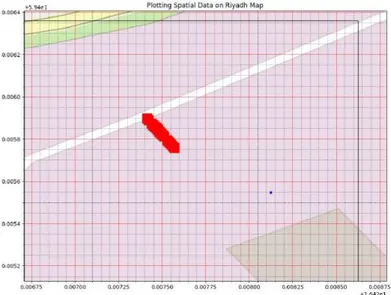
Figure 8: Gridmap where blue square is the UAV and the reds squares are the detected objects. Straight upward is the North, while left is west, right east and down south. The compass angle from the UAV will be used to referee where the object are referring to the UAV. This is being static in the gridmap code, appendix C
Using image detection to find objects, where accuracy can differ depending on different weight- files, the founded objects’ usage gets analyzed with a coordinate system on the image viewer from the script. Therefore, the data will be extruded where the vehicles and humans are placed on the picture, and from there, calculate the distance between the objects. By defining the length of the pixel in the camera distance between object, offset position has been found, and by using height, angle of the camera, and GPS-coordinates data, new information is being calculated from the available information.
Figure 9: Usage of pixel and height, giving information about how to use the camera angle, UAV height, UAV coordinates and the detected object. The only missing variables then is the distance to object, being calculable.
Using the Pythagorean theorem, pixels, and height, we can define an object’s length and calculate the distance between the object and UAV. This gives objects distance in the object detection output and could define if a situation could be dangerous or not. It is easier to find objects during an angled camera due to its more significant RGB inputs from the object, and since most of the training in the YOLO-datasets is trained on objects standing aside. The accuracy is better with an angled camera. Therefore that is the way to record videos for tests. From there, multiple objects can be found, such as humans and vehicles, print them on the heat map, and from there, see to define if it is a critical situation or not.
6.3.
Preparation of image
Using the film from the drone and OpenCV library, a simple one-frame from the video was extruded and create a calculable picture to run in YOLO and Edge detection.
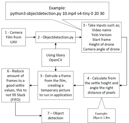
Extruding the data from the drone, such as camera angle and CSV-file from the DJI go application [51], where that information is needed later to do the calculation. However, the extrusion of video, camera angle, and CSV-file is all needed for the implementation.
Figure 10: Overview of objectdetection.py-code, appendix A with preparation-of-image focus. In figure 10,
Step 1 Manual user implementation, such as defying what videos are being extruded of its frames, creating a picture to use in a run. The video is being defined in the command; see example in Figure 10.
Step 2 User define what frame to start on, what version of object detection dataset such as YOLOv2-tiny to YOLOv4 [52]. The user gives the system the input of the UAV height, seeing on the DJI-go application, and what angle the camera is in, also viewed in the DJI-go application. All this shall include in the command when running the application. Step 3 Just showing the data needed to run the application, and when the command has been run, and all data is included, the application starts. If not all data is defined, it warns that information is missing and do not start.
Step 4 Estimates distance using the height of the drone, and a point in the middle of the picture, estimating how many pixels is a specified distance, such as 28px 1.8m.
Step 5 The extruded picture is being applied in the loop, where every new run, a new picture is replacing the old in the loop process. Pictures are being extruded from the frame from the user-decided video.
Step 6 Extrudes a picture from a specified frame, once every ten frames. Step 6 can be edited by the operator or user, depending on the computer’s compute-power. Having a more
powerful computer, or GPU with CUDA-support [53], the system can be run in higher
Frames per second (FPS) and use a higher amount of frames raising the accuracy and the probability of finding objects.
6.4.
Data inputs
This section gives what inputs need to be achieved by the user, and what data the system requires to operate, also, how the mathematical aspect of the calculations has been created.
6.4.1 Camera angle
Figure 11: A visual figure about how the camera angle works for the UAV. bird-eye view is zero degree angle, while straightforward view is going to 90 degrees angle.
The camera’s defined angle, inserted by the user like the example in 10, for the object detection to find where the object is on the map, see Figure 15 The needed information is applied to be calculated through a equation of distance and coordinates, equation 1 & equation 2 The information gets calibrated in the object detection file and stored in a new text file created by the object detection. The previous data that was introduced, angle and height can be used to determent where the object is from the perspective of the UAV position .
6.4.2 Equations
Equation in map.py, appendix C, gridmap equation for calculation distance to object d = distanceT oObject
R = radiusOf Earth = 6378.1km
(AngleOf U avT oN orth + angleOf ObjectF romOf f set) ∗ π/180 = Bearing
arcsin(sin(U AV Lat) ∗ cos(d/r) + cos(U AV Lat) ∗ sin(d/r) ∗ cos(bearing) = Latitude
U AV Long + arctan(
sin(bearing) ∗ sin(d/R) ∗ cos(U AV Lat), cos(d/R) − sin(U AV Lat) ∗ sin(Latitude)) = Longitude
(1)
Equation 1 is inspired by Veness function to calculate longitude and latitude coordinates using multiple inputs, [54]. The function variables are changed to fit the system, and the variables are defined in appendix C. The angles that are multiplied by pi divided by 180 is to make degree into radians.
The equation is applied in the map-plot script, of map.py, appendix C, Longitud later converted to degrees to create decimal-degree-coordinates. Distance to object is calculated as in equation 2. Camer-aAngle is defined as angle zero degrees is right under the UAV was ninety degrees goes to a high distance measurement that is excluded by the system since the value is not accurate to use. Recommended usage is
Equation in objectdetection.py, appendix A, variation depending on the angle of the camera
P reEstimatedDistane ∗ sin(CameraAngle ∗ π/180) = EstimatedDistance (2)
Equation 2 is made to assure the accuracy of the distance to the object from the position of the UAV, only using simple inputs. This is done since the pre-estimated distance may vary, deepening the camera’s position and angle. The pre-estimated-distance is only to make the system pre-define a distance, where later is using the object-detection to precise the distance. This is being made since the pre-estimation is using pixels of the frame, for example, 1920x1080, were then using the angle and the height of the UAV, the center in the frame should be in at a specific distance from the UAV, excluding the field of vision for the camera lens. Object detection detects an object, where the object is a human. Humans are around heights of 1.8m, giving or taking 20cm, leaving a way to increase accuracy. This is a way to make more accurate information and remove error-rates. That calibration is using a recursive loop.
6.4.3 Angle to object
The angle to object is needed to define the distance to the object and the angle it is estimated to be at from the perspective of the UAV. This, combined with the bearing, is needed to make position on the 2D-map.
Figure 12: 2D-view how to measurement the angle to the object, UAV perspective. A distance is being measured, were finding where the object is and what angle the object is related to the position of the UAV, detailed pictured in Figure 12. The white circle is the virtual object, defined in the code, where giving the object a distance if it was in the right in front of the UAV. Later, by using the angle to object, creating a 2D view of where the object refers to the UAV. When the distance from UAV has been estimated, information is used in 2, and stored in a textfile. The last step is being used in 1, where the last calculation generates coordinates from the stored information.
6.5.
Object detection
The python-script of object detection, using user-decided YOLO dataset [52], working in the way of applying the drone’s values such as; video-name, YOLO-weight file version, start frame, the height of the UAV, and camera angle to settle where the object is comparing to the drone. The run is not just using YOLO object detection. The object detection is combined with edge detection for the bird-eye view object detection, using the OpenCV image library [43]. Using YOLO on the picture extruded from the decided video, the image detection uses pretrained datasets and can determent different classes to sustain the system with information. From the first YOLO-run, values have been gained, such as position on the object on the frame and from there, calculate where the object is. Length1 and Length2 are being estimated, 12, and from that use, AngleToObject defines where the object is, more precisely.
Figure 13: Overview of object detection with YOLO and Edge detection, and how the object detection frameworks proceed with the image extruded from videos or streams.
In Figure 13, we describe the object detection part of the python code Objectdetection.py, appendix A where two blocks divide the neural network and edge detection. Firstly, user-decided video is being introduced to prepare the picture to be used in the loop, see Figure 10. A YOLO-weight file is also being introduced by the user, depending on what type of pretrained YOLO-weight file that wants to be used in the system [52].
Step 1 In the YOLO part of the code, transformation of an image to a blob is being done [55]. Step 2 Identify an object, the pictures are being divided into multiple boxes, where identification of an object is being made with the weight file’s support. If the weight file is big and trained in a higher amount of datasets, the system will take a longer time to identify an object but have better accuracy on the identified object, while smaller weight files such as YOLO4-tiny, is faster but less accurate. The boxes mentioned before dividing the picture into another with multiple objects detected.
Step 3 The system summarizes the boxes into one where only printing the object with the highest confidence. For example, it is unnecessary to print an identified broccoli with an accuracy of 0.05, 5 percent, while the system has identified a person with 0.95 accuracies, 95 percent? No, of course not.
Step 4 Safety circle is printed around the squares to limit the area around an object and identify if a person or object comes too close, creating a critical situation.
6.6.
Motion detection
Other implementation will be necessary to gain accuracy and support algorithms, such as moving detection
when the UAV is in a fixed position to support YOLO algorithm. This method will not need much
computing power to prove if a vehicle or person is moving or not [56]. The result will show if an object is moving, not what type of object. The decided object detection algorithm will show what object is moving, while the moving detection will store in a buffer from the algorithm, YOLO object detection in the leading network of this thesis, and YOLO is the only object detection in this thesis that can provide information on what type of object is moving.
Motion detection is an another in-house developed code, based on Rosebrock “Basic motion detection and tracking with Python and OpenCV” [56], aside from the previous object detection and edge-detection script. The application is as an extra layer of safety to sustain the entire object detection system, redundant. If following an object, such as a TA15, motion detection can see and stating that a “moving object within the same area of previous coordinates from YOLO is found”. Therefore, the object has to be the same for some detection in the frames to determine that the object has to be that specific object detected object, specified from the YOLO and edge detection script. However, an increase of the system’s accuracy is applied with motion detection, and non-defined objects can be found even if the datasets are not trained to other entities. If YOLO object detection have not found any object within the dataset, the motion detection will show a moving object where the operator can decide. If the UAV is moving too much, motion detection will find the frame moving and leave warnings on everything.
Motion detection creates its text-file since motion detection has no calibration-tools of its own to estimate distance accurately. Motion detection only supports finding a moving object and where they seem to be, compared to the UAV and not more. Data is being printed into the gridmap as a simple 2D-viewpoint.
Figure 14: Basic overview of motion detection. In Figure 14 we have multiple steps such as previous object detection, Figure 13.


![Table 1 exemplifies and simplifies how possible critical events can be identified. Hazard analysis methods such as Failure Mode and Effect Analysis (FMEA) [32] or the Preliminary Hazard Analysis (PHA) [33] can be applied to identify hazards in a structured](https://thumb-eu.123doks.com/thumbv2/5dokorg/4739728.125671/15.892.129.789.834.897/exemplifies-simplifies-identified-analysis-analysis-preliminary-analysis-structured.webp)