Potential impacts of hydrologic changes on nutrient loads in the South
Platte River Basin
Ryan W. Webb
Department of Civil and Environmental Engineering, Colorado State University Misti D. Sharp
Department of Agriculture and Resource Economics, Colorado State University Benjamin C. Von Thaden
Department of Ecosystem Science and Sustainability, Colorado State University
Abstract. Understanding the potential impacts of hydrologic changes on nutrient loading within a system is paramount to developing adaptation strategies. This case study investigates the impact of varying hydrologic conditions on water quality within the South Platte River Basin in northeastern Colorado. 80% of Colorado’s population lives within the South Platte River Basin in addition to providing water for the most productive agricultural landscape in the state. Nutrient concentrations within the river basin depend on seasonality, land type, land use management practices, and point source inputs from wastewater treatment plants. The river basin contains mountainous, urban, and agricultural settings which, in combination with the semi-arid climate of the South Platte River Ba-sin, produces the potential for droughts, fires, and floods to cause significant changes on the hy-drology of the river. This study analyzed nutrient data from mountain, urban, and agricultural set-tings under various stream flow conditions which were present during the period of record. The hypotheses of this study were that water quality is related to stream flow during the time of sam-pling, the stream flow preceding the sampling date, as well as a relation with the dominant land cover classification of the area immediately upstream of the sampling location. The impact of treme events, such as drought and fire, on water quality were also investigated. This talk will ex-plore results of these investigations as well as some of the limiting factors such as data availability for long term studies in Colorado.
1. Introduction
Understanding the potential impacts of hydrologic changes on a regional and global basis is paramount to developing adaptation strategies. A common factor driving potential hydrologic changes in literature is climate change (Barnett et al., 2005, Rasmussen et al., 2014). Many models of climate change have been used to predict the impact of tempera-ture and precipitation shifts on the hydrology of a basin (Kang and Ramirez, 2007, Ras-mussen et al., 2014). Less understood is the potential impact of climate change on future water quality.
Climate change research generally takes on one of two perspectives: a global perspec-tive or a regional perspecperspec-tive. Global studies typically project temperature or climate vari-ability into the future to determine the potential impacts of these climate effects on differ-ent sectors (Adam et al., 1990, Barnett et al., 2005). Such studies show that climate change will have a global impact but invariably, there will be differing regional effects
Potential impacts of hydrologic changes on nutrient loads in the South Platte River Basin
runoff and increased variability in snow covered days (Baron et al., 1998, Harpold et al., 2012, Lukas et al., 2014, Murdoch et al., 2000, Rasmussen et al., 2014). Even with a strong emphasis on global and regional climate change impacts on water resources, few papers have studied impacts on water quality.
The SPRB is an ideal location for a study investigating the potential impacts of hydro-logic changes on water quality as a result of climate change predictions. The basin con-tains a diverse array of land cover and water usage (Fig. 1) along with several notable ex-treme events in the last decade spanning the gambit of possibilities including drought, flood, and fires. Both water quality and water quantity concerns dominate discussions within the basin with the projected impacts of climate change. In addition to projected climate variability, the population in the region is expected to increase approximately 2.5 million by the year 2050 furthering the urban footprint within the basin (CWCB, 2011) (Fig. 1). In addition, the SPRB supplies the most productive agricultural landscape in the state of Colorado (CWCB, 2011).
Nutrient concentrations in the SPRB depend on seasonality, dominant land use of the contributing area, management practices, and point source inputs such as waste water treatment plants (WWTPs) (Pocernich & Litke, 1997). As such, ammonia, nitrite, and ni-trate are commonly monitored constituents in the South Platte River; these constituents are known to have hazardous effects for aquatic life, animals, and humans when ingested (Pocernich & Litke, 1997). Recently, new regulations have been adopted in order to limit the nutrient concentrations from these point sources (Regulation 85, 2012). Sprague (2005) investigated the impact of drought on water quality and found that during a drought in 2002, increased nutrient concentrations at some agricultural sites were attributed to de-creased dilution of irrigation return flows. It was also noted that dissolved nitrite-plus-nitrate concentrations were significantly different at forested, urban, and agricultural sites attributed to differing water management, stream size, and nutrient sources such as direct fertilizer application on crops (Sprague, 2005).
This study seeks to determine the potential impacts of hydrologic changes, resulting from climate change, on water quality in terms of nutrients within the SPRB in Colorado. The objectives of the study are to: explore the relationship between water quality and land use, determine possible impacts of extreme events on water quality, and project vulnerabil-ity of the SPRB to hydrologic changes projected under climate change estimates. The hy-potheses are that water quality will show a relation with stream flow, land cover/use, and extreme events.
2. Methods
Water quality data from the National Water Quality Assessment Program (NAWQA) (USGS, 2007) was utilized in order to determine water quality trends occurring in the SPRB. Sites for this study were analyzed only if the period of record included a minimum of 30 sample dates. This selection criterion resulted in seven locations analyzed represent-ing comparisons between mountain, urban, and agricultural settrepresent-ings (Fig. 1, Table 1) (Jin et
al., 2013). This 30 data point minimum criterion additionally reduced this study to analyze
Figure 1. Area map of the South Platte River Basin depicting the land cover classification (Jin et al., 2013), location within Colorado, as well as the locations of the sites used for this study.
Table 1. Sample locations and classification used for this study.
Site No. Name Upstream Classification
1 Big Thompson below Moraine Park Mountain
2 Cherry Creek at Denver Urban
3 SPR at Denver Urban
4 SPR at Henderson Agricultural/Urban
5 SPR near Kersey Agricultural/Urban
6 SPR at Cooper’s Bridge near Balza Agricultural
7 South Platte at North Platte Agricultural
In order to determine whether water quality data displays a relation to stream flow, USGS daily stream gage data was additionally utilized. Water quality data were first com-pared to the daily discharge data occurring the same date as the water quality sampling. The second comparison was that of the 30-day cumulative discharge prior to the water sampling date. These analyses were conducted for nutrient concentrations as well as esti-mated nutrient loading based upon the discharge data. Extreme events for this study were limited to fires (MTBS, 2014). Extreme events for this study were limited to fires due to the available period of record which exists within the water quality data as well as the land
Potential impacts of hydrologic changes on nutrient loads in the South Platte River Basin
3. Results
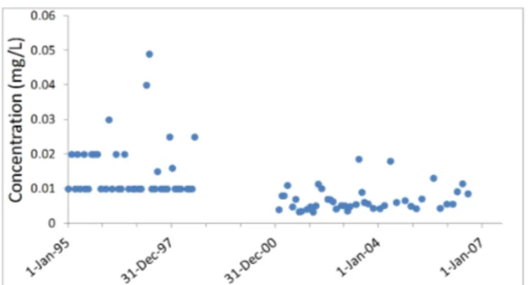
The analysis of the seven sampling sites (1 mountain, 2 urban, and 4 agricultural) clearly display nutrient variability among the different land use settings. The mountain setting displayed the lowest observed nutrient concentrations (Fig. 2). The mountain loca-tion did not have a collocated stream gage for discharge data as well as only having data for phosphorus concentrations. The phosphorus concentrations remained relatively low during the nearly 11 year period of record (January 1995 – August 2006) with a maximum of 0.05 mg/L and average of 0.01 mg/L.
Figure 2. Time series of phosphorus concentrations for the
Big Thompson below Moraine Park sampling location (moun-tain setting).
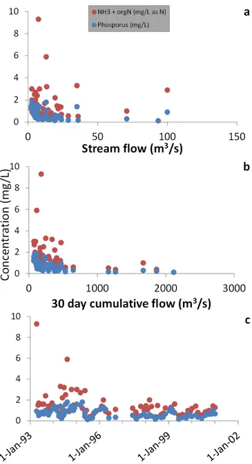
Urban locations (South Platte at Denver and Cherry Creek at Denver) showed higher concentrations of phosphorus with a maximum of 3.0 mg/L. However, the concentrations were consistently below 2.0 mg/L with an average concentration of 0.2 mg/L for Cherry Creek at Denver and 0.7 mg/L for South Platte at Denver (Fig. 3). No stream flow data were available for the Cherry Creek sampling location. However, the South Platte at Den-ver location displays a clear dilution of concentrations with stream flow for both phospho-rus and NH3-plus-orgN, particularly with respect to the 30 day cumulative discharge prior
to the sampling date (Fig. 3). The highest concentration of NH3-plus-orgN at this location
was 9.3 mg/L as N with an average of 4.3 mg/L as N for the period of record (June 1995 – January 2001).
Two locations were considered to rest within an agricultural/urban setting (South Platte near Kersey and South Platte at Henderson). The South Platte at Henderson location ob-served higher concentrations of both phosphorus and NH3-plus-orgN relative to the South Platte near Kersey location. The maximum concentrations observed between the two loca-tions were 3.0 mg/L of phosphorus and 8.8 mg/L as N of NH3-plus-orgN, both being
ob-served at the Henderson location. Average phosphorus concentrations were 0.8 mg/L and 1.6 mg/L for South Platte near Kersey and at Henderson, respectively. Average NH3
-plus-orgN concentrations were 1.7 mg/L and 4.4 mg/L as N for South Platte near Kersey and at Henderson, respectively. Both sample locations also displayed a dilution of nutrient con-centrations with higher stream flow rates (Fig. 4).
Figure 3. Concentrations for the South Platte River at
Denver location (urban setting) with respect to a) stream flow on the sampling date, b) 30-day cumulative discharge prior to sampling data, and c) in time.
Potential impacts of hydrologic changes on nutrient loads in the South Platte River Basin
Figure 4. Concentrations for the South Platte River near Kersey location with respect to a) stream
flow on the sampling date, b) 30-day cumulative discharge prior to sampling data, and c) in time in ad-dition to the South Platter River at Henderson location with respect to d) stream flow on the sampling date, e) 30-day cumulative discharge prior to sampling data, and e) in time. (Urban/Agricultural set-ting).
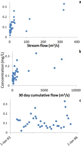
The agricultural locations (SPR at Cooper’s Bridge near Balza and South Platte at North Platte) displayed results for only phosphorus concentrations. No discharge data was available for the SPR at Cooper’s Bridge location. The period of record was relatively short for these locations (April 1993 – February 1996). However, fluctuations of phospho-rus concentrations were still observed relative to streamflow for the South Platte at North Platte location (Fig. 5). The South Platte at North Platte is the only location with discharge data which displays an increase in phosphorus concentrations with relation to stream flow, both discharge the same day of sampling, and 30 day cumulative discharge prior to sam-pling (Fig. 5). Additionally, the year which the highest phosphorus concentrations were observed (1995) is considered to be a year with higher flows following lower flow years (Davitt, 2011). The maximum phosphorus concentration observed at these two locations was 1.2 mg/L at the SPR at Cooper’s Bridge site. The average concentrations for the
loca-Platte, respectively. Though it is difficult to make conclusions with only partial temporal overlap between sites, the agricultural locations have noticeably lower phosphorus concen-trations, suggesting WWTPs have a higher contribution towards these concentrations.
Figure 5. Phosphorus concentrations for the South
Platte River at North Platte location with respect to a) stream flow on the sampling date, b) 30-day cumula-tive discharge prior to sampling data, and c) in time.
The only extreme event which occurred in the SPRB within the nutrient periods of rec-ord available for this study was the Hayman fire. The Hayman fire occurred during the summer of 2002, burning a total area of 138,000 acres (MTBS, 2014). Only one of the sample locations for this study has samples taken at the appropriate times and would have been impacted by this event. This location is the South Platte near Kersey. However, it is unclear if the results of the fire can be seen in the data due to high concentrations occurring prior to the fire as well as the fire occurring upstream from multiple controls. It is certain,
Potential impacts of hydrologic changes on nutrient loads in the South Platte River Basin
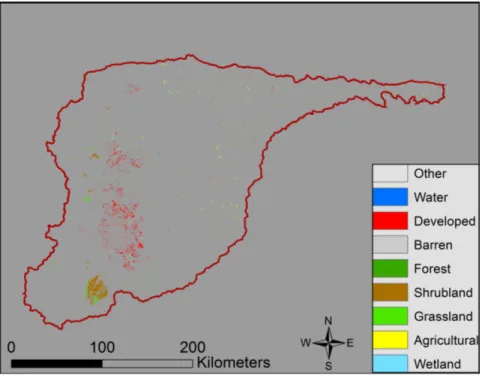
Figure 6. Land cover changes from 2001 to 2011 within the South Platte River
Basin. The symbology displays the new land cover classification is according to the 2011 dataset. No symbology represents no change in land cover over the ten year period. (JIN et al., 2013)
4. Discussion
The analysis of the seven locations within the SPRB clearly displays nutrient variabil-ity between the different settings. The mountain setting displayed the lowest observed nu-trient concentrations and likely had the lowest flow rates, although no discharge data were available. The urban and urban/agricultural settings resulted in higher nutrient concentra-tions, likely from WWTPs. Although nutrients are monitored at nearly all WWTPs in Colorado, ammonia is the only nutrient with an in-stream standard for the SPRB during the period of record of this study. New standards, such as Regulation 85 on point and non-point sources are likely to drive nutrient levels within the SPRB going forward. With fu-ture population increases expected throughout the Colorado Front Range and imminent water scarcities, WWTPs along the urban corridor will be forced to deal with rising nutri-ent concnutri-entrations which can pose a threat to stream health and downstream water users. Regulation 85, limiting nitrogen and phosphorus loadings to the river, was adopted in June 2012 by the Colorado Department of Public Health and Environment Water Quality Con-trol Commission as an instrument to conCon-trol pollution from both point and non-point sources. This regulation extended existing legislation setting lower limits for nutrient pol-lution from WWTPs while at the same time including the previously un-regulated non-point sectors such as urban storm water and agriculture. Much of the nutrient levels in the mountain areas were commonly below the standard of 0.1 mg/L for phosphorus whereas agricultural and urban segments often exceeded these limits by factors ranging from one to three for the agricultural setting and as much as 20 for the urban settings.
relation between phosphorus and stream flow relative to other sites. This is likely due to the relatively low flow years prior to the high flow year which produced the increased con-centrations at the furthest downstream site. Phosphorus can often be attached to sediment loads (Xinzhong et al., 2014) which is known to be a dynamic process, particularly after events such as forest fires (Moody and Martin, 2001). It is likely that the sediment loads and adsorbed phosphorus was being deposited along the streambed during low flow events which did not produce enough energy to move the sediment through the entire basin. Then, during the higher flow year in 1995, enough energy existed within the river to transport the sediment and adsorbed phosphorus through the South Platte at North Platte sampling location and out of the basin. With the higher number of drought years in the fu-ture predicted as a result of climate change (Barnett et al., 2005, Harpold et al., 2012); it is important to understand that with a reprieve from the drought in the form of a higher flow event, the result may be increased nutrient loads such as phosphorus. Further investigation and analysis of more robust datasets are necessary in order to test and further support this predicted increase in nutrient loading.
Data availability proved to be a major limiting factor in this study. There are a number of sampling locations within the SPRB which have produced less than ten publically avail-able data points over the past 25 years. This is insufficient to produce any significant anal-ysis. The seven locations used for this study often had periods of record which did not co-incide with other sampling sites or were not continuous, thus creating a difficult dataset to test for trends and compare between locations during similar hydrologic conditions. With the various climate change scenarios projected and the potential impacts that could occur on the nutrient cycles, predicting the effects on nutrient loadings with insufficient datasets will produce erroneously large margins of error. Proper planning for future nutrient regu-lations would require more robust datasets in order to draw more significant conclusions.
4. Conclusions
The results of this study indicate that extreme events such as fire and droughts can have an impact on the nutrient loading of the SPRB. Years of lower flow rates within the South Platte River may deposit phosphorus at locations within the river bed and hyporheic zone to be stored until a higher flow event produces the energy to transport the nutrient through and out of the basin. WWTPs have a clear impact on nutrient concentrations in the urban and urban/agricultural settings of the sites analyzed in this study. However, the anthropo-genic component of the SPRB cannot be ignored because this part will most certainly set the tone of water quality issues in the coming years. Farmers and WWTPs are currently aware of water quality issues related to nutrients and it will be largely their responsibility to be leaders of best management practices on this issue in the face of climate change. Acknowledgements. This research was facilitated by the GRAD 592 interdisciplinary water re-sources seminar during the fall semester of 2014 at Colorado State University. We would like to thank the professors who took the time in organizing this course and the guest lecturers who took the time to speak with the class throughout the semester.
Potential impacts of hydrologic changes on nutrient loads in the South Platte River Basin
References
Adams, R.M., C. Rosenzweig, R. Peart, J. Ritchie, B. McCarl, J. Glyer, R. Curry, J. Jones, K. Boote and L. Allen, Jr., 1990: Global Climate Change and US Agriculture. Nature 345: 219-224.
Barnett, T.P, J.C. Adam and D.P. Lettenmaier, 2005: Potential Impacts of a Warming Climate on Water Availability in Snow-Dominated Regions. Nature 438: 303-309.
Baron, J.S., M.D. Hartman, T.G.F. Kittel, L.E. Band, D.S. Ojima and R.B. Lammers, 1998: Effects of Land Cover, Water Redistribution, and Temperature on Ecosystem Processes in the South Platte Basin.
Eco-logical Applications 8(4): 1037-1051.
CWCB, 2011: Colorado’s Water Supply Future: Statewide Water Supply Initiative 2010. Colorado Water
Conservation Board, January 201.
Davitt, A., 2011: Climate Variability and Drought in the South Platte River Basin. Master’s thesis, The City College of the City University of New York, New York. May 2011.
Harpold, A., P. Brooks, S. Rajagopal, I. Heidbuchel, A. Jardine and C. Stielstra, 2012: Changes in Snowpack Accumulation and Ablation in the Intermountain West. Water Resources Research. Vol. 48, W11501, pp. 1-11 doi: 10.1029/2012WR011949.
Jin, S., L. Yang, P. Danielson, C. Homer, J. Fry, and G. Xian, 2013: A comprehensive change detection method for updating the National Land Cover Database to circa 2011. Remote Sensing of Environment. 132:159-175.
Kang, B. and J. Ramirez, 2007: Response of Streamflow to Weather Variability under Climate Change in the Colorado Rockies. J. of Hydrologig Engineering. 12:63-72.
Litke, D. W., 1996: Sources and loads of nutrients in the South Platte River, Colorado and Nebraska, 1994-95. U.S. Geological Survey, Department of the Interior.
Lukas, J., J. Barsugli, N. Doesken, I. Rangwala, and K. Wolter, 2014: Climate Change in Colorado: A Syn-thesis to Support Water Resources Management and Adaptation. Second Edition. A report for the Colo-rado Water Conservation Board, August 2014.
Moody, J. and D. Martin, 2009. Initial hydrologic and geomorphic response following a wildfire in the Colo-rado Front Range. Earth Surface Processes and Landforms. 26:1049-1070. Doi:10.1002/ESP.253. MTBS Data Access: Fire Level Geospatial Data. (2014, April – last revised). MTBS Project (USDA Forest
Service/ U.S. Geological Survey). Available online: http://mtbs.gov/dataquery/individualfiredata.html [2014, October 16].
Murdoch, P.S., J.S. Baron, and T.L. Miller, 2000: Potential Effects of Climate on Surface-Water Quality in North America. Journal of the American Water Resources Association. 36: 347-366.
Pocernich, M. and D.W. Litke, 1997: Nutrient concentrations in wastewater treatment plant effluents, South Platte River basin. Journal of the American Water Resources Association. 33:205-214.
Rasmussen, R., K. Ikeda, C. Liu, D. Gochis, and M. Clark. 2014: Climate Change Impacts on the Water Bal-ance of the Colorado Headwaters: High-Resolution Regional Climate Model Simulations. Journal of
Hydrometeorology. Vol. 15:1091-1116. DOI: 10.1175/JHM-D-13-0118.1
Regulation 85. 2012: Nutrients Management Control Regulation 5 CCR 1002-85. Colorado Department of Public Health and Environment Water Quality Control Commission. Denver, CO.
Sprague, L.A., 2005: Drought Effects on Water Quality in the South Platte River Basin, Colorado.” Journal
of the American Water Resources Association. 41:11-24.
U.S. Geological Survey, 2007, National Water Information System (NWISWeb) [surface water data]: U.S. Geological Survey database, accessesed September 10, 2014, at http://water.usgs.gov/nawqa/data Xinzhong, D. L. Xugong, Z. Wangshou, and W. Huiliang, 2014: Variations in Source Apportionments of
Nu-trient Load Among Seasons and Hydrological Years in a Semi-Arid Watersed: GWLF Model Results.