Scienpress Ltd, 2018
Water Resources of the Tigris River Catchment
Nadhir Al-Ansari1, Nasrat Adamo1, Varoujan K. Sissakian2, Sven Knutsson1 and Jan Laue1
Abstract
The Tigris River is one of the longest rivers in western Asia. Its length is about 1800 km. It drains a catchment area of 473103 km2 divided in 4 countries (Turkey, Syria, Iran and Iraq). About 23 million people live within this catchment. The flow of the River Tigris is decreasing with time due to the construction of dams and climate change. The discharge of the Tigris River at Baghdad was 1,207 m3/s for the period 1931-1960 and since 2000 onward it is 522m3/s. Riparian countries (mainly Iraq and Iran) are facing water shortage problems. This requires prudent regional and national cooperation and management to overcome this problem.
Keywords: Tigris River, Basin, Climate change, Turkey, Iraq
1 Introduction
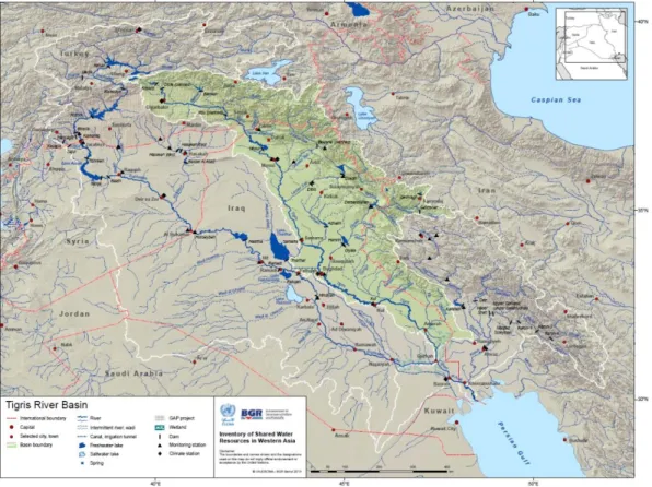
The Tigris River’s basin is about 1800 km in length and covers a total area of 473103 km2 shared by 4 countries (Figure 1 and Table 1). About 24.5% of the area of the Tigris River’s catchment lies in Turkey, while 0.4%, 19% and 56.1% lies in Syria, Iran and Iraq, respectively. The total population within the Tigris River basin reaches about 23.4 million inhabitants (ESCWA, 2013) of which 18, 3.5, 1.5 million live in Iraq, Turkey and Iran, respectively and the remainder 0.05 million live in Syria.
1Lulea University of Technology, Lulea, Sweden. 2
Figure 1: The Tigris River Basin (After ESCWA, 2013).
Table 1: The area of Tigris River Basin.
Countries
Tigris River
Catchment
area (km
2)
Catchment
area (%)
Turkey
57614
12.2
Syria
834
0.2
Iraq
253000
58
Iran
140180
29.6
Total
473103
100
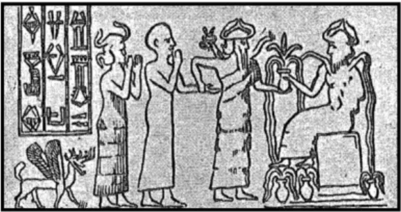
Tigris and Euphrates Rivers are well known through history. This is due to the fact that the water of these rivers had witnessed the dawn of the civilization in Mesopotamia. Irrigation and agricultural practices started in this area thousands of years ago where system of canals, dikes, weirs, and reservoirs were constructed (Kramer, 1963, Sousa, 1981, Tamnurrino, 2010). This was reflected in their historic achievements (Figures 2, 3 and 4). Canals were dug and maintained continuously and hydraulic structures were constructed, and even sanitary engineering works were performed as early as 6500B.C. (Tamnurrino, 2010). Despite the prosperity and wealth of the region, there were waves of conflicts during the history of the region, which was reflected through myths, legends and historical accounts, e.g. Epic of Gilgamesh, and attacks on water supply systems during wars was very common (Gleick, 1994; George, 2000). After this period and until the nineteenth century, the area showed more and more dependence on irrigated agriculture for its survival and more rural society was noticed.
Fig 2: The Goddess “Boa” holding two stalks of wheat with three bearded attendants the last of them in stalks of wheat (after Sousa, 1981).
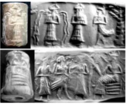
Fig 3: Sumerian women-peasant holding a winnowing pitchfork as depicted on a marble slab dating from the middle of the third millennium B.C. discovered at Nippur, Iraq
Fig 4: Seals with the representation of the water god Enki – Ea. Upper image: Old Babylonian seal (ca. 1700 B.C.). The god with water flowing from his shoulders. Lower image: Akkadian cylinder seal (ca. 2300 B.C.). The god seated on a stool and holding up
a jar from which waterspouts and falls (after Tamnurrino, A., 2010).
Recently, the Middle East area has been experiencing water shortage problems. Most of the countries of this region have acute water scarcity problem and the allocation per capita is less than 500 m3 (Roger and Lydon, 1994; Biswas, 1994; Allan, 2001; Al-Ansari, 1998, 2013, 2016; Cherfance and Kim, 2012; Barr et al., 2012). This is due to several reasons which includes:
a. High population growth rate. b. Improved standard of living. c. Effect of climate change.
d. Construction of huge hydraulic structures on the rivers’ water courses. For these reasons, the conflict and friction among neighboring countries had risen at different times related to water sharing.
In this work, hydrological conditions of the Tigris River’s catchment area will be addressed. This will give a good insight on the present conditions and can be used to solve ongoing problems.
2 Climate
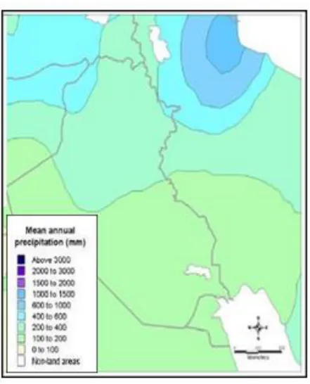
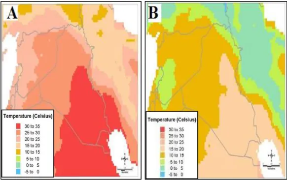
In the headwater area of the Tigris basin, the weather in summer is dry; while it is cold and wet during winter. Precipitation dominates during autumn, winter and spring seasons and snow fall takes place during winter. The climate in Turkey is of Mediterranean type and gradually changes toward the south to hot and dry arid climate (Turkish Ministry of Environment, 2012; Sen et al., 2012). At the south, the precipitation hardly exceeds 1000 mm/year (Figure 5) (Al-Ansari and Knutsson, 2011; ESCWA, 2013; Al-Ansari, 2013; Al-Ansari et al., 2014a). The temperature varies from -35○ C in winter at the northern parts of the basin and goes up to 50○ C during summer at the southern part of the basin (Figure 6).
Figure 5: Mean annual precipitation in the Tigris and Euphrates Basins
http://images.search.yahoo.com/search/images?_adv_prop=image&fr=yfp-t-621&va=Ma ps+of+climate+of+Iraq
Figure 6: Maximum, A and minimum B, daily temperature in the Tigris and Euphrates basins.
,http://images.search.yahoo.com/search/images?_adv_prop=image&fr=yfp-t-621&va=Ma ps+of+climate+of+Iraq
3 Course of the Euphrates River
The Tigris River rises at Taurus Mountains near the city of Elazig at the Armenian Highlands. It is 1800 km long, which makes it the second longest river in Western Asia. The river starts with small tributaries that join together to form two main tributaries. These are:
- Batman Su or Dijla Su. This tributary rises at altitude up to 4500 m (a.s.l.) and it runs from the west toward the east.
- Botan Su: It rises at altitude up to 1500 m (a.s.l.) and it is comprised of several small tributaries that originate near Van lake.
Table 2: Main tributaries of the River Tigris
The river runs 400 km in Turkey and it forms the Turkish- Syrian border for about 47 km, then it flows inside Iraq for about 1400 km. The mean annual flow of the river in Turkey reaches 20.3X 10⁹ m3/y (Kliot, 1994; Kolars,1994; Kurdish Human Rights Project, 2002; Biedler, 2004; ESCWA, 2013). The rivers enter Iraq near Zakho town. Inside Iraq, the first tributary “Feesh Khabour” joins the River Tigris near the city Zakho. Al-Khabur catchment area reaches 6143 km2 shared between Turkey (3477 km2) and Iraq (2666 km2). The total length of the river is 181 km with a mean annual flow of 2 billion cubic meters (BCM) (Table 2), while the minimum and maximum flows reach 0.9 and 4.3 BCM, respectively. It originates at Sirnak in the eastern Turkey. The river flows south towards Iraq and is joined by its main tributary Hezil Suyu, which forms the Turkish- Iraqi border for about 20 km and then merges with the Tigris at the tripoint of the three countries (Turkey, Syria, Iraq) (ESCWA, 2013).
After the confluence with the Khabur, the River Tigris runs south for about 188 km and it reaches one of the main cities “Mosul”. At Mosul, the average, maximum and minimum discharges of the river is 668 m3/s, 7,740 m3/s, 2/5/1972, and 85 m3/s, October, 1935, respectively and the elevation of the channel bed is 225 m (a.s.l.). Further south for about 50 km, the Tigris joins its largest tributary “Greater Zab” near the city of Shirqat. This tributary has a total length of 462 km and it originates in Turkey and drains a catchment area of 26310 km2 of which 9209 km2 (35%) lies in Turkey and the remainder in Iraq. This tributary contributes about 33% of the Tigris flow. The Tigris River then flows south, and 30 km before it reaches Al-Fatha gorge, the Lesser Zab (Little Zab) joins the river. This tributary is 456 km in length and drains an area of 19,780km2 of which 24% lies in Iran and the remainder 76% lies in Iraq.
The mean, minimum and maximum annual flows of the river are 6.0, 1.7 and
River Catchment (km2) Length (km)
Flow (BCM) Total Turkey Iran Iraq Mean
Annual Minimum Maximum Feesh Khabur 6143 57% - 43% 181 2.0 0.9 4.3 Greater Zab 26310 35% 65% 462 12.7 3.7 23.6 Lesser Zab 19,780 - 24% 76% 456 6.0 1.7 15.1 Al-Adhaim 13,000 - - 100% 330 0.79 0.08 1.85 Diyala 33,240 - 25% 75% 445 4.6 1.2 14.4
Source of data: ESCWA, 2013; Mahmoud, 2010 ; Ministry of Water Resources in Iraq, 2012; USGS, 2012
15.1 BCM, respectively. Two dams were constructed on this tributary. The first one is referred to as Dokan Dam, which is located in the upper part of the catchment in Iraq; approximately 60 km north-west of the city of Sulaimaniyah. It is a concrete arch multipurpose dam. This dam was put into operation in 1959. The second is known as Dibis Dam, is an embankment dam located about 130 km upstream of the confluence of the Lesser Zab with the River Tigris and it was put into operation in 1965. Its main function is to divert the Lesser Zab water to Kirkuk irrigation scheme.
South of Al-Fatha gorge, the River Tigris enters the Mesopotamian Plain. When the river reaches Samara city, a barrage was constructed in 1956. The main purpose of this barrage is flood control by diverting excess water from the Tigris River to Tharthar Lake and generate electricity. Further downstream, Al-Adhaim tributary joins the Tigris River 15 km south of Balad city. This tributary is about 330 km long and drains an area of 13000 km2 which lies entirely in Iraq. It is an intermittent river having mean, minimum and maximum annual flows of 0.79, 0.08 and 1.85 BCM, respectively. An embankment dam was constructed on this tributary for flood control, hydro-power and irrigation and it started operating in 2000.
The Tigris River flows further south till it reaches the capital Baghdad. At Baghdad the mean, maximum and minimum discharges are 1,140m3/s, 7,640 m3/s on 12/2/1941 and 163m3/s in October, 1955, respectively. South of Baghdad (about 30 km), the Diyala tributary joins the Tigris River. This tributary is about 445 km long and drains an area of 33,240 km2. About 20% of its drainage area lies in Iran and the remainder in Iraq. The mean, minimum and maximum flows of this tributary are 4.6, 1.2 and 14.4 BCM, respectively.
Downstream of this confluence, the Tigris River channel is characterized by its large number of meanders and its discharge decreases downstream due to different kind of losses which include evaporation, infiltration and mainly water withdrawal through irrigation canals. Several irrigation canals are supplied by the Tigris River. These are Gharraf, Dujalia and Hussaynia south of Kut city, Great Majar south of Emarah city, Mushrah, Kahlaa and Mejariah South of Qalaat Salih. Large marshes used to be on both sides of the Tigris channel in its southern stretch. Nowadays, these marshes occupy relatively small areas due to water scarcity. Several small streams running from Iran discharge their water to the Tigris River during rainy periods. The most important streams are Tib (or Teeb), Dewarege and Shehabi. These streams drain an area of about 8000 km2 and they provide 1.0 BCM of water annually, which ends into the marshes (Abdullah, 2016). South of Amarah city, the Tigris River reaches its minimum with at Kasarah area. The River joins the Euphrates River at Qurnah city and its mean daily discharge before this confluence reaches 80 m3/s at Amrah.
4 Flow Characteristics of the Tigris River
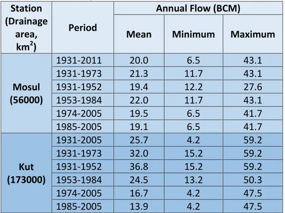
Flow of the River Tigris can be considered as natural before 1973 where no dams were constructed within the northern part of the catchment. After that, a number of dams were built in the Turkish part of the catchment as well as in Iraq. ESCWA (2013) analyzed the annual flow volume of the Tigris River at two stations (Table 3). One of the stations (Mosul), which is located northern part of Iraq and the second station (Kut) located in the southern part of Iraq (Figure1). The flow of the Tigris River at Mosul station for the period 1931-1973 represents natural flow because no dams were constructed on the river upstream this station. The flow for the period 1974-2005 was affected by the construction of dams after the 1990’s. The overall mean annual flow for the period of the record was 20 and 25.7 BCM at Mosul and Kut stations, respectively (Table 3). The maximum and minimum flows at Mosul were 43.1 BCM (1969) and 6.5 BCM (1999), respectively, while it was at Kut station 59.2 BCM (1946) and 4.2 BCM (2001), respectively. It should be mentioned; however, that the tributaries of the Tigris River downstream Mosul station contribute about 50% of the Tigris flow at Baghdad (ACSAD and UNEP-ROWA, 2001 and Shahin, 2007). Taking this into consideration, then it can be noticed that, the flow of the river is decreasing downstream toward Kut. This is due to large scale extraction for municipal, industrial and agricultural purposes.
The mean annual discharge of the Tigris River at Mosul station for the period 1931 to 2011 does not show any trend while a negative trend is recognized at Kut station (Figure 7). A negative trend can be recognized at Baghdad station (Figure 8). The records indicate that the discharge of the Tigris River for the period 1931-1960 where no dams were constructed on the river reached 1,207 m3/s. Following that period (1961-2000), some dams were constructed on the river and its tributaries, which caused decrease of the discharge to 927 m3/s (Al-Ansari et al., 2015). The annual water flow of the river decreased by 2.8% between the 1950’s and 1960’s and this trend continued where the flow of the river reached 715 m3/s from 1980 onwards. This is mainly due to the construction of dams and climate change (Al-Ansari et al., 2015). Further reduction in the flow was noticed after the year 2000, where the discharge of the river at Baghdad reached 522 m3/s; due to the construction of dams in Turkey and Iraq, and diversion water coming from the valleys in Iran to the river inside Iranian borders. Analysis of the records for the past 60 years suggest that the annual flow of the river was reduced by 59.3% (Al-Ansari et al., 2015).
Table 3: Summary of annual flow of the River Tigris at Mosul and Kut stations (modified after ESCWA, 2013).
Station
(Drainage
area,
km
2)
Period
Annual Flow (BCM)
Mean
Minimum
Maximum
Mosul
(56000)
1931-2011
20.0
6.5
43.1
1931-1973
21.3
11.7
43.1
1931-1952
19.4
12.2
27.6
1953-1984
22.0
11.7
43.1
1974-2005
19.5
6.5
41.7
1985-2005
19.1
6.5
41.7
Kut
(173000)
1931-2005
25.7
4.2
59.2
1931-1973
32.0
15.2
59.2
1931-1952
36.8
15.2
59.2
1953-1984
24.5
13.2
50.3
1974-2005
16.7
4.2
47.5
1985-2005
13.9
4.2
47.5
Figure 7: Mean annual discharge of the Tigris River at Mosul and Kut stations (modified after ESCWA, 2013).
Figure 8: Mean annual flow variation of the Tigris River at Baghdad station for the period 1933 to 2011 (modified after Abdullah, 2016)
The maximum flow of the Tigris River takes place during April - May period (Figure 9). The discharge varies according to the meteorological conditions mainly the intensity and duration of rainfall events during the period October to February and is known as variable flood period. The following period (March – April) is characterized by relatively steady discharge due to snow melt in the upper catchment area in Turkey and northern Iraq, and is known as steady flood period. It is clear that the hydrograph of the river is becoming flatter with time (Figure 9). This reflects the effect of dams’ construction in the upper parts of the catchment and draught that is affecting the Middle East area due to climate change (Al-Ansari et al., 2014a).
5 Water Schemes and Projects
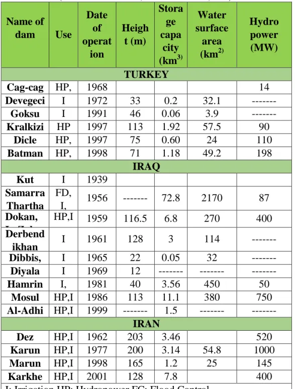
Projects in the upper parts of the Tigris River basin started in the early 1930’s in Turkey mainly for flow regulations. In the 1940’s; however, projects for the production of electricity using hydroelectric power mainly in addition to limited irrigation practices were developed (Ozis, 1983; ESCWA, 2013). Later, during the 1970’s, the Turkish Government started what is known as Southeastern Anatolia Project (GAP). According to this project, 22 dams and 19 hydraulic power plants which are supposed to irrigate 17,000 km2 of land are to be constructed (Olcay Unver, 1997; GAP, 2006). According to this project, some of the dams are to be constructed on the Tigris River (Table 4) to irrigate about 600000 ha using 5.6 BCM (ESCWA, 2013).
Dam. When this dam operates, then, Iraq will receive only 9.7 BCM of water (Alalaf, 2009), which means that the decrease of flow will be 47% (Al-Ansari, 2016). As a consequence, and due to water scarcity, 696000 ha of agricultural land will be abandoned (Al-Ansari and Knutsson, 2011). EsCWA (2013) stated that Turkey controls about 33% of the Tigris River total flow and its utilization of water is increasing with time and it can theoretically use the Greater Zab River water also.
Figure 9: Decadal hydrographs of the Tigris River at Sarai Baghdad for the period 1930-2013 (source of data: Al-Shahrabaly, 2008).
0 500 1000 1500 2000 2500 3000 3500 O ct. No v. De c. Ja n . Feb. Mar . A p r. M ay Jun e Jul y A u g. Se p t. Di sc ha rg e (m³ /s) Month 1930s 1940s 1950s 1960s 1970s 1980s 1990s 2000s
Table 4: The constructed dams in the basin of the Tigris River (modified after ESCWA, 2013 and Issa et al., 2014).
Name of
dam
Use
Date
of
operat
ion
Heigh
t (m)
Stora
ge
capa
city
(km
3)Water
surface
area
(km
2)Hydro
power
(MW)
TURKEY
Cag-cag HP,
FC
1968
14
Devegeci
di
I
1972
33
0.2
32.1
---
Goksu
I
1991
46
0.06
3.9
---
Kralkizi
HP
1997
113
1.92
57.5
90
Dicle
HP,
I
1997
75
0.60
24
110
Batman
HP,
I
1998
71
1.18
49.2
198
IRAQ
Kut
Barrage
I
1939
Samarra
Thartha
r
FD,
I,
HP
1956
---
72.8
2170
87
Dokan,
L. Zab
HP,I
1959
116.5
6.8
270
400
Derbend
ikhan
Diyala,
I
1961
128
3
114
---
Dibbis,
L. Zab
I
1965
22
0.05
32
---
Diyala
I
1969
12
---
---
---
Hamrin
,Diyala,
I,
FC
1981
40
3.56
450
50
Mosul
HP,I
,FC
1986
113
11.1
380
750
Al-Adhi
m
HP,I
1999
---
1.5
---
---
IRAN
Dez
HP,I
1962
203
3.46
520
Karun
HP,I
1977
200
3.14
54.8
1000
Marun
HP,I
1998
165
1.2
25
145
Karkhe
h
HP,I
,FC
2001
128
7.8
400
The use of the Tigris water is very limited in Syria. This is due to the fact that the Tigris River forms a small stretch of the Turkish- Syrian border. Syria is using 1.25 BCM annually to irrigate 15000 ha of land in Hasakah Governorate based on an agreement with Iraq in 2002 (ESCWA, 2013).
Iran is suffering from drought where plenty of villages have no water supply and some of the lakes became dry (Sharifikia, 2013, Al-Shaab, 2017, Proyect, 2018). For this reason, Iran diverted most of the valleys supplying water to the Tigris River and its tributaries and constructed several dams for the same purpose (Table 4). Recently, Karkha and Karun Rivers had been almost completely diverted inside the Iranian borders.
Iraq was the first riparian country to use the water of the Tigris River by constructing barrages and dams since 1939 (Table 4). Regulation of flow and flood control was the main goal of the early projects. One of the earlier projects is Tharthar barrage and canal, which is located north-west of Baghdad. This project, which was completed in 1977, is to divert excess water from the Tigris River to Tharthar Depression (Figure 10). This project helped in overcoming the water shortage problems in the flow of the Euphrates River; where water from the Tigris River was diverted to the Euphrates River via Tharthar Lake. In addition, Iraq constructed what is known as the Third River to collect drainage water from 1.5 million ha of agricultural land (FAO, 2003). Other projects were constructed on the Tigris River and its tributaries (Table 4 and Figure 10) to irrigate about 4 million ha (ESCWA, 2013).
Spring flood of the Tigris River and its tributaries normally causes plenty of problems for the agricultural practices due to the large quantities of carried silt and clay (Al-Ansari, 2013 and 2016; Al-Ansari et al., 2014b and 2015). The nature of the topography in the lower parts of the Tigris basin in Iraq is very flat and poorly drained which has caused number of problems including flooding, siltion and soil salinity. For these reasons, the focus of the Iraqi authorities concerned was directed towards land reclamation where 1 million ha of land was reclaimed and another 1.5 million ha was semi-reclaimed (Ministry of Planning in Iraq, 2010). New reclamation projects were planned for 920000 ha and irrigation of 134000 ha (FAO, 2008).
Figure 10: Schematic Diagram of the Tigris River Hydrological Scheme (MWR, 2005).
6 Discussion
Most of the Middle East considered as arid to semi-arid area. The countries in this region suffer from water shortage problems for a long time (Al-Ansari, 1998, 2013; Shahin, 2007; Roger and Lydon, 1994; Biswas, 1994). The Middle East is experiencing drought problems due to climate change. Most of the countries of the region, which suffer are vulnerable to the impact of this change (IPCC, 2007; Arab Forum for Environment and Development; AFED, 2009). The problem is intensifying with time due to high rate of population growth and development (Shahin, 2007). Future expectations are more negative where the region is to suffer from high temperatures and lower rainfall (Al-Ansari and Baban, 2005; Al-Ansari et al., 1999, 2006). Such conditions will enhance drought and flooding. As a result of such meteorological conditions, agricultural life and water supply will be highly affected (Medany, 2008), where most of the areas in this region are rain fed. In addition, groundwater resources will be depleting due to low recharge (Voss et al., 2013).
The high rate of population growth and droughts forced the riparian countries to use all possible ways and means to augment their water resources. To achieve this goal, new dams were planned and constructed (Table 5). Many
City Dam Barrage Regulator Natural River Irrigation Canal Baghdad Mosul Iraq–Turkey Border Mosul Dokan Derbendi Khan Hemrin Al-Adhai m Khabour Greater Zab Lesser Zab Al Khazir Diyala Weir Diyala River Samarra Adhaim Tributary
Flood Escape Channel
Tharthar-Tigris Canal Tharthar Lake Tigris River Fatha/Baji Duhok Ira q – Ir a n B o rd er Dibs T ig ri s R iv er To Kut Iraq – Ir an B or d er
irrigation projects were implemented so that they can attain food self-sufficiency. As a consequence, water quantity of the Tigris River available to Iraq is decreasing with time. The increase in salinity caused soil degradation due to intensive irrigation and high rates of evaporation. It should be mentioned; however, that in the upper parts of the catchment (Turkey) the salinity is still acceptable (Odemis and Evrendilek, 2007). Other sources of pollution in the Tigris River is the untreated wastewater that is dumped directly in the river (Al-Hamdani, 2013; Varol et al., 2011). The salinity of the river reaches 300 ppm when the river enters Iraq and it increases gradually downstream where it reaches 1318 pp in Amarah city (see Al-Shujairi, 2013; ESCWA, 2013). Iraq is highly affected where 98% of the population in this part of the basin depends on the Tigris water for drinking and irrigation. Furthermore, in case Turkey and Syria keep implementing irrigation projects and dams to meet the growing demand for water, this will lead to dry up the Tigris and Euphrates Rivers by 2040 (UN, 2010).
It is a clear fact that, water resources represent an extremely important factor in the stability of the region and an integral element in its economic development and prosperity (Naff, 1993; Al-Ansari, 1998; 2005; 2016). Recently, Iraq has been experiencing very hard water shortage problems where the Tigris flow drastically has decreased and there is almost no flow in the river at Amarah city in the south (Figure 11). Such a situation will definitely lead to human and environmental crises. To solve this conflict, it requires plenty of regional cooperation as well as prudent water managem.
7 Conclusions
The Tigris River flow is decreasing with time. This is due to the effect of various variables. Among these are: climate change, which is causing droughts, depletion of groundwater resources and floods, and the large scale development in the upper catchment in the form of constructing new dams and irrigation projects. High population growth rates and these developments in the region caused more need for water resources. Riparian countries planned and constructed various dams and irrigation projects. Intensive irrigation and high rates of evaporation caused increase in the salinity of the Tigris water downstream. In addition, dumping wastewater directly to the river caused water pollution. Iraq is the most affected country because it is the downstream riparian country.
To overcome these problems, it requires intensive regional and national cooperation and work. Agreements for cooperation and agreement on water quotas should be reached by the riparian countries and cooperation is also needed to preserve and improve the quality of the Tigris River water. On national level, public awareness program is to be implemented as well as prudent water management planning. New water conservation irrigation techniques are to be adopted.
Table 5: Planned dams on the River Tigris (modified After ESCWA, 2013)
Name Capacity
(BCM) Purpose Status Information
TURKEY Ilisu 10.41 HP Construction started in 2006, but was suspended in 2008. Work resumed in March 2010. Planned hydropower capacity: 1,200 MW Projected irrigated area: 313,000 ha Cizre 0.36 HP Construction was to begin in June 2008. Completion scheduled: 2017.
The downstream Cizre Dam will work in parallel with the Ilisu Dam. Planned hydropower capacity: 240 MW
Projected irrigated area: 121,000 ha Silvan .. HP Construction started in 2012. Planned hydropower capacity: 150 MW
Kayseri .. HP Master plan
completed. Planned hydropower capacity: 90 MW IRAQ Badush 10,000 HP Partially constructed. Planned hydropower capacity: 170 MW Bekhme Dam (Greater Zab) 17,000 HP Partially constructed Planned hydropower capacity: 150 MW Mandawa (Greater Zab) .. HP, I .. .. Taq Taq (Lesser Zab) .. HP, I .. .. HP: Hydropower I: Irrigation
Figure 11: Tigris River at Amara City (February, 2018)
References
[1] Abdullah, A.D., 2016, Modelling Approaches to Understand Salinity Variations in a Highly Dynamic Tidal River: The case of the Shatt Al-Arab River, PhD thesis, Delft University of Technology and of the Academic Board of the UNESCO-IHE Institute for Water Education
[2] ACSAD and UNEP-ROWA (Arab Center for the Studies of Arid Zones and Dry Lands; United Nations Environment Programme- Regional Office for West Asia), 2001, Surface Water Resources in the Euphrates and Tigris River Basin. Unpublished.
[3] Alalaf, I., 2009, Ilisu dam and its effect on man and environment in Iraq and Turkey, Batnaya. Available at:
http://www.batnaya.net/forum/showthread.php?s=9bd97aa8bfae0b9b35554d 8ce6c2787e&p=151263#post151263 Lastaccessed January, 2018.
[4] Al-Ansari, N. ,1998. Water Resources in the Arab countries: problems and possible solutions, UNESCO International Conference on World Water Resources at the Beginning of the 21st Century 3-6 June, Paris, 1998, 367-376. [5] Al-Ansari, N.A., Salameh, E. and Al-Omari, I., 1999. Analysis of Rainfall in
the Badia Region, Jordan, Al-Bayt University Research paper No.1, 66p. [6] Al-Ansari, N.A., 2005, Applied surface Hydrology, Al al-Bayt University
publication, Mafraq, Jordan.
[7] Al-Ansari, N.A., Al-Shamali, B. and Shatnawi, A., 2006. Statistical analysis at three major meteorological stations in Jordan, Al Manara Journal for scientific studies and research, 12, 93-120
[8] Al-Ansari, N.A, 2013. Management of Water Resources in Iraq: Perspectives and Prognoses, J. Engineering, 5,8, 667-684.
[9] Al-Ansari, N.A., 2016. Hydro-Politics of the Tigris and Euphrates Basins, Engineering, 8, 3, 140-172.
[10] Al-Ansari, N.A. and Baban, S., 2005. Rainfall Trends in the Badia Region of Jordan, Surveying and Land Information Science, 65,4, 233-243.
[11] Al-Ansari, N.A., Ali, A., Al-Suhail, Q. & Knutsson, S., 2015, Flow of River Tigris & its Effect on the Bed Sediment within Baghdad, Iraq. Open Engineering, 5, 465–477.
[12] Al-Ansari, N.A., Ali, A. and Knutsson, S., 2014a. Present conditions and Future Challenges of Water Resources Problems in Iraq, J. Water Resources and Protection, 6, 12, 1066-1098.
[13] Al-Ansari, N.A., Ibrahiem, N., Alsaman, M. and Knutsson, S., 2014b, Water Demand Management in Jordan, J. Engineering, V.6, No.1, 19-26.
[14] Al-Ansari, N.A. and Knutsson, S., 2011, Toward Prudent management of Water Resources in Iraq, J. Advanced Science and Engineering Research, 1,53-67.
[15] Al-Hamdani, F.Z., 2013, Water pollution in Iraq between disastrous border and no real solutions, A study, J.l of Genetic and Environmental Resources Conservation, 2013,1,2,111-118.
[16] Al-Shaab, T., 2017. Interview with the Iraqi Minister of Water Resources, 22nd June, 2017, Issue number 212, year 82. Available at: http://tareeqashaab.com/images/TariqPDF/2017/6/22.pdf last accessed 30 January, 2018.
[17] Al-Shahrabaly, Q.M., 2008. River discharges for Tigris and Euphrates gauging stations. Ministry of Water Resources, Baghdad (in Arabic).
[18] Al-Shujairi, S.O., 2013, Develop and Apply Water Quality Index to Evaluate Water Quality of Tigris and Euphrates Rivers in Iraq, International Journal of Modern Engineering Research, 3,4,2119-2126
[19] Biedler, M., 2004. Hydropolitics of the Tigris-Euphrates River Basin with Implications for the European Union. CERIS Research Papers N1. https://aquaknow.jrc.ec.europa.eu/document/hydropolitics-tigris-euphrates-ri ver-basin-implications-european-union
[20] Biswas, A.K. (ed.) ,1994. International Waters of the Middle East– From Euphrates, Tigris to Nile. Bombay, India, Oxford.
[21] Cherfane, C.C. and Kim, S.E. ,2012, Arab Region and Western Asia, UNESCWA. Managing Water under Uncertainty and Risk, UN World Water Development Report 4, Chapter 33.
[22] ESCWA, Economic and Social Commission for Western Asia, 2013. Inventory of Shared Water Resources in Western Asia, Salim Dabbous Printing Co., Beirut, Lebanon, 626p.
[23] FAO (Food and Agriculture Organization of the United Nations). 2003. Towards Sustainable Agricultural Development in Iraq. Published by Emergency Operations and Rehabilitation Division Special Emergency Programmes Service. Available at:
http://www.fao.org/docrep/006/y9870e/y9870e00.htm#Contents. Accessed on January 29, 2018.
[24] FAO (Food and Agriculture Organization of the United Nations). 2008. From Emergency to Development. In Medium Term Strategy from FAO Assistance to Iraq. Available at:
http://www.fao.org/fileadmin/templates/tc/tce/pdf/Iraq_Strategy_14_April20 08__final_.pdf Accessed on January 29, 2018.
[25] GAP (South-eastern Anatolia Project), 2006, What is GAP, Regional Development Administration, South Anatolia Project, Turkish Ministry of Development. http://www.gap.gov.tr/en/ Last accessed 29th January, 2018. [26] George, A., 2000. The Epic of Gilgamesh, The Babylonian Epic Poem and
Other Texts in Akkadian and Sumerian, Published by the Penguin Group, England. http://www.cidmod.org/sidurisadvice/Gilgamesh.pdf Last accessed June 16, 2017.
[27] Gleick, P. ,1994. Water, war and peace in the Middle East, Environment Magazine, 39, 6–42.
[28] IPCC (Intergovernmental Panel on Climate Change), 2007. Climate change impacts, adaptation and vulnerability”. Cambridge University Press, Geneva. [29] Kliot, N., 1994. Water Resources and Conflict in the Middle East. Routledge,
London.
[30] Kolars, J. ,1994. Problems of International River Management: The Case of the Euphrates. In: Biswas, A.K., Ed., International Water of Middle East from Euphrates-Tigris to Nile. Water Resources Management Series 2, Oxford University Press, Oxford, 45-94.
[31] Kramer, S.N., 1963, The Sumerians: their history, culture and character, The University of Chicago Press, Chicago, 385p.
[32] Kurdish Human Rights Project, 2002. Downstream Impacts of Turkish Dam Construction on Syria and Iraq, Joint Report of Fact-Finding Mission to Syria and Iraq, The Ilisu Dam Campaign, The Corner House. http://www.thecornerhouse.org.uk/sites/thecornerhouse.org.uk/files/IraqSyri. pdf
[33] Medany, M., 2008. Impact of Climate Change on Arab Countries, Chapter 9, www.afedonline.org/afedreport/english/book9.pdf
[34] Mahmoud, F.A., 2010. Surface Water Resources of Euphrates and Tigris Rivers Basins in Iraq, M. Sc. Dissertation, College of National Defense, University of National Defense, Baghdad, Iraq.
[35] Ministry of Planning in Iraq, 2010. National Development Plan for the Years 2010-2014, Baghdad. Available at:
http://www.unesco.org/education/edurights/media/docs/795ff8cb2cd3987aba 07572026cdb6d0958cd27a.pdf Accessed on January 29, 2018.
[36] Ministry of Water Resources - Iraq, MWR, 2005. Schematic diagram of main control structures in Iraq, General directorate of water resources management, hydrological studies Centre: Baghdad.
[37] Naff, T. ,1993. Conflict and water use in the Middle East, , in Roger, R. and Lydon, P. (Ed.), Water in the Arab Word: Perspectives and Prognoses, Harvard University, 253-284.
[38] Odemis, B. and Evrendilek, F., 2007. Monitoring Water Quality and Quantity of National Watersheds in Turkey, Environmental Monitoring and Assessment, 133, 215-229.
[39] Olcay Unver, I.H. ,1997. Southeastern Anatolia Project (GAP), International Journal of Water Resources Development, 13, 4, 453 – 484.
[40] Ozis, U. ,1983. Development Plan of the Western Tigris Basin in Turkey. Water Resources Development, 1,4, p. 343-352.
[41] Proyect, L., 2018, Iran`s Water Crisis, Counter punch, January 10, 2018. Available at: https://www.counterpunch.org/2018/01/10/irans-water-crisis/ last accessed 30 January, 2018.
[42] Roger, P. and Lydon, P. ,1994. (eds.) Water in the Arab World, Massachusetts, USA: Harvard University Press. University Press, 1994.
[43] Sen B., Topcu S., Türkes M., Sen B. and Warner J.F., 2012. Projecting climate change, drought conditions and crop productivity in Turkey, Climate Research, 52, 175-191.
[44] Shahin, M., 2007. Water Resources and Hydrometeorology of the Arab Region. In Water Science and Technology Library, Volume 59 Published by Springer. Dordrecht.
[45] Sharifikia, M., 2013.Environmental challenges and drought hazard assessment of Hamoun Desert Lake in Sistan region, Iran, based on the time series of satellite imagery, J. Natural Hazards, 65, 201-217, DOI 10.1007/s11069-012-0353-8
[46] Sousa, A., 1981. History of Mesopotamian Civilization, Part 1, Ministry of Irrigation press, Baghdad, Iraq.
[47] Tamnurrino, A., 2010. Water Technology in Ancient Mesopotamia, Chapter 2, 29-51, in Mays L.W. (ed.) Ancient Water Technologies, Springer DOI 10.1007/978-90-481-8632-7
[48] Turkish Ministry of Environment, 2012. Turkey’s National Climate Change Adaptation Strategy and Action Plan. Available at:
http://www.dsi.gov.tr/docs/iklim-degisikligi/turkeys-national-climate-change -adaptation-strategy-and-action-plan.pdf?sfvrsn=2
[49] UN, 2010. Water Resources Management White Paper, United Nations Assistance Mission for Iraq, United Nations Country Team in Iraq, 20 p. http://iq.one.un.org/documents/100/white%20paper-eng_Small.pdf Last accessed August 10, 2017.
[50] USGS (United States Geological Survey), 2012. Stream Gage Descriptions and Streamflow Statistics for Sites in the Tigris River and Euphrates River
Basins, Iraq. In Data Series 540. Available at:
https://pubs.usgs.gov/ds/540/pdf/ds540.pdf . Accessed on January 18, 2018. [51] Varol, M., Gotkot, B., Bekleyen, A. and Sen, B., 2011. Water Quality
Assessment and Apportionment of Pollution Sources of Tigris River (Turkey) Using Multivariate Statistical Techniques, Journal of Hazardous Materials, 195,355-364.
[52] Voss, K.A., Famiglietti, J.S., Lo, M.H., Linage, C., Rodell, M. and Swenson, S., 2013. Groundwater depletion in the Middle East from GRACE with implications for transboundary water management in the Tigris-Euphrates-Western Iran region, Water Resources Research, .49, 2, 904-914.