Scientific Press International Limited
How Dams Can Affect Freshwater Issues in the
Euphrates-Tigris Basins
Nasrat Adamo1, Nadhir Al-Ansari2 and Varoujan K. Sissakian3
Abstract
The basins of the Tigris and Euphrates Rivers Cover an area of 917103km2 distributed between Iraq, Turkey, Iran, Syria and Saudi Araba. The population within the basins reaches about 50 million inhabitants. The flow of the two rivers is decreasing with time. This is due to the construction of dams and irrigation projects in the upper parts of the basins and climate change. This has an impact on the quality of water within the two rivers. Iraq being the lowest riparian country is highly effected. Analysis of water quality of the water indicates that the salinity of Euphrates water is increasing with time and on the Syrian- Iraqi borders, it is of unacceptable level where it is higher than what is recommended for Irrigation. The Tigris water quality becomes alarming once the river enters Iraq and at Baghdad, it becomes unsuitable for irrigation. To overcome these problems, riparian countries must cooperate seriously to take measures to improve the quality of water within the two rivers.
Keywords: Tigris, Euphrates, Dams, Iraq.
1 Consultant Engineer, Norrköping, Sweden.
2 Lulea University of Technology, Lulea 971 87, Sweden.
3 University of Kurdistan, Hewler, KRG, Iraq. Private Consultant Geologist.
Article Info: Received: November 5, 2019. Revised: November 17, 2019.
1. Historical Notes on Dams and Irrigation Works
The first successful efforts to control the flow of water were made in Egypt and Mesopotamia; Greek for "the land between the rivers”. The Sumerians in southern Mesopotamia built city walls and temples and dug canals that were the world's first engineering works. It is also of interest that the Sumerians, from the beginning of recorded history, fought over water rights. Irrigation was extremely vital to Mesopotamia. Flooding problems; however, were more serious in Mesopotamia than in Egypt because the Tigris and Euphrates rivers carried several times more silt per unit volume of water than the Nile. This resulted in rivers rising faster and changing their courses more often in Mesopotamia [1].
The Euphrates and Tigris rivers cannot be seen as two of the major rivers of the world whether in length, volume of flow, or size of the catchment area. As rivers, mostly serve irrigation requirements so the volume of their annual stream flow may be considered as the most important variable in comparison with other rivers. In rough order of magnitude, the annual average flow volume of each of the Tigris and Euphrates rivers is only one-third that of the Rhine or the Nile, or a mere tenth of the Danube or Volga rivers. Not to speak of giants like the Amazon and Congo. They are dwarfed by large rivers like the Mississippi and Yangtze, which are more than twenty-five times of each of them. Although the Tigris annual stream flow volume surpasses that of the Euphrates by a ratio of approximately five to three, the Euphrates still compares with Colorado river in size as closest in annual stream flow volume and in serving semi-arid and arid belts and which is also sharply reduced by human use before it reaches its estuary. But it cannot be overstressed that there are few if any other river regardless of size, that have played so central and long continued role in human history. The processes leading to the world’s first civilization cannot be understood; except as creative adaptation to the priceless resources of the Tigris and Euphrates waters. In Mesopotamia, it started with the Sumerian civilization during the fourth millennia BC; and vigorous later traditions continued to build on assured food supply ensured by the two rivers. To study the full role of the two rivers in history, one must consider the whole geographic unit comprising the watershed area and their whole valley. During the third millennia and second millennia, archaeological finds from Tell Bark on the Khabour tributary and from Ancient Mari on the Euphrates in Syria show the strong relationship between these parts and Mesopotamia. There were to be sure some periods when deep socio-political divisions extended across the two rivers during Parthians, Sasanian, Umayyad an Abbasid empire. The valley of the two rivers; however, remained in other extended periods open for interregional contacts and the banks of the Tigris and Euphrates rivers were vital for heavily travelled routes between Mesopotamia and the world around the Mediterranean [2].
During the long history of development in the Mesopotamia, the two rivers often spilled their flood waters over the banks and into the surrounding plains. Their heavy loads of silt were deposited on these lands, but the coarser parts were deposited on the banks close to the rivers themselves and by so building higher
grounds in the form of Berms. As more silt was deposited on the bottom, the water level became increasingly higher than the adjacent land, which helped the settlers along the rivers to use gravity irrigation and flood their field to grow their needed food. And this is how Sumerians, Acadians and Babylonians civilizations constructed canals to carry the water further and extend the irrigated areas, which helped these civilizations to flourish, and only later on they invented water lifting devices but only to be of limited use. The two rivers; however, remained as a source of constant danger to the people living along them as destructive floods were also frequent, which caused destruction and human losses. Such catastrophic floods together with wars obliterated some of these civilizations and opened the way for others. During all these times the inhabitants had no means to stop such floods except maybe to resort to religion and prayers.
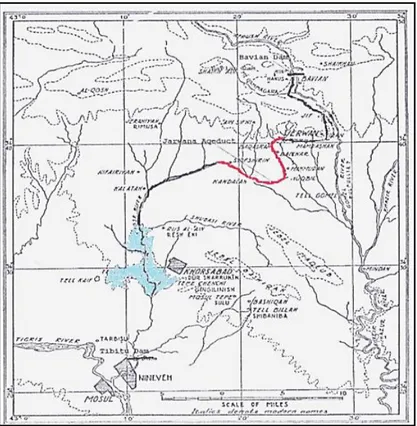
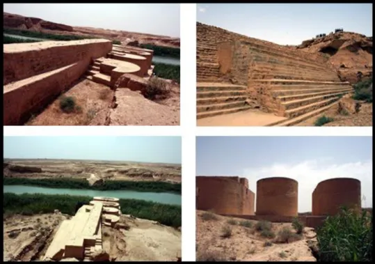
The rivers Tigris and Euphrates natural regime remained untouched by human construction activities for thousands of years, except for using some of their water resources, as already mentioned, for seasonal irrigation in some areas by building some diversion and canal works. Late after the Sumerians and Acadians, the Assyrians developed extensive public works related to irrigation and drinking water supply. Sargon's II son, the famous king Sennacherib developed waterworks by damming the Tebitu River, known today by Al- Khosar River; the perennial river out flowing into the Tigris River at the left bank of today’s city of Mosul. He then dug a canal to bring water to his capital city Nineveh, where the water could be used for irrigation and drinking water supply without hoisting devices. During high water in the spring, overflows were handled by a municipal canebrake that was built to develop marshes used as game preserves for deer and wild boar, and birch-breeding areas. When this system was outgrown, a new canal, nearly 80 kilometers long, was built, with an aqueduct that had a layer of concrete or mortar under the upper layer of stone to prevent leakage. This aqueduct (drew water from the Tigris River tributary Al Khazir – Gomal River after damming it [3] (see Figure 1). The remains of this aqueduct are still visible nowadays near the village “Jarwan” of which it took its present name.
Figure 1: King Sennacherib Dams and Irrigation Works
A major irrigation system was developed during the Sassanid and early Islamic periods in central Iraq, along the eastern banks of the Tigris River and the lower course of the Diyala River in the 6th century, which was the major canal system known Al-Nahrawan, but the first part of the irrigation works were already started during the Parthians Empire Period (247BC-224A). It reached its peak under the Abbasid Caliphate, when it served the main water supply for the Abbasid capital of Baghdad, while the regions irrigated by it served as the city's main breadbasket. Its destruction and progressive abandonment from the mid-10th century onwards mirror the Abbasid Caliphate's decline. The main Al-Nahrawan feeder canal; however, was built in the Sassanid Era in the 6th Century and drew water from the Tigris River near Samarra or from its other intake near Baiji depending on the seasonal height of the water in the Tigris River, and it carried water to the Diyala River near the present city of Ba'quba. It utilized the river course for some distance before it crossed it and continued further down in the direction of Kut as indicated by the mounds and old remains still visible up to these days (Figure 2). It is believed that the crossing of the Diyala River was accomplished by building a diversion weir called “Shirwan Dam” [4].
Figure 2: Photograph of the remains of Al-Nahrawan canal near Ba’quba taken by Gertrud Bell ([4]).
Meanwhile, the canal was joined by three smaller canals taken from the Tigris River, the Yahudi ("of the Jews"), the Al-Ma'muni, named after Caliph Al-Ma'mun (reign, 813–833), and the largest of the three, the Abu 'l-Jund "arch warrior", built under Harun al-Rashid (reign, 786–809) [4]. In its course (Al-Nahrawan), it intersects with the Al-Adhaim River and the river itself, which was utilized to carry the canal’s flow further down until a location where a dam was built to divert the channel’s flow to the left side reaching in its way to Ba'quba city as indicated previously. The remains of this dam, called nowadays the “Abbasid Dam” still exist on Al-Adhaim River and which are shown in Figure 3.
Figure 3: The remains of the Abbasid Dam, which still exist on Al-Adhaim River.
Two more dams were built during the Abbasid Era on the Tigris River, northwest of Bagdad city to divert water to some main arteries serving the areas around Baghdad. The first of which was called “Al-Dujail” to distribute water by extensive network to irrigate orchards, and the second at the outskirts of Bagdad called “Karkhaya” with other channels called “Al-Shawar’a and “Al-Douroub” to transport water to the orchards of Baghdad in winter and summer. In this extensive network, another dam was constructed to supply water to Nahir Essa (Essa River), Another dam was also built near Saqlawiah on the Euphrates to draw water for Irrigating the Orchards of Baghdad which remains up to date and passes in the western part of the city of Bagdad and recognized by the name of Nahir Al-Khir (Al-Khir River) [5]. From the foregoing, it is clear that the impact of the Tigris and Euphrates Rivers on human history was great one, and the application their fresh water to irrigate the land brought with it the first seeds of human civilization.
2. Dams on the Tigris and Euphrates Rivers and Fresh water
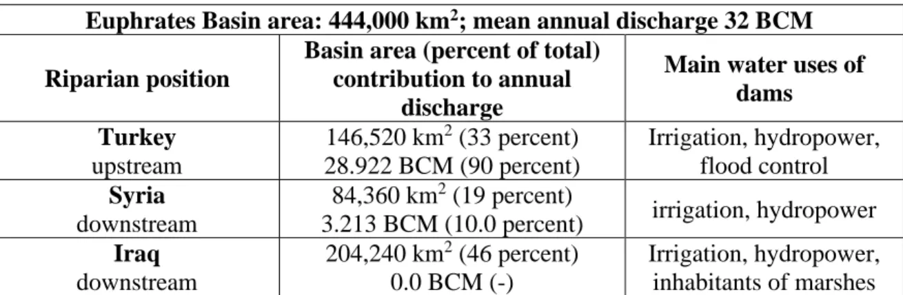
The Rivers Tigris and Euphrates form the main water resources of Iraq. This country was considered as freshwater rich throughout history. In spite of the intense seasonal and yearly fluctuations of the flow of the two rivers, their water helped establish and advance ancient civilizations such as the Hattian culture (2000-1700BC) and Hittites culture (1600-1350 BC) in Anatolia, Sumerian an Akkadian cultures in south Mesopotamia (4500-2154 BC), Babylonian culture in central Mesopotamia (1735-1499 BC) and Assyrian culture in north Mesopotamia (2025-608 BC). This matter has just been treated in 6.1. Freshwater scarcity is a recent issue in both Syria and Iraq, which is caused mainly by heavy water withdrawals in Turkey as result of extensive dam building program for the purpose of diverting irrigation supplies to the vast South East Anatolia: GAP project, in addition to changes in the hydrological regime due to Climate Change Impact.The two rivers originate mainly in the highlands of Anatolia with their farthest tips only 30 kilometers apart, and flow generally in southeasterly direction to merge together at Al-Qurna forming Shatt- Al-Arab; which has a length of 190 kilometers, and outflows at the uppermost tip of the Arabian Gulf. Watershed areas of the Tigris and Euphrates Rivers are distributed between Turkey, Syria, Iran, and Iraq with small contributions to the Euphrates from Saudi Arabia and Jordan. For the Euphrates Basin, about 33% lies in Turkey, 19% in Syria, 46% in Iraq, 1.5% in Saudi Arabia, and just 0.03% in Jordan. Of the Tigris Basin, 12% lie in Turkey, 0.2% in Syria, 54% in Iraq and 34% in Iran. Most studies consider only Turkey, Syria and Iraq as the riparian countries of the two rivers, neglecting Saudi Arabia and Jordan as the Wadies, which originate from these two counties contribute very little to the Euphrates River flow, and their discharges are intermittent occurring after heavy rain only, and they dry up in summer. Iran; however, was not considered in such studies as it was late in developing the potentials of the Tigris River tributaries within its territory; i.e. Lower Zab River, and Diyala River. This situation is changing now as Iran began recently building diversion dams on these rivers without any consultation with Iraq; similar to what Turkey had done previously. The two rivers are connected by the man- made Tharthar canal in central Iraq, which introduces the possibility of water mass transfer from the Tigris to the Euphrates. Table 1 shows the main hydrometric indicators of the Euphrates, and Table 2 give those of the Tigris River [6].
Table 1: Hydrometric Indicators of the Euphrates River
Euphrates Basin area: 444,000 km2; mean annual discharge 32 BCM
Riparian position
Basin area (percent of total) contribution to annual
discharge
Main water uses of dams Turkey upstream 146,520 km2 (33 percent) 28.922 BCM (90 percent) Irrigation, hydropower, flood control Syria downstream 84,360 km2 (19 percent)
3.213 BCM (10.0 percent) irrigation, hydropower Iraq downstream 204,240 km2 (46 percent) 0.0 BCM (-) Irrigation, hydropower, inhabitants of marshes Table 2: Hydrometric Indicators of the Tigris River
Tigris Basin area: 387,000 km2; mean annual discharge 52 BCM
Riparian position Basin area (percent of total) contribution to
annual discharge
Main water uses
Turkey upstream 46. 512 km2 (12 percent) 20.840 BCM (40 percent) Irrigation, hydropower Syria
- border with Turkey / Iraq
776 km2 (0.2 percent) -- Iraq downstream 209.304 km2 (54 percent) 26.571 BCM (51 percent)
Irrigation (diverts water through Tharthar Canal to
Euphrates), hydropower Iran - on Shatt Al-Arab 131.784 km2 (34 percent) 4.689 BCM (9 percent) Irrigation, hydropower
Both Tigris and Euphrates Rivers are characterized by a high level of competition over water use by their co-riparian countries. Significant tension over fresh water supplies of the Euphrates and Tigris Rivers did not occur before 1970; when the first two large dams; in Turkey (Keban Dam) and in Syria (Tabqa Dam) were constructed on the Euphrates. Normally, large dams Impact Rivers drastically in affecting their flow quantities and their temporal distribution. The use of Turkey of the two rivers’ resources was and continues to be inequitable up to now. Turkey began the construction of its Keban Dam on the Euphrates River in 1966. Syria followed shortly after, in 1968, and took up construction of the Tabqa Dam on the Euphrates River also. These dams and those subsequently implemented or planned on the Euphrates and Tigris Rivers; substantially alter the natural flow regime of the two rivers. Turkey continues fervently to build all planned dams for its South East Anatolia Project (GAP), and when all the dams are built, this will aggravate the already critical water situation in Iraq and Syria and may bring the area to the brink of war. When added up, water demand of the Iraqi, Syrian and Turkish
freshwater development on the Euphrates River is expected to exceed about 150% of the total flow of the Euphrates River; when they become fully operational [7]. While the situation on the Tigris River is less stressed, it is nonetheless alarming. According the same source [7], water demand of the freshwater developments planned and finalized on the Tigris River by the riparian States possibly would exceed the Tigris ‘s total flow.
Iraq was the first riparian country to develop engineering projects in the basin. The Hindiya, and Ramadi – Habbaniyah barrages on the Euphrates River, were completed in 1914 and in 1951, respectively, both for flood control and irrigation [8]. On the Tigris River the Kut Barrage was completed in 1937. By the mid– 1960s, the development of irrigated agriculture in Iraq far surpassed the development in Syria and Turkey. During this period, Iraq was irrigating over five times as much land in the river basin as Syria, and nearly ten times as much as Turkey. To continue its efforts to use the water of these rivers efficiently and to provide irrigation water for the land between the Euphrates and the Tigris rivers, Iraq began constructing in the late 1960’s a 565km long drainage canal; the Third River, between the Euphrates and Tigris Rivers, which was completed in 1992. In the late 1970’s, as part of the effort to prevent flood damage, Iraq built the Samara barrage in 1956 to divert excess flood water from the Tigris River into the Tharthar depression through a regulator with 9000m3/sec capacity and a flood escape canal. Since then and after the depression was filled, Iraq built another similar regulator and canal off taking from the created lake which bifurcates to two branches, therefore, linking the newly created Lake at Tharthar to the Euphrates River (Dhiraa Al- Furat canal), and to the Tigris River (Dhiraa Dijla canal). Iraq has also built large dams on the Euphrates and Tigris Rivers for water storage, flood control and to produce hydropower, such as Mosul Dam and Haditha Dams which were completed in 1985 [9]. In addition, large dams were built on the Tigris River Tributaries for the same purposes, these were Dokan Dam (on Lesser Zab) and Derbendikhan and Hamrin (on the Diyala). Syria began exploiting the water of the Euphrates River for irrigation and hydropower in the early 1970’s. The Tabqa Dam was built on the Euphrates; it was completed in 1973. The purpose of this major dam is to meet Syria’s water and energy needs. The Baath Dam, completed in 1986, was the second Syrian dam on the Euphrates River. However, the hydropower capacity of the Baath Dam is not of the same scale as that of Tabqa Dam. The Baath Dam has a limited capacity for electricity generation and provides relatively small quantity of water for irrigation. The Tishreen Dam, the third Syrian dam on the Euphrates River was then constructed and put into operation in 1999, and it is mainly designed for hydropower. Since the Tigris River forms the border with Turkey, Syria could not build reservoirs to store or divert the water of this river without the cooperation of its neighbour on the other bank [9].
In Turkey the construction of the first dam on the Euphrates River (Keban Dam), began in the mid–1960s, and it was completed in 1974. The second dam on the same river is the Karakaya Dam, was completed in 1988. This was the first dam built as part of the implementation of the Southeastern Anatolia Project (GAP). Like the
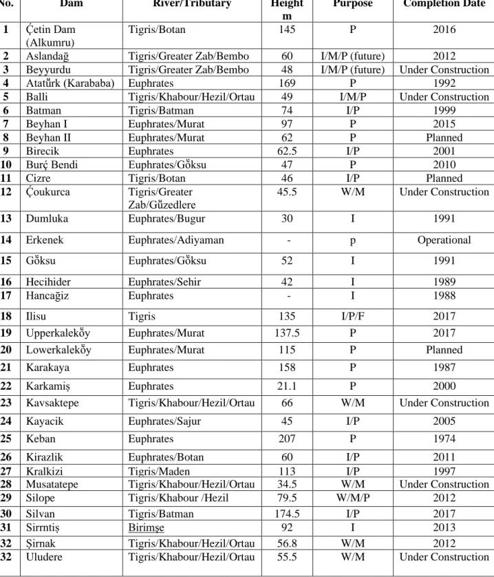
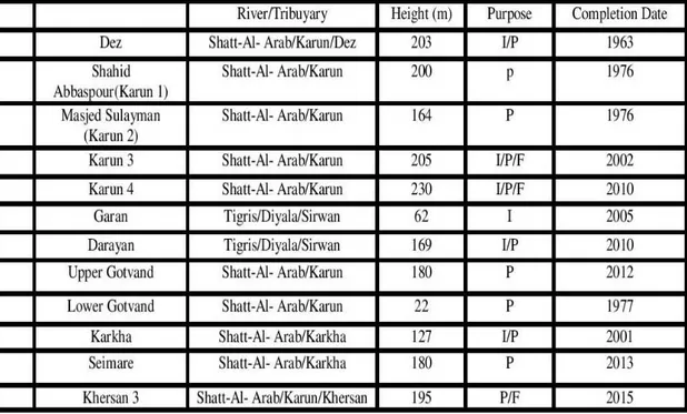
Keban Dam; the purpose of the Karakaya Dam is to produce hydropower also. The third dam on the Euphrates River, however, was the Ataturk Dam, which is the most important in the GAP Project and it was completed in 1992. It was designed to store water for large-scale irrigation as well as for the generation of hydropower [9]. The list in Table 3 shows the large dams in the Euphrates –Tigris River Basin in Turkey. These dams have total storage volume of around 100 billion m3. In this table the purposes for which the dams were constructed are denoted by symbols. The symbol P: denotes hydropower generation, I: means Irrigation use, W: is the symbol for water supply, mainly drinking water. The symbol M; however, denotes an unusual use of dams, i.e. military use, which in this case creating natural barriers that limit insurgents’ movements. The locations of these dams are in the rugged Zagros Mountains close to Turkey – Iraq borders and they have been the theatres of fighting between the Kurdistan Workers Party (PKK) militants and the government forces. The construction of most of these military dams was started in 2008, but some of them are not completed up to now due to fighting in the area [10]. This list contains only large dams according to the classification used by the International Congress of Large Dams (ICOLD), by either having height of 15 meters and more; or, having heights of (5-15) meters but at the same time their reservoir volumes are not less than 3 million m3. Table 4 lists the large dams on the two rivers and their tributaries in Iraq [11]. Figure 4 gives those dams constructed in Iran on rivers contributing to Iraqi water resources, namely Al-Karkha River, which feeds the south-eastern marshes and Karun River, which outfalls into the Shatt-Al Arab River.
Table 3: Turkish Dams on the Euphrates and Tigris and Their Tributaries
No. Dam River/Tributary Height
m
Purpose Completion Date
1 Ḉetin Dam
(Alkumru)
Tigris/Botan 145 P 2016
2 Aslandaḡ Tigris/Greater Zab/Bembo 60 I/M/P (future) 2012
3 Beyyurdu Tigris/Greater Zab/Bembo 48 I/M/P (future) Under Construction
4 Atatṻrk (Karababa) Euphrates 169 P 1992
5 Balli Tigris/Khabour/Hezil/Ortau 49 I/M/P Under Construction
6 Batman Tigris/Batman 74 I/P 1999
7 Beyhan I Euphrates/Murat 97 P 2015
8 Beyhan II Euphrates/Murat 62 P Planned
9 Birecik Euphrates 62.5 I/P 2001
10 Burḉ Bendi Euphrates/Gṏksu 47 P 2010
11 Cizre Tigris/Botan 46 I/P Planned
12 Ḉoukurca Tigris/Greater
Zab/Gṻzedlere 45.5 W/M Under Construction
13 Dumluka Euphrates/Bugur 30 I 1991
14 Erkenek Euphrates/Adiyaman - p Operational
15 Gṏksu Euphrates/Gṏksu 52 I 1991
16 Hecihider Euphrates/Sehir 42 I 1989
17 Hancaḡiz Euphrates - I 1988
18 Ilisu Tigris 135 I/P/F 2017
19 Upperkalekṏy Euphrates/Murat 137.5 P 2017
20 Lowerkalekṏy Euphrates/Murat 115 P Planned
21 Karakaya Euphrates 158 P 1987
22 Karkamiṣ Euphrates 21.1 P 2000
23 Kavsaktepe Tigris/Khabour/Hezil/Ortau 66 W/M Under Construction
24 Kayacik Euphrates/Sajur 45 I/P 2005
25 Keban Euphrates 207 P 1974
26 Kirazlik Euphrates/Botan 60 I/P 2011
27 Kralkizi Tigris/Maden 113 I/P 1997
28 Musatatepe Tigris/Khabour/Hezil/Ortau 34.5 W/M Under Construction
29 Silope Tigris/Khabour /Hezil 79.5 W/M/P 2012
30 Silvan Tigris/Batman 174.5 I/P 2017
31 Sirrntiṣ Birimşe 92 I 2013
32 Ṣirnak Tigris/Khabour/Hezil/Ortau 56.8 W/M 2012
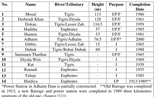
Table 4: Dams and Barrages in Iraq.
No. Name River/Tributary Height
(m)
Purpose Completion Date
1 Mosul Tigris 113 I/P/F 1986
2 Derbendi Khan Tigris/Diyala 128 I/P/F 1961
3 Dokan Tigris/Lesser Zab 116.5 I/P/F 1959
4 Haditha Euphrates 57 I/P/F 1985
5 Hamrin Tigris/Diyala 53 I/P/F 1981
6 Adhaim Tigris/Adhaim 76.5 I/P/F* 2000
7 Dibbis Tigris/Lesser Zab 15 I 1965
8 Duhuk Tigris/Rubar Duhuk 60 I 1988
9 Sammara-Tharthar Tigris - I/P/F 1965
10 Diyala Weir Tigris/Diyala - I 1969
11 Kut Tigris - I 1939
12 Ramadi Euphrates - I 1955
13 Faluja Euphrates - I 1985
14 Hindiya Euphrates - I/P 1913/1989**
*Power Station in Adhaim Dam is partially constructed. **Old Barrage was completed in 1913, a new Barrage and power station were completed in 1989 three kilometers upstream of the old one. (Source [11]).
Some Small dams were constructed by Iraq to relief the water stress situation in border areas with Iran. These are Al-Wand Dam in Khaniqeen town on the Wand River, The Mandli Dam on Glal Gangir River in Mandli, and Badra Dam on Galal Badra near Badra town. Many other dams were also planned for construction on the Tigris River system in Iraq. The construction of Badush Dam on The Tigris River 40 kilometers downstream of Mosul Dam was started in 1987, but it was abandoned at the end of 1990 due to the eruption of the first Gulf War and the economic sanctions imposed by the UN on Iraq, when 30% of it was completed. This dam was designed as a protection dam in the first place, as the integrity of Mosul Dam was (and still is) in question. The works were not resumed due to conflicting opinions on its value and to lack of funds. Works on Bekhma Dam, a very large dam on the Greater Zab, was started in 1989 but it was also stopped due to the same reasons. It may be worthwhile also to mention; that there are many other dams which have been designed and waiting construction. Examples are Mandawa Dam downstream of Bekhma Dam on the Greater Zab, Taq -Taq dam on the lesser Zab downstream of Dokan Dam and many other smaller dams in the Kurdistan Region on the Shamdenan and Haji Beg; tributaries of the Greater Zab, in addition to Guma Span Dam on Wadi Bastoura, which is a seasonal wadi out flowing into the Grater Zab to the north west of Erbil, and Bassira Dam south of Sulaimania on Qader Karam River which is a tributary to al-Adhaim River. Many small dams are also constructed or planned for construction on Wadi Hauran, which is a seasonal wadi
which drains an extensive area in the western desert and extends in Saudi Arabia, and outflows in the Euphrates River downstream of Baghdadi village.
Engineering works on the Karkha and Karun rivers in Iran have already caused considerable changes on the aqueous environment in the south of Iraq by limiting fresh water supplies to the marshes causing shrinkage of these water bodies and increasing the salinity. Figure 4 lists those dams on those two rivers and on Sirwan River; A tributary to the Diyala River. In addition, Iran also constructed during the sixties of the last century diversion works on Al-Wand River, another Diyala River tributary which resulted in a severe water stress in and around Khaniqeen town in Iraq. Another 114 m high dam for diversion purposes on the Lesser Zab River has just been commissioned and it is causing already big problem for drinking water supply to Qalaa- Dez district in Kurdistan-Iraq. Moreover, Iran is going ahead at fast rate in the construction of the Darayan dam shown in Figure 4 and a 47km tunnel which associated with to divert most of the Sirwan River water to irrigate the arable land in Kermanshah area in western Iran; and by doing so depriving Halabja area, Said Sadiq and Shaherzur lands in Kurdistan-Iraq from irrigation water and drinking water supply.
When looking at the extensive use of the Euphrates and Tigris rivers water resources by the three countries; Turkey, Syria and Iraq it is very clear that the three countries have planned and implemented big development projects with very little effort made to coordinate these schemes. They have, for example, developed very large water storage capacities, which have only pushed for the individual accumulation of water rather than adopting an attitude for optimizing this sharing. This also raises the question whether the actual volume of these resources is enough to fill all the implemented storages, or if there will be enough water to supply all the irrigation schemes already completed. The natural consequence to these inefficient policies is to result in ineffective and inefficient demand/supply management practices and may be considered as one of the main factors influencing the water imbalance in the region. This issue can well be the reason for increased tension in the region in the future unless more cooperative policies are adopted by the countries in question to follow optimization and increased efficiency procedures.
3. Tigris and Euphrates Dams: Impacts on water sharing,
river dynamics and ecosystems
3.1 General
Generally, large dams impact rivers unlike any other freshwater developments. They change the most important characteristic of rivers: their flow; quantitatively, temporally and, moreover qualitatively. In total, they result in diverse changes in the ecosystem of the basins to which they belong. These changes can be classified according to whether they are; first order impacts that involve the physical, chemical, and geomorphologic consequences of blocking a river and altering the natural distribution and timing of stream flow. Second-order impacts that involve changes in primary biological productivity of ecosystems; including effects on riverine and riparian plant-life and on downstream habitat, such as agricultural lands and wetlands; or Third-order impacts that involve alterations to fish life.
The construction of a storage dam and subsequent inundation of the reservoir area effectively result in loss of vegetative cover in the watershed area and lead to increase in erosion and accumulation of sediments in the reservoir itself, and it will initiate at the same time the degradation of the river course immediately downstream. In reducing flood volumes and their frequencies by flood protection dams, this results in, silting up of the rivers concerned, change meandering patterns
and sediment accumulations in further reaches and in canals intakes. The reduction in sediments and nutrient transported in rivers immediately downstream of dams has impacts on the flood plain and coastal delta morphology and causes the loss of aquatic habitat of fish and other species. Large dams can also result in raising tensions between communities in the same country or between riparian countries; when developments go on without previous agreement or cooperation. Some of the negative impacts on the Tigris – Euphrates rivers Basin ecosystem due to the construction of dams are given by the [13], which include among other things the following potential impacts; Biodiversity loss (wildlife, agro-diversity), desertification/drought, deforestation and loss of vegetation cover, large-scale disturbance of hydro and geological systems, and reduced ecological / hydrological connectivity. Another important impact, which is not mentioned but implied, is the adverse consequences on human habitat in the basin resulting from reduced flows to the downstream countries.
3.2 Water availability to the riparian countries
Extensive exploitation and development of the Tigris – Euphrates rivers water resources ensued in the seventies of the last century and have continued up to date. The intensive activity in dam building and development of irrigation projects in the riparian countries had aimed at fruitful results on agricultural outputs and power generation. The benefits; however, were not equitably shared by these countries, but go rather in a descending order; Turkey, having the highest share, followed by Syria and then Iraq at the end of the scale. The negative outcomes of such uses impacted these countries in a reverse order. This was manifested in Syria and Iraq by reduced flows in the two rivers, leading to increasing tensions between all these countries; and to increased salinity of the river waters and increased salinization of the agricultural lands, especially in Iraq where the salinity had been already an acute problem, while Turkey itself did not escape the salinity problem also .
The South Eastern Anatolia Project, “Güneydoðu Anadolu Project”, (GAP) project in Turkey, which triggered these problems is intended to extend irrigated agriculture, and when completed, it will cover an area of 7,500,000ha, and will have 22 dams and 19 power plants [14], Figure 5 [15]. Turkey now is going ahead with the GAP project development as central element in its future economic plans. Both Syria and Iraq are having deep fear that this project will result in serious downstream impacts, including reduced flow and increased levels of pollution to unbearable limits. The newly irrigated land would increase the area in Turkey under irrigation by 40%, but at the same time will consume unfair share of the Tigris and Euphrates waters. Projects on the Tigris River only are scheduled to irrigate a total of 601,824 hectares. On the basis of the figures published by the GAP authorities, Iraq calculates that the irrigation projects on the Tigris within the GAP will consume 5.8BCM and reduce the flow of the Tigris River as it passes the border into Syria at Cizre by 66% from an annual discharge of annual 16.72BCM to 5.68BCM Iraq estimates that it would receive 48% of the water it receives at present. According to
the Iraqi authorities; such a big shortage in the Tigris River resources will result in grave repercussions on Iraq. A large portion of Iraq's population depends on the Tigris River to meet their drinking water needs, agricultural requirements and other domestic needs. Agriculture has been practiced for thousands of years along the said river and technical studies have shown that a decrease of 1Bm3 in the river's resources will result in the abandonment of arable lands estimated at 62,500 hectares (ha). Since the current river's resources suggest a drop of 11.04Bm3, the total agricultural area, which will be deprived of water in the Tigris basin within Iraq will reach 690,000 ha. The non-use of such areas will have severe consequences for the entire agricultural production and the water supply for existing farms, as well as other social and economic impacts on farmers deprived of agricultural requirements, let alone the problem of desertification, which will be exacerbated as a result of the above-mentioned reduction of arable lands.
Figure 5: Map of Irrigated Land in GAP Project (within red boundary) (
[15]
).Syria, which has a similar dependency on the flow of the Euphrates River, forecasts similar problems arising from reduced flow of that river. Before the construction of the Keban Dam in 1966, Turkey used just 3% of the waters of the Euphrates River for irrigation. When the GAP is completed, the total irrigated area for the Euphrates and Tigris Rivers’ basins in Turkey will increase to 1,628,203 hectares, requiring (9 -16.9) Bm3 of water per year. Syrian officials estimate that the downstream flow
of the Euphrates River as it crosses the Syrian border will be reduced by (30 – 60%). Infect, Turkey is planning to use completely half of the Euphrates yield, leaving
Syria and Iraq with the other half. Moreover, 11% of this half will be water of lower quality since it is returned irrigation water from irrigated lands in Turkey.
3.3 Salinity and Salinization
Increased salinity in the water of the Tigris and Euphrates Rivers and salinization of agricultural land has already begun to show their effects in both rivers’ basins. According to [16], the GAP region itself is also suffering now from salinity problems caused by irrigation. The region is situated in arid and semi-arid zones of Turkey. After the irrigation systems became operational, salinity and sodicity problems along with drainage problems increased. Salinity and drainage problems related to GAP present now more priority than irrigation. The Harran Plain, which is irrigated by the Atatürk Dam, faces excessive salinization as a result of the rising level of groundwater. The level of salinization in the area in 1987 was 5,500 hectares; in 1997 it stood at 7,498 hectares and in 2000 it had expanded to 11,403 hectares. As a result, there have been high levels of aquifer and groundwater contamination. Additionally, wells equipment has been corroded due to salty water [17].
Similar problems are facing Syria in its irrigated lands. One report [18]) concluded: “In Syria in 1989, 6000 ha of irrigated land were estimated to be affected by salinization; some 5000 ha in the Euphrates basin have been abandoned due to water logging and salinity problems”. One would expect that this affected area has increased many folds over since 1989 after the operation of more dams and extending irrigated lands further in Turkey and Syria itself due to the application of inefficient irrigation methods, and the absence of proper drainage. Unfortunately, updated verified statistics are not available on the situation now. This increase may be attributed to increased salinity in the Euphrates River water resulting from saline return flows from the GAP irrigation projects, together with the use of inefficient methods of irrigation as already stated. Still, inefficiency is not the only problem with improper irrigation but excessive irrigation of heavy clayey soils can cause the groundwater level to rise (so-called ‘water logging’), which draws salt naturally stored in the ground to the surface by capillary action, thereby causing salinization of the top soil layers forming what is known locally in Iraq by “Sabkha”. This salt is then flushed out and transported back into the freshwater systems by irrigation return flow [19]. At the Euphrates River basin in Iraq; salinization is already a severe problem. While the salinity of the river’s headwaters in Turkey is quite low with about 260 parts per million (ppm), it rises substantially to 1,040 ppm at the Syrian–Turkish border and peaks at about 4,000 ppm at Nassiriah, Iraq. These values are extremely alarming. According to World Health Organization standards; water with salinity exceeding 1,000 ppm is unfit for human consumption, [20], and where the total dissolved salts (TDS) rises above 2,000 ppm, it cannot be utilized for crop irrigation [21].
The Tigris River, so far, is much less affected by salinization than the Euphrates River. Its headwaters have salinity of 275 ppm, and at present there is no rise in the
Tigris’ salinity upstream from where it enters Iraq; but, it is expected that, once the GAP Tigris developments are fully operational, especially when Ilisu Dam and its irrigation projects are completed, they will cause the Tigris’ salinity to rise to 550ppm where it enters Iraq. As of now, the river’s salinity is about 1,000ppm at Baghdad, stays on this level until Kut; 200km downstream of Baghdad, and peaks
at 2,250ppm; 150km further downstream at Ali Al-Sharki in Ammarah Governorate. The impacts on agricultural productivity in the Euphrates basin in Iraq due to
increased salinity levels in the Euphrates water will be devastating. Taking both Tigris and Euphrates basins together; it is estimated that some 1.3 million hectares of rich agricultural land (some 40% of the area in Iraq that is suitable for cultivation) could be lost for production [22].
Significant impacts on Iraq’s fresh water have also resulted from water diversions due to dams in Iran, more specifically, the Karkha River Dams and the Karun River Dams and their related agricultural projects. The Karkha used to be the main supplier of fresh water to the Hur Al-Haweizeh marsh, which suffers now from reduced quantities of water coupled with increased salinity as a result of the expansion of agricultural lands and urbanization in the basin. The marsh surface area has decreased from (300,000 – 500,000) ha to only 137,000ha, and water quality data from 1988 and 2002 show significant increases in salinity. For instance, while the EC value at Hamidiyeh was around 600 µS/cm which is equal to TDS of 384ppm in 1988, it had increased to 2,500µS/cm (TDS= 1700ppm) by 2002. Rapid agricultural and urban development over recent decades has led to an increase in irrigation return flows, as well as a rise in domestic and urban sewage discharge in the river. The 1999/2000 drought and the resulting decline in river discharge are considered additional important factors in reducing Karkha River water quality. Iraq has voiced concern over recent Iranian plans to construct a levy along the Iran-Iraq border through the Haweizeh marsh. Such a levy would reduce freshwater flow to Iraq, further threatening the marsh ecosystems to dangerous limits [23].
The Karun River is severely impacted by pollution from agricultural, industrial and domestic sources, which increases along the river course. Agriculture and industries are the main polluters, a large proportion of the irrigation water is returned to the Karun River through agricultural and agro-industrial drainage. As a result, the water quality of the Karun River is rapidly deteriorating and rising salinity and other pollutants are a key concern. In 2001, an average EC value of 533µS/cm (TDA= 341ppm) was observed in the basin’s headwaters (Dez Dam). However, at the river’s confluence with the Shatt al Arab at the city of Khorramshahr, the average salinity was almost seven times higher in the same year, and almost three times higher than in the 1970s. Apart from salinity issues, high concentrations of three heavy metals (Cr, Ni, and Cu) were observed in the downstream part of the Karun River as a result of human activities. The various sources of pollution have endangered aquatic life in the basin and rendered Shatt Al-Arab water unusable for both human consumption and Irrigation.
3.4 Impacts on the Ecosystem
Dams and manmade diversions profoundly affected the quality of waters throughout the river system. Water emerging from a dam is not the same as water entering a reservoir. Discharge from a dam may create significant temperature changes, sediment load variations, dissolved salt load, organic content. Changing the volume and the stream flow regime of the river remains however, the most significant effect induced by dams. All these conditions have the potential to affect the environmental quality and condition of the Tigris Euphrates Rivers’ system in Turkey, as well as the downstream water systems in Syria and Iraq. The development of GAP dams and, the other dams in Syria, Iran and Iraq have had significant impacts on river morphology and ecosystems along the respective reaches of the two rivers. Diversion systems from these dams have also produced more changes.
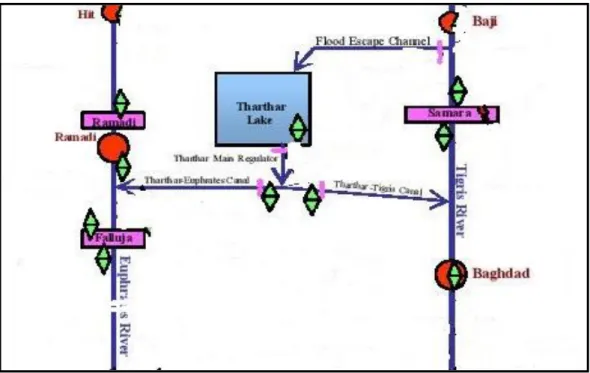
One of the important diversion systems on the Tigris River is the Samarra – Tharthar complex. This project was implemented in 1956 and it was intended originally as a flood protection scheme to save Baghdad from the destructive floods of the Tigris River, which had destroyed the city many times over history [24, 25]. The scheme consists of the Samarra barrage, which diverts high flood flows from the Tigris River at Samarra to the Tharthar flood escape channel through the Tharthar head regulator and then passed to the Tharthar depression creating the enormous Tharthar Lake Reservoir and. At the same time, only manageable flows are released through Samarra Barrage itself to Baghdad. The Tharthar lake was used later on to augment the Euphrates and Tigris flows in low flow periods by returning water to the Euphrates River by a large canal; which after 28km splits into two branches; the first branch takes water to the Euphrates River and it is called (Dhiraa El-Furat), while the other branch transfers water to the Tigris River at a location just north of Baghdad at Taje, and it is called (Dhiraa Dijla). The schematic diagram in (Figure 6) illustrates this scheme.
The operation of this system faced by many difficulties. The first was the high salinity of the lake water; the Tharthar depression was formed during the Holocene age by karstification as a result of dissolution of gypsum rock [26], and therefore, the water of the created lake had very high initial concentration of sulphate that was made worse by evaporation of water from the lake surface. The released water to the two rivers was continuously regulated so not to cause adverse salinization effects in them and trying at the same time to desalinize the lake’s water by the delusion with the Tigris River water diverted by Samarra Barrage. The management process proved to be very difficult and it was not always free from undesirable consequences on the water quality of the two rivers. The continuous diversion of high floods to the Tharthar Lake by the Samarra barrage resulted over the years in changing the regime of the Tigris River at the lower reach dofigurwnstream of the barrage and caused heavy siltation of its channel in Baghdad, Normally the river’s channel was previously flushed by these floods almost every year. Consequently, the ability of the river to pass high floods was reduced. This has led to the increase of flooding potential for parts of the city. The problem now has taken such a big
dimension that dredging operations have to continue all the time.
Figure 6: Schematic diagram illustrates The Samarra-Tharthar Scheme. Similar siltation problems are experienced in the head reaches of Samarra barrage itself and Kut barrage where dredging works are mostly needed. The situation upstream Diyala weir on the Diyala River is not less serious which have resulted from the Derbendikhan and Hamrin Dams operation. This heavy siltation threatens the normal supply of water to the head regulator of the vast Diyala Irrigation System.
3.5 Impacts of Uncoordinated Planning and Operation of Fresh Water Resources Developments
Any river basin may be considered as the geographical area within a drainage divide in which that river flows. River basin’s natural boundaries always follow the highest ridges/ and or elevated areas around the river channel and meet at the lowest point of the land where water flows out of the basin. In international rivers shared by two or more countries, a river basin boundary may not, in most cases, coincide with the national boundaries of these countries which may lead to possible conflicts unless the riparian countries agree on some sharing policy. Ideally, development projects within a riparian basin can maximize total benefits and minimize negative impacts on the individual countries within the basin if total agreement can be reached between these countries on the utilization of the Trans-Boundary River or rivers involved. This, unfortunately has not been the case in many international river basins in the world including the Tigris and Euphrates Basins.
In addition to political tensions and rivalries, the development of shared water resources in a river basin carried out individually by riparian countries, may prove very difficult, uneconomical and charged with adverse effects on the environment inflicted by the upper reaches in the river basin on the lower reach on the same river. The Tigris and Euphrates rivers’ basins are not any exception. Although Iraq started to develop its dams and irrigation system well ahead of Syria, Turkey and Iran, the later developments in those countries resulted in reducing the water available to Iraq and lowering water quality available for its uses as explained in subchapter 6.6.3, in addition, rendering Iraq’s dams planned capacities oversized and partially redundant. A good example is the implementation of Ilisu Dam on the Tigris River in Turkey which is nearing completion now; this dam will affect the operation of Mosul Dam (completed by Iraq in 1985) considerably. When Ilisu Dam operation is starting in 2017 the regulation of flood flows of the Tigris River presently done by the Mosul Dam will be taken up by the Ilisu Dam and Mosul Dam becomes partially obsolete and oversized, as the Mosul Reservoir may be partially filled [27]. Iraq, predicts that the reduced flow will be reflected badly on the power generation from Mosul Dam and Samarra Barrage. It is expected that the power production in Mosul Dam will drop at a rate close to that of water reduction in the discharges coming to the dam: that is to say, approximately 53%. [22]. Similar impacts must have been expected on the Tabqa Dam as direct result from the construction of large dams implemented by Turkey on the Euphrates River at later dates.
Another example of a similar case, but involving Iran this time, may be taken from the Daryan Dam on Sirwan River, which is located in Kermanshah Province just 28km from the Iraqi – Iranian borders. The river itself is considered as the major contributor to the Diyala River water resources (see Figure 4). This high dam is built to generate 230MW of electric power, but the 47-kilometre-long water tunnel associated with this dam, called the Nawsud water tunnel is due for completion in 2018 and it will divert on completion water to the south western region of Iran to irrigate arable land. This in effect will deprive 3200ha of arable land in Halabja, Sayid Sadik and Derbendikhan from their supply. Moreover, it will endanger the newly constructed $173 million scheme for drinking water supply of Halabja-Sirwan and, the Derbendikhan Dam will no longer be of use for providing hydroelectric power and irrigation water, since it draws 75% of its water from the Sirwan River [28].
If joint planning had been done in the implementation of all the conflicting projects in the basin of the Euphrates and Tigris Rivers, being agricultural or for power generation, the level of damage to the riparian countries in the lower reaches could have been reduced and large saving of expenditures could have been done. Such cooperation between the riparian countries one could argue is not possible; unless there is exchange of benefits in other fields. Fruitful discussions may lead to signing of treaties between these countries, which cover wide spectrum of economic cooperation and with water resources being one issue.
4. Geopolitics of Sharing Water Resources of the Tigris and
Euphrates Rivers
4.1 Historic Overview
The entire basin of the Euphrates River and most of the basin of the Tigris River became part of the Ottoman Empire early in the sixteenth century and remained under Ottoman rule until 1918. During this time, there could be no international disputes over the Euphrates River, and, given the modest scale of usage, there appear to have been few or no international disputes between the Ottoman and Persian Empires (modern Turkey and Iran) regarding the use of the Tigris River [29]. Many treaties that attempted to define the boundaries were concluded between the Ottomans and the Persians during the nineteenth century and the first two decades of the twentieth century, such as the two treaties of Erzurum of 1823 and 1847, and the 1913 Protocol of Constantinople. These treaties were dealing with a boundary line in the Shatt Al-Arab itself, and none of them was concerned with consumptive uses of water. After the Allies' victory over the Ottoman Empire in 1918, the region was partitioned between a British Mandate over Iraq, a French Mandate over Syria, and a residual portion was left to Turkey. This was the origin of the present state structure in the basin.
During the mandate period, questions related to water issues were resolved by an established joint committee. One accord was signed in 1921 between France and Turkey related to sharing the water of some small stream originating in Turkey and passing into Syria, and also authorized the city of Aleppo to water supply from the Euphrates River. Another general agreement was signed in 1926. Similarly, the declaration was also made by the commission on the delineation of Syrian-Turkish borders, which proclaimed that all issues related to the water use of the Tigris River were to be settled on the basis of complete equality. As for the question of sharing the Euphrates River; Britain, France, and Turkey did not have any dispute, and this continued even after Syria and Iraq gained complete sovereignty. The three independent states were not sufficiently competitive over water rights to warrant a new agreement. Moreover, Turkey and Iraq under the British mandate; in 1930 agreed that no change of the flow of the Euphrates River would be made without the mutual consent of the two countries. Further to that, they both agreed in 1946 that Turkey would not alter the Euphrates flow without informing Iraq, and, to adapt any future works to the needs of both states “as much as possible”. It also allowed Iraq to construct protection and observation posts in Turkey’s territory to prevent downriver flooding and, thus, benefit Iraq [30]. Arguably, the effect of these treaties was Turkish acceptance of Iraq's vested right to receive its then established uses of about 13BCM. In later years the construction of the allowed posts was not implemented by Iraq and these agreements were shelved. Moreover, a meeting in 1965 of the representatives of the three states saw to the demise and end of the treaty system [31].
As demand for water exceeded supply, the national water authorities attempted to engage in dialogue and set up ad hoc and provisional committees for negotiations
[32]. In the 1960’s, the three riparian states entered a new phase of their relationship over water, upon Turkey’s decision to construct the Keban Dam on the Euphrates River. The downstream riparian states, particularly Iraq, insisted on guaranteed flows 350m3/s as minimum to be released by Turkey during the impounding period. Hence, a first meeting was held in June 1964 with the attendance of Turkish and Iraqi experts. At the end of the negotiations, Turkey guaranteed to undertake necessary measures to maintain a discharge of 350m3/sec immediately downstream from the dam, provided that the natural flow of the river was adequate to supply this discharge. Turkey also proposed the establishment of a Joint Technical Committee (JTC), which would inspect each river to determine its average yearly discharge. The JTC would determine the irrigation needs of the three countries through joint field studies and would be authorized – by calculating the needs of the riparian states for present and future projects – to prepare a statement of the main principles and procedures in order to facilitate an agreement on water rights [33]. Subsequently, as Syria was proceeding with the construction of Al Tabqa Dam, Syria and Iraq held several bilateral meetings on technical matters concerning the distribution of Euphrates River waters. Syria strongly opposed Iraq’s position of having “established water rights” during the negotiations and continued with the construction of the dam. However, reportedly Syria informally accepted that Iraq was entitled to 59% of Euphrates River water flow in normal years.
Throughout the 1970’s, 1980’s and 1990’s number of crises occurred in the region, following the unilateral development of several water resource projects. Turkey started impounding the Keban reservoir in February 1974 at the same time as Syria had almost finalised construction of the Tabqa Dam. The impounding of both reservoirs in the following two years escalated into a crisis in 1975 with Iraq accusing Syria of reducing the river’s flow to intolerably low levels, while Syria blamed Turkey. The Iraqi government was not satisfied with the Syrian response and mounting frustration resulted in mutual threats of armed conflict. This was averted when Saud Arabia mediated and ensured that extra water was released from Syria to Iraq. Later on, and addressing the Ataturk Dam question a protocol between Syria and Turkey was signed in 1987; the protocol was developed by the Turkish-Syrian Joint Economic Commission on July 17, 1987, and at the time was considered provisional [34]. The text of Article 6 of the protocol reads as follows: “During the filling up period of the Atatürk Dam reservoir and until the final allocation of the waters of Euphrates among the three riparian countries, the Turkish side undertakes to release a yearly average of more than 500m3/sec at the Turkish-Syrian borders and in cases when monthly flow falls below the level of 500m3/sec, the Turkish side agrees to make up the difference during the following month”. The impounding of the Atatürk Dam created flow issues on the Euphrates River and required water allocation agreement between the three riparian countries. A bilateral accord between the Syria and Iraq was developed, according to which 58% of the Euphrates River water coming from Turkey would be released to Iraq by Syria. [35]. Another major crisis occurred; however, in the early 1990’s. The filling of the Ataturk Dam in Turkey was started on 13 January 1990.Turkey temporarily reduced
the flow of the Euphrates River in order to fill the Ataturk reservoir (January was chosen because it was the month with no demand for irrigation water). Turkey notified its downstream neighbors before November 1989 of its intention and in a communication; it explained the technical reasons behind the action and also provided a detailed program for the replenishment of the losses. Turkey also released twice the usual amount of water for two months prior to terminating the flow and sent delegations to the region to explain the need for the action, and the measures taken. The work was finished in three weeks, as opposed to the one month initially planned. However, Syrian and Iraqi governments still registered official complaints, and consequently called again for an agreement to share the waters of the Euphrates River. Finally, in 1996, the construction of the Birecik Dam in Turkey was accompanied by strong protests on the sides of Iraq and Syria, which led to another crisis [33]. As a consequence, Iraq and Syria allied and, apparently organized a joint water coordination committee. The parties conferred on possibilities of an equitable and reasonable sharing and utilization of the Euphrates and Tigris Rivers’ waters. In the meetings, Syria and Iraq decided to coordinate their positions on the water dispute. In May of the same year, Turkey called on Syria to engage in talks over water. Turkey wanted to resolve the dispute by dividing water by cultivated land, whereas Syria wanted to divide the water equally [36], so no agreement was reached.
In 2001 relations between Turkey and Syria improved considerably and an agreement was signed between them which aimed at (further) improving the relations, fostering dialogue and creating cooperation mechanisms between the two countries in various fields. The agreement stipulated technical cooperation on many issues and levels including the water question. According to later reports, there were some activities in the field of cooperation on water issues. In 2007, Turkey and Syria decided to re-activate the JTC and held a series of meetings. They agreed to share information on meteorological patterns and water quality. This was followed in 2009 by many Memoranda of Understandings (MoUs) signed between the two riparian states.
Similarly, Turkey and Iraq agreed to cooperate in various fields, such as politics, economy, energy, culture, security as well as in water sector and signed many MoUs to these effects. The agreement on water issues was concerned with the exchange of data, information and expert knowledge, the efficient use of water resources and the strengthening of the JTC. In the same cooperative attitude, Turkey and Syria enhanced their cooperation by signing more agreements and MoUs; four of which are noted to concern water questions [33].
Finally, some sources refer to a tripartite MoU from 2009. However, there is a little or no information to be found on this tripartite MoU of 2009 as well as the three-launched JTC. On the other side of the Euphrates- Tigris Rivers’ Basins, where Iran plays a significant role, and, especially in dealing with Shatt Al-Arab question, independent Iraq and Iran signed many agreements following the 1913 Constantinople accord, which were only concerned with the border’s delineation between the two countries. This chronic issue was a result of the continuous shifting
of the river watercourse. The next agreement was that of 1937; signed with support from the League of Nations. The agreement gave full sovereignty over the two banks of the river to Iraq, which only stirred later on tensions between the two states as Iran kept claiming half of the river to its sovereignty. In the early 1970’s strong pressure was exerted from Iran on Iraq by supporting the Kurdish rebels in north of Iraq as a way to force Iraq to negotiate the Shatt Al-Arab status. An agreement was signed in 1975 with the mediation of Algiers. The agreement ended the Kurdish rebellion and forced Iraq to concede its right in half the Shatt Al-Arab [37]. The agreement was considered by Iraq as humiliating one, which added further strains to the bilateral relations and contributed among other issues to the first Gulf war (1980 – 1988) [38]. At the end of this bloody war, both parties accepted a cease fire brokered by the UN, but this did not succeed in settling the Shatt Al-Arab dispute [39]. And, although Saddam Husain’s regime was overthrown in 2003 by the occupation of Iraq, successive Iraqi governments kept the strong position that Iraq would never reinstate the 1975 agreement.
In recent years, relations between Iraq and Iran have improved considerably, which was reflected on the Shatt Al-Arab issue. In 2014, the Foreign Ministers of the two countries met and discussed among other things the Shatt Al-Arab issue. The two sides reached understandings on how to move forward and implement agreements in accordance with the border’s treaty, protocols and agreements signed between the two countries in 1975. They also agreed on resuming work on the marking of land borders, the common boundary rivers and sharing of their water [40]. This perspective of cooperation is very timely, as reports point out the increasing deterioration of water quality and its hazardous threats to health and agriculture in the Shatt Al- Arab region, in addition to the continuous construction of dams and water withdrawal from the tributaries of the Tigris River, which was started in the 1960’s and is continuing to date. This issue has caused considerable hardship to the Iraqi population in general and to the inhabitants of border areas in particular; such as Khanqeen, Mandli, Badra and Jassan and lately to Qalaa-Diza, Halabja, and Shir-Zur in Iraqi Kurdistan Region.
To sum up, several formal and informal agreements were concluded after World War II between the Riparian States of the Tigris-Euphrates Rivers’ basins. None of these; however, addresses the question of the equitable water utilization and management of either the Euphrates or the Tigris Rivers comprehensively. Further work still waits all the Riparian States (Turkey, Syria, Iraq, and Iran) in this field for better prospects in the future.
4.2 International Law and Water Sharing Issues between the Tigris-Euphrates River Riparian States
The conflict over freshwater resources of the Euphrates River, and to a lesser extent the Tigris River has taken many decades of arguments and discussions between the three Riparian States, Turkey, Syria, and Iraq. The three countries have had justifications to their claims from the provisions of the International Water Laws, various theories, and accepted principals. These doctrines were the basis of the International Water Law, the Helsinki Rules [41], Berlin Rules [42] and the UN convention on the law of the None Navigational uses of International Water Courses [43]. Among the most important provisions of this legal framework are; First: the doctrine of equitable utilization implying fairness and reasonable use. Second: is the rule of causing no harm. Both provisions originate from the theory of limited territorial sovereignty, which restricts territorial sovereignty of any Riparian State to the part of an international fresh water system that is located on its territory, and the Riparian State has to respect the right of the other riparian States to utilize the system. Another approach to the problem of fresh water sharing is the theory of community interest, which is based also on the theory of limited sovereignty to reflect the interdependent character of freshwater systems. It considers any international freshwater systems as one legal entity; regardless of state borders. So, the collective use of all riparian states must pursue the sustainable development of the natural water resources. The riparian states should; therefore, recognize the limitation imposed by the hydrological cycle, which would require that the planned amount of water withdrawal from freshwater system does not exceed the amount it receives through the hydrological cycle and, that its water is not polluted to the
extent that it cannot be regenerated by the hydrological cycle [44]. In the long debate and negotiations of water sharing, each of Turkey, Syria, and Iraq
has supported their claims and counter claims by the various clauses of these International stipulations. Syria and Iraq argue that Turkey has more fresh water than she possibly can use. Turkey; however, claims that this is not true by stating that out of 180BCM of the annual runoff; 110BCM is usable and only 25.9BMC actually can be made available due to technological, topographical and geological reasons; therefore, these resources are not always available for use at the right time and the right place [45, 46, 47].
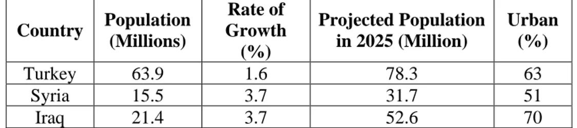
According to the last FAO estimates [48], the present per capita withdrawals of fresh water measured in m3/per capita/ year in the three riparian countries stands at; Iraq (2,525), Syria (817.4) and Turkey (549.3). The figures were obtained for Iraq in 2002, and in 2007 for both Syria and Turkey. These withdrawals are expected to be modified drastically due to increased use of water in Turkey due to the GAP project and also as expected from the negative impacts of the Global Climate Change, and the population growth. The expected population growth in these countries up to 2025 is given in Table 5 [49]. According to these data, the annual per capita share of water will be reduced considerably.
Table 5: Population characteristics within Tigris-Euphrates Rivers’ Basins Urban (%) Projected Population in 2025 (Million) Rate of Growth (%) Population (Millions) Country 63 78.3 1.6 63.9 Turkey 51 31.7 3.7 15.5 Syria 70 52.6 3.7 21.4 Iraq
The other issue of conflict between Syria and Iraq on one side and Turkey on the other is the claim fostered by Iraq and Syria of having historic acquired rights based on their use of the Euphrates River waters from ancient times. Turkey, however, does not recognize such rights on the basis that any acquired water right can only be considered if it is based on equitable use as defined by Helsinki rules; Articles I and V [41], which account for socioeconomic, geopolitical and hydrological factors, in addition to the avoidance of unnecessary waste in the utilization of waters of the basin. Turkey, in this matter accuses both Syria and Iraq of wasting their water resources by using old practices and wasteful water management procedures. In fact, Turkey had advanced in the technical talks with the other riparian states in 1984, a three stage plan [34] to deal with equitable sharing and this was reiterated in the following talks. It stipulated that allocations should be done in the following stages. First; assessing the available resources, Second; carrying out inventory studies of available land resources; Finally, only after the modernization and rehabilitation of on-going projects and improving irrigation practices to determine their economic viability, then the total water consumption and demand can be calculated, and then rational and equitable allocation of water shares to the three countries can be reached. This action plan is based on two premises. The first one considers that the Tigris and Euphrates Rivers as one transboundary water course and, the second is that actual requirements of any of the three countries should be based on scientific studies of the needs of that country.
This plan was rejected by Iraq and Syria as being vague and works to Turkey’s advantage and that it fringes on the sovereignty of the riparian states. Additionally, Iraq on his side does not accept the one basin concept on which this plan rests on the ground that the Tigris and Euphrates Rivers’ basins are geographically separate basin. Turkey however, in forwarding the one basin solution had argued that Iraq can augment the deficiency in the Euphrates River’s waters by transferring water from the Tigris River basin through the Tharthar channels, which is actually being done at the moment. This argument; however, is losing its basis at the moment as the Tigris River’s basin itself will face water stress after the operation of Ilisu Dam. Another matter of conflict between the three riparian countries is the application of the “causing no harm” doctrine defined in article X of the Helsinki Rules [41], and article 16 of the Berlin Rules [42] in addition to article 7 of Part II of the UN convention on the law of the None Navigational uses of International Water Courses [43]. This doctrine, which embodies the Latin doctrine translated, “so use your own
![Figure 2: Photograph of the remains of Al-Nahrawan canal near Ba’quba taken by Gertrud Bell ([4])](https://thumb-eu.123doks.com/thumbv2/5dokorg/4426701.106492/5.813.222.629.107.423/figure-photograph-remains-nahrawan-canal-taken-gertrud-bell.webp)
![Figure 5: Map of Irrigated Land in GAP Project (within red boundary) ( [15] ).](https://thumb-eu.123doks.com/thumbv2/5dokorg/4426701.106492/16.813.161.656.418.734/figure-map-irrigated-land-gap-project-red-boundary.webp)