Transbasin Water Transfers
Proceedings of the
2001 USCID Water Management Conference
Denver. Colorado
June 27-30, 2001
Sponsored by
U.S. Committee on Irrigation and Drainage
Edited by Jerry Schaack
Garrison Diversion Conservancy District Susan S. Anderson
U. S. Committee on Irrigation and Drainage
Published by
U.S. Committee on Irrigation and Drainage 1616 Seventeenth Street, Suite 483
Denver, CO 80202 Telephone: 303-628-5430
Fax: 303-628-5431 E-mail: stephens@uscid.org Internet: www.uscid.org/-uscid
USCID
Tile Mission oJthe United States Committee on Irrigation and Drainage is to Joster sustainable, socially acceptable and environmentally responsible irrigation, drainage and flood control systems and pract;ce.~ Jar providing food, clothing and shelter to the people oJthe United States and the World.
USCID is a nonprofit professional society whose members share an interest in the planning, design, construction, operation and maintenance of irrigation, drainage and Hood control works; agricultural economics; water law; and environmental and social issues affecting irrigated agriculture.
USCID published the USCID Newsletter, proceedings of USCID meetings, and special reports; organizes and sponsors periodic technical meetings and conferences; and distributes publications of the International Commission on Irrigation and Drainage. lelD publications include the ICID Journal, Irrigation and Drainage in the World, and the Multilingual Technical Dictionary on Irrigation and Drainage.
For additional information about USCID, its publications and membership, contact:
U.S. Committee on Irrigation and Drainage 1616 Seventeenth Street, Suite 483
Denver, CO 80202
Telephone: 303·628·5430 Fax: 303·628·5431 E·mail: stephens@uscid.org Internet: www.uscid.org/-uscid
The U.S. Committee on Irrigation and Drainage accepts no responsibility for the statements made or the opinions
expressed in this publication.
Copyright ,~ 200 I, U.S. Committee on Irrigation and Drainage Printed in the United States of America
Library of Congress Control Number 200 I 091962 ISBN 1·887903·12·7
-/
Preface
These Proceedings include the papers presented during Transbasin Water Transfers, a Water Management Conference sponsored by the U.S. Committee on Irrigation and Drainage. The Conference, held June 27-30, 200 I, in Denver, Colorado, brought together water resources professionals from around the world to discuss issues relating to the transbasin water transfers.
The goal of the Conference was to provide a forum for thoughtful discourse on transbasin water transfers, including water supply and water
requirements, fish and wildlife enhancement, environmental concerns, biota transfer, and legal, political and diplomatic aspects. In addition to presenting experiences in planning, constructing and operating transbasin water projects in North America, the papers describe projects from several countries, including Brazil, Chile, India, Iran, Nepal, Portugal and Taiwan. Issues involved in transboundary projects, including the Garrison Diversion Project, are also featured in several papers.
Papers included in the Proceedings were accepted in response to a call for papers and were peer-reviewed prior to preparation of the final papers by the authors. The authors are professionals from academia; federal, state and local government agencies; water districts and the private sector.
The U.S. Committee on Irrigation and Drainage, and the Conference officers express gratitude to the authors, session moderators and participants for their contributions.
Thanks are also extended to Conference Co-Sponsors Bureau of Reclamation, Garrison Diversion Conservancy District, and Northern Colorado Water Conservancy District for assisting in the Conference organization and the Study Tour.
The Office of International Affairs, Bureau of Reclamation, sponsored the Conference Proceedings and this support is acknowledged with appreciation.
III
Jerry Schaack Conference Chairman Carrington, North Dakota
1
i I
I
/
Contents
Special Presentation
Water for Food and Environmental Security ... I Bart Schultz
Technical Session 1
Case Study - The Truckee Canal: A Transbasin Diversion From the
Truckee River Basin to the Carson River Basin ... 15 Joseph I. Burns and Michael C. Archer
Firming ofM&I Water Reliability Through the Use of Underground
Water Banking ... 25 Alan P. Kleinman and Margot Selig
Transbasin Water Transfer, Dolores River, Southwestern Colorado ... 41 John Porter
Extending Public Benefits: Retiring the Daniel Irrigation Company
Transbasin Diversion Facilities ... 51 Ralph G. Swanson and Barbara Blackshear
Implementing the CALFED Bay-Delta Program's Environmental Water Account - California ... 71
Leo Winternitz and Jim White
Technical Session 2
History of the Central Utah Project - A Federal Perspective ... 87 Reed R. Murray and Ronald Johnston
The Teno-Chimbarongo Canal: An Example of Coordination and
Cooperation ... 103 Rodrigo Gomez
Rio Sao Francisco Trans-Basin Diversion, Northeast Region, Brazil. .... liS Larry D. Simpson
Necessity of Trans basin Water Transfer - Indian Scenario ... 127 Nirmal Jot Singh and A. K. Khurana
Evolution of Transmountain Water Diversions in Colorado ... 139 David K. Thaemert and Andrea H Faucett
A Case Study of Trans-Basin Water Transfer Possibilities Between
the Godavari and the Krishna Basin in India ... 149 M.D. Patil, Nayan Sharma and C.S.P. Ojha
Technical Session 3
Transboundary Considerations in Evaluating Interbasin Water
Transfers ... '" ... , ... , .. 165 R.L. Kellow and D.A. Williamson
Transbasin Aspects of the Garrison Diversion Project ... 181 Warren L. Jamison. Jerry Schaack and Richard McCabe
Water Development Issues in the Colorado River Headwaters ... 193 Ed Pokorney. Steve Schmitzer and Michael Lewellen
Interbasin Water Transfer and Changes in Rural Water Management
Institutions: A Case Study from the Melamchi River Basin in Nepal .... 207 Dhruba Pant. Madhusudan Bhttarai. Krishana Prasad. Gautam Rajkarnikar and David Molden
Technical Session 4
Trinity River Transbasin Diversions in a Changing Environment ... 225 Franklin E. Dimick
Interstate Water Banking through Groundwater Recharge ... 237 Samuel E. Kao. Gary G. Small. Dorothy Timian-Palmer and
David A. Merrill
How Do We Determine the Real Amount of Water Available for
Transfer from One Basin to Another? ... 245 Maurice Roos
A Case Study of the Water Rights, Purposes, Operations and
Obligations of the Bureau of Reclamation's San Juan-Chama Project. ... 257 Jaci L. Gould and Connie L. Rupp
Squeezing Blood from a Turnip, or Making the Most of Existing
Transbasin Projects ... 273 Philip C. Saletta and Kevin Lusk
ON-TAP: An Interactive Web Site to Facilitate Water Transfer in
California ... 287 Greg Young and Richard Hunn
Technical Session 5
Mitigation of Trans-Mountain Diversions? Re-Operation! ... 303 David A. Kanzer and David H. Merritt
Dam Smart Transbasin Water Transfers ... ... 319 Vii Kappus and R. Joseph Bergquist
W.ate~ Management in the Northern Colorado Water Conservancy
Dlstnct ... 331 Darell D. Zimbelman and Brian R. Werner
/
Factors Critical to the Formulation and Execution of the Laja Diguillin Transbasin Diversion Project ... 341
John E. Priest and Osvaldo R. Dunner
Transbasin Diversions - A View from the Basin of Origin ... 357 Kathleen E. Curry and John H. McClow
Poster Session
The Measurement of Externalities of Farmlands- An Application of Contingent Valuation in Taiwan ... 371
Jin-Hwua Chen. Koyin Chang and Shu-Li Wu
Effect of Operation Procedures in Sediment Transport in a Transbasin Canal System ... 383
Aleji Davar and Ahmad Barari
Reconnaissance Evaluations of Transbasin Water Transfers ... 393 George H. Hargreaves. Jose Luis Chavez and Donald T. Jensen Using Water Transfers to Provide Safe Drinking Water in the Aral
Region - Uzbekistan ... 409 Malika R. Ikramova
Missouri Watershed Information Network - Watershed Stewardship Is Our Responsibility ... 419
Tabitha Madzura
Control and Central Monitoring of a Large Scale Multipurpose
Water Delivery System - A Case Study ... 427 Manuel Rijo. Miguel Prado and V. Paulo
Water Accounting and Water Institutions' Study of Manusmara
River Basin ... 443 Suman Sijapati
Transbasin Transfer of River Waters in Punjab for Optimising
Benefits ... 457
S. C.
Sud and Rakesh KashyapMichigan Ditch - Paradigm for Trans-Basin Diversions? ... 471 R.L. Thaemert and David K. Thaemert
A Historical View - Transmountain Diversion Development in
Colorado ... 479 John N. Winchester
WATER FOR FOOD AND ENVIRONMENTAL SECURITY Bart Schultz'
ABSTRACT
The cultivated area on earth is 1,500 million ha. At 1,100 million ha agriculture takes place without a water management system. Irrigation covers 260 million ha and is responsible for 40% of crop output. Drainage of rain fed crops covers 130 million ha and is responsible for 15% of crop output. Thus 55% of the food production is obtained with the support of a water management system.
During the Second World Water Forum in March 2000 a sector vision of 'Water for Food and Rural Development' was presented. It indicates a required
duplication in food production - primarily from already cultivated land - in the forthcoming 25 years and gives recommendations how this can be achieved. In this contribution focus is on how the concerned issues may playa role in the development of irrigation and drainage under different climatological and socio-economic conditions. It is illustrated which measures may be required, including increase in storages and trans basin water transfers. In line with this the Strategy for Action of the International Commission on Irrigation and Drainage (ICID) is presented, showing which contributions ICID is planning to give to the realisation of the challenges.
The pace of change in our world is speeding up, accelerating to the point where it threatens to overwhelm the management capacity of political leaders. This acceleration in history comes not only from advancing technology, but also from unprecedented world population growth, even faster economic growth, and the increasingly frequent collisions between expanding human demands and the limits of the earth's natural systems.
Lester R. Brown, 1996
President of the International Commission on Irrigation and Drainage (ICID)
Professor Land and Water Development, International Institute for Infrastructural, Hydraulic and Environmental Engineering (IHE), Delft, The Netherlands
Head of the Environmental Engineering Department. Directorate-General for Public Works and Water Management, Utrecht, The Netherlands
2 Transbasin Water Transfers
INTRODUCTION
During the Second World Water Forum in March 2000 a sector vision of 'Water for Food and Rural Development' was presented. It indicates a required
duplication in food production - primarily from already cultivated land - in the forthcoming 25 years and gives recommendations how this can be achieved. Having in mind the required increase in food production in the forthcoming decades, the increased water use by other users and the general recognition of the need for sustainable rural development a wide range of issues is of major importance. In this contribution focus will be on how the concerned issues may playa role in the future development of irrigation and drainage under different climatological and socio-economic conditions. It will be illustrated what measures may be required, including increase in storages and transbasin water transfers. In line with this the Strategy for Action of the International Commission on Irrigation and Drainage (ICID) is presented, showing what ICID considers of relevance and which activities the Commission is planning to develop to contribute to the realisation of the future challenges.
POPULA TION, ITS GROWTH AND ITS STANDARD OF LIVING Basis for the water management requirements is the worlds' population, its growth and its standard of living. The present worlds' population and a prognoses of the population growth are shown in Figure 1 (after Van Hofwegen and Svendsen, 2000). Of special interest in this figure is the distinction in least developed countries, emerging developing countries and developed countries. The majority of the worlds' population lives in the emerging developing countries. This category comprises Asia (excluding Japan), Latin America, the Caribbean and some other small regions. From Figure 1 it can be further derived that population growth will take place in the least developed countries and the emerging developing countries. In the developed countries a slight reduction of the population is expected.
Water for Food and Environmental Security
CJ lwa developed countries (JEmergins developing counlrics • Developed countries I
Figure 1. World population and growth in least developed countries, emerging developing countries and developed countries (van Hofwegen and Svendsen, 2000)
Another interesting feature related to population growth are the migration from rural to urban areas. The expectation is that due to these developments the population in the rural areas in the least developed and emerging developing countries will more or less stabilise and that the growth will be concentrated in the urban areas in these regions.
Especially in the emerging developing countries the standard of living is rapidly rising. One of the implications is the increase and change in food consumption per person. However, about 1.2 billion people in the least developed and emerging developing countries are still poor and have to live from a minimal diet, or has hunger. Out ofthem about 70% live in the rural area.
WATER MANAGEMENT FOR AGRICULTURE
With respect to water management related to agricultural production there are broadly speaking three agro-cIimatologic zone's, being: temperate humid zone, arid and semi-arid zone and humid tropical zone. In addition, in principle, four types of cultivation practices may be distinguished, being:
- rainfed cultivation, without or with a drainage system;
Transbasin Wllter Transfers
- irrigated cultivation, without or with a drainage system.
Dependent on the local conditions different types of water management with different levels of service will be appropriate (Schultz, 1993). In the temperate humid zone agriculture generally takes place without a water management system, or with a drainage system only. Supplementary irrigation may be applied as well. In the arid and semi arid zone agriculture is normally impossible without an irrigation system. Drainage systems may be applied as well for salinity control and the prevention of water logging. In the humid tropical zone generally a distinction is made in cultivation during the wet and the dry monsoon. During the wet monsoon cultivation is generally possible with a drainage system only, although quite often irrigation is applied as well to overcome dry spells. In the dry monsoon irrigation is generally required to enable a good yield.
In Figure 2 the development of the cultivated area without a water management system and under irrigation since the beginning ofthe 19th century are shown. For drainage only the present area is given, while no reliable data on the development are available. The total cultivated area on earth is about 1,500 million ha, which is ) 2% of the total land area. At about 1,100 million ha agricultural exploitation takes place without a water management system. However, in a certain part of these areas methods like water harvesting, or soil treatment may be applied. Presently irrigation covers more than 260 million ha, i.e. 17% of world's arable land. Some characteristic figures of the ten countries with the largest irrigated area are given in Table 1. Irrigation is responsible for 40% of crop output. It uses about 70% of waters withdrawn from global river systems. About 60% of such waters are used consumptively, the rest returning to the river systems, in principal enabling its reuse downstream. Drainage of rain fed crops covers about 130 million ha, i.e. 9% of world's arable land. In about 60 million ha of the irrigated lands there is a drainage system as well. From the 130 million ha rainfed drained land it is roughly estimated that about 15% of crop output is obtained. Some characteristic figures of the ten countries with the largest drained area are given in Table 2. In this Table the total drained areas are given, while it is very difficult to differentiate between rainfed drained areas and drainage in irrigated areas. 30% of water withdrawn is put to other uses like drinking, municipal, industrial, hydropower generation, and recreation. Only a small part of this is used up consumptively, while a large unconsumed part either treated or untreated is returned to the river systems and reused. Due to population growth, increase in standard of living - especially in the emerging developing countries -,
Water for Food and Environmental Security 1200 1(0) -
-..a
800~"""J
c:: .2 600 - -+--Irrigatbn S ~ 400 --.- Drainage 200 - - --0 1800 1850 1900 1950 2!XXl 2050 YearFigure 2. Development of cultivated area in the world without a water management system and under irrigation and the presently drained area
Table I. Some key figures for the ten countries with the largest irrigated area (International Commission on lnigation and Drainage, 2000)
Country Population % of population Total area Arable land Irrigated area in 106 in agriculture in 106 ha in 106 ha in 106ha India 960 61 329 170 57 China 1,243 68 960 96 50 USA 272 2 936 188 21 Pakistan 144 48 80 22 17 Iran 72 28 163 18 7 Mexico 94 23 195 27 6 Russia 148
11
1,171 208 5 Thailand 59 59 51 20 5 Indonesia 203 50 190 30 5 Turkey 63 48 77 27 4 Total 3,258 4,152 806 177 World 6,000 13,000 1,500 260Water management originates from about 6,000 years ago when irrigation was practised in the plains between Tigris and Euphrates rivers. Strange is, however, that although there is such a wealth of experience, and we have at the moment the best know how, the best technology and the highest financial means, the problems in certain regions are enormous. I like to mention the major types of problems:
Transbasin \Vater Transfers
- water shortages; - inefficient water use;
- waterlogging and salinization; - inadequate operation and maintenance; - pollution through fertilisers and pesticides; - flooding of cultivated, urban and industrial areas.
Table 2. Indicative key figures for the ten countries with the largest drained area (International Commission on Irrigation and Drainage, 2000, and data base CEMAGREF)
Country Population % of population Total area Arable land Drained area in in 106 in agriculture in 106 ha in lOb ha 106 ha USA 272 2 936 188 47.0 China 1,243 68 960 96 28.5 Indonesia 203 50 190 30 15.4 India 960 61 329 170 13.0 Canada 30 3 997 46 9.5 Brazil 163 19 851 66 8.0 Yugoslavi 5.8 a 144 48 80 22 5.7 Pakistan 82 3 36 12 4.9 Germany 39 23 32 15 4.2 Poland Total 142.0 World 6,000 13,000 1,500 190
With the above in mind we can look forward. First of alii like to sketch who are the actors in the field of agricultural water management (Figure 3). Responsible are government, irrigation and drainage agencies and farmers. This implies that in order to achieve sustainable solutions these three parties have to agree on their role and share in water management and flood protection in a region. All others contribute. They are needed and have a function for various reasons, but they are not responsible.
J
Water for Food and Environmental Security
RESPONSIBLE Government Agencies Fanners Policy, legislation, national waters
Main and distri-butary systems Field systems CONTRIBUTING Consultants, contractors, manufacturers Universities, schools Research institutes Banks, donors
NGO's, Int. org.
Fanners associations
Figure 3. Indicative schematisation of actors in agricultural water management
For urban water management a similar scheme can be presented, although in this case the municipalities, and not the individual citizens, are generally in charge of the urban systems: the sewerage, the water treatment and the urban drainage. Citizens can contribute by efficient water use in their homes, as well as by proper waste disposal, and last but not least financially.
During the Second World Water Forum, which was held in March 2000 in The Hague, The Netherlands, the World Water Council (WWC) has presented a global 'Long Term Vision on Water, Life and the Environment in the 21 $I Century'. In the framework of the vision preparation process, among othe(s, three major sector visions were prepared: 'Water for Food and Rural Development', 'Water for People' and 'Water and Nature'. The scope of these visions is 25 years. rCID has played a prominent role in the preparation of the sector vision of 'Water for Food and Rural Development' (Van Hofwegen and Svendsen, 2000). The sector vision of Water for Food and Rural Development indicates a required duplication in food production and gives general recommendations how this increase can be achieved. The major part of the increase in production would havc to come from already cultivated land, among others, by water saving, improved irrigation and drainage practices, and increase in storages. It became fully clear during the vision preparation process that, especially in the developing countries, huge efforts are required to feed the still growing worlds population, to improve the standard of living in the rural area, and to develop and manage land and water in a sustainable way.
In order to achieve the required increase in food production in the framework of sustainable rural development, the following issues are generally considered to be of major importance:
Transbasin Water Transfers
- availability of water and availability in space and time;
- links between irrigation, drainage and flood protection, and food security, protection of the environment, sustainable rural development and livelihood; - rural development, agriculture based infrastructure, socio-economic and ethical
issues, poverty alleviation, employment generation, migration from rural to urban areas;
- need for increasing withdrawals with 15 - 20% to bridge mismatch between demand and supply in combination with water saving and improved efficiency in irrigation;
need for increasing storages with 10 - 15%;
- basin wide planning for integrated development and management; - transbasin water transfers, shared rivers, conflict management; - govemance, legal, institutional and environmental issues; - stakeholder involvement, youth and women participation;
- financing integrated water resources development and management (IWRDM), modemisation and replacement;
- equity, efficiency and economy.
Related to tigures on the increase in withdrawals and storages it is questioned whether the assumptions regarding the increase in efficiency in irrigation can indeed be achieved in time and whether present unsustainable practices, like depletion of groundwater resources have sufficiently been taken into account. If not, the required increase in withdrawals and storages would become even higher.
FUTURE DIRECTIONS
This brings us to the future directions. We cannot forecast these directions in detail, but tendencies can be observed that may sooner or later result in policy decisions, actual guidelines, or standards for design, implementation, operation, maintenance and management. These directions can be put under the following headings:
- integrated water management;
- developments in irrigation and drainage; - integrated planning;
- sustainable development;
- acceptable environmental impacts.
Some background on each of these directions will be given. Integrated Water Management
For many centuries water management was mainly focused on water quantity control, by water supply or drainage. In an increasing number of countries
-....
1
Water for Food and Environmental Security
nowadays we may speak about water quantity and water quality control, although at different levels of service, more or less dependent on the respective standards of living. What also can be observed is that water management in many regions is becoming more adapted to diversification in land use, and not exclusively anymore for agricultural use only. In future most probably another step will be taken and we will come to an ecosystem approach. In light of this we also have to consider the theme of this conference.
Developments in Irrigation and Drainage
In irrigation and drainage there are certain specific issues that deserve our attention. Here we see that in the developed countries a lot has already been achieved, but that especially in the emerging developing countries these issues are far from being solved and that significant efforts will be required from the parties concerned (Figure 3) to find sustainable solutions. It regards especially:
- required increase in efficiency and water saving;
- institutional reforms in the direction of stakeholder controlled management and government support for modernisation, rehabilitation and reclamation; - increased stakeholder participation;
- transfer of systems, or of responsibiIities; - modernisation;
- cost recovery.
With respect to the theme of this conference the issues of increase in efficiency and water saving are of special importance, while in several cases these are more or less linked to the need for transbasin water transfers. In light of this the modernisation of irrigation and drainage systems, especially in the emerging developing countries, will also have its influence. With respect to this it has to be realised that a significant part of the existing systems is more than thirty years old. While most of the increase in food production will have to come from existing cultivated land, the issue of modernisation, including the related institutional reforms and cost recovery aspects will deserve major attention in the coming period. Such modernisations will also have to be considered in light of water availability.
Integrated Planning
Irrigation and drainage are no isolated activities. They playa role in societies and have to be treated, also taking into account such issues. Therefore of importance are:
III Transhasin 'Vater Transfers
- links between irrigation, drainage and flood protection, and food security, rural development and livelihood;
- basin wide planning for integrated development and management. Especially related to the second issue the possibilities and constraints of transbasin water transfers will have to be considered.
Sustainable Development
We are more and more concerned about the sustainability of our activities. In the past we did not have to bother so much about this, but increasing population pressure, changes in food production practices, and mining, or even exhaustion of resources have increased our concern. The following tendencies can be observed that in different ways will have an impact on our sector:
- migration of people from rural to urban areas; - requirement of higher yields per ha;
- increase in farn1 sizes, higher value crops, or part time farming; - mechanisation in agriculture;
- competition for water;
- increased application of fertiliser and pesticides; - depletion of surface and groundwater resources.
As indicated before, especially in the emerging developing countries, there is the ongoing urbanisation and industrialisation. Another interesting feature is that within 50 years 80% of the worlds population is expected to live in coastal and deltaic areas. By far the majority of them in urban areas. In light of this the issue of flood management and flood protection of densely populated areas deserves special attention. In many densely populated flood prone areas the safety against flooding is less than once in fifty years, which is in fact significantly below the optimal level when the risk of loss of human lives and economic damage are evaluated. However, most of the countries where such situations exist don't avail of sufficient financial resources to realise higher levels of safety. In such cases transbasin water transfer may be an effective means for on the one hand realising the reduction in risk of flooding and on the other hand transferring water to an adjacent water scarce river basin.
Acceptable Environmental Impacts
All our projects have side effects. The challenge has been and will be to keep the negative environmental impacts at an acceptable level and to support positive environmental impacts as far as reasonably possible. Of special importance for ollr sector are:
/
Water for Food and Environmental Securit~'
- controlled application of fertiliser and pesticides; - quality criteria and quality control for drainage waters; - prevention of water logging and salinization;
- prevention of depletion of surface and groundwater resources.
Transbasin water transfers may playa role related to the last issue. Increasingly
we see depletions occurring, especially in the arid and semi-arid region. When solutions by way of transfers are being considered, the acceptable environmental impacts will also have to playa considerable role in decision making. This makes the decision making process generally very complicated while the environmental impacts of these, quite often large scale, works may be far reaching and very difficult to forecast and to quantify. Elaborate studies are generally required to identify the environmental values in the concerned areas and to forecast the environmental impacts of the envisaged works.
RESERVOIRS AND TRANSBASIN WATER TRANSFERS In the past years there has been quite some discussion on dams and reservoirs. The issue of trans basin water transfers did not get so much attention yet, although related to specific projects the discussions may be heated and decisions
increasingly controversial.
In light of the global debate on dams and reservoirs ICID was asked in 1998 to clarify its position. This has resulted in a position paper on the 'Role of dams for irrigation, drainage and flood control', which was almost unanimously approved by our National Committees during the International Executive Council meeting in Granada, Spain (International Commission on Irrigation and Drainage, 1999). Most probably this was the first time that ICID took a position regarding a certain issue. In the near future ICID may prepare more of such position papers on topics that concern our National Committees. One main statement in the position paper reads.
Irrigation, drainage and flood control of agricultural lands are no longer options. They are necessary for feeding billions of people, for providing employment for rural poor and for protecting the
environment. With respect to this ICID stresses that dams have played and will continue to play an important role in the development of water resources, especially in developing countries. A balance needs to be found between the requirements based on the needs of society, acceptable side effects and a sustainable environment.
From ICID Granada Statement, 19 September 1999
12 Transbasin \Vater Transfers
While irrigated agriculture is the largest water user at a global scale and an increase in withdrawals for irrigation is considered to be required in realising the requircd increase in food production, more storages wi1l have to be developed for irrigation water as well. We may expect that increasingly such storages can only be developed in conjunction with transbasin water transfers. Therefore our sector may be considered as a major stakeholder in such developments.
ROLE OF ICID
ICID is a scientific and technical, non-governmental international organisation. Its objectives are to stimulate and promote the development and application of irrigation, drainage, flood control, river training and environmental management in all their technical, economic, social and environmental aspects, as well as the needed research leading to the use of modem techniques. One of the interesting aspects of ICID is that, although it is a non-governmental organisation, there is a very good representation of government officials from ministries of Agriculture, Public Works, or Water Resources, as well as of the multilateral organisations that have programmes or projects in the sector. In this way ICID functions as a forum where representatives of the public and private sector, active in the field of water management and flood protection, can discuss and study subjects of joint interest. In addition to its forum function ICID disseminates its messages through the Journal Irrigation and Drainage, guidelines, books, congresses, conferences and workshops and the new media, like CD-ROM, ICID's website www.icid.org and websites of various National Committees and Work Bodies.
In order to show its contribution to water for food and rural development ICID has prepared its Strategy for Action reflecting its specific ideas, position and plans as a key international association of professionals in the sector. Together with the Country Position Papers which were made by the National Committees the draft Strategy for Action was presented during the Second World Water Forum. The Strategy for Action also formulates what ICID considers of importance for guiding decisions and activities by the actors in the sector. In line with that ICID's own contribution has been formulated. The Strategy for Action has been discussed during the ICID Council Meeting in October 2000 in Cape Town, South Africa, where several suggestions for improvement were made and the strategy was approved. Several activities as outlined in the strategy will be described.
ICID is in the privileged position that its National Committees in many countries are very well organised and develop a wide range of activities that contribute to the development of the sector. A few key data on developments and activities are: - Meetings and conferences. The list is impressive and the topics presented and
discussed are al\ very relevant for the sector. In chronological order for this year:
--.
1
Water for Food and Environmental Security
*
European regional conference on Sustainable Use of Land and Water, 4-8 June 200 I, Brno and Prague, Czech Republic*
USCID conference on Transbasin Water Transfers, 27-30 June, Denver Colorado*
4th IRCEW Competitive Use and Conservation Strategies for Water and Natural Resources, 27-30 August 2001, Fortaleza, Brasilia Brazil*
52nd council meeting and 1stAsian Regional Conference on Agriculture, Water and Environment, Seoul, Korea
ICID's Congresses and Council Meetings are allocated up to 2006 with themes and topics that are all relevant to the problems of and developments in the sector. An additional service that is now available is that all the papers can be downloaded from ICID's Text Delivery Service at Central Office. This will make all this valuable information much more accessible than could be done in the past;
- Irrigation and Drainage. ICID's scientific Journal that is now being published
by John Wiley & Sons under ICID's full editorial responsibility. I sincerely hope that the Journal will have a bright future and encourage potential authors to submit quality papers;
- ICID products. Several of I CID' s other products have relevance for the sector
and are gaining increasing interest. With respect to this specifically have to be mentioned:
*
web site: www.icid.org. including the Text Delivery Service;*
multilingual technical dictionary in English and French, which is now also available on CD-ROM;*
lCID's books. Reference is made to ICID's web site and to the forthcomingpublication on Historical Dams that will be presented in the ICID Council meeting in Seoul, Korea in September;
*
WatSave prices. These prices focus on the promotion of water savingtechnologies and activities. This year the prices will be awarded already for the fourth time.
- there is an impressive list of activities that ICID is developing jointly with other organisations. Of special importance in relation to the theme of this conference is the Dialogue on Water, Food and Environment. If the International Executive Council meeting approves the proposal ICID will participate in the consortium that will be established for this dialogue. The other partners will be: UNEP, IWMI, FAO, IUCN, WHO, WWC, GWP. Above are mentioned various specific activities and developments, which will directly, or indirectly contribute to improved water management for increased
14 Transbasin Water Transfers
agricultural production, poverty alleviation and sustainable development of the nlral area. With respect to this I even did not mention all the work that is being done by rCID's working groups. If you are not familiar with this it is
recommended to have a careful look at ICID's web site. You will undoubtedly find information that will be of use for you.
CONCLUSION
There are tremendous challenges for the irrigation and drainage sector. Generally speaking we are prepared to deliver our contribution, but we have to be very keen to maintain and improve our position in light of scarcity and increased
competition for water. In this light the theme of this conference is very relevant and has to be dealt with carefully and professionally. When we further develop our profession in a sustainable way we can serve societies in the way they have to be served.
REFERENCES
CEMAGREF. Data base on drainage, Paris, France
Hofwegen, PJ.M. van and M. Svendsen, 2000. A vision of water for food and nlral development, The Hague, The Netherlands
Intemational Commission on Irrigation and Drainage (ICID), 1999. Role of dams for irrigation, drainage and flood control, Position paper, New Delhi, India Intemational Commission on Irrigation and Drainage, 2000. Draft ICID strategy for implementing the sector vision on water for food and nlral development and country position papers. New Delhi, India
Schultz, E., 1993. Land and Water Development. Finding a balance between implementation, management and sustainability. Inaugural address delivered on the occasion of the public acceptance of the Chair of Land and Water
Development at the Intemational Institute for Infrastnlctural, Hydraulic and Environmental Engineering (IHE), Delft, The Netherlands
CASE STUDY - THE TRUCKEE CANAL: A TRANSBASIN DIVERSION FROM THE TRUCKEE RIVER BASIN TO THE CARSON RIVER BASIN Joseph I. Burnsl Michael C. Archer
ABSTRACT
The Truckee Canal, which diverts water from the Truckee River basin to the Carson River basin in Nevada, was constructed in 1905 by the Reclamation Service as a part of the Truckee-Carson Project. The Reclamation Service was the predecessor of to day's United States Bureau of Reclamation. The development of a water supply for the Truckee-Carson Project and the operation of the Truckee River system and the Truckee Canal have resulted in almost one hundred years of controversy and litigation.
The Truckee-Carson Project was one of the first projects authorized by the United States government under the 1902 Reclamation Act. At the time of authorization, it was envisioned that 300,000 acres of desert land could be brought under irrigation with the water supply coming from both the Truckee and Carson Rivers.
The attempt to develop a water supply for the Truckee-Carson Project and to satisfY the water rights of users upstream of the Truckee Canal diversion has been extremely controversial. Both of the rivers originate in California and flow into Nevada, introducing interstate issues. To further complicate matters, the Truckee River tenninates in Pyramid Lake, the home of the Cui-Ui sucker fish, a federally listed endangered species. Pyramid Lake is fully contained within the Pyramid Lake Paiute Indian Reservation. The Truckee River is the primary water supply source for the cities of Reno and Sparks, two rapidly growing cities.
This case study traces the actions taken in the Truckee River basin to meet the Project demand and the resulting impacts on the entire Truckee River system. The demands placed on the Truckee River system have resulted in one of the most litigated and complex operations of any river system in the United States.
INTRODUCTION
The Truckee Canal, completed in 1905, diverts water from the Truckee River basin to the neighboring Carson River basin in the State of Nevada as shown in Figure 1. The Truckee Canal is part of the Truckee-Carson Project, one of the
1 Consulting Civil Engineer, 1730 Cathay Way, Sacramento, CA 95864 2 Supervising Engineer, MBK Engineers, 2450 Alhambra Boulevard, 2nd Floor, Sacramento, CA 95817
o
)
, , , \\" "-, , , , \ ,I'YKAMIO LAKIo I'AIU'I" ; - ' "
INDIAN RESERVATION J '-'-_, ; TRUCKEE It\''tJ\. ~ IUV1::,l(
j
l) 2 IS nt .\ULtSFigure 1, Location Map
_
-£il':t~ / Wildlife Management I Area I,
I Cllf'K('In Lake I , Pa.:.'tU!'C /,
,
TRUCK~[ ~ C:;'~~N ~
lRJUGATION DISTRICT (approximale buundary) 1::7\ -l..,
~=
'"
c:r ~'"
;.
~ ~....
t't>..,
-l..,
~=
'"
;:
..,
'"
The Truckee Canal
first projects constructed by the United States Reclamation Service', and has spawned nearly 100 years of litigation, water rights challenges, interstate interaction, endangered species challenges, Indian water rights claims, and congressional involvement on the Truckee and Carson Rivers. In 1990, the Truckee-Carson-Pyramid Lake Water Settlement Act (Settlement Act) was passed by the United States Congress to "resolve" the many Truckee-Carson interbasin and California-Nevada interstate issues. The Settlement Act is still in the implementation phase and appears to be several years away from finalization. The Truckee River originates at Lake Tahoe in California and flows northeasterly to the California-Nevada border and continues to its terminus in Pyramid Lake, which is fully contained within the reservation of the Pyramid Lake Paiute Tribe. The Carson River originates in California on the eastern slope of the Sierra Nevada south of Lake Tahoe and flows northeasterly to its terminus in the Carson Sink. The Truckee Canal diverts water from the Truckee River at Derby Dam just upstream from the Pyramid Lake Paiute Indian Reservation and delivers that water to adjacent lands and to the Lahontan Reservoir on the Carson River.
The diversion from the Truckee River was one element in a complicated and ongoing saga involving the Truckee River in California and Nevada and the Carson River in Nevada.. This case study outlines the historical sequence of events that has resulted in the Truckee River being perhaps the most litigated, contentious and complex water challenge in the United States.
THE TRUCKEE-CARSON PROJECT
The Federal Reclamation Act of 1902 authorized the withdrawal of public lands in Nevada for the Truckee-Carson Project (Project). The Project was subsequently renamed the Newlands Project. In 1902 it was envisioned that an additional 300,000 acres of desert land could be irrigated by the waters of the Truckee and Carson Rivers. However, as of today, the Project, operated by the Truckee-Carson Irrigation District (TCID), has only 73,700 acres of water righted lands of which approximately 65,000 acres have been irrigated. Water is delivered directly from the Truckee Canal in the Truckee Division of the TCID and from Lahontan Dam and the Carson River in the Carson Division of the TCID. The Project has about 326 miles of canals. The Fallon Paiute-Shosone Indian Reservation near Fallon contains about 8,000 acres and is supplied irrigation water from the Project. The Carson River and tail-water from the Carson Division flow into two wetland areas: Carson Lake Pasture and the Stillwater Wildlife Management Area.
3 In 1923 the Reclamation Service became the United States Bureau of
Reclamation.
18 Transbasin \Vater Transfers
When the Project was authorized, Reclamation Service engineers recognized that stored water in Lake Tahoe would be required for the Project. The upper seven feet of Lake Tahoe was regulated by a log crib dam at its outlet to the Truckee River, creating over 800,000 acre-feet of usable storage. The dam was owned and operated by the Donner Boom and Logging Company primarily for regulating the flow of the Truckee River to transport logs to downstream saw mills. In 1903 the Reclamation Service posted a notice at the dam claiming a right to store and release 3,000 cubic feet per second (cfs) from Lake Tahoe. In an effort to secure control of the outlet from Lake Tahoe, Reclamation Service purchased 64 acres of land south of the existing dam and in 1905 awarded a contract for the construction of new outlet works. Subsequent litigation by the owners of the dam and others resulted in the cancellation of the construction contract.
In 1905 the Reclamation Service completed the Truckee River Diversion Dam (Derby Dam) and the Truckee Canal to transport Truckee River water 31 miles to the Carson River. In 1915, the 162 foot high Lahontan Dam, which forms the 317,000 acre foot Lahontan Reservoir, was completed at the terminus of the Truckee Canal on the Carson River. The Canal has a capacity of 900 cfs but the Project has the right to discharge from Lake Tahoe an amount of water sufficient to deliver to the head of the Canal, after transportation losses, 1,500 cfs.
LITIGATION AND NEGOTIATION
Without the benefit of stored water, the Project farmers were struggling to survive with an inadequate water supply. In 1908, The Truckee River General Electric Company (TRGEC) purchased the Lake Tahoe Dam and the adjacent 14 acres from the Floriston Land and Power Company and Floriston Pulp and Paper Company. The TRGEC was the predecessor of the current Sierra Pacific Power Company (SPPCo), the current purveyor of water in the Reno-Sparks
metropolitan area4
• In 1909, the Reclamation Service and the TRGEC jointly initiated reconstruction of the dam and by 1913 the dam, which is in place today, was completed. The dam regulates 6.1 feet of water in Lake Tahoe providing 720,000 acre feet of storage. In the 1908 purchase agreement, the TRGEC agreed to release stored water to maintain Truckee River flows of either 500 cfs or 400 cfs, depending on the time of year, as measured at the Farad Gage near Floriston at the California-Nevada state line. This flow requirement is referred to as the Floriston Rates. The Floriston Rates flow provided power for the pulp and paper company and water for four run-of-the-river power plants owned by the TRGEC. The Floriston Rates requirement also ensured water would be released for
4 Sierra Pacific Power Company's interest as purveyor of municipal water in
Nevada has been purchased by the Cities of Reno and Sparks and Washoe County and \vill be managed by the Truckee Meadows Water Authority.
The Truckee Canal
downstream uses and became the cornerstone and the key to potentially settling Truckee River water problems almost \00 years later.
Unable to consummate an operating agreement for the Lake Tahoe dam, the Reclamation Service took two significant steps to ensure a water supply for the Project. In 1913, the United States brought an action in federal court (The United States of America vs. Orr Water Ditch Company, et a1.) to adjudicate the upstream water rights in Nevada in order to protect the Project's water rights with a priority of 1902. This action was not completed, as will be discussed later, until 1983. The other significant step was taken in 1915 when the United States brought a condemnation suit (United States of America vs. The Truckee River General Electric Company) for control of the Lake Tahoe Dam. The suit resulted in a stipulated decree that granted the United States an easement to use the outlet controlling works and the adjacent 14 acres at a cost of$139,500. In this stipulated decree, the United States agreed to meet the aforementioned Floriston Rates requirement. The TRGEC retained ownership of the dam and surrounding land.
In the Orr Water Ditch Company adjudication, a Special Master for the federal court submitted his findings as to the owners of Truckee River water rights in Nevada which were approved by the Court in a "Temporary Restraining Order" in February 1926. At this time, the United States transferred the care, operation and maintenance of Lake Tahoe Dam to the Truckee-Carson Irrigation District. Although the Restraining Order dealt only with water rights in Nevada, there was concern by Lake Tahoe shore owners about how Lake Tahoe was to be operated, primarily in regards to high water levels. The problems between the States and the federal government were compounded by a severe drought in the early 1930s which lowered the level of Lake Tahoe below its natural rim resulting in limited water supplies for all Truckee River water right holders, including the Project, and severely limiting boating access to piers in Lake Tahoe.
After years of negotiations, the United States, TCID, Washoe County Water Conservation District (Reno-Sparks area), SPPCo and "Other Users of the Waters of the Truckee River" signed the Truckee River Agreement in June 1935. This was in effect an operating agreement, although not signed by California interests, which provided for stabilizing the mean elevation and limiting the maximum elevation of Lake Tahoe, provided for additional storage facilities to benefit the Washoe County Water Conservation District, reduced the flow of winter draft from Lake Tahoe, and served as the basis for entering a final decree in the Truckee River Adjudication suit. The Agreement required that a storage facility of at least 40,000 acre foot be constructed and operated in conformance with this agreement before a final decree could be entered. Boca Reservoir with a capacity of 40,800 acre feet was completed in 1939 and the final decree was entered in 1944. The final decree was challenged by the Pyramid Lake Paiute Tribe in 1975 (United
Transbasin 'Vater Transfers
States of America and Pyramid Lake Paiute Tribe of Indians vs. Truckee-Carson Irrigation District, et al.) but the decree was upheld in 1983 by the United States Supreme Court. The Orr Ditch Decree allocated 30,000 acre feet of water for irrigation on the Pyramid Lake Indian Reservation but allocated no water to sustain the fishery or level of Pyramid Lake.
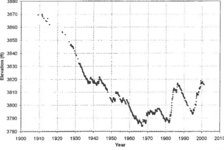
Throughout these years, the maximum amount of water possible was being diverted from the Truckee River at Derby Dam, not only for irrigation in the Project but also for single purpose power generation in Project facilities. These diversions had disastrous effects on Pyramid Lake as is shown on Figure 2. By the 1940s the lake level had dropped 60 feet and the world famous Lahontan Cutthroat Trout became extinct due to a combination of overfishing and the inability of the fish to migrate upstream to spawn. In 1970, the Cui-Ui, a sucker tish found only in Pyramid Lake and a cultural centerpiece to the Pyramid Lake Paiute Tribe, was designated an endangered species. A reintroduced strain of Lahontan Cutthroat Trout in Pyramid Lake has been listed as a threatened species.
3880 3870 3860· 3850
g
3840 c ,g 3830 !:..
iii 3820· 3810 3800 . .. . 3790 3780 1900.
'
..
..
1910 -f--· . "/'"" - ._-,- .; " , '\: .: . _ .... ; ... _ ... ~ 1920 1930 1940 1950 1960 1970 1980 1990 2000 2010 YearFigure 2. Historical Pyramid Lake Water Surface Elevation If the water supply for Nevada interests, including the Project, was to be protected, it was imperative that California and Nevada reach agreement on the division of water in Lake Tahoe and the Truckee River Basin. The two states initiated negotiations in the 1950s to develop a compact on the division of the water. By 1970, after 15 years of negotiations, the two state legislatures approved the compact. however, the United States Congress refused to ratifY the bi-state
The Truckee Canal
agreement because of objections by the Pyramid Lake Paiute Tribe.
As the Pyramid Lake level continued to drop, litigation increased. In November 1972, and supplemented in 1973, the United States District Court, District of Columbia issued a ruling in Pyramid Lake Paiute Tribe ofIndians vs. Rogers C. B. Morton, Secretary of the Interior finding that the Operating Criteria and
Procedures (OCAP) for the Truckee and Carson Rivers, which would permit the diversion of378,000 acre feet of water from the Truckee River at Derby Dam, were arbitrary and not based on the sound exercise of discretion. As a result of this ruling, the diversion in 1974 was not to exceed 288,000 acre feet.
Additionally, detailed criteria defining when and how much water could be diverted were spelled out, checks on individual water rights were required, and actions to minimize waste were to be implemented. This action resulted in additional litigation when TCID, which was not a party in the aforementioned action, did not reduce their diversions or implement the court's order resulting in a 1979 order by the court for TCID to "repay" 1,050,000 acre feet to Pyramid Lake. As of this date, the repayment has not been initiated.
The enactment of the Endangered Species Act in 1969, the need to develop a secure water supply for the rapidly growing Reno-Sparks metropolitan area, litigation involving water quality issues, pressure to reduce the dependency of the Project on the Truckee River, and the imperative that California and Nevada reach a Congressionally approved bi-state agreement on the division of waters of Lake Tahoe and the Truckee River, came together with new urgency in the 1970s. Negotiations among the stakeholders resulted in failed attempts to get federal legislation to solve this myriad of outstanding problems.
A breakthrough in solving the impasse came when the President of SPPCo and the Chairman of the Pyramid Lake Paiute Tribe, met in 1988 and concluded that they held the key to providing a basis for settlement of these many issues. The key was the Floriston Rates. SPPCo would agree to forego the requirement that Floriston Rate flows be met at the run-of-the-river power generation plants when all the water was not needed by downstream water right holders. If the water saved by reducing Floriston Rates flow could be held back in upstream reservoirs, it could be stored as an emergency drought supply for the Reno-Sparks metropolitan area. Water stored in excess of the metropolitan area drought needs could be made available for release for fishery purposes when that water would be most beneficial for the endangered and threatened fish in Pyramid Lake. This concept was developed and incorporated into a Preliminary Settlement Agreement signed by Pyramid Lake Paiute Tribe and SPPCo in 1989.
Using the Preliminary Settlement Agreement as a foundation, California, Nevada, SPPCo, the Pyramid Lake Paiute Tribe, the Fallon Paiute Shoshone Indian Tribes and the TCID, under the sponsorship of Nevada's United States Senator Harry
22 Transbasin Water Transfers
Reid, developed the Negotiated Settlement Act which was adopted into law in 1990 in Public Law IO 1-618.
The Settlement Act apportions the waters of Lake Tahoe and the Truckee River between California and Nevada; authorizes the coordinated operation of all Truckee Basin Reservoirs and Lake Tahoe to enhance fish and wildlife, recreation and water supply benefits; authorizes the acquisition of water rights for additional water supply to wetlands and wildlife management areas; settles long standing litigation and claims between the stakeholders; provides funds to fulfill the Federal trust obligations to Indian tribes; fulfills the goals of the Endangered Species Act by promoting the enhancement and recovery of the endangered Cui-Ui and threatened Lahontan Cutthroat Trout; and protects significant wetlands from further degradation and enhances the habitat of many species of wildlife which depend on those wetlands.
Today diversion from the Truckee River, limited by the current OeAP and by acquisition of agricultural water rights for use in instream flow enhancement and for water quality improvement and protection of the endangered species, has resulted in reversing the decline in Pyramid Lake levels. With a repeat of the hydrology of the last 100 years and the implementation of the Negotiated Settlement, it is estimated that Pyramid Lake will rise over 60 feet.
To implement the Settlement Act, a Truckee River Operating Agreement (TROA) was to be negotiated for the operation of the Truckee River System. Although the Settlement Act was specific in many areas, the very detailed operating criteria required to carry out the mandate to coordinate the operation of all the Truckee River Reservoirs, to protect the existing water right holders and to meet newly defined environmental objectives, has resulted in eleven years of negotiations. These eleven years have demonstrated the axiom that the "devil is in the details". It is anticipated, or hoped, that the TROA will be signed this year and that the environmental documentation will be completed in two years. Subsequently, federal courts in Nevada and California will have to approve required modifications to the Orr Ditch Decree and the 1915 Lake Tahoe Decree.
CONCLUSION
It will have been just over 100 years since the Truckee River transbasin diversion was implemented that the repercussions of that diversion may yet be "settled". However, that is dependent on the TROA being completed and signed by all necessary parties. If not, the litigation and/or negotiations may still go on - for another 100 years? Perhaps.
The Truckee Canal
REFERENCES
District Court of the United States in and for the District of Nevada. September 8, 1944. The United States of America, Plaintiff, vs. Orr Water Ditch Company, et aI, Defendants, Final Decree. In Equity, Docket No. A3.
Rowley, William D. 1992. The Newlands Project: Crime or National
Commitment? Dividing Desert Waters, Nevada Public Affairs Review. University of Nevada, Reno, NY., Number 1, pages 39-43.
United States 10)" Congress. November 16, 1990. Fallon Paiute Shoshone Indian Tribes Water Rights Settlement Act of 1990. Public Law 101-618.
United States, et aI. June 13, 1935. Truckee River Agreement.
Warne, WiIliam E. 1973. The Bureau of RecIamation. Praeger Publishers, New York, NY.
~.
,FIRMING OF M&I WATER RELIABILITY THROUGH THE USE OF UNDERGROUND WATER BANKING
Alan P. Kleinman, Ph.D. I Margot Selig, M.S.2
ABSTRACT
The Central Arizona Project (CAP) transfers water from the Colorado River into the Salt, Gila and Santa Cruz River Basins in central and southern Arizona. The water entitlement for the CAP is one of the lowest priorities on the Colorado River. Due to political agreements between Arizona and California, the CAP essentially bears all shortages on the lower Colorado River. Hence, the CAP water supply is expected to be highly variable from year to year with shortages becoming more frequent as water depletions increase in the Upper Division States. Demand for M&I water for specific areas in central and southern Arizona is relatively constant from year to year and is inconsistent with a highly variable natural supply. The mechanism of banking of water in underground aquifers appears to be a very feasible method of smoothing out the variability in surface water supplies. This paper shows example applications for underground storage in central Arizona and presents some associated costs.
INTRODUCTION
Traditional water storage projects have focused on placing dams on natural streams to form storage reservoirs. Only limited attention has been given to alternative storage in natural underground aquifers. CAP customers and water users have been experimenting with storage of water underground. The United
States, on behalf of Indian tribes in central Arizona, is evaluating alternative"
schemes for underground storage and recovery to increase the reliability of water rights held by the Indians. We will briefly examine both the hydrologic and economic considerations involved in transfers and storage between basins in Arizona.
COLORADO RIVER WATER PRIORITIES
Rights to use Colorado River Water are shared by seven Colorado River Basin States and Mexico, through a multitude of Federal and state statutes, interstate
'Regional Economist, Department of the Interior, Bureau of Reclamation (Reclamation), P.O. Box 61470, Boulder City, Nevada.
2Economist, Reclamation.
26 Transbasin Water Tnlllsfers
compacts, court decisions and decrees, an international treaty, operating criteria, regulations, administrative decisions, and contracts with the Secretary of the Interior (Secretary) collectively known as the Law o/the River.3 The Colorado River Basin is divided into the Upper Basin and the Lower Basin, each of which is entitled to 7.5 million acre feet of Colorado River water annually. The division point between the Upper and Lower Basins is Lee Ferry on the Colorado River, about 18 miles downstream of Glen Canyon Dam.4 By treaty, Mexico is also entitled to 1.5 million acre feet annually.5
The Boulder Canyon Project Act of 1928 (Public Law 70-642) apportioned Arizona 2.8 million acre feet out the 7.5 million acre feet of Colorado River water apportioned to the Lower Basin.b The Colorado River Basin Project Act of 1968 (Public Law 90-537) authorized the Secretary to build, operate, and maintain the CAP. Under the Law o/the River, unused apportionment remains as Colorado River or system water. Even though the Upper Basin is entitled to utilization of 7.5 million acre feet annually, development and utilization in the Upper Basin are far short of its right. Since CAP is the residual claimant in the Lower Basin, any under utilization in the Upper Basin enhances the projected possible diversions of Colorado River water into central Arizona. Presently, Upper Basin developments are depleting Colorado River flows by about 4.8 million acre feet per year. Projected Upper Basin depletions are shown on Figure I. Full development is not expected to occur until about 2050. Total depletions are then estimated to be about 5.9 million acre-feet. Before full development is achieved in the Upper Basin, the unused water is assumed to be part of the CAP water supply.
THE CAP
The CAP provides delivery facilities to move water from the Colorado River into central and south-central Arizona. Water is delivered to augment existing supplies in the Salt River, Gila River, and Santa Cmz River Basins. In addition to existing local surface supplies, alluvial ground water reserves have been widely developed to meet existing water demands.
3Upper Division States are Colorado, New Mexico, Wyoming, and Utah. Lower Division States are Nevada, Arizona, and California. Collectively the seven states are known as the Colorado River Basin States or Basin States.
4The Colorado River Compact of 1922 apportioned water to the Upper and Lower Basins.
~United States - Mexico Water Treaty of February 3, 1944.
~he Lower Division states' apportionments are expressed in terms of a fixed amount of consumptive use for each state, subject to varying provisions at times of surpluses or shortages. These apportionments are: California 4.4 million acre fcct, Arizona 2.8 million acre feet, and Nevada 0.3 million acre feet.
Thousands of acre-feet
3000
2500
2000
1500
1000
500
0
2000
2010
Underground Water Banking
Figure 1. Upper Basin Depletion Projects (Based on 1998 Depletion Schedule)
2020
2030
2040
2050
WalerYears
Note: Arizona has a 50,000 acre-foot apportionment from the Upper Division.
28 Transbasin Water Transfers
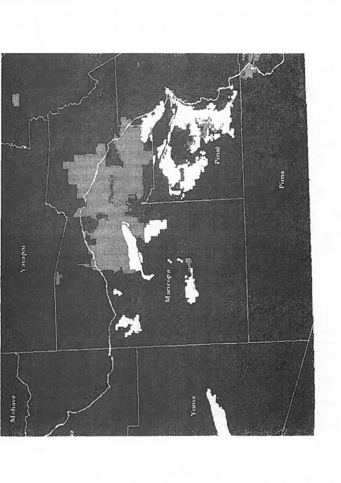
The CAP began limited deliveries of water in 1985. The physical system consists of a series of pumping plants, aqueducts, dams and reservoirs, which extend approximately 336 miles into central Arizona. The geography of the system is shown on Figure 2. The CAP system has the physical capacity to deliver up to 2.2 million acre feet of Colorado River water annually. However, operational limitations reduce the actual annual amount that can be delivered to a range of between 1.6 and 1.8 million acre feet.
CAP WATER PRIORITIES
CAP water rights are a relatively low priority compared to rights held by other Lower Basin users. When less than 7.5 million acre feet is available in the Lower Basin, California receives its full 4.4 million acre foot entitlement, while Arizona and Nevada take reduced quantities. CAP also has a priority junior to most users
in Arizona along the Colorado River.7 Based upon current trends regarding
Arizona's use of Colorado River water along the mainstem, the long-term
consumptive use along the mainstem in Arizona is estimated to be 1.3 million
acre feet, leaving 1.5 million acre feet available for diversion by CAP in a normal year (ADWR 1993).8 The CAP was historically conceived to provide
replacement water for local ground water sources that are over drafted.
In accordance with Federal Reclamation law, uses of CAP water are divided into three major sectors: municipal and industrial (M&I), non-Indian agriculture, and Indian. Originally conceived as essentially an irrigation water replacement project, the CAP has evolved over time to reflect the rapid urban growth in central Arizona and increased awareness of Indian water rights and needs. CAP now has a greater emphasis on water uses for M&I and Indian purposes; non-Indian agricultural water deliveries have become almost incidental.
Originally the CAP allocations were composed of 640,000 acre feet for M&I, 310,000 acre feet for Indians, with the residual (about 465,000 acre feet), after accounting for CAP system losses, available for non-Indian agricultural use. Currently, agreement between the United States and Arizona results in 603,678
7 Rights established prior to September 1968.
8 The Secretary is required to determine when normal, surplus, or shortage
conditions occur in the lower Colorado River. Normal conditions exist when the Secretary determines that sufficient mainstream water is available for release to satisfy 7.5 million acre feet of annual consumptive use in the Lower Division states. Surplus conditions exist when the Secretary determines that sufficient mainstream water is available for release to satisfy consumptive use in the Lower Division states in excess of 7.5 million acre feet annually. Shortage conditions exist when the Secretary determines that insufficient mainstream water is available to satisfy 7.5 million acre feet of annual consumptive use in the Lower Division states.
Underground Water Banking 29