Scienpress Ltd, 2018
Water Resources of the Euphrates River
Catchment
Nadhir Al-Ansari1, Nasrat Adamo1, Varoujan K. Sissakian2, Sven Knutsson1 and Jan Laue1
Abstract
The River Euphrates is the longest River in southwest Asia. Its length reaches 2786 km and drains an area of about 440000 km2, which is occupied by 23 million inhabitants. The Euphrates basin is shared by 5 countries (Iraq 47%, Turkey 28%, Syria 22%, Saudi Arabia 2.97%, Jordan 0.03%) where the first three countries are the main riparian. Climate change and construction of dams in the upper parts of the basin has reduced the flow downstream with time. The flow was about 30.6 BCM in Hit (Iraq) before 1974, and now it is about 4 BCM. Syria and Iraq are facing water shortage and quality deterioration problems, which require national, regional and international cooperation to overcome these problems. Keywords: Euphrates River, Turkey, Syria, Iraq
1 Introduction
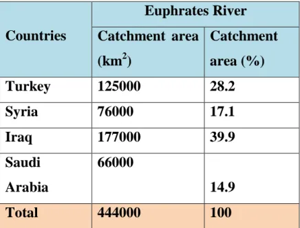
The River Euphrates is the longest river in southwest Asia. Its total length reaches 2786 km and drains an area of about 440000 km2 (Figure 1). The catchment area is shared by 5 countries. These are: Iraq 47%, Turkey 28%, Syria 22%, Saudi Arabia 2.97%, Jordan 0.03% (Figure 1 and Table 1). The estimated population of the catchment area reaches 23 million they are distributed in Turkey (7.13), Syria (5.75) and Iraq (10.12) (ESCWA, 2013). The river rises in Turkey and flows south toward to Syria and then to Iraq. In the southern part of Iraq, it joins the Tigris River at Qurna (Figure 1). In ancient times, the Euphrates River did not join the Tigris and the two rivers reached the Gulf separately (Kornfeld, 2008). The growth of the deltas of both rivers made the area as a very large swamp and led to the formation of Shat Al Arab River (Kornfeld, 2008).
1Lulea University of Technology, Lulea, Sweden 2
The Euphrates River is well nown through the history of civilization. Its history begins about 6000 years ago when enigmatic people inhabited this area due to the presence of water resources. They started simple life and used the marshes for agricultural activities as a start (Sousa, 1981). Small scale and simple irrigation practices and tools were used to lift water from the rivers for irrigation (Figures 2 and 3) or for transportation (Figure 4) (Yannopoulos, et al., 2015 and Mays, 2010). In addition, they noticed the importance of water to survive and they thought that there is a God of water (Figure 5) (Sousa, 1981 and Tamburrino, 2010). Later, they constructed large hydraulic structures and canals, which led to the growth of cities (e.g. Eridu, Ur, Lagesh, Uruk, Nippur, Kish and Sippar) (Figure 3) (McIntosh, 2005, 2017; Rost, 2017). The people learned how to control the waterways by means of canals and dykes (Kornfeld, 2008). They also constructed wastewater facilities and storm water drainage systems (Tamburrino, 2010). These had social consequences where states were formed due to the need for managerial requirements of constructing and operating large-scale irrigation systems and the distribution of water. A legal system was introduced to safeguard and maintain these projects (Sousa, 1981; Kornfeld, 2008; Tamburrino, 2010; Rost, 2017). Historical evidences showed that all the empires of the Mesopotamia (Figure 6) were very concerned with water works because water was so important for their prosperity and survival.
During the twentith century, the lower riparian countries (Syria and Iraq) on the Euphrates River always argued with Turkey (the riparian hegemon) about their share in the water of the Euphrates River. Syria and Iraq reached to the verge of war during the 1976 due to the conflict about water shares of the Euphrates River. In this work, the course of the river and its flow characteristics is discussed. This might help riparian countries and decision makers to understand how to manage the water resources of this basin.
2 Climate
The topography of the Euphrates River basin varies considerably from the headwaters to the mouth of the river. The headwater area is mountainous characterized by Mediterranean climate, where it is dry and hot during summer and cold and wet during winter. Most of the mountains in this area are covered with snow during winter. The mean annual precipitation reaches 1000 mm and decreases gradually toward the south (Figure 3) (Mahmoud, 2010, ESCWA, 2013). When the river reaches Syria, still Mediterranean climate prevails, but less than what it is in the upper parts of the basin. The summer is also hot and dry and winter is wet, but, the mean annual precipitation is about 300 mm in Jarablus. The relative humidity varies from (45 to 55) %, evapotranspiration reaches (2000 to 2800) mm/year and temperature varies from (17 to 20) ○ C (Figure 3) (Mahmoud, 2010).
In Iraq, the part of the basin that is located within the Mesopotamian Plain is characterized by hot summer, where the temperature reaches 50○ C and the mean annual precipitation ranges from (150–200) mm/year (Figure 3) (ESCWA, 2013). Further south, the climate becomes more arid and the mean annual precipitation drops to less than 50 mm/year (Figure 3).
Table 1. The area of the Euphrates Basin
Countries
Euphrates River
Catchment area
(km
2)
Catchment
area (%)
Turkey
125000
28.2
Syria
76000
17.1
Iraq
177000
39.9
Saudi
Arabia
66000
14.9
Total
444000
100
Figure 3: Mean annual precipitation in the Euphrates basin
3 Course of the Euphrates River
The Euphrates River originates in the mountains of the eastern part of Turkey at the Armenian highlands near the city of Erzurum and Lake Van at attitude of 3000 meters (a.s.l.) (Figure 1). The two main tributaries that form the river, are Kara Su and Murat Su. The former rises at Dulmo Mountain north of Erzrum and runs west and then south to join the second tributary. Its total length is 470 km and its drainage area is 40000 km2. The second tributary (Murat Su), rises at the western side of Ararat Mountains and runs toward the west through the Armenian Plateau for about 470 km, and then joins the Kara Su north of Keban city
(Mahmoud, 2010). The Euphrates River runs for about 430 km towards the Turkish-Syrian border and enters Syria near Jarablus, which is 325 meters above sea level (Figure 4). Further south, the Sajur tributary joins the Euphrates River and which then reaches Raqqah city. After this city, the river runs towards the south east and the Balikh tributary joins the river. river till it reaches the Syrian – Iraqi border at Albu Kamal city, which is about 125meters above sea level. (Figure 4) and it enters Iraq at Al-Qaim city. In its reach between Deir ez Zor and Albu Kamal the Khabur tributary joins the river (Figure 1).
Figure 4: Longitudinal section of the Euphrates River (Modified after Mahmoud, 2010).
The main tributaries that join the Euphrates River is Syria are:
1. Sajur tributary: This is the first tributary to join the Euphrates River inside Syria. This tributary rises in Turkey at Eantab area and starts with two branches and it runs for about 108 km (48 km inside Syria) and it joins the Euphrates River south of Jarablus city. Its mean discharge does not exceed 3 m3/s (ESCWA, 2013).
2. Balikh tributary: It rises in Turkey at Urfa area and runs 80 km then enters Syria and runs for 25 km to join the Euphrates River. Number of valleys supply this tributary with water. Its mean discharge reaches 4.4 m3/s (Mahmoud, 2010) or 6.8 m3/s (ESCWA, 2013).
Euphrates River in Syria. It rises near the Turkish-Syrian border area Ras el Ein. Its length is about 460 km with a mean annual discharge, which reaches 57.5 m/s (ESCWA, 2013). This tributary joins the Euphrates River at Busarah city about 60 km southeast Dier ez Zor.
Inside Iraq, the Euphrates channel is asymmetrical where the western bank cuts through the Iraqi-Syrian plateau and is characterized by its steep slope and terraces (2 to 4) (Mahmoud, 2010). The eastern side of the channel have a gentle slope. The main channel contains pools and chutes as well as small islands till it reaches Hit city. The slope of the river channel (1:320 m) is relatively gentler in this stretch compared to the upper parts (Figure 4). The maximum and minimum recorded discharges at Hit city were 7460 m3/s on 13/5/1969, and 55 m3/s on 5/9/1973, respectively.
South of Hit city, the river enters the Mesopotamian Plain. The width of the Euphrates River in this stretch is about 250 m. The asymmetry of the banks does not exist anymore here. The river flows towards the south for about 63 km and it reaches Ramadi city where a Ramadi barrage was constructed to divert some of the water through Warrar canal towards Habaniyah Lake. The length of this channel is 8.5 km and it can discharge up to 2800 m3/s of water. The water in Habaniyah Lake can be brought back to the main river through Dhibban canal, which is located 42 km south of Ramadi city. About 37 km south of Ramadi, another canal joins the river. This canal supplies the river with water from Tharthar Lake when required. Following this the river runs for another 35 km to reach Fallujah city. The river continues to run south of Fallujah for about 110 km to reach Hindiya Barrage where a large branch called Shatt-Al Hilla is supplied with water in addition to a large canal known as Kifel canal. In this reach, the river comes very close to the Tigris Rivere and the distance between the two is about 60 km. The bed of the Euphrates River in this area is about 7 m above that of the Tigris River because it runs parallel to the edge of the Western Desert Plateau. About 18 km south of Hindiya town, the river splits into two branches. The eastern part branch of the river is referred to as the Shamiyah River, while the western branch is known as the Kufa River. The former takes about 40% of the flow, while the latter takes the remainder. Further down for about 92 km to the south, the two branches join again near Mushkhab town. The river splits again at about 25km south of Shanafiya town and rejoins near Smawa city. After Smawa, the river enters Hammar Marsh. During its course within the marsh, it forms a northern branch, which joins the Tigris River at Qurna town and the southern branch join Shatt Al Arab at Karmat Ali town.
4 Flow Characteristics of the Euphrates River
The contribution of water from riparian countries for the River Euphrates is not directly related to the areas of the sub-basins in these countries. ESCWA (2013) states that 89% of the Euphrates flow come from Turkey where only 28%
of the basin area lies in that country. The second largest flow contributor is Syria, where it contributes about 11% which is generated from 22% of the drainage basin. In addition, available long term records covering the period 1938 to 2010 for 4 stations were analyzed by ESCWA (2013) (see table 2) to illustrate the discharge dynamics and trends of the Euphrates River (Figure 5). The results showed that the period 1938 to 1974 represents natural flow of the river. Due to the impounding of Keban Dam reservoir in Turkey and Lake Assad in Syria during winter, 1973-74, the flow of the Euphrates to Iraq was reduced considerably (Kolars and Mitchell, 1991). More reduction was experienced in the following period from 1974 to 1998 which was considered as the period of major infrastructure development in the basin and when in the early 1990s the construction of the Atatürk Dam was started and the great (GAP) irrigation project was underway.
In view of the analyses of flow records, the mean annual flow of the river for the entire period of the record is 26.6 BCM at Jarablus and 27.1 BCM at Hit (Table 2). The records show a continuous decline of the flow with time (Figure 5). Abdullah (2016) showed similar negative trend for Hit station on the Euphrates River with a declining trend 0.19 × 10⁹ m3/y (Figure 6). Table 2 shows that the Euphrates flow was about 30 BCM at Jarablus before building the dams and dropped to 25.1 and 22.8 BCM for the periods after 1974 and 1990, respectively. This negative trend is attributed to building of dams of the Southeastern Anatolia Project (GAP) as well as climate change and droughts. It should be mentioned however, that the construction of dams increases the water loses due to evaporation from their reservoirs. ESCWA (2013) indicates that the records showed four prolonged drought cycles (1958-1962; 1972-1976; 1983-1995; 1999-2011) (see table 2). Furthermore, the discharge of the Euphrates River is declining below the average since 1999. This is due to the effect of the dry weather and building of dams. It is noteworthy to mention that in March 2009, Iraq registered a record low discharge of 250 m3/s on the Euphrates River in entering Iraq.
The hydrograph of the Euphrates River for the period 1938 -1973 representing natural flow at different stations in Iraq and Syria as shown in Figure 7. It can be noticed that there is a high-flow season from March to July due to melting of snow and a low-flow season from August to February. In the same figure, the period 1974-1998 marks the building of dams and the regulation of flow of the river which is clearly reflected on the hydrograph (Figure 7). The water of the high natural flow season is usually stored in the reservoirs and later is released.
Table 2: Summary of annual flow volume for the Euphrates River (1930-2011) (modified after ESCWA, 2013)
STATION (DRAINAGE AREA (km2) PERIOD Discharge (BCM)
Mean Minimum Maximum
Jarablus, Syria (120,000) 1938-2010 26.6 12.7 56.8 1938-1973 30.0 15.0 56.8 1974-1987 24.9 12.7 34.1 1988-1998 25.5 14.4 50.1 1974-1998 25.1 12.7 50.1 1990-2010 22.8 14.4 32.6 Hussaybah, Iraq (221,000) 1981-2011 20.0 8.9 47.6 1988-1998 22.8 8.9 47.6 1999-2010 15.5 9.3 20.7 1990-2010 16.8 8.9 30.7 Hit, Iraq (264,000) 1932-1998 27.1 9.0 63.0 1938-1973 30.6 15.1 63.0 1974-1987 23.1 9.3 31.2 1988-1998 22.4 9.0 46.6 1974-1998 22.8 9.0 46.6 Hindiyah, Iraq (274,100) 1930-1999 17.6 3.1 40.0 1938-1973 19.8 6.6 40.0 1974-1987 15.3 3.1 24.1 1988-1998 13.8 7.7 27.9 1974-1998 14.7 3.1 27.9
Figure 5: Mean annual discharge of the Euphrates River (1937-2010) (modified after ESCWA, 2013).
Figure 6: The inter-annual flow variations of the Euphrates Rivers, 1933– 2011, indicating a declining trend 0.19 × 10⁹ m3/y for the Euphrates (modified after Abdullah,
Figure 7: Mean monthly flow regime of the Euphrates River at different gauging stations for different periods (modified after ESCWA, 2013).
5 Water Schemes of the Euphrates River and Projects
Historical records indicate that Iraq was the principal user of the Euphrates River since 4000BC. In modern time, Iraq was also the first riparian country to utilize the Euphrates water where water works on the river started in the early 20th century when Hindiya barrage was constructed in 1913 (Table 3). Syria and Turkey started to develop the use of the Euphrates water during the 1960’s.
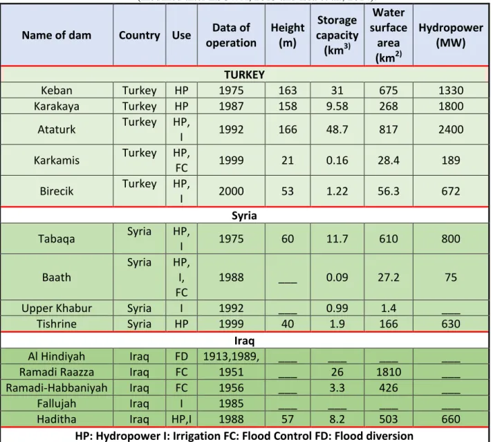
The main objective for Turkey started as to use the river`s energy potential. This is due to the fact that this country can rely on natural precipitation for irrigation purposes and for this reason hydroelectric energy was given priority over other sectors. Keban Dam was the first dam built in the 1960’s and it was completed in 1974 on the Euphrates River to be followed by other dams later on (Table 3). This was followed by the development of what is called as “The Southeastern Anatolia Project- GAP” launched in 1977, which includes 22 dams and 19 hydroelectric power plants on the Euphrates and Tigris Rivers (Table 4). The project covers an area of 74,000 km2 and is supposed to generate 27,367 GWh of hydroelectric energy annually while irrigating 17000 km2 of land. For more details about this project see Al-Ansari (2013&2016); Al-Ansari et al. (2014& 2015); Olcay Unver (1997); Alnajaf News net (2009); GAP (2006).
Syria in its turn depends on agriculture and food security and so started to develop the water of the Euphrates River like Turkey in the 1960’s for irrigation purposes mainly. Four main dams were constructed on the Euphrates River (Table 3). When Syrian started filling the first dam “Tabqa” and forming what known as “Al-Assad Lake” in 1974-75, the Euphrates River was almost dry in Iraq and this
led to a serious tension between the two countries. Water resources mainly used for irrigation. It is estimated that about 95% of the withdrawn water is used for agriculture and the remainder for other uses. The irrigated areas reached 1.4 million ha in 2005 (ESCWA, 2013). Furthermore, ESCWA (2013) stated that there is lack of information in Syria but official data states that irrigated areas in 2010 reached 270,000 ha and this implies that 2,700 MCM of water is required for this purpose. It is noteworthy to mention that the scale of irrigated areas of the GAP project in Turkey and Syria are almost the same. In addition, there are 10 projects under construction to irrigate 323115 ha (ESCWA, 2013). World Bank (2006) indicated that the Syrian Government was planning to double its irrigated area to be 1480000 ha, which will increase its water requirements by 4 BCM. However, recent situation is different in Syria now, wheat yield decreased by 50% and much of the livestock died due to water scarcity (New York Times, 2013; Al-Ansari, 2016).
Iraq was the principal user of the Euphrates water, where Al Hindiya barrages constructed in 1913 followed by other projects (Table 4). The total irrigated area in Iraq estimated at the year 1990 to be 3.5 million ha of which 30% lies within the Euphrates basin (World Bank, 2006). The irrigated land in Iraq before the 1960’s was 5 times as much as it was in Syria and 10 times as much as it was in Turkey (ESCWA, 2013). Estimates of the total potential irrigable areas on the Euphrates basin in Iraq may reached 1.8 million ha (Kliot, 1994). Irrigated areas had reached 1.2 million ha in the past and it is believed to have increased by 1.5 million ha after 2000 (Altinbilek, 2004). One of the main reasons for such investments and developments is was the fear of losing water due to the upstream projects outside Iraq as was the case in the dramatic decrease of the flow during 1973-1975 when both Keban and Tabqa dams where being impounded (Biedler, 2004; World bank, 2006; Kirscbner, and Tirocb, 2012). Therefore, systems of canals linking the Tigris and Euphrates rivers with Tharthar Lake were constructed so that water can be transferred from one river to the other although more fear was focused on the Euphrates River (Figure 8). Irrigated lands were becoming more quickly saline and water-logged due to poor land management and old distribution practices and structures (Figure 9).
Table 3: The constructed dams in the basin of the Euphrates River (modified after ESCWA, 2013 and Issa et al., 2014).
Name of dam Country Use Data of operation Height (m) Storage capacity (km3) Water surface area (km2) Hydropower (MW) TURKEY Keban Turkey HP 1975 163 31 675 1330 Karakaya Turkey HP 1987 158 9.58 268 1800 Ataturk Turkey HP, I 1992 166 48.7 817 2400 Karkamis Turkey HP, FC 1999 21 0.16 28.4 189 Birecik Turkey HP, I 2000 53 1.22 56.3 672 Syria Tabaqa Syria HP, I 1975 60 11.7 610 800 Baath Syria HP, I, FC 1988 ___ 0.09 27.2 75 Upper Khabur Syria I 1992 ___ 0.99 1.4 ___
Tishrine Syria HP 1999 40 1.9 166 630 Iraq
Al Hindiyah Iraq FD 1913,1989, ___ ___ ___ ___ Ramadi Raazza Iraq FC 1951 ___ 26 1810 ___ Ramadi-Habbaniyah Iraq FC 1956 ___ 3.3 426 ___ Fallujah Iraq I 1985 ___ ___ ___ ___ Haditha Iraq HP,I 1988 57 8.2 503 660
Table 4: Dams of the GAP project in Turkey.
River Basin
Name of the Dam Year of completion
Euphrates
Ataturk
Birecik
Camgazi
Hancagrz
Karakaya
Karkamis
Buykcay
Catallepe
Gomikan
Kahta
Kayacik
Kemlin
Koeali
Sirmtas
1992
2000
1998
1988
1987
1999
Suggested
Suggested
Suggested
Suggested
Suggested
Suggested
Suggested
Suggested
Tigris
Batman
Dicle
Kralkizi
Cizre
Garzan
Kayser
Ilisu
Silvan
1998
1997
1997
Suggested
Suggested
Suggested
Under construction
Suggested
Figure 8: Intricate water storage and control system on the River Euphrates inside Iraq (After World Bank, 2006)
Table 5: Population Characteristics within Tigris-Euphrates Basins (modified from Drake, 2007).
Country
Population
(million)
Rate of
Growth
(%)
Projected
population
2025
(million)
Urban
(%)
Turkey
63.9
1.6
78.3
63
Syria
15.5
3.7
31.7
51
Iraq
21.4
3.7
52.6
70
Table 6: Water allocation per capita per year in Turkey, Syria and Iraq (a-Bilen, 2000; b-Turkish Ministry of Foreign Affairs, 2012).
Country
1990
2000
2010
2020
Turkey
3223
2703
2326
2002
a, 980
bSyria
1636
117
880
760
a,780
bIraq
2352
1848
1435
1062
a,950
bFigure 9: A: A boy rested on the mud in a dried-up section of the Euphrates River near Jubaish, Iraq, in June, 2009 B: Gathered salt in a drainage pool on the outskirts of
6 Discussion
Climate change, high population growth rate and development within the riparian countries (Turkey, Syria and Iraq) increased water demand in these countries (Table 5). As a consequence, a number of projects were constructed and others are planned in these countries to attain self-sufficiency in water. Water allocation per capita in the main riparian countries was considered adequate before 1990’s and is expected to decrease with time (Table 6).
The quantity of water required for irrigation within the Euphrates basin is 15.7, 11 and 13 km3 for Turkey, Syria and Iraq, respectively. When the GAP project is completed, then 80% of the Euphrates River discharge will be controlled by Turkey (Beaumont, 1995, Alyaseri, 2009, Robertson, 2009). That means a reduction of 40% and 90% for Syria and Iraq, respectively. The first and the second used to receive 21 km3 and 29 km3 before the 1990’s. The overall water supply in Turkey reaches 195 km3 annually, while the demand does not exceed 15.6 km3 (Kamona, 2009) and projected future water demand for 2015 was to be about 26.3 km3 (Al-Ansari and Knutsson, 2011). The Turkish Government was planning to export the excess water (Al-Ansari and Knutsson, 2011). This is going to have very negative consequences on Iraq where there will be a high water shortage, more land degradation, further deterioration of water quality and more drying of marshes.
As a result, Syria and Iraq are facing water shortage and water quality deterioration problems; now and more in the future.
7 Conclusions
Since the dawn of civilization, number of cities was built within the Euphrates River basin. This river is the longest river in southwest Asia and now there are about 23 million people who rely on the water of this river to maintain their living. Before 1974, hydraulic structures and irrigation projects were not as many or extensive as to affect the discharge of the river so much. After that and due to increased population growth rate and development, the riparian countries started to utilize its water extensively. Turkey started an ambitious plan to develop the GAP project in this context. In addition, the Middle East is experiencing drought periods due to climate change, which made water shortage problems more severe. As a consequence, the lower riparian countries (Syria and Iraq) are experiencing water shortage problems and deterioration of water quality. Large agricultural areas are expected to turn into desert in the near future. This has caused friction among riparian countries in the past and could lead to even greater conflicts in the feature. International, regional and national actions are mostly needed, and
stronger cooperation is required to overcome this problem and to avoid it’s the negative consequences on the people and the environment within the river’s basin.
References
[1] Abdullah, A.D., 2016, Modelling Approaches to Understand Salinity Variations in a Highly Dynamic Tidal River: The case of the Shatt Al-Arab River, PhD thesis, Delft University of Technology and of the Academic Board of the UNESCO-IHE Institute for Water Education
[2] Al-Ansari, N.A.,2013, Management of Water Resources in Iraq: Perspectives and Prognoses. Journal of Engineering, 5, 667-668. http://dx.doi.org/10.4236/eng.2013.58080
[3] Al-Ansari, N.A., 2016. Hydro-Politics of the Tigris and Euphrates Basins, Engineering, 8, 3, 140-172.
[4] Al-Ansari, N.A., Ali, A., Knutsson, S., 2014. Present conditions and Future Challenges of Water Resources Problems in Iraq. J. Water Resources and Protection, 6, 12, 1066-1098.
[5] Al-Ansari, N.A., Ali, A.A. and Knutsson, S., 2015. Iraq Water Resources Planning: Perspectives and Prognoses, ICCCE 2015: XIII International Conference on Civil and Construction Engineering, Jeddah, Saudi Arabia, 26-27 January, 2015, 2097-2108.
[6] Al-Ansari, N.A. and Knutsson, S., 2011, Toward Prudent management of Water Resources in Iraq, Journal of Advanced Science and Engineering Research, V. 1, 53-67.
[7] Alnajaf News net,2009. “The GAP project and its negative implications on Iraq.
http://www.alnajafnews.net/najafnews/news.php?action=fullnews&id=31503 last accessed 2 February, 2018.
[8] Altinbilek, D., 2004, Development and Management of the Euphrates-Tigris Basin, International Journal of Water Resources Development, 20,1, 15-33. [9] Alyaseri, S., 2009, GAP project: Dangerous consequences on life in Iraq,
Official site of Iraqi Council for Peace and Unity, http://www.marafea.org/paper.php?source=akbar&mlf=copy&sid=11556 [10] Beaumont, P., 1995, Agricultural and environmental changes in the upper
Euphrates catchment of Turkey and Syria and their political and economic implications, Applied Geography, Volume 16, Issue 2, April 1996, 137-157. [11] Biedler, M., 2004, Hydropolitics of the Tigris-Euphrates River Basin with
Implications for the European Union, “CERIS” Centre Européen de Recherche Internationale et Stratégique, Research Papers No. 1, 1-44.
[12] Bilen, O., 2000, Turkey and Water Issues in the Middle East (2nd edn.). (Ankara: Republic of Turkey, Prime Ministry, Southeastern Anatolia Project Regional Development Administration).
[13] Drake, C.,2007, Water Resource Conflicts in the Middle East, J. Geography, 96,1, 4-12.
[14] ESCWA (Economic and Social Commission for Western Asia), 2013. Inventory of Shared Water Resources in Western Asia, Salim Dabbous Printing Co., Beirut, Lebanon, 626p.
[15] GAP, “South-eastern Anatolia Project: latest situation”, 2006. http://www.gap.gov.tr/English/Genel/sdurum.pdf last accessed 2 February, 2018.
[16] Kamona, H.A., 2003, The effect of Turkish water policy on Iraq, AlSabah Iraqi news net, 17/05/2003, Baghdad, Iraq.
[17] Kirscbner, J. and Tirocb, K., 2012, The waters of Euphrates and Tigris: An International Law Perspective, Max Planck Yearbook of United Nations Law, 16, 329-394.
[18] Kliot, N. ,1994, The Geopolitics of Inequality: The Tigris-Euphrates Drainage Basin. In Water Resources and Conflict in the Middle East, Routledge Pub., London/New York.
[19] Kolars, J. F. and Mitchell, W. A., 1991, The Euphrates River and the Southeast Anatolia Development Project, Southern Illinois University Press, Carbondale, USA.
[20] Kornfeld, I.E., 2008, Mesopotamia: A History of Water and Law, Chapter 2, in Dellapenna, J.W. and Gupta, J. (eds.), The Evolution of Law and Politics of Water, Springer, The Netherlands.
[21] Mays, L.W., 2010, A Brief History of Water Technology During Antiquity: Before the Romans, in Ancient Water Technologies, Springer, Heidelberg. DOI 10.1007/978-90-481-8632-7
[22] Mahmoud, F., A., 2010. Surface Water Resources of Euphrates and Tigris Rivers Basins in Iraq, M. Sc. Dissertation, College of National Defense, University of National Defense, Baghdad, Iraq.
[23] McIntosh, J.R., 2005, Ancient Mesopotamia, New perspectives, ABC – CLIO, Inc, California USA.
[24] McIntosh, J.R., 2017, Mesopotamia and the Rise of Civilization, ABC – CLIO, Inc, California USA.
[25] New York Times, 2013, Without Water, Revolution, May 18, 2013. http://www.nytimes.com/2013/05/19/opinion/sunday/friedman-without-water -revolution.html?_r=0 Last accessed October 25, 2017.
[26] Olcay Unver, I.H., 1997. “Southeastern Anatolia Project, GAP, International Journal of Water Resources Development”, 13, 4, 453 – 484.
[27] Robertson, C., 2009, Iraq Suffers as the Euphrates River Dwindles, The New York Times, 13 July 2009.
http://topics.nytimes.com/topics/reference/timestopics/people/r/campbell_rob ertson/index.html?inline=nyt-per last accessed 15 February, 2018.
[28] Rost, S., 2017, Water management in Mesopotamia from the sixth till the first millennium B.C., Wiley Interdisciplinary Reviews: Water, 4, 5, 1-23. DOI: 10.1002/wat2.1230
[29] Sousa, A., 1981, History of Mesopotamian Civilization, Part 1, Ministry of Irrigation press, Baghdad, Iraq.
[30] Yannopoulos, S.; Lyberatos, G., Theodossiou N., Li W.; Valipour M.; Tamburrino, A. and Angelakis, A.N., 2015, Evolution of Water Lifting Devices (Pumps) over the Centuries Worldwide, Water, 7, 5031-5060. doi:10.3390/w7095031
[31] Tamburrino, A., 2010, Water Technology in Ancient Mesopotamia, Chapter 2, in Mays, L.W. (ed.), Ancient Water Technologies, Springer, Heidelberg. DOI 10.1007/978-90-481-8632-7
[32] Turkish Ministry of Foreign Affairs, 2012, Water Issues between Turkey, Syria and Iraq, Department of Transboundary Waters. http://sam.gov.tr/wp-content/uploads/2012/01/WATER-ISSUES-BETWEEN -TURKEY-SYRIA-AND-IRAQ.pdf, Last accessed August 30, 2015
[33] World Bank, 2006, Iraq: Country Water Resources, Assistance Strategy: Addressing Major Threats to People’s Livelihoods,” Report No. 36297-IQ, 97p.