Scientific Press International Limited
Hydrological Characteristics of the Tigris and
Euphrates Rivers
Nadhir Al-Ansari1
, Nasrat Adamo2
and Varoujan K. Sissakian3
Abstract
The Middle East is considered as an arid to a semi-arid region where the annual rainfall does not exceed 166 mm/y. Water shortage issue within this area is one of the prime issues of friction and tension between the countries of the Middle East. Iraq is located within the Middle East. It covers an area 437072 square kilometer with a population of 38.27 million. Iraq used to be considered rich in its water resources due to the presence of the Tigris and Euphrates Rivers. The catchments of these rivers are shared with Turkey, Syria, Iran and Saudi Arabia. Building of dams in the upper parts of the catchment since the seventies as well as climate change affecting the region caused water shortage problems in Iraq. The flow of the two main rivers decreased tremendously. To overcome this problem, prudent water management plan is required. Such plan should include the use of non-conventional water resources, new irrigation techniques, public awareness, and new water management strategies. This will help to reduce the impact of water shortage problems.
Keywords: Tigris River; Euphrates River; Iraq
1 Lulea University of Technology, Lulea 971 87, Sweden.
2 Consultant Engineer, Norrköping, Sweden.
3 Lecturer, University of Kurdistan, Hewler, KRG, Iraq and Private Consultant Geologist, Erbil,
Iraq.
Article Info: Received: October 20, 2019. Revised: November 11, 2019.
1.
Introduction
The Tigris and Euphrates Rivers are the two main rivers forming the Mesopotamian Plain. Five countries share the catchment area of the Tigris and Euphrates Rivers (Figure 1 and Table 1). These countries are Iraq, Turkey, Iran, Syria and Saudi Arabia. The southern part of this area is known as the “Mesopotamia”. The Mesopotamia region is one of the oldest regions witnessing the dawn of civilization. South of the Mesopotamia was occupied by Sumerians since about 8000 years ago. Civilization started at Sumer due to Mesopotamia's plentiful water resources and lush rivers. The first form of irrigation to improve agricultural production was invented in this region as well as devising the first written communication, or handwriting. This work continued and the two main rivers “Tigris and Euphrates” were used even to transport grains (Figure 1). For this reason, the Sumerians were deepening and straightening many of the existing canals. In view of these activities it is called the hydraulic civilization.
It should be mentioned; however, that the Mesopotamia saw wave after wave of conflicts despite its productive wealth and prosperity for many millennia and this is well reflected through myths, legends and historical accounts that survived from earlier times, e.g. Epic of Gilgamesh [1] (George, 2000). International attacks on water supply systems during wars [2] was very common and the invasion of the Mongols in the thirteenth century, destroying majority of elaborate canal systems, built centuries before, is a good example of such wars. After this period and until the nineteenth century, more rural society was noticed in the area creating a huge dependence on irrigated agriculture for its survival.
Recently, the Middle East (of which these countries are parts) is characterized by its water shortage problems where most of the countries have acute water scarcity
problems and the available allocation per capita is less than 500m3 of renewable
Figure 1. Catchments area of the Rivers Tigris and Euphrates ([10]).
Table 1. The area of the Tigris and Euphrates Basins.
Country
Tigris River Euphrates River
Catchment area (km2) Catchment area (%) Catchment area (km2) Catchment area (%) Turkey 57614 12.2 125000 28.2 Syria 834 0.2 76000 17.1 Iraq 253000 58 177000 39.9 Iran 140180 29.6 - - Saudi Arabia - - 66000 14.9 Total 473103 100 444000 100
2.
Climate
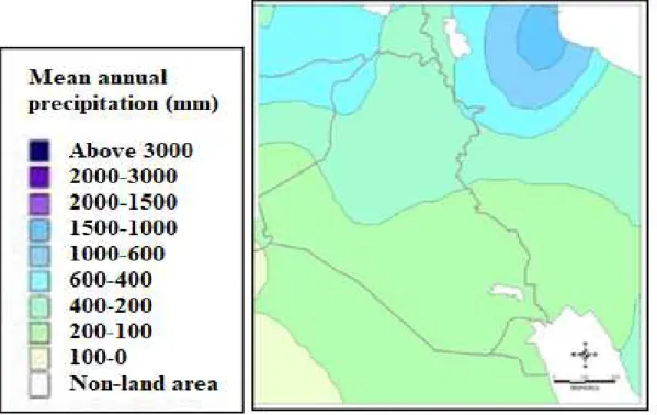
The Euphrates and Tigris basins are characterized by different climatic zones. In Turkey, the climate is more of Mediterranean type 75 and gradually changes to an increasingly hot and dry, arid, climate toward the south. In the headwater area, the summer is dry while winter is cold and wet and precipitation predominates in autumn, winter and spring seasons. In the winter; however, snow fall takes place. The mean annual precipitation varies from over 1000mm in Turkey to about 150mm in Syria and about 75mm in the southern part of Iraq (Figure 2) [7,10,11,12]. The
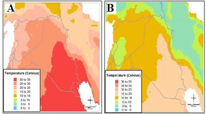
temperature ranges from -350C in the winter at the headwater region to about
(40-50)0 C in the summer in Iraq (Figure 3).
Figure 2: Mean annual precipitation in the Tigris and Euphrates Basins
Figure 3: Maximum, A and minimum B, daily temperature in the Tigris and Euphrates basins.
http://images.search.yahoo.com/search/images?_adv_prop=image&fr=yfp-t-621&va=Maps+of+climate+of+Iraq
3.
Courses of the Tigris and Euphrates Rivers
3.1 Euphrates River Course
The River Euphrates is the longest river in Southwest Asia, where its length is
2786km. Its basin area is 440,000km2 shared by 5 countries (Iraq 47%, Turkey 28%,
Syria 22%, Saudi Arabia 2.97%, Jordan 0.03%) (Figures 4 & 5). The riparian countries are Iraq, Syria and Turkey (Figures 2 and 3). The mean annual flow of the river at Jarablus in Syria; before 1973 was 30 Billion Cubic Meters (BCM), and was reduced to 25 BCM after 1973; due to the construction of dams. The population of the basin reaches 23 million [10]. About 7.13, 5.75 and 10.12 million live in Turkey Syria and Iraq, respectively.
The Euphrates River originates in the highlands of Armenia near Erzrum city about 3000m above sea level, (a.s.l.). Its headwaters tributaries are Karasu and Muratsu. The former known as Western Euphrates, originates in the Kargapaza north of the city of Erzurum and it flows westwards over the Erzurum Plateau for more than 300km before it merges with the Muratsu. Convergence of many springs in the Ala-dag area forms the Muratsu River, or Eastern Euphrates. One of the Murat’s main sources is the Urat Spring, west of Mount Ararat to the north of Lake Van. The river flows westwards through the Armenian Highlands over a distance of almost 500km, 5km north of the city of Keban and near the city of Ekbazari, the two rivers join together.
Figure 4: Euphrates River Basin (After [10]).
At Keban area, a dam is constructed with a total reservoir capacity of 30.5x10⁹m3.
The average annual flow of the river in this area is about 672m3/s. The united river
length in Turkey is 455km and its catchment area is 125000km2. The shape of the
catchment area of the river in Turkey is fan shaped, which collects runoff at rainy periods in a short period of time causing sudden flood peaks.
The Euphrates River enters the Syrian border near Jorablus. In Syria, three tributaries join the River Euphrates they are:
i. Sajurr River: This river stems from the confluence of two streams in Turkey,
the Ayfinar Deresi and the Bagırsak Deresi and it joins the Euphrates 20km downstream of the city of Jarablus from the right. Its total length is 108km of which 60km in Turkey and 48km in Syria. The catchment area is 2,860
km2, 40% of which lies in Syria and 60% in Turkey. Its average discharge
is 3m3/s with maximum discharge value of 25 m3/s which was recorded
during flood periods in the 1960s and a minimum discharge of (0 – 0.5)m3/s
during dry periods.
ii. Belaikh River: The source of the water of this river is Ain al Arous Spring
near the Syrian border town of Tell Abyad. It also receives water from a number of intermittent streams and ephemeral wadis, including the Wadi Qaramogh and the Wadi al-Kheder as well as the Jallab River. It joins the Euphrates River from the left south of Raka city downstream Tabaka dam around 80km south of the Syrian – Turkish borders. The length of this river is 196km; of which 89km lies in Turkey and 107km lies in Syria. Its average
discharge is 6.8m3/s, with a maximum discharge of up to 35m3/s during
floods. The catchment area is 13,600km2; it is shared between Syria (38%)
and Turkey (62%).
iii. Khabor River: This river originates both in Syria and in Turkey. The
catchment area is 36200km2 shared by Turkey (28%) Syria (66%) and Iraq
(6%). This river joins the Euphrates River south of Dier Al-Zor city and its
mean daily discharge is 57.5m3/s and could reach during flood 500 m3/s.
After 1980 the mean annual discharge was reduced by about 55%, 52.4% and 44% at Ras al Ain, Tal Tamer and Hasakah, respectively [10]. Its length is 388km; of which 80km lies in Turkey. Four small streams, i.e. Jaja, Jabjab, Etehad Aracha Alsaghir and Etehad Aradha Alkabeer, join this river. The Euphrates River runs toward the Syrian – Iraqi borders at Albu Kamal and enters Iraq at an elevation of 165m (a.s.l.) at Hussaybah. The length of the river in Iraq is 1160km. The river trends toward the east and southeast to reach Anah city; 100km south of Hussaybah. The channel of the river is characterized by its shallow depth, large width and meanders and its slope is 1:320m. It runs 200km to reach Hit
city where the maximum and minimum recorded discharges were 7460m3/s on
13/5/1969, and 55 m3/s on 5/9/1973, respectively.
The Euphrates River runs south of Hit for 63km to reach Ramadi city with a width of 250m. In this area, Ramdi barrage was constructed in 1948 to supply Warrar channel with water. The excess water of the River Euphrates is supplied to Habaniya
Lake through this channel. The length of Warrar stream is 8.5km and it was
designed to discharge 2800m3/s of water. The stored water in Habaniyah Lake can
be returned back to the River Euphrates through Dhiban channel, which is located 42km south of Ramadi city. In cases of high floods that Habaniyah lake cannot accommodate, it was connected to Razazah lake and then to Abudibis marsh to release excess water.
The Euphrates River flows 72km south of Ramadi city to reach Faluja town, where a complex of canals system was constructed at this section of the river. In this section, there is a canal that supplies the Euphrates River with water from Tharthar Lake during periods of drought. This canal joins the river 35km north of Faluja town,
and it is designed to discharge water up to 1,100 m3/s and has a diversion, which
can supply excess water to the Tigris River; if required. This diversion canal is 65km long. After 110km toward the south, the Euphrates River reach Hindiyah barrage, which was constructed in 1914 (this old barrage was abandoned in 1989 after the construction of a new barrage four kilometers upstream the old one). The Euphrates River channel upstream Hindiyah is higher by 7m than the Tigris River channel because it runs on the edge of the western plateau and for this reason the old irrigation projects were all dug from the Euphrates River running toward the Tigris River. From Hindiyah, the river flows for 18km south toward Kifil town and it is referred to as “Hindiyah River”. The river splits to eastern channel, Shamiyah, which takes 40% of the flow and western channel, Kufa, taking the remaindering 60% of the flow south of Kifil town. There are various regulating schemes established for a number of irrigation projects at Shamiyah River, i.e. Danaieb Alshanafiyah, Kufa barrage, Al Abbasiya barrage, Shalal Danaieb Alshanafiyah, Khuman and Naghshiyah regulating schemes. The river flow 99km toward Shanafiyah town. This channel joins the Euphrates River again 8km upstream of Shanafiyah town. The other channel “Kufa”, runs to Abu Skhair town and splits into two main channels. On the right of the main channel, the small channel, on the right of the main channel supplies four small irrigation streams. The main channel south of Abu Skhair town is known as Mushkhab River; where Mushkhab barrage was established. The water flows to the south to reach Diwaniyah city and it again splits and joins again to form one channel. This channel joins Shamiyah channel again at Shanafiya town. There are two more barrages (Al kufa and Al Shanafia). The former is part of Kifel-Shanafeya irrigation project and it arrange the water flow from Kufa and Abbasiya Rivers.
The river continues to run south for 105km where it reaches Smawah city. After that, the river Euphrates reaches Nasiriyah city. It should be mentioned; however, that this section of the river, Smawah – Nasiriyah section, has a number of irrigation projects and small intake stream. South of Nasiriyah city, the river runs toward Souq Al-Shiyokh town and then enters Hammar Lake. Two channels leave Hammar Lake. The first joins the Tigris River at Qurna town, while the other, the southern one, joins Shatt Al-Arab River at Qarmat Ali.
3.2 Course of the River Tigris
The Tigris River is the second longest river in Southeast Asia, where its length
reaches 1800km. Its basin covers an area of 221000 km2 in 4 riparian countries,
Turkey 24.5%, Syria 0.4%, Iran 19% and Iraq 56.1%, (Figures 6 and 7). The river merges with the Euphrates River in the southern part of Iraq forming Shatt Al-Arab (Figures 6 and 7). The population within the Tigris basin is about 23.4 million inhabitants [10]. About 18 million live in Iraq, 3.5 million in Turkey, 1.5 million in Iran and the remainder 50000 people in Syria. The river flow for about 400km in Turkey. It rises at the southeastern slope of Taurus Mountains at two sites, the western site is located near Diar Bakir city, 1,500 m (a.s.l.), with a discharge of 64
m3/s, while the eastern site, known as Butman Su, near Sinan city a 2,700m (a.s.l.)
with a discharge of 96.3m3/s. The river runs in a narrow valley bounded by Mardin
Mountain range from the right and Raman Surat Hills from the left. Further down, another tributary, Karzan, joins the river near Bishwi village. The river runs south through rough mountainous area till tributary merges with, Hazu, near Zeu village 240km north of the Turkish – Iraqi borders. The annual average discharge of this
tributary is 59m3/s. The river then runs in a plain area and merges with the Butan
Su River, with a discharge of 20.3m3/s to form the main stream of Tigris River. The
river forms the Syrian – Turkish borders for about 47km and then flows through Iraq for more than 1,350km.
Figure 7: Percentages of the catchment area of the River Tigris
The River Tigris enters Iraq 4km north Fiesh Khabur town near Zakho town. It is joined by its first tributary inside Iraq “Khabur River”. This tributary is 100km long,
its catchment area is 6,268km2 with an average with an average discharge of
68m3/sec and maximum and minimum discharge of 1,270m3/s ,11/4/1963, and
8m3/s ,6-14/9/1962, respectively. The river runs south about 188km in a hilly area
to reach Mosul city. At this city, the average, maximum and minimum discharge of
the river is 668m3/s, 7,740m3/s, 2/5/1972, and 85m3/s, October, 1935, respectively
and the elevation of the channel bed is 225m (a.s.l.).
Further south of Mosul, 49km, toward Shirqat town, the River Tigris joins its largest tributary, the Greater Zab River. The catchment of this tributary lies in Turkey and Iraq. Its total length is 437km with a mean, maximum and minimum discharges of
450m3/s, 9,710m3/s, 2/4/1969, and 60m3/s, 22/11 and 4/12/1958, respectively. It
supplies 28.7% of the Tigris water. The Tigris River continues south toward Fatha gorge. About 30km north of Fatha, the Lesser Zab tributary joins the river Tigris.
The total catchment area of this tributary is 22,250km2 of which 5,975km2 lie in
Iran and the remainder in Iraq. The total length of the river is 456km. The mean
discharge of the Lesser Zab is 227m3/sec, the maximum and minimum discharges
are 3420m3/s, 8/3/1954, and 6m3/s, 14/5/1964, respectively. The river Tigris mean
flow at Fatha is 1,349 m3/s, and the maximum and minimum discharges are
16,380m3/s, 3/4/1969, and 200m3/s, October 1930, respectively.
The Tigris River further south 20km north of Samara city and then Balad city. The Adhaim tributary joins the Tigris River 15km south of Balad town. This tributary
drains an area of 13,000km2 lying within Iraq. Its length is 330 km. The mean daily
discharge is of the order of 25.5m3/s; while the maximum discharge reached
3,520m3/s, 19/10/1960. It runs almost dry during June to November each year. The
banks of the river Tigris south its confluence with Adhaim tributary are below the maximum flood peak level by 3m from the left and 1.8m from the right.
Further to the south, the river reaches Baghdad. At Baghdad the mean annual
discharge is 1140m3/sec, while the maximum and minimum discharges are
7,640m3/s, on 12/2/1941, and 163m3/s, on October, 1955, respectively 7,640m3/s,
12/2/1941, and 163m3/s, October, 1955, respectively. The slope of the channel is
6.9cm/ km. About 31km south of Baghdad, the last main tributary “Diyala” joins
the Tigris River. Diyala’s drainage basin is 31,896km2 of which 20% lies in Iran
and the rest in Iraq. The mean daily discharge is 182m3/s, while the maximum and
minimum discharges are 3340m3/s, 25/3/1954, and 12m3/s, 7/9/1960, respectively.
The Tigris channel is characterized by its large number of meanders downstream the confluence of the Tigris – Diyala River and the river discharge steadily decreases downstream due to losses. These losses include evaporation, infiltration and mainly water withdrawal through irrigation canals. Important irrigation canals include: Gharaf, south of Kut city, Great Majar, Musharah and Kahla’a, south of Amarah city, and Majariah canal, south of Qalaat Salih town. This stretch of the river is well known by the occurrence of big marshes on both sides of the Tigris River. There are many small streams running from Iran toward Iraq where they discharge their water in the marshes, e.g. Karkha stream discharging its water in Hiwazah marsh. The Tigris channel reaches its minimum width at Kasarah area south of Amarah city. At Qalaat Salih town the mean daily discharge of the river is
80m3/s. Downstream this city, the river joins the Euphrates River at Qurnah town
forming Shatt Al-Arab River (Figure 6).
3.3 Course of the River Shatt Al Arab
The Shatt Al-Arab River is formed after the confluence of Tigris and Euphrates Rivers at Qurnah town in Iraq (Figure 7). Its total length is 193km and its drainage
area is 80,800km2 [13]. Its width is about 300m near Qurnah town and increases
downstream to 700m near Basra city and to about 800 m near its mouth at the gulf area [10]. Karun and Karkha Rivers usually contributes 24.5 and 5.8 billion cubic meters (BCM) annually, respectively (Figure 8). This forms about 41% of the water
of Shatt Al-Arab. Its annual discharge at Fao town reaches 35.2 x10⁹m3. The Shatt
Al-Arab River is characterized by its high sediments, which resulted in formation of large number of islands along its course.
4.
Flow of the Rivers
The flow of the Tigris and Euphrates Rivers is highly affected by climate change and construction of dams in the upper part of the catchment area (Table 2 and Figure 9). Long term flow records clearly elucidate two periods. One period represents the natural flow, while the other represents the flow after construction of dams (Figures 10 & 11).
[10] compared the flow records for the period 1930 – 2011 of the River Euphrates in four stations, Jarablus in Syria, 1938 – 2010, Hussaybah, 1981 – 2011, Hit, 1932 – 1998, and Hindiyah, 1930 – 1999, in Iraq. They selected common periods for comparison purposes (Table 3).
The natural flow period was considered as 1938 – 1974. The flow rates changed with the beginning period of dam`s constructions. The mean annual flow for the entire period, 1938 – 2010, is 26.6 BCM at Jarablus and 27.1 BCM at Hit (Table 3). In the natural flow conditions, the high flow period is March – July, which represents the snow melt period in the upper parts of the catchment area, while the low flow period is August – February (Figure 12a). After the construction of Keban Dam in Turkey in 1974 and later Tabaqa Dam in Syria, the flow was highly regulated (Figure 12b). Finally, Ataturk Dam also affected the flow when it was in operation in 1992.
Table 2: The constructed dams in the basin of the Euphrates Tigris Rivers(after [14]).
Name of dam Country Use Data of operation Height (m) Storage capacity (km3) Water surface area (km2) Hydropower (MW) Major dams in the River Euphrates basin
Ataturk Turkey HP, I 1992 166 48.7 817 2400 Birecik Turkey HP, I 2000 53 1.22 56.3 672 Karakaya Turkey HP 1987 158 9.58 268 1800 Karkamis Turkey HP, FC 1999 21 0.16 28.4 189 Keban Turkey HP 1975 163 31 675 1330 Baath Syria HP, I, FC 1988 ___ 0.09 27.2 75 Tabaqa Syria HP, I 1975 60 11.7 610 800 Tishrine Syria HP 1999 40 1.9 166 630 Upper Khabur Syria I 1992 ___ 0.99 1.4 ___ Al Hindiyah Iraq FD 1913,1989 ___ ___ ___ ___ Haditha Iraq HP,I 1988 57 8.2 503 660 Fallujah Iraq I 1985 ___ ___ ___ ___ Ramadi-Habbaniyah Iraq FC 1956 ___ 3.3 426 ___ Ramadi Raazza Iraq FC 1951 ___ 26 1810 ___
Major dams in the River Tigris basin
Batman Turkey HP,I 1998 71 1.18 49.2 198 Devegecidi Turkey I 1972 33 0.2 32.1 ___
Cag-cag Turkey HP,FD 1968 14
Dicle Turkey HP,I 1997 75 0.60 24 110 Goksu Turkey I 1991 46 0.06 3.9 ___ Kralkizi Turkey HP 1997 113 1.92 57.5 90 Al-Adheem Iraq HP,I 1999 ___ 1.5 ___ ___ Derbendikhan ,Diyala, Iraq I 1961 128 3 114 ___ Dibbis ,L. Zab, Iraq I 1965 22 0.05 32 ___ Diyala Iraq I 1969 12 ___ ___ ___ Dokan ,L. Zab, Iraq HP,I 1959 116.5 6.8 270 400 Hamrin ,Diyala, Iraq I, FC 1981 40 3.56 450 50 Mosul Iraq HP,I,FC 1986 113 11.1 380 750 Samarra-Tharthar Iraq FD, I, HP 1956 ___ 72.8 2170 87 Dez Iran HP,I 1962 203 3.46 ___ 520 Karkheh Iran HP,I,FC 2001 128 7.8 ___ 400 Karun Iran HP,I 1977 200 3.14 54.8 1000 Marun Iran HP,I 1998 165 1.2 25 145
For the flow of the Tigris River, the available records date back to 1931(Table 4). The natural uncontrolled period for this river is 1931 – 1973. After that and until 2005, major water infrastructure projects were implemented in the basin and the flow cannot be considered natural any longer. The mean annual flow for the period 1931 – 2011 is 20 BCM at Mosul gauging station. The maximum and minimum flows were 43.1 BCM, 1969, and 6.5 BCM, 1999, respectively at Mosul. The tributaries of the Tigris River contribute an annual flow volume of the 25 BCM to the Tigris River. Before the 1970s the high period flow of the Tigris River was extending from February to June, while the low flow period extending from July to January (Figure 12a). The increase in flow is usually the result of snow melting and high precipitation in Turkey and Iran. The low flow period starts at July and ends in January (Figure 12a). After 1973, the flow decreased due to construction of dams (Figure 12b). The decrease of flow can be noticed clearly in Figure (13) at Baghdad station.
The schemes built on the River Tigris have decreased the average monthly discharge of the river according to the records of the Sarai Baghdad gauging station
from 1207m3/s for the period 1931 – 1959 to 927m3/s for the period 1960 – 1999.
For the period 2000 – 2013, the discharge dropped to 522m3/s. The Tigris River
hydrograph at Sarai Baghdad (Figure 13) shows that the maximum flow takes place during April and May and it became flatter and flatter since 1990 due to the reduction of flow. This flattening is mainly due to the effect of the regulating schemes in Iraq, Iran and Turkey as well as climate change [7,11, 17].
In view of the above, it can be noticed that there is reduction in the flow in all gauging stations on the Tigris and Euphrates Rivers (Table 4).
Figure 9: Schematic Diagram for Water Storage and Control System in Iraq (after [15]).
Figure 10: Average monthly recorded discharges of Euphrates River at Hit and Haditha stations for the period 1948-2007 (after [16,17]).
Figure 11: Average monthly recorded discharges of Tigris River at Sarai Baghdad station for the period 1960-2012(after [16,17]).
0 1000 2000 3000 4000 5000 6000 7000 Jan.MaySept.Jan.MaySept.Jan.MaySept.Jan.MaySept.Jan.MaySept.Jan.MaySept.Jan.MaySept.Jan.MaySept.Jan.MaySept.Jan.MaySept.Jan.MaySept.Jan.MaySept. Months F lo w ( c u m e c s ) Years 1948 - 1972 @ Hit Average (967 cumecs)
Years 1985 - 2007 D/S Haditha Dam Average (553 cumecs) 0 500 1000 1500 2000 2500 3000 3500 ja n -6 0 ja n -6 1 ja n -6 2 ja n -6 3 ja n -6 4 ja n -6 5 ja n -6 6 ja n -6 7 ja n -6 8 ja n -6 9 ja n -7 0 ja n -7 1 ja n -7 2 ja n -7 3 ja n -7 4 ja n -7 5 ja n -7 6 ja n -7 7 ja n -7 8 ja n -7 9 ja n -8 0 ja n -8 1 ja n -8 2 ja n -8 3 ja n -8 4 ja n -8 5 ja n -8 6 ja n -8 7 ja n -8 8 ja n -8 9 ja n -9 0 ja n -9 1 ja n -9 2 ja n -9 3 ja n -9 4 ja n -9 5 ja n -9 6 ja n -9 7 ja n -9 8 ja n -9 9 ja n -0 0 ja n -0 1 ja n -0 2 ja n -0 3 ja n -0 4 ja n -0 5 ja n -0 6 ja n -0 7 ja n -0 8 ja n -0 9 ja n -1 0 ja n -1 1 ja n -1 2 A v e r a g e M o n th ly D is c h a r g e (c u m e c s ) Months Years 1960 - 1999 Average Monthly Discharge (927 cumecs) Years 2000- 2012 Average Monthly Discharge (520 cumecs)
Table 3: Summary of annual flow volume statistics for the
Euphrates River 1930-2011 (After
[10]
).STATION (DRAINAGE AREA, km2) PERIOD Mean (BCM) Minimum (BCM) Maximum (BCM) Jarablus, Syria (120,000) 1938-2010 26.6 12.7 56.8 1938-1973 30.0 15.05 6.8 1974-1987 24.9 12.7 34.1 1988-1998 25.5 14.4 50.1 1974-1998 25.1 12.7 50.1 1990-2010 22.8 14.4 32.6 Hussaybah, Iraq (221,000) 1981-2011 20.0 8.9 47.6 1988-1998 22.8 8.9 47.6 1990-2010 15.5 9.3 20.7 1974-2010 16.8 8.9 30.7 Hit, Iraq (264,000) 1932-1998 27.1 9.0 63.0 1938-1973 30.6 15.1 63.0 1974-1987 23.1 9.3 31.2 1988-1998 22.4 9.0 46.6 1974-1998 22.8 9.0 46.6 Hindiyah, Iraq (274,100) 1930-1999 17.6 3.1 40.0 1938-1973 19.8 6.6 40.0 1974-1987 15.3 3.1 24.1 1988-1998 13.8 7.7 27.9 1974-1998 14.7 3.1 27.9
Figure 12: Mean monthly flow regime of the Euphrates River at different gauging stations for different time periods (after [10]).
Figure 13: Decadal hydrographs of the Tigris River at Sarai Baghdad for the period 1930 – 2013 (some data taken from [16]).
Table 4: Annual reductions in water inflow of main gaging stations. (After Issa et al., 2014).
Station
Average annually inflow
Average annual
water reduction Annual percentage
reduction % m3 sec-1 km3 m3 sec-1 km3 Mosul ,TS3, 569.75 17.96 1.35 0.0426 0.2372 Beiji ,TS6, 1295.94 40.87 8.64 0.272 0.666 Baghdad ,TS8, 979.26 30.882 9.73 0.307 0.994 Kut ,TS11, 815.50 25.72 14.73 0.464 1.804 Husaybah ,ES1, 708.30 22.33 1.57 0.0495 0.222 Hit ,ES2, 802 25.292 7.72 0.243 0.961 Hindiya ,ES3, 551.62 17.40 4.02 0.127 0.730 Nasiriya ,ES4, 430 13.5 1.452 0.0458 0.339 0 500 1000 1500 2000 2500 3000 3500 O ct . N o v. D e c. Jan . Fe b . M a r. A p r. M ay Ju n e Ju ly A u g. Se p t. D is ch a rg e ( m ³/ s) Month 1930s 1940s 1950s 1960s 1970s 1980s 1990s 2000s
5.
Irrigation projects
As already mentioned earlier that the agricultural base in Mesopotamia inhabitants of the Mesopotamian Plain was the Tigris and Euphrates Rivers and their tributaries since the dawn of the civilizations. Agricultural practices faced plenty of problems due to dramatic spring floods of the rivers and tremendous amounts of silt they carry [7,8,12,17]. In addition, the lower basins are very flat and poorly drained and as a consequence, the region suffered from persistent problems of poor soil, drought, and catastrophic flooding, silting and soil salinity. The annual flood peaks usually in March – May and this is late for winter crops and too early for summer crops. Furthermore, the flow of the rivers varies considerably from year to year. The floods are usually too intensive, which instigated some scholars to base numerous flood legends on it, e.g. the Gilgamesh Epic. Flooding made irrigation and agriculture difficult and people had to do water storage and flood control as well as irrigation projects. Irrigation canals were dredged regularly to overcome rapid silting up threatening to choke these canals, and so that they can overcome the difficulty of frequent flooding. A more insidious problem to overcome was the draining off of flood water, which had the tendency for washing salt build up in the soil. To overcome this situation, the Euphrates River was used as a supply and the Tigris channel as drain. This could be done as the level of the Euphrates River course is generally higher than that of the Tigris River.
During Sumerian time, the cities were originally administrative centers, marketing centers and defensive centers; all connected to local irrigation schemes and each city used to build its own irrigation canals. They built very large weirs and diversion dams to create reservoirs and to supply canals that carried water for long and considerable distances.
Islamic Period (762 AD to 1258 AD) represents the prosperity of irrigation projects in the Mesopotamia, where irrigation schemes were renovated and greatly extended. The River Euphrates was used to carry out water led into parallel canals across the Mesopotamia Plain, where huge areas were irrigated. With time, salinity was building up in the soil at the southern part of Mesopotamia Plain and the canals became choked with silt, irrigation systems deteriorated and the land became more saline. In 1200 AD, a massive flood destroyed the whole system where the Tigris and Euphrates Rivers changed their courses, cutting off most of the water supply to irrigation canals. What remained of the system collapsed in 1258 AD; when the Mongols devastated Iraq. Iraq has remained as a desert for more than 600 years afterwards.
5.1 Turkish Projects
In the 1970s the Turkish Government set started the implementation of a project referred to as Southeastern Anatolia Project, GAP, in 1977 [18]. This project is
supposed planned to irrigate 17000km2 of land through 22 dams and 19 hydraulic
power plants [19]. Some of these dams were have been completed but others are
still to be constructed (Table 5). About 100km3 of water can be stored by the GAP
project and this is three times more than what Iraq and Syria can store in their reservoirs. This project seems to have internal and external goals [18, 20, 21, 22,23,24]. When Ilisu dam on Tigris River is will operate operating then, Iraq will
receive only 9.7km3 (Alalaf, 2009). This implies that 47% of the river flow will be
depleted. This in turn means that 696,000 ha of agricultural land will be abandoned due to water scarcity [11]. Recent reports state that Tigris and Euphrates rivers will be completely dry by 2040 if all water projects are executed in Turkey, Iran and Syria [25].
5.2 Syrian Projects
Syria has built three main dams (Table 6) along the Euphrates River with a total
storage capacity of 16.1 km3 for irrigation and electricity generation. Syria used to
receive 21 km3/year of the Euphrates water prior to 1990, which dropped to 12km3
in 2000 onward (40% reduction). As far as Iraq is concerned, the volume of water
received dropped from 29km3 before 1990 [26] to 4.4km3 (85% reduction) now.
Due to this reduction in water shares, the agricultural used land in both countries had been reduced from 650,000 ha to 240,000 ha. In addition, the quality of water deteriorated due to back water irrigation directed toward the main channel in its upstream reaches (Al-Ansari, 2013; Al-Ansari and Knutsson, 2011). Syria is planning to double its irrigated area (740,000 ha). This will increase its water
withdrawal from 5km3 to 9km3 [15] and will cause:
• Diminishing of water for agriculture in Iraq.
• Land degradation due to expected high salinity.
• More drying of the marshes causing more ecological damage.
• Further deterioration of the already bad water quality of the Euphrates River
(TDS is 1800mg/L now).
• Less hydropower generation.
• Rising the risk of regional conflict
• Demographical implications where farmers and fishermen will leave their
homes.
Table 5: Dams of the GAP project in Turkey.
River Basin Name of the Dam Year of completion
Euphrates Ataturk Birecik Camgazi Hancagrz Karakaya Karkamis Buykcay Catallepe Gomikan Kahta Kayacik Kemlin Koeali Sirmtas 1992 2000 1998 1988 1987 1999 Suggested Suggested Suggested Suggested Suggested Suggested Suggested Suggested Tigris Batman Dicle Kralkizi Cizre Garzan Kayser Ilisu Silvan 1998 1997 1997 Suggested Suggested Suggested Under construction Suggested
Table 6: Dams of the River Euphrates in Syria
Dam Storage capacity ( km3) Year of operation Forat 14.163 1978 Baath 0.09 1989 Teshreen 1.883 2000 Total 16.135
5.3 Iranian Water Projects
Iran had recently diverted all perennial valleys running toward Iraq inside Iran. Furthermore, water of Karkha and Karun Rivers had been almost completely diverted inside the Iranian borders and no water is contributing to Shatt Al-Arab River from these tributaries [27].
The total length of Shatt al Arab is 19 km and its width is about 300m near Qurnah town and increases downstream to 700m near Basra city and to about 850m near its mouth at the gulf area. Karun and Karkha Rivers usually contributes 24.5 and 5.8 billion cubic meters (BCM) annually, respectively. This forms about 41% of the water of Shatt Al-Arab. The decrease of the water discharge of the Tigris and Euphrates Rivers and the diversion of the water of Karun and Karkha tributaries caused increasing of the salinity to 2408mg/l in 2011 [10].
In addition, Iran and Kuwait signed an agreement in which Iran is committed to supply Kuwait with drinking water for a period of 30 years at a cost of USD 2 billion. About 300 MCM of water from the Karkheh River is to be conveyed to Kuwait through a 540km pipeline [10]. Furthermore, Haweizeha Marsh used to extend over a vast area of 300,000 ha (in average conditions). Iran constructed a levy running along the international border through the Haweizeha Marsh, which significantly reduced freshwater contribution from the Karkheh River and further jeopardize the subsistence of this important ecosystem [10].
References
[1] George, A. ,2000. The Epic of Gilgamesh, The Babylonian Epic Poem and
Other Texts in Akkadian and Sumerian, Published by the Penguin Group, England. http://www.cidmod.org/sidurisadvice/Gilgamesh.pdf Last accessed June 16, 2017.
[2] Gleick, P. ,1994. Water, war and peace in the Middle East, Environment
Magazine, 39, 6–42.
[3] Roger, P. and Lydon, P. ,1994. eds. Water in the Arab World, Massachusetts,
USA: Harvard University Press. University Press, 1994.
[4] Biswas, A.K., ed. ,1994. International Waters of the Middle East– From
Euphrates, Tigris to Nile. Bombay, India, Oxford.
[5] Allan, T., 2001. The Middle East Water Question, I.B. Tauris Publishers,
London.
[6] Al-Ansari, N. ,1998. Water Resources in the Arab countries: problems and
possible solutions, UNESCO International Conference on World Water Resources at the Beginning of the 21st Century 3-6 June, Paris, 1998, 367-376.
[7] Al-Ansari, N.A, 2013. Management of Water Resources in Iraq: Perspectives
and Prognoses, J. Engineering, 5,8, 667-684.
[8] Al-Ansari, N.A. , 2016. Hydro-Politics of the Tigris and Euphrates Basins,
[9] Cherfane, C.C. and Kim, S.E. ,2012, Arab Region and Western Asia, UNESCWA. Managing Water under Uncertainty and Risk, UN World Water Development Report 4, Chapter 33.
[10] UN-ESCWA and BGR,2013. Inventory of Shared Water Resources in Western
Asia, United Nations Economic and Social Commission for Western Asia and Bundesanstalt für Geowissenschaften und Rohstoffe, Beirut.
[11] Al-Ansari, N.A. and Knutsson, S., 2011, Toward Prudent management of
Water Resources in Iraq, J. Advanced Science and Engineering Research, V. 1,53-67.
[12] Al-Ansari, N.A., Ali, A., Knutsson, S., 2014. Present conditions and Future
Challenges of Water Resources Problems in Iraq. J. Water Resources and Protection, 6, 12, 1066-1098.
[13] Encyclopedia Britannica, 2017. Shatt Al-Arab River, IRAQ. Available at
https://www.britannica.com/place/Shatt-Al-Arab
[14] Issa, I.E., Al-Ansari, N.A., Sherwany, G.,and Knutsson, S., 2014. Expected
Future of Water resources within Tigris–Euphrates Rivers basin, Iraq, J. Water Resource and Protection, V.6, No.5,421-432.
[15] World Bank, 2006. Iraq: Country Water Resource Assistance Strategy:
Addressing Major Threats to People’s Livelihoods, Report No. 36297-IQ, Available at http://siteresources.worldbank.org/INTWAT/Resources/Iraq.pdf
[16] Al-Shahrabaly, Q.M., 2008. River discharges for Tigris and Euphrates gauging
stations, Ministry of Water Resources, Baghdad, in Arabic,.
[17] Al-Ansari, N.A., Ali, A.A. and Knutsson, S., 2015. Iraq Water Resources
Planning: Perspectives and Prognoses, ICCCE 2015: XIII International Conference on Civil and Construction Engineering, Jeddah, Saudi Arabia, 26-27 January, 2015, 2097-2108.
[18] GAP,“South-eastern Anatolia Project: latest situation”, 2006.
http://www.gap.gov.tr/English/Genel/sdurum.pdf
[19] Olcay Unver, I.H.,1997. “Southeastern Anatolia Project , GAP, , International
Journal of Water Resources Development”, 13, 4 , 453 – 484.
[20] Shams, S.,2006. “water conflict between Iraq and Turkey”, Middle East News.
http://www.mokarabat.com/m1091.htm
[21] Alnajaf News net,2009. “The GAP project and its negative implications on
Iraq.
http://www.alnajafnews.net/najafnews/news.php?action=fullnews&id=31503
[22] Waterbury, J., 1993. “Transboudary water and the challenge of international
cooperation in the Middle East”, in Roger, R. and Lydon, P.,Ed.,,Water in the Arab Word: Perspectives and Prognoses, Harvard University, 1993, pp.39-64.
[23] Alsodani, M., 2012. “GAP project and its economic negative implications on
Syria and Iraq, in Aletehad News, 2005.
http://www.alitthad.com/paper.php?name=News&file=print&sid=19030
[24] National Defense Magazine, 2009. “Turkish Israeli partnership in GAP
Southeastern Anatolian Project”, Official site of the Lebanese Army, 2009, http://www.lebarmy.gov.lb/article.asp?ln=ar&id=2901
[25] UN,2010. Water Resources Management White Paper, United Nations Assistance Mission for Iraq, United Nations Country Team in Iraq, 20 p.
http://iq.one.un.org/documents/100/white%20paper-eng_Small.pdf Last
accessed August 10, 2016
[26] Majeed, Y. ,1993. The Central Regions: Problems and Perspectives. In: Roger,
R. and Lydon, P., Eds., Water in the Arab Word: Perspectives and Prognoses, Harvard University, Cambridge, 101-120.
![Figure 1. Catchments area of the Rivers Tigris and Euphrates ([10]).](https://thumb-eu.123doks.com/thumbv2/5dokorg/5504237.143358/3.918.87.819.108.470/figure-catchments-area-rivers-tigris-euphrates.webp)
![Figure 4: Euphrates River Basin (After [10]).](https://thumb-eu.123doks.com/thumbv2/5dokorg/5504237.143358/6.918.135.788.126.613/figure-euphrates-river-basin-after.webp)
![Figure 6: The Tigris River Basin (After [10]).](https://thumb-eu.123doks.com/thumbv2/5dokorg/5504237.143358/9.918.166.785.537.955/figure-tigris-river-basin.webp)
![Figure 7: Shatt al Arab River Basin (After[10] ).](https://thumb-eu.123doks.com/thumbv2/5dokorg/5504237.143358/12.918.193.746.521.970/figure-shatt-al-arab-river-basin.webp)
![Figure 8: Water contribution to Shatt Al-Arab River ([10])](https://thumb-eu.123doks.com/thumbv2/5dokorg/5504237.143358/13.918.247.656.105.407/figure-water-contribution-shatt-al-arab-river.webp)
![Table 2: The constructed dams in the basin of the Euphrates Tigris Rivers(after [14])](https://thumb-eu.123doks.com/thumbv2/5dokorg/5504237.143358/14.918.87.833.152.933/table-constructed-dams-basin-euphrates-tigris-rivers.webp)
![Figure 9: Schematic Diagram for Water Storage and Control System in Iraq (after [15])](https://thumb-eu.123doks.com/thumbv2/5dokorg/5504237.143358/16.918.104.798.105.934/figure-schematic-diagram-water-storage-control-iraq.webp)
