THESIS
AN ALTERNATIVE WATER RESOURCE PROJECT FOR THE STATE OF COLORADO THE MILLION - GREEN RIVER BASIN WATER PROJECT A COMPARATIVE ECONOMICS STUDY AND COST-BENEFIT ANALYSIS OF THE COLORADO RIVER
AND GREEN RIVER BASINS
Submitted by Aaron P. Million
Department of Agricultural and Resource Economics
In partial fulfillment of the requirements For the Degree of Master of Science
Colorado State University Fort Collins, Colorado
Spring 2015
Master’s Committee:
Advisor: Dana Hoag John Loomis
Marshall Frasier Neil Grigg
Copyright by Aaron P. Million 2015 All rights reserved
ABSTRACT
AN ALTERNATIVE
WATER RESOURCE PROJECT FOR THE STATE OF COLORADO THE MILLION - GREEN RIVER BASIN WATER PROJECT
A COMPARATIVE ECONOMICS STUDY AND COST-BENEFIT ANALYSIS OF THE COLORADO RIVER AND GREEN RIVER BASINS
Water supplies are a limiting factor in the Western United States. Policy, social welfare, and economic interests all reflect the demands placed on this scarce resource. Projects to develop water are complex and reflect both historical and current institutional, environmental, and financial constraints. This study proposes a project from the Green River Basin for use in the State of Colorado. Water managers called this study the first new idea in water resources in 50 years. The cost-benefit analysis identifies limits, constraints and opportunities from the Green River Basin compared to the Colorado River basin.
Economic welfare issues reflect water’s expanding use and legal constraints. Not a public good exclusively and not a private right exclusively, the procurement of water, water rights, and development history is influenced by water’s legal standing, public policy, and economic benefits. In the western United States, the Colorado River Compact influences the division and equitable use of waters in the Colorado River Basin System. Significant infrastructure is part of the landscape influenced by the Compact and the need to allocate water in a constrained system.
Recent public project proposals failed to identify a potential water supply from the Green River. Environmental benefits, comparative costs, and financial opportunities may allow a new
paradigm in the development of a major water project by the private sector. The historic return to private development of water projects reflects current policy changes and markets. The private sector may have significant advantages over public development and meet or exceed public welfare goals related to conservation, environmental benefits, protection of irrigated farmland, and supply procurement.
TABLE OF CONTENTS ABSTRACT ... ii TABLE OF CONTENTS ... iv LIST OF TABLES ... vi CHAPTER 1. INTRODUCTION ... 1
I. Colorado Water Situation ... 1
Water Development and Project History ...2
Ag to Urban Transfer ...3
Demand, Policy, and Project Issues ...4
II. Importance of the Study—Proposed Solutions to Front Range Water Supplies ...5
2. LITERATURE REVIEW AND BACKGROUND ... 7
I. Economic Theory of Water ... 7
Water as an Economic Good ...7
Public/Private Water Provision ...8
Social Welfare in Managing the Water Resource ...10
II. The Western U.S. Context ... 12
Colorado Water Law...12
The Colorado River Compact ...13
Water Policy in the West ...15
Public Water Projects ...16
State of Colorado ...17
Policy Changes ...18
Colorado Water Market ...19
Private Water Provision ...20
III. Colorado River Basin Systems Analysis ... 21
The Colorado River...1
The Green River ...22
Colorado Regional Analysis - The Colorado River Basin ...23
Lower Wyoming/Utah Regional Analysis - The Green River Basin ...23
Regional Watershed ...24
Lake Powell ...25
Flaming Gorge ...25
Navajo Reservoir ...26
Wayne N. Aspinall Unit - (Blue Mesa Reservoir) ...26 IV. Water Projects Overview –
The Colorado River and Green River Basins ...27
3. ENVIRONMENTAL, WATERSHED, AND COST COMPARISON ... 29
I. Environmental Comparison ... 30
II. Watershed Comparison ... 34
Precipitation ...35
Land Use ...37
Water Delivery ...38
III. Cost Comparison ... 38
Pipeline Length ...39
Elevation ...39
Hydropower ...40
Geology ...40
Electrical Power Grid ...41
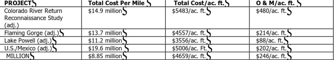
Total Cost41 Cost Adjustment Explanation ...43
Colorado River Return Reconnaissance Study vs. Million ...43
Additional Cost Estimate Support ...46
4. COST - BENEFIT ANALYSIS ... 48
I. Project Risk ... 48
Scope, Engineering, and Design ...48
Water Markets ...48
Meteorological ...49
Cost of Capital - Public/Private Comparative Effects ...50
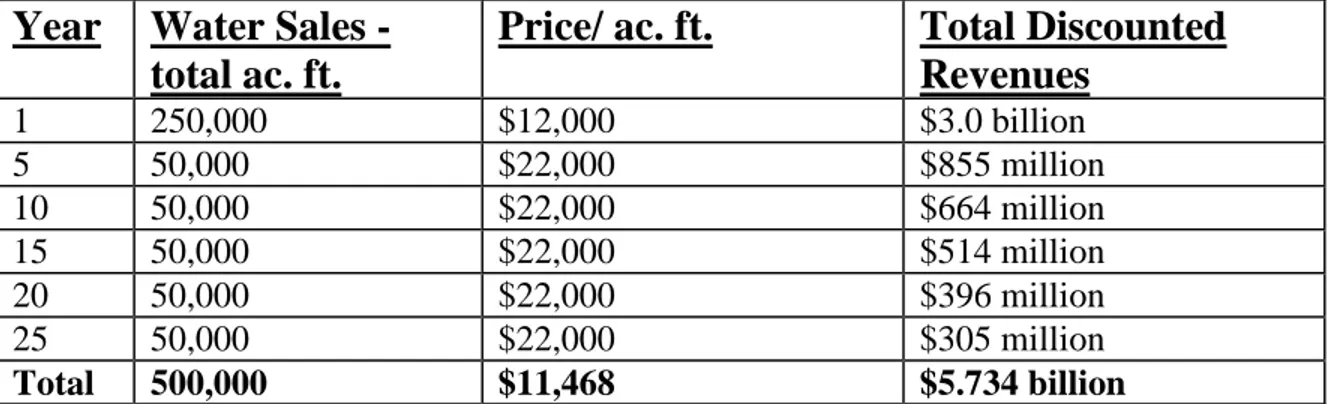
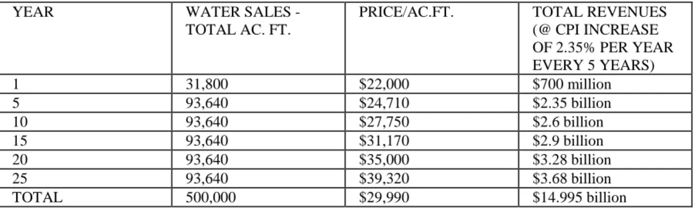
II. Net Returns51 Forward Contracting ...52
Present Value Sale ...53
Operational Costs ...54 5. FINAL RESULTS ... 57 I. Conclusion ... 60 REFERENCES ...63 v
LIST OF TABLES
3.1 Project Cost Estimate and Comparison... 42-43 3.2 Allocated Costs ... 47 4.1 Discounted Sales ... 53 4.2 Total Water Revenues ... 54 5.1 Summary of Results ... 57-58
CHAPTER ONE INTRODUCTION
Colorado Water Situation
The State of Colorado has a vibrant, growing economy. The Front Range of Colorado, an area directly east of the Rocky Mountains stretching from Fort Collins to Pueblo, has evolved into the major commercial, high technology, education and population center of the Rocky Mountain West. The State’s economy, once agricultural and mining–based, has a current population of over 5,000,000 people, and is expected to grow at a rate of approximately 1.1% per year, (State of Colorado, 2012). The area is expected to add an additional 3 million people by the year 2040, with the majority of that increase concentrated on Colorado’s Front Range.
Growth and economic change has put significant pressure on the existing water resources. The finite water supply is under pressure from an expanding array of uses that include recreation, in-stream flows, wildlife habitat, environmental mitigation, wetlands restoration, and a variety of other socially desired alternatives. The major water users, including numerous municipalities, farmers and industry, are sharing a water resource that is increasing in value as the system tightens and demand grows. There are policy issues related to a new statewide water plan, continued dry-up of irrigated farms as water moves to higher economic use in the urban setting, depleting aquifers affecting groundwater users, and the long-term un-resolved battle over moving additional water from western Colorado’s respective water surpluses to eastern Colorado demand centers.
It is in this context that innovative solutions to a growing water crisis are sought. The success or failure of those water supply solutions will influence both short- and long- term socio-economic opportunities in the State of Colorado and the region, as described by Gertner (2007).
Continued droughts over the last 10 years are influencing water supplies in the western United States, as pockets of drought have moved from Colorado to Texas to California. A lack of water storage, particularly in Colorado, leaves a water supply system that is less than resilient.
Roger Pulwarty, a climatologist at the National Oceanic and Atmospheric Administration, states his assessment.
Pulwarty is convinced that the economic impacts could be profound. The worst outcome, he suggested, would be mass migrations out of the region, along with bitter interstate court battles over the dwindling water supplies. But well before that, if too much water is siphoned from agriculture, farm towns and ranch towns will wither. Meanwhile,
Colorado’s largest industry, tourism, might collapse if river flows became a trickle during summertime. Already, warmer temperatures have brought on an outbreak of pine beetles that are destroying pine forests; Pulwarty wonders how many tourists will want to visit a state full of dead trees. (Gertner 2007)
Well before that, if too much water is siphoned from agriculture, farm towns and ranch towns will wither. Some areas in Colorado, such as those dependent on agricultural water rights in the Arkansas Valley, are reflecting the negative impacts from agricultural to urban use. Meanwhile, one of Colorado’s largest industries, tourism, might face challenges if river flows diverted for urban use begin to negatively impact rafting, fisheries, and water quality.
Water Development and Project History
The inter-basin transfer of water from Western Colorado to Eastern Colorado has occurred as the Front Range of Colorado has grown. These transfers have been the backbone of many of the state’s water resource projects. The historic purview of water development by agricultural, mining, and private interests has evolved and morphed as the increasingly large water projects became later funded and built by government entities. Denver Water, the largest and most well-known of the municipal districts, was originally started as a private water company. Denver Water still retains significant and very valuable water rights in western Colorado streams and reservoirs as a direct influence and benefit of Denver Water’s private sector beginnings.
The largest water project in the State of Colorado, the “Big Thompson” project, was proposed by both private and public interests. Authorized in 1937, it was built, owned, and is operated by the Bureau of Reclamation thru the Department of Interior. The project brings over 200,000 acre feet of water from Shadow Mountain and Granby reservoirs located west of the continental divide into the Big Thompson River system in the northern Front Range. The water rights, primarily developed for agricultural use, are now primarily held by and used for municipal interests.
Despite continued population growth and increased water demand, few additional water projects to bring water to the Front Range or move water more efficiently in the region, have been implemented since the Big Thompson Project. Once the purview of private water interests, these water project solutions in Colorado are now relied on and sourced from federal, state and municipal governments
Ag to Urban Transfer
The reallocation of water from irrigated farmland has been one of few alternatives available to meet growing municipal, industrial, and environmental demands. The current and future reallocation of water rights used for agriculture will affect several hundred thousand acres of irrigated farmland and has major economic implications for the State of Colorado with several billion dollars of economic losses predicted. In addition to the loss of this economic base, the reallocation has significant social, cultural, environmental, and aesthetic impacts. Much of the farmland affected by “agricultural dry-up” is the current focus of protection from local and regional land-use policies and master plans, policies that promote the protection of irrigated farms for agricultural production, wildlife habitat, and open space.
Demand, Policy, and Project Issues
The State of Colorado will need to make important water policy choices in order to accommodate the expanding needs of the public and balance the socio-economic benefits of the water resource. As water demand continues to increase for residential growth, rising water values may diminish opportunities for other socially desirable uses such as recreation, and ultimately limit the potential growth of the area. The recently completed Statewide Water Supply Initiative has projected a supply shortfall exceeding 500,000 acre feet of water over the next 40 years. In context, the state currently uses approximately 15 million acre feet from a combination of surface and groundwater supplies.
Water issues in the western U.S. can be extremely complex. The potential to satisfy legal, institutional, and political constraints are critical to the success of any project. Water laws, trans-basin and interstate restrictions, public policy, water markets, and other related issues either allow or dissuade new opportunities. Water projects often require mitigation of downstream impacts ranging from land-use to endangered species. There are typically major social, economic, political, and environmental constraints.
When considering the overall economic welfare of the region, government entities and municipalities have failed to plan and develop additional water resource projects of any significance. Part of the issue resides in water law constraints affecting the State of Colorado’s standing and inability to own water rights, except for special purposes, and municipalities, whose responsibilities include water supply development and delivery, are constrained by the competitive demand for water and few alternatives in a tightening water supply system. There are major external factors and costs associated with the development of new water supplies.
The State of Colorado’s proposal in 2004 to move water from the Colorado River main stem, known as the Colorado River Return Supply Project, was the last major attempt to fund and build a new water supply project. Conversely, the private sector, faced with externalities ranging from environmental, legal, financial, and political challenges, has not been successful in establishing sufficient aggregate coalitions or financing to develop and build a major water project.
Importance of the Study and Research Goals
This research will evaluate whether the provision of large, major water projects, which has been accomplished largely by public entities over the last century, can be satisfied with a private sector alternative. Substantial information for this research has been accomplished through the interview of individuals familiar with Colorado water law, trans-basin diversions, the Upper Colorado River Compact, United States Bureau of Reclamation water projects, Utah water resource alternatives, Wyoming water resource alternatives, environmental impact analyses, engineering firms, and a myriad of other information relevant to large water projects.
An evaluation of historical and current constraints can provide a background and analysis for the successful provision of a future water resource project. Although the private sector has historically been unable to deliver large, major water projects, policy changes and economic conditions may provide a "window of opportunity" for private sector development of a water resource that could benefit the State of Colorado from the Green River Basin. The idea for a water supply project from the Green River for use in Colorado has not been found in any current literature or research.
This cost-benefit analysis will research the constraints and advantages of a water project in the Green River Basin compared to the Colorado River Basin. This research will show that the successful completion of an alternative water project may minimize environmental impacts to the
respective river basins, minimize negative hydrological impacts, respect state sovereignty, allow joint management of the river system, provide a new water supply to enhance regional economic growth, and provide an alternative cost effective project that may be accomplished privately.
CHAPTER TWO
LITERATURE REVIEW AND BACKGROUND
Economic Theory of Water Water as an Economic Good
Water is clearly an economic good, but how it is defined, and the approaches to policy and resource management that reflect its’ uses, vary significantly. Water cannot be defined as a PURE public good, however, the assignment of property rights that differentiate between public and private goods can be problematic. As example, natural sources of water—rain, rivers, etc.— oftentimes make it non-excludable. (Dalhuisen, et. al., 1999)
Water is sometimes considered a “common pool resource” as a limited quantity must be shared across “a variety of uses and over geographic areas.” (Dalhuisen et. al., 1999: 5) Buckley et. al. comment on the management of common pool resources:
“[Common pool] resources are subject to problems such as congestion, overuse and potential destruction unless some form of common property management regime is enforced. Indeed common property resources are seen to be inefficient by economists as they provide incentives which can lead to socially sub-optimal outcomes. Specifically there is evidence of a variety of issues such as rent dissipation, high transactions costs, high enforcement costs and low productivity.”
Treated as a common pool resource rather than a private good, public policy has had a serious impact on water markets, and governments worldwide are actively involved in water production and management. (Dalhuisen, et. al., 2001) This is very true in the United States, where governments have built and managed water systems, regulate water use, and regulate the environmental impact of water usage.
However, Clifford Winston, Senior Fellow of Economics Studies at the Brookings Institution, (2007: 3) has argued that this may not be the best approach:
Before assessing public production it would be desirable to determine whether private production is feasible and, if so, whether it would generate greater net benefits to society than public production.
Ephraim Clark and Gerard Mondello (2002) argue that water often has the characteristics of a private good: “From an economic point of view, many of its characteristics would tend to put “water” in the private commodity category. Indeed, it can be infinitely divided, stored, privately owned, and sold on a market, etc.”
Public perception of water, particularly in Colorado, generally does not reflect its legal status as a private right. Water is oftentimes perceived to be a public good, provided and delivered exclusively by public entities. The general public has little knowledge of water law and the complex nature of water appropriation that has developed over the last 150 years. While irrigation districts, municipalities, private individuals, and special districts both develop and own water rights, the State of Colorado is not allowed to own water rights, with the exception of in-stream flows benefitting non-consumptive uses such as recreation and fisheries. This lack of knowledge can exacerbate the challenges associated with the perception of private development of water supplies. The State of Colorado’s inability to own water exacerbates its’ lack of standing to develop new supplies, relegating the State to a policy making institution without power.
Public/Private Water Provision
While the government has traditionally taken a major role in the provision of water, the State of Colorado would be an exception to this, due to the almost pure private right nature of Colorado water and the lack of any statewide policy. The World Bank (1993: 27-31), notes that “Given water's special characteristics, there are good reasons for governments to intervene, and even to directly manage various water uses by means of irrigation departments and water supply
authorities.” Someone must ultimately be accountable for the delivery of quality drinking water and water to grow crops to feed the population as water and food are very basic needs.
However, the World Bank (1993, pp.27-31) notes that governments “may not have done this job well”. The current situation in Colorado would confirm that this is the case. Lack of integrated policy, complex water laws, and intense competition for the resource with oftentimes inefficient markets, (Gertner 2007) has been problematic. Demand will in the future exceed supply and the government, to date, has not been effective in establishing policy, or in compensating for market failure in the provision of water.
Sun (2000) identifies with the problems in Colorado and elsewhere, “Problems are likely to be more severe when a water source involves various levels of government, such as central, provincial and local governments.” Municipalities are oftentimes responsible for acquiring, treating and distributing water within its jurisdiction. However, as discussed in the New York Times Magazine (Gertner 2007), municipalities have generally not shown an ability to build coalitions to address their water issues at a common level, so they must compete for existing resources. As a result, a wide range of entities, municipalities, agricultural interests, recreationists, and environmental concerns are competing for an increasingly scarce resource. Colorado government has not proven effective in addressing the increased demand for water and the need for new potential supplies along the Front Range.
Grigg (2002) states that bureaucratic and inefficient government agencies are also a source of government failure in irrigation water delivery.
“…the cost of water supplies, particularly the operation and maintenance costs, are often too high, while the service provided is generally poor. This creates a vicious cycle, in which high costs plus poor service lead to users' unwillingness to pay, causing inadequate funds for operating and maintaining the system, leading to a further decline in the level of service.”
Winston cites Wolf (1979), “The fundamental underlying problem… is that the existence of government failure suggests the absence of an incentive to reconcile an intervention’s costs and benefits to policymakers with its social costs and benefits. In contrast, it appears that at least in some instances market participants have greater incentives to correct market failures than the government has to correct these failures.”
It is in this context that private provision of water may be explored. While private ownership may still lead to monopoly conditions, public regulation may be effective in addressing these issues. Dalhuisen et.al. (1999: 14-17) states that while the water supply-chain, viewed as a whole, would be considered a natural monopoly because of the huge infrastructure investments required, when segmented, individual parts may not have monopoly characteristics. Private ownership would then provide motivation to properly care for the resource for its long term viability. He goes on to say that “there is hardly any discussion that the network used to transport water can be best provided and maintained by the government.” In this vein, much of Western Europe and many other countries have worked toward privatizing the water industry. (Dalhuisen, et. al. 2001) These issues, raise the question of whether the private sector can develop, transport and provide wholesale distribution of water while meeting diverse social welfare needs. As Winston notes above, it should be determined whether the private sector can satisfy such needs before concluding that government is the optimal provider.
Social Welfare in Managing the Water Resource
Water “is an essential element of the economic, environmental, aesthetic and social health of the state. The overall quality of life for all of the state’s residents—human, plant and animal—is inextricably linked to the quality and quantity of our water resources.” (Marcouiller, Coggins, 1999: 1)
While this quote reflects Wisconsin, which has relatively good water supplies, it is equally applicable to the situation in Colorado. Human demands for water are diverse: drinking water for
the sustenance of life, food production, recreation, environmental (protection of wildlife and habitats), energy, aesthetics. Even within these categories, there are diverse needs, with fishermen’s needs being quite different from those of water skiers, but both being classified as recreational. As noted by Marcouiller and Coggins (1999: 2), “Modern lifestyles promote the use of water more than in the past, placing tremendous pressure on limited resources. As a result we are forced to make choices with respect to how water will be used and who will use it.”
The uses of water are highly diverse but not always in conflict (e.g. water can be used for fishing in one part of a river, hydropower in another, agriculture in another and drinking water, via return water flows, once treated, from the same river). In the Western United States, however, water is limited and there is increasing conflict over a finite water supply that has major social welfare and economic benefits, and there is little argument that the water resources are adequate for the demands being made upon them.
In the Colorado Front Range, social welfare issues arise around water allocation in several areas:
• The extreme demand for this resource and inefficient markets provide limited motivation to consider the needs of future generations in the allocation and pricing of water.
• Misconceptions of water as a renewable resource in some cases, for example groundwater, such as the Denver Aquifer, which has been a traditional water resource for agricultural use and Front Range municipal use, has been significantly depleted. Slow to re-charge and non-renewable except over a multi-generational period, groundwater resources are oftentimes overused and available supplies not efficiently allocated for critical future needs.
• In Colorado, where farmers own rights to water that is needed for cities, the “willingness-to-pay” for municipalities is generally much greater than the economic benefits of agricultural production, resulting in the sale of water rights by farmers to the cities, and the loss of local agriculture. The incremental loss of the agricultural economy is a major policy and social welfare focus. Front Range agriculture has traditionally used 90% of the water in this geographic area (Gertner 2007).
The Western U.S. Context Colorado Water Law
The water rights of most western states are governed by the concept of 'prior appropriation', which requires the application of beneficial use in order to have a legal right to utilize water. The doctrine of prior appropriation contains three main premises-
1. To obtain a water right, water must be put to beneficial use;
2. The legal preference of water is - domestic, agricultural, and industrial;
3. Water rights are transferable as long as the transfer does not injure another user.
The doctrine of prior appropriation allows water users to benefit from the resource based on a system of seniority. Senior water rights are protected from impact from a junior water right diverting in a given water system, and senior water rights have significantly more value, in general, than junior rights filed at a later date. For example, senior water rights located downstream from junior water rights may prevent a junior user from diverting water even though the respective diversion may be upstream from the senior right. In times of short water supply, such as during a drought, a junior water right may lose any right to divert water.
The doctrine of prior appropriation not only affects in-state users of water, but also interstate water rights. In 1922, the U.S. Supreme Court ruled that the law of prior appropriations
applied regardless of state lines. Based on the Supreme Court ruling, a state like California could legally establish priority use of the Colorado River to the extreme disadvantage of the slower growing states, leaving those areas without a developable water resource.
The Colorado River Compact
Delph Carpenter, a Colorado attorney, proposed that the states sharing the Colorado River Basin negotiate a compact to determine individual states’ rights to the water. In 1922, delegates from the Colorado River Basin met to discuss and negotiate an interstate agreement that apportioned Colorado River Basin water use. Water from the Colorado River Basin is used by seven states in the western U.S. The Colorado River Basin states include Wyoming, Utah, Colorado, New Mexico, Arizona, Nevada, and California. The compact determined to divide the Colorado River into two basins, with the demarcation line set at Lees Ferry, located in northern Arizona, close to the Utah border. Wyoming, Colorado, Utah, New Mexico and a small portion of Arizona that diverted waters above Lees Ferry were designated the Upper Basin states, and California, the majority of Arizona, and Nevada, the Lower Basin states.
The compact provided for a management agreement of Colorado River Basin water supplies with an allocation provided to the respective Lower and Upper basin. The Upper Basin states were required to deliver 7.5 million acre-feet of water annually, plus an additionally contingent 1.0 million acre-feet, on average, to the Lower Basin states, with delivery measured at Lees Ferry during any consecutive ten-year period. The river flows historically are highly erratic, ranging from 4 million acre-feet to over 22 million acre-feet annually. The extended timeframe allowed the required delivery to be averaged over time to make up for years of low flow in the river system, providing reasonable flexibility to the Colorado River System between wet and dry years in order to accommodate the required delivery to the Lower Basin states.
Following congressional ratification of the Colorado River Compact, another agreement was signed between the Upper Basin states that determined the percentage of annual flows to which each state would be entitled. The Upper Basin states, unsure of total water availability after delivering 7.5 million acre feet to the Lower Basin, allocated the remaining water as percentages with Colorado receiving 51.75%, Utah receiving 23%, Wyoming receiving 14%, and New Mexico receiving 11.25%.
The Upper Basin states have historically experienced slower development compared to the Lower Basin. As a result, Utah, Wyoming, Colorado, and New Mexico, collectively, have not used their full allocation of Colorado River water. The states in the Lower Basin have been experiencing a more immediate need for water from the Colorado River Basin. Nevada, for example, anticipates that its compact allocation will be fully utilized by the end of 2015. One outcome of slower development in the Upper Basin states has been surplus flows to the Lower Basin. Those flows have, until recently, historically provided additional water and economic benefits to the Lower Basin states.
It is that surplus use and the future implications to the Colorado River Compact that has the Upper Basin states increasingly concerned about a legal challenge to the Compact itself. Underlying the concern about water resource needs in the entire region is the presence of a potential legal, policy, and institutional change that could negatively impact Upper Basin States' rights. Based on the Lower Basin’s historic use, a successful challenge to the Compact could potentially foreclose any options to utilize the Colorado River Basin as a future water resource, which would have major impacts throughout the four state Upper Basin region.
Water Policy in the West
Early water policy in the western U.S. has historically been described as serving the interests of agriculture and mining and the expansion of the western United States’ economic interests. The laws that govern water rights in most of the western states were formulated from those early policy goals. Policies were developed that enabled the protection of water rights for primary industries in deference to other uses. As mineral exploration dramatically increased in the late 1800's, large mining companies and their affiliated business interests began diverting waters for complex projects, including those for storage and/or out-of-basin transfers, known as trans-basin diversions.
Miners and agricultural interests historically had the economic incentives and opportunity to use the abundant water resource. Very early in the region's growth, private interests, rather than the public sector, were the primary catalysts for water development. Economic opportunities were created via the development of water rights for beneficial use and the sale of those water rights for profit. Individuals and business interests had incentives to pursue the economic exploitation of water as higher economic use provided market incentives for development and transfer. However, water laws developed constraints that precluded the hoarding and speculation of water. This prevented water rights from being held indefinitely without applying or putting the water to beneficial use and is known as the 'non-speculative doctrine'.
The recognition that an opportunity existed to 'prove up' water rights for low value uses and then transfer those rights to higher value uses was sufficient catalyst for private water development projects. However, as water demand began to grow, many private water development plans failed. The larger water projects required substantial capital and faced major external hurdles
including engineering and infrastructure complexities, which were oftentimes difficult to overcome, opening the opportunity for government intervention.
Public Water Projects
The U.S. Government began planning for the provision of water resources following the famous exploration of the Colorado River and Green River drainages by John Wesley Powell. Public policymakers recognized the extensive infrastructure and costs associated with water delivery systems. Both federal and state agencies began planning for the expansion of water diversions and storage, with the Army Corps of Engineers and the Bureau of Reclamation taking the lead in the development of water projects throughout the western U.S.
As the region grew, large government-planned and funded water projects enhanced agricultural and industrial production. The subsidized water infrastructure provided opportunities for growth that would have been difficult or impossible to achieve without governmental assistance. Many of the projects were designed to exclusively benefit agriculture, while other projects planned for other uses, including consumptive use for the growing towns and cities and non-consumptive use such as hydro power.
Although the federal government has been the major provider of water resources in the western U.S., no major federal water projects have been built in the region since the completion in the early 1960s of Utah's Lake Powell. Following the completion of Glen Canyon Dam in the 1960s, public sentiment began to mobilize toward evaluating water projects from public welfare perspectives other than economic. As downstream flows were altered, wildlife habitat destroyed or inundated, and significant archaeological and cultural opportunities foreclosed, the policies that protected water rights for the original beneficial uses of domestic, agriculture, and industry, began
being disputed by those with much broader and diverse social interests, particularly those focused on growing environmental benefits.
State of Colorado
One of the larger projects in the State of Colorado, planned in the early 1930’s and funded by the Bureau of Reclamation, was the Northern Colorado Water Conservancy District Project. The project developed a system of storage reservoirs, pipelines, and inter-basin diversions that provide water for irrigated lands and municipal use in a geographic region that stretches north of Denver to Fort Collins and east to Sterling, Colorado.
The Northern Colorado Water Conservancy District, providing what is known in the water business as 'Big T' water rights, instituted the flexibility to provide water for both agricultural and municipal uses. As Colorado's Front Range economy continues to expand, water rights that were once used for irrigating highly productive farms continue to be converted to municipal uses in order to accommodate residential growth. The majority of the approximate 200,000 acre feet of ‘Big T’ water once used for agriculture on an annual basis is now diverted to municipalities.
Projects such as the Northern Colorado Water Conservancy District, may eventually be allocated entirely for municipal use. The change of water uses from agricultural to municipal and recent legal rulings has expanded the role of water resources within the State of Colorado and other western states. Policy changes that promoted water use exclusively for agriculture and mining have been altered by institutional factors, including judicial rulings. The realignment of water policy reflecting environmental and other social welfare goals, and to a large degree, the end of government-sponsored and funded water projects.
Policy Changes
Supply constraints, increased demand, and drought have been and will continue to be a major catalyst for water policy change as water rights continue to increase in value. Recently, drought conditions in the western United States has focused the need to evaluate and develop water projects for the environmental, social, and economic welfare of the region as dry conditions have forced the evaluation of various alternatives to supplement water resources. Policy changes promoting conservation measures such as storage of water in empty gravel pits, reallocation of underground water rights, water banks, and other potential alternatives have been addressed. However, few supply-enhancing projects have been implemented.
Many policies are directed toward developing innovative water solutions that will support the expanded use of water resources, provide for conservation, and ensure the future social and economic welfare of the region. Attempts to approve funding for new water projects, allocation of financial resources to evaluate future projects such as the feasibility study for the Colorado River Return Reconnaissance project, and joint efforts by diverse coalitions, whose primary focus is the development of projects to protect the State from long-term drought conditions, have all been direct results of pressures generated from several dry years in the region. Diverse policy coalitions, which have historically been in conflict, are no longer focused on the use of water for one specific purpose over another. Agricultural interests have joined environmental interests to work toward finding common solutions to water resource issues.
Agriculture is the largest user of water resources in the West. Water conservancy districts, ditch and irrigation companies, and other agricultural-based consortiums are also experiencing changes through internal personnel changes and external coalitions that are altering historic bylaws or other restrictions for water use—restrictions which have favored agriculture--to include the use
of water for everything from municipal use to in-stream flows. Many of the irrigation boards now consist of individuals with natural resource backgrounds, not agricultural production backgrounds. This has prompted changes in water policy within these coalitions, oftentimes accelerating the removal of water rights from agriculture.
Pressures from stakeholders favoring changes to water policy include individuals within ditch companies, outside public policy institutions, and legal maneuvering to promote changes for economic gain. Those stakeholders have had cumulative effects regarding the expanded role of water resources. The coalitions are increasingly willing to promote additional flexibility for the use of waters within the state and the region. As uses expand, demand increases, the finite supply tightens, and water values increase.
Colorado Water Market
The value of water in the State of Colorado has increased dramatically over the last ten years. A major catalyst for the increase in water prices was policy change within Front Range municipalities regarding 'cash in lieu' rates. Cash in lieu rates are rates established by municipalities that reflect approximate water values. The estimated value of the water paid in cash to the municipality, rather than the actual water supplied. For example, a developer is generally required to provide one acre foot of water to municipalities for every residence built. As municipalities determined that water supplies were much more valuable and beneficial to their future interests, a majority of municipalities altered policies requiring developers to provide water rather than a cash payment. Without a “cash in lieu” option, builders and other users were forced to go into the open market and purchase water from whatever sources were available, oftentimes from irrigated farms.
The policies had a perverse effect. Water values tripled within a six to eight month period, causing many farms to be purchased exclusively for their water rights. Agricultural interests sold water rights for municipal use to the same municipalities that had policies favoring protection of irrigated farmland.
Increasing demands and limited supplies continue to pressure the water market with the current market price of water at approximately $36,000 per acre foot of actual delivery (hard yield) for 'Big T' water rights. ‘Big T’ is considered the benchmark for value in the Front Range of Colorado as it has a reasonably efficient and robust market with comparatively few external transaction costs.
Private Water Provision
The opportunity for a major private-sector water project may rest with recent water policy and economic changes. As the availability of water supplies tighten and demand increases, the water market may support an opportunity enabling private investment in major water infrastructure, an arena that has historically been the role of government. The private sector may now be able to successfully develop a large water project for the public welfare needs of the State of Colorado.
It is within this context—
• A significant long-term drought that limits water supplies,
• Steadily increasing domestic demand from a growing urban population,
• A continued expansion of industrial, recreational and environmental uses placing pressures on a finite water supply,
• And rising water prices created by that growing demand, which have also brought about policy changes
—that a large-scale water project planned, funded, and implemented by the private sector may be viable. That opportunity could alter historic policies that have relied on government provision for major water supply projects.
Colorado River Basin Systems Analysis The Colorado River
The Colorado River flows from its headwaters in Rocky Mountain National Park in a southwesterly direction, traversing high mountain valleys thru Glenwood Springs Canyon, then into West-Central Colorado at Grand Junction. Entering eastern Utah, the river flows into Arches and Canyonlands National Parks near Moab, Utah. The river then enters increasingly deep sandstone canyons at the confluence of the Green River, located southwest of Moab, Utah. The Colorado River continues flowing southwest through Cataract Canyon prior to being stored in Lake Powell, as shown in the following map.
Figure 2. 1
The Green River
The Green River flows from its headwaters in the Wind River Range northwest central Wyoming, transitioning south from the mountains thru the high desert country of southwest Wyoming. As it enters the northeastern corner of Utah, it is captured and stored in Flaming Gorge Reservoir, which is located along the Wyoming - Utah border. As waters are released from Flaming Gorge, the river begins to flow toward the east and enters the State of Colorado at Brown's Park. The river forms a horseshoe bend for approximately 40 miles and then exits back into Utah to the west, flowing through Dinosaur National Monument. The river then flows through Jensen,
Utah, into Green River, Utah, and then down to the confluence of the Colorado River in Canyonlands National Park.
Between Jensen, Utah and Green River, Utah is the area known as Desolation Canyon, which consists of sandstone canyons carved from the geologic formation known as the Green River shale formation. Two major tributaries flowing from Colorado enter the Green River. These include the Yampa River in Colorado and the White River below Jensen, Utah, both tributary to the Colorado River Basin.
Colorado Regional Analysis - The Colorado River
Within Colorado, the Colorado River serves a substantial infrastructure. Water rights are diverted to the Front Range of Colorado via trans-basin tunnels and canals, and numerous diversions are located in western Colorado for municipal, industrial, power, and agricultural use. Valuable ranchlands, residential communities, light industry, and tourist-related businesses occupy the lands bordering the river system. The geography consists of productive and expansive river bottoms and opportunities to divert water rights along most of the Colorado River corridor. As a result, a substantial portion of the water is diverted for beneficial use. Despite the extensive localized and regional uses, without a major dam on the river and the ability to store water, surplus water that belongs to the State of Colorado continues to flow to other users downstream such as California.
Lower Wyoming/Utah Regional Analysis - The Green River
The underutilized nature of the Green River Basin is in stark contrast to the Colorado River. The Green River Basin serves very few communities. The region along the Green River has a comparatively small agricultural base and economies consisting of mining, tourism and some small
industry. The Green River has few diversions for consumptive use due to the remote region, lack of major agricultural uses, and infrastructure.
Green River, Utah, a community of approximately 1,200 people, is the only town below Flaming Gorge Reservoir that relies on municipal water rights from the Green River. It also has the most valuable crops with a substantial portion used for melon production. The geography bordering the Green River consists primarily of small, open sandy bottoms, surrounded by sandstone and shale cliff formations. The Green River has two dam systems for storage, Fontenelle and Flaming Gorge, and one private dam that diverts water for irrigation and power above Green River, Utah. The dam at Green River, Utah was planned and built by Stewart B. Wilson and Samuel Wilson, forefathers of this author.
The Green River flows downstream to the confluence of the Colorado River, at which point the two rivers merge, with continued flows being stored by Lake Powell. The size of the two rivers and their respective annual water flows at the confluence of the Colorado River and Green River is similar. Over a 50-year period from 1952 - 2002, the Colorado River has averaged 2,266,328 cubic feet per second (approximately 4,532,656 acre feet) and the Green River has averaged 2,043,921 cubic feet per second (approximately 4,087,842 acre feet).
Regional Watershed
The majority of research for this study will focus on the Colorado River Basin System, specifically the relationships between the Colorado River main stem and the Green River main stem, both legal tributaries of the Colorado River Basin System. The study differentiates the Green River Basin and Colorado River Basin for comparative purposes only. Legally, and critically important, the two rivers are considered to be part of the Colorado River Basin System. Waters can be appropriated for use in Colorado on any body of water within the Colorado River Basin
System, despite its’ geographic location or State in which a diversion is located, as long as the diversion is located in one of the Upper Basin states of Colorado, New Mexico, Utah, or Wyoming.
A system of reservoirs known as the Colorado River Storage Project provides for the comprehensive development of water for the Upper Colorado River Basin. Its primary authorization is to assist with the development of water supplies for the Upper Basin states. The project also furnishes the longtime regulatory storage needed to permit states in the Upper Basin to meet their flow obligations to the Lower Basin States, measured at Lees Ferry, Arizona, as defined in the Colorado River Compact, and utilize their apportioned water.
The project includes four storage units: Lake Powell on the Colorado River in Utah, near the Utah/Arizona border; Flaming Gorge Reservoir on the Green River near the Utah and Wyoming border; Navajo Reservoir on the San Juan River near the New Mexico and Colorado border; and the Wayne N. Aspinall (Blue Mesa) storage units on the Gunnison River in West-central Colorado, which consists of three interconnected reservoirs. Combined, the reservoirs of the Colorado River Storage Project have a total capacity of approximately 34,000,000 acre-feet. Waters available for beneficial use located and authorized in the four reservoirs can be used in any of the four Upper Basin states, subject to respective compact allocations. The reservoirs do not have a geographical restriction. As example and important for this analysis, Flaming Gorge Reservoir, located in both Wyoming and Utah, cannot constrain Colorado and/or New Mexico from using its’ storage capacity or respective water supplies.
During periods of low stream flow, the stored water in the Upper Basin is released to meet flow obligations to the Lower Basin. Water use stored by the various projects of the Upper Basin include a portion for beneficial use, sediment and flood control, recreation development, and fish
and wildlife conservation. In addition, a significant amount of electricity is produced to meet the needs of the western U.S. region. A brief description of the four reservoirs follows:
Lake Powell
Lake Powell is located on the Colorado River in north-central Arizona and south-central Utah. Lake Powell is the second-largest reservoir in the country with a storage capacity of 27,000,000 acre-feet and extends 186 miles up the Colorado River. Lake Powell provides water storage for the Upper Basin and is used to meet flow obligations to the Lower Basin States at Lee's Ferry, Arizona. The dam generates electricity to provide revenue for the repayment of the project and Lower Basin states and provides electrical power generation.
Flaming Gorge
Flaming Gorge Dam is on the Green River in northeastern Utah about 32 miles downstream from the Utah-Wyoming border. The Flaming Gorge Reservoir has a total capacity of 3,788,900 acre-feet, and an active capacity of 3,515,700 acre-feet. The Flaming Gorge Reservoir is used to provide users of the Upper Basin to apportioned water, and generate electricity to provide revenue for the repayment of the project.
Navajo Reservoir
Navajo Reservoir is located on the San Juan River on the Colorado/New Mexico border in South-central Colorado. The reservoir is used by both Colorado and New Mexico for a variety of water related needs and has a total capacity of 1,700,000 acre feet.
Wayne N. Aspinall Unit - (Blue Mesa Reservoir)
The Blue Mesa Reservoir system is on the Gunnison River in west-central Colorado. The system consists of three separate, interconnected reservoirs. The system has a combined storage
capacity of 1,080,000 acre feet. Blue Mesa is used to provide agricultural and municipal water to Western Colorado in addition to generation of power for the region.
Water Projects Overview - The Colorado River and Green River Basins
Several studies have been completed or are in process on potential pipeline projects to deliver water from the Green River Basin or Colorado River Basin from the Colorado River main stem, Lake Powell or Flaming Gorge Reservoir. Studies include: Draft—Green River Pipeline, Cost Analysis, Utah Division of Water Resources, October 2002; addendum, draft, Green River pipeline, cost analysis, Utah Division of Water Resources, October, 2003; Lake Powell pipeline feasibility study, Washington County Water Conservancy District, Boyle Engineering Corp. and Alpha Engineering, Inc., March, 1995; Colorado River Return Reconnaissance Study, State of Colorado, Colorado Department of Natural Resources, Colorado Water Conservation Board, prepared by Boyle Engineering Corp., November 14, 2003; The Regional Colorado River Conveyance Feasibility Study, prepared by Boyle Engineering Corp., February 20, 2002. Also, a preliminary analysis has been undertaken by the State of Wyoming Water Resources Department to evaluate pumping water from Flaming Gorge Reservoir to the North Platte Basin in Wyoming.
The various studies include costs and potential routes for water pipelines that would deliver water to users in Utah, Colorado, and California/Mexico. All of the studies were based on preliminary reconnaissance to determine potential feasibility and general costs. Much like Colorado, both Utah and Wyoming are evaluating available options to supplement or expand water supplies.
The Utah studies include options to pump 100,000 acre feet of water from Lake Powell west to the St. George, Utah area and options to pump 60,000 acre feet of water from Flaming Gorge Reservoir west to the Weber River and users along the Wasatch Front, primarily the Salt
Lake City and Provo, Utah areas. The Flaming Gorge study, prepared by the Utah Department of Water Resources, considers moving water across Wyoming and Utah from the Flaming Gorge Reservoir facility. The Colorado River Return Reconnaissance Study considers three options of moving 250,000 acre-feet, 500,000 acre-feet, or 750,000 acre-feet, respectively, from the Colorado River main-stem at the Colorado-Utah border.
The Colorado River Return Reconnaissance Study, completed in November 2003, contains the most extensive and detailed information of all the comparative studies. Multiple routes and costs for infrastructure development, water quality mitigation, water temperature mitigation, environmental issues, and other significant problems are addressed. Project constraints include moving waters from the main stem of the Colorado River into a high mountain point of delivery near Leadville, Colorado, which maximizes delivery opportunities into three separate basins. The study, on a comparative basis, is the most useful for establishing base costs for an alternative project from the Green River Basin.
CHAPTER THREE
ENVIRONMENTAL, WATERSHED, AND COST COMPARISON
The Million-Green River Basin Water Project will evaluate and compare environmental issues, watershed issues, and costs to the Colorado River Return Reconnaissance Study, a comparable project with the same goal—to bring water to the Front Range of Colorado. Cost comparisons will also be analyzed with other water projects in the Southwest. This secondary information from comparable projects will be used to extrapolate values and approximate costs for the research study because the cost to obtain primary data specifically for an alternative project would be prohibitive. The reliance on secondary data for the comparative evaluation of an alternative water resource project should not significantly affect outcomes.
The Million-Green River Basin Water Project proposes to transfer water directly from the Green River, or alternately, from Flaming Gorge Reservoir, to multiple delivery points along the pipeline route. The point of diversion for the pipeline would begin in northeastern Utah or southwestern Wyoming and terminate along the Front Range of Colorado.
The Colorado River Return Reconnaissance Study proposes to transfer water from the Colorado River to multiple delivery points throughout Colorado. The point of diversion would begin in west-central Colorado at the Colorado/Utah border and terminate in central Colorado, with a single delivery point serving three river basins (see figure 3.1).
Figure 3. 1
Environmental Comparison
It is important to recognize that environmental issues and impacts may prevent any respective water project from occurring, regardless of other issues. An evaluation based first on environmental constraints is critical to recognize the probable opportunities for success. The largest single constraint to any water project is environmental issues related to point of diversion impacts, downstream impacts, water quality, and species habitat. Both projects propose the movement of water from west of the Continental divide to east of the Continental divide.
The Colorado River Return Reconnaissance Study has major water quality issues as well as several environmental issues that must be overcome if the project is to be constructed. Environmental impacts include a diversion point directly in the habitat of both the endangered humpback chub and pike minnow. Indirect environmental impacts include requirements to build expansive settling ponds to deal with water quality issues. The Colorado River main stem at the Colorado/Utah State line, which is the proposed point of diversion for the 'Big Straw' study, as its’
Flaming Gorge Storage Colorado River Green River Watershed Delivery North Platte Poudre Western Colorado South Platte Arkansas Point of Diversion 30
commonly known, is oftentimes described as "too thick to drink, too thin to plow". The river at that point carries significant silt loads that turn the river a muddy brown color. Only at very low flow periods in the late fall does the Colorado River become clear. The Colorado River below Grand Junction at the proposed diversion point has a high salinity content and a water temperature that is 20° warmer than the water temperature in the high mountain reservoirs and lakes where waters would be delivered.
Project consultants indicate that the water quality issues related to the Colorado River Return Reconnaissance Study, combined with endangered species habitat within the diversion location, provided significant obstacles to the project. The Colorado River Return Reconnaissance Study project has three significant water quality issues that must be overcome with a variety of water treatment methods in order to deliver water from the Colorado River at the Colorado/Utah border to the point of delivery. These water quality issues affect project feasibility.
• Silt content mitigation would require approximately 20 square miles of settling ponds.
• Salinity content would need to be treated using a reverse osmosis system.
• Water temperature reduction would require a system of chillers to reduce water temperatures as waters are being moved through the proposed pipeline.
Although water quality mitigation could occur through substantial and expensive treatments, secondary environmental impacts as a result of those treatments are likely, which would substantially increase costs. Negative environmental outcomes may result from the settling ponds and reverse osmosis system requirements.
The Colorado River at the Colorado/Utah border has substantial stretches of habitat protecting the endangered humpback chub and pike minnow. Environmental impact studies
indicate that decreasing the river flow in the Colorado River by only 120,000 acre-feet, which is below economic threshold for the project, significantly threatens the endangered species in the river system. One opportunity for effective mitigation may be a major dam built to store water and provide releases to offset diversions.
One possible existing reservoir that could be utilized to offset project diversions is located on a tributary of the Colorado River. The Wayne N. Aspinall Reservoir System, also known as Blue Mesa Reservoir, has a capacity of approximately 1,020,000 acre-feet, and is located on the Gunnison River. Downstream use on the Gunnison below the dam affects several thousand acres of irrigated farmland and several municipalities. Releases on the Gunnison River made to offset a diversion on the Colorado River may have negative secondary impacts.
The passage of the Endangered Species Act has dramatically reduced the probability of building any major new dam project, particularly in sensitive locations. The study indicated need for a low level, off-main stem dam, required to store and pump water, and presents another major obstacle to the project. The diversion point for the Colorado River Return Reconnaissance Study is located within a National Conservation Area, which may preclude opportunities to pump without extensive mitigation efforts. If flow and water quality issues could be adequately addressed, the location of endangered species in the river system may require other extraordinary measures in order for a project to proceed. For example, the 'takings clause' of the Endangered Species Act, which prevents the “taking” of a threatened or endangered species, could be instituted if it were found that the larval stages of any endangered or threatened fish species were being pumped into the intake and transported through the pipeline.
Comparatively, the Million-Green River project proposes a point of diversion in Flaming Gorge Reservoir, or just north of the reservoir on the Green River main-stem. Water quality is
excellent. Delivered water would have similar quality characteristics and aquatic ecosystems compared to the region where delivery would occur and no water quality mitigation is anticipated. A major advantage is the lack of endangered or threatened species habitat at the proposed points of diversion in or above the reservoir.
An Environmental Impact Study on the Green River from Flaming Gorge Reservoir to the confluence of the Green River and Colorado River below Moab, Utah has been recently completed. The EIS study identified changes to the Green River system that would better protect and enhance the habitat of the three endangered or threatened fish species in the river thru releases from Flaming Gorge Reservoir. These include the Razorback Sucker, the Pike Minnow, and the Humpback Chub. The EIS Study recommends flow changes that more closely approximate historic river flows prior to the building of Flaming Gorge Reservoir, which include higher spring peak flows followed by lower river flow once spring runoff has eased. Flaming Gorge Reservoir, since it's completion in the 1960's, has caused artificially high river levels via the sustained release of storage rights. The extensive capacity of Flaming Gorge Reservoir at approximately 3.7 million acre-feet allows for flow mitigation and management opportunities for endangered species and downstream users on the Green River, while balancing the recreational needs at the reservoir.
In addition, cold waters released from the bottom of the reservoir, currently at 50° to 55°, are negatively impacting threatened and endangered species habitat in the Green River below the confluence of the Yampa River and the Green River. A slightly warmer water temperature, setting a goal of 64°, would be more ideal for fisheries located downstream from the Green River/Yampa River confluence. Using a select withdrawal structure, water may be taken from Flaming Gorge at different reservoir levels in order to optimize water temperatures. A pipeline project removing
colder waters from Flaming Gorge Reservoir or directly from the Green River may assist in achieving the goals of the Environmental Impact statement and enhance the river environment. In summary, the Colorado River Return Reconnaissance Study recognizes diversions from the Colorado River would likely have significant environmental impacts on two endangered species. This issue alone might render the project unfeasible given environmental regulations. Mitigation of other issues, such as water temperature and water quality, would also be costly, and silting ponds and a reverse osmosis system, as well as a pipeline along the Colorado River, could add to the considerable negative environmental impact.
There are no endangered species in the immediate area of the diversion of the Million-Green River project and the impact on habitats would be less significant with this project. River flow management of the Green River, utilizing the large capacity of Flaming Gorge Reservoir, provides a major comparative advantage for the Million-Green River Basin Water Project.
Watershed Comparison
The point of diversion for the Colorado River Return Reconnaissance Study was chosen to minimize impacts on downstream users within the State of Colorado. Regionally, there are irrigated lands in Utah that depend on river flows from the Colorado River, in addition to potential economic impacts to recreation and tourism in Moab, Utah. Similarly, there are irrigated lands utilizing waters from the Green River at Jensen and Green River, Utah. Comparatively Moab, Utah has a larger economic base compared to Jensen and Green River, Utah, combined. The entire river system provides significant economic benefits to the State of Utah and parts of Colorado from recreation and tourism. Potential negative and positive impacts to the economies of both Utah and Colorado as a result of flow reductions to either river should be carefully evaluated.
Secondary watershed impacts can also occur from the routing of a potential pipeline project. The Colorado River Return Reconnaissance Study identified three potential pipeline routes. The central corridor, which begins west of Grand Junction, Colorado and ends at Leadville, Colorado, was identified as the preferred route. The central corridor has a routing along the Colorado River and Interstate 70 or, as an alternative, routing over Grand Mesa to the south. The route would transect south of Glenwood Canyon, through Eagle and the Vail - Beaver Creek area, before merging at a point of delivery near Leadville, Colorado. The Colorado River Return Reconnaissance Study project, given the routing along the Colorado River, may have additional negative impacts associated with watersheds near the Colorado River and irrigated lands in the same area.
The Million - Green River Project will traverse the I-80 corridor thru Wyoming. The corridor is designated a National Energy Corridor and has significant pipeline infrastructure. The pipeline project will divert southeast near Laramie, Wyoming and then follow existing pipeline and transmission corridors along the Front Range of Colorado. Few terrestrial impacts are anticipated.
Precipitation
The catalyst for the State of Colorado initiating the study of the Colorado River Return Reconnaissance Project was the 2002 drought in the region. The project may produce other consequences to the watershed and river system that were not addressed in the original report. An extended drought in the State of Colorado could multiply project impacts to the Colorado River main stem system within the State of Colorado and downstream in Utah, the same system where the diversion is located. Dry conditions in Colorado would increase demand for water at a time when less water would be available in the Colorado River main stem. Even if storage were built
at the Utah - Colorado state line, during a dry year the demand for water from the Colorado River could have a multiplier effect that would increase strains on the system.
In contrast, the Million–Green River Basin Project may provide the opportunity for broader, regional watershed management, reducing the overall impact on either basin. Primary precipitation for the Green River Basin is located approximately 450 miles north of the Colorado River Basin. As a result, while one basin may be facing drought, the other basin may have adequate, or even excess, precipitation, producing surplus river flows. For example, if the region within the State of Colorado were dry, at certain times the Green River Basin could be utilized to meet demand with surplus river flows, if available, or the extensive storage capacity of Flaming Gorge Reservoir could supply the needed water.
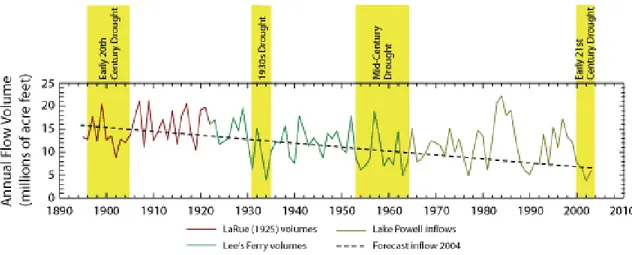
Joint supply management of the Green River Basin and the Colorado River Basin has the opportunity to maximize storage, use, and precipitation options on a much larger, regional basis, thereby conserving the water resource. An analysis of historic water flows on the Green and Colorado Rivers has been accomplished. The evaluation of river flows for the Green River subtracted total flows for the Yampa River and White River, which are tributary to the Green River, but originate in the Colorado River Basin.
The analysis showed that the 50 year average river flow of the Colorado River measured at the Colorado/Utah state line is 2,266,338 cubic feet per second, or 4,532,656 acre feet. The 50 year average river flow of the Green River measured at Green River, Utah is 2,043,921 cubic feet per second or 4,087,842 acre feet. Our study has calculated that approximately 25% of the time when the Colorado River is below average, the Green River exceeds its average flows by at least 20%, or 308,600 cubic feet per second. Conversely, when the Green River is below average, approximately 25% of the time the Colorado River exceeds its average flows by at least 20%, or
488,300 cubic feet per second. The offsetting surplus river flows provide opportunities for supply exchanges and increase water management opportunities.
The positive impact of this opportunity should not be overlooked. The Colorado River Return Reconnaissance Study potentially exacerbates water problems by moving water from an area impacted by the same shortage. Increased efficiencies, reduced economic impacts, reduced environmental impacts, reduced watershed impacts, and conservation of the resource base are the results of managing the Colorado River Basin and Green River Basin jointly rather than severally. Increasing the opportunities for supply management is a major advantage to the Million-Green River Basin Water Project.
Land Use
Land use along the respective project routes and the impacts from those routes differ considerably. A significant portion of the Colorado River Return Reconnaissance Study pipeline would be routed through valuable lands, particularly areas from Eagle to Vail, Colorado or Carbondale to Basalt, Colorado, and then to Leadville. Major challenges and costs will have to be absorbed in order to provide sufficient easement agreements for pipeline routing. Comparatively, the Million-Green River Basin Water Project primarily traverses low-value federal lands, including a significant portion controlled by the Bureau of Land Management. Overall, land-use values are significantly less along the routing for the Million-Green River Basin Water Project.
Water Delivery
The Colorado River Return Reconnaissance Study identified an approximate point of delivery at Leadville, Colorado. That delivery point allows the flexibility to deliver waters to the Arkansas River Basin, the South Platte River Basin, and the Eagle River Basin, which then flows into western Colorado. However, no major storage is available at that location or along that route.
Comparatively, the Million-Green River Basin Water Project could deliver waters directly into the Front Range region along various points. Existing storage facilities are available near Laramie, Wyoming and in the Front Range of Colorado. Comparative advantages of the Million-Green River Basin Water Project are significant for both expanded watershed deliveries and available storage facilities.
Cost Comparison
This section will compare costs for the Colorado River Return Reconnaissance Study and the Million-Green River Basin Water Project. The Colorado River Return Reconnaissance Study was selected for comparison because it is considered to be most comparable to the Million-Green River Basin Water Project in scope and goals. Project costs for the Colorado River Return Reconnaissance Study are taken directly from the study documentation. Project costs for the Million-Green River Basin Water Project were estimated using the Colorado River Return Reconnaissance Study as a reference point, then adjusting based on four water pipeline feasibility studies and industry averages.
The central corridor of the Colorado River Return Reconnaissance Study is identified in the study as the preferred route and is used for this analysis. The Study considered annual water deliveries of 250,000 acre feet, 500,000 acre feet, and 750,000 acre feet. The analysis will use the Study’s costs for 500,000 acre feet of delivered water to estimate construction costs because this