Scienpress Ltd, 2018
Geopolitics of the Tigris and Euphrates Basins
Nadhir Al-Ansari1, Nasrat Adamo1, Sven Knutsson1 and Jan Laue1Abstract
Euphrates and Tigris Rivers are the longest Rivers in southwest Asia. The main utilizers of the water of these rivers and tributaries are Turkey, Syria, Iran and Iraq. The two rivers rise in Turkey, which makes it the riparian hegemon. Some of the tributaries of the Tigris and Shat Al-Arab Rivers rise in Iran, which makes it the riparian hegemon for these rivers. Iraq and Syria are the lower countries in the basin and for this reason, they always to ensure the quantity of water required to satisfy their requirements. All these countries are in the Middle East, which characterized by its shortage of water resources. Since the 1970s conflict between riparian counties were noticed due to population growth rates, food security, energy needs, economic and technological development, political fragmentation, international water laws, water and management availability and public awareness. These caused tensions, which sometimes escalated to the verge of war. To solve this conflict a mediator is required that has the capability to bring all countries concerned to the negotiation table. Syria and Iraq are to give Turkey and Iran some incentives to cooperate. Furthermore, all counties are to adopt prudent strategic plan based on comprehensive resources development to ensure good water management and minimum water loses and waste. This due to the fact that modeling studies of the future suggest that water shortage problem will intensify. Keywords: Euphrates River, Tigris River, Turkey, Syria, Iran, Iraq
1 Introduction
The amount of water on earth is 1.4 billion cubic kilometers (UN, 1976) and the annual fresh water required for human being use is about 1000 cubic meters annually (Gleick, P., 1996). About 97% of the available water is saline oceanic water and 77% of the remainder is stored as ice, and 22% as groundwater and soil moisture, while 0.35% in lakes and marshes. The water within the atmosphere is
1
0.04%, then there are only 0.01% fresh water supplies in rivers (White, 1976) which provide 80% for human beings on the earth and, therefore rivers carry 0.003% of all the water available on earth (Elhance, 1999). In The 80 countries of the Third World that support 40% of the world`s population suffer however, from water shortage problem which has become a daily life fact. These countries suffer from shortage of personal and household needs. Consequently, 1.2 billion people are suffering physically from water shortage and 1.8 billion lack adequate sanitation (Elhance, 1999). Furthermore, in the Third World, about 80% of illnesses and 30% of unnatural deaths are due to water disease and polluted water (Elhance, 1999). Future predictions suggest that there will be 37 countries in 2025 having shortage of water for all needs (Biswas, A.K., 1991). For these reasons, most of the countries of the world try to utilize as much as they can of the water of their rivers to fulfill their demand.
More than 60% of the river basins in the world are shared between more than one sovereign state (Biswas, A.K., 1993). These basins are distributed as follow: 57 in Africa, 35 in North and South America, 40 in Asia and 48 in Europe (Elhance, 1999). They cover 47% of the total land mass on the earth which includes 65% of Asia, 60% of Africa and 60% of South America. Due to the importance of water use and distribution between countries sharing the basins, 300 treaties were signed and more than 3000 treaties include provisions relating to water. Despite these facts, coordinated and integrated management of international river basins is still rare (Elhance, 1999).
In the Third World there are number of international river basins that are shared by more than one state. This number is more than 165 river basins (UN, 2003). In such basins, there is always a dominant regional power and in the case of Tigris –Euphrates basin, Turkey, is the dominant power (Elhance, 1999).
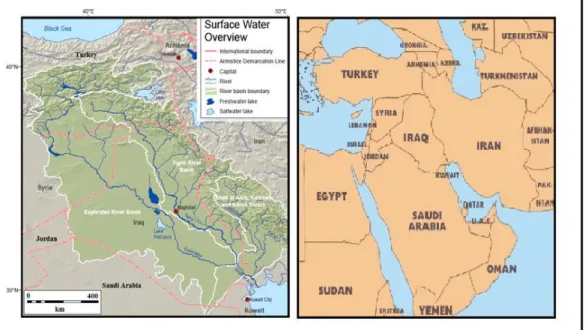
The Middle East is well known by its water shortage problems. The average annual rainfall does not exceed 166mm/y (Biswass, 1994; Roger and Lydon, 1995; Allan, 2001; Al-Ansari, 1998, 2013, 2016). Water allocation per capita does not exceed 500m3 in 12 countries (Cherfane and Kim, 2012; Barr et.al., 2012). In view of these facts, water resources are very essential to life, socioeconomic development, and political stability in this region. In this work, the conflicting issues on water resources of the Tigris and Euphrates Rivers basins (Figure 1) discussed and possible solutions to resolve these issues are given.
2 Geography of Tigris and Euphrates Basins
Euphrates River represents the longest river in southwest Asia followed by the Tigris River. Both rivers originate in southeast Turkey and some of the Tigris tributaries originate in Iran (Figure 1). The Euphrates length is about 1,178km in Turkey then it enters Syria and runs about 604km to reach the Iraqi border where it runs 1,160 km toward the south. In Turkey, two tributaries join 45 km northwest
of the city of Elazig to form the Euphrates. The first is Karasu and the second is Muratsu. The Euphrates River flows through Taurus Mountains and then reaches the Syrian border at Karkamis. Inside Syria three tributaries join the river (Sabor, Belaikh and Khabor). In Iraq, no tributary joins the river. Down south at Qurna city, the left channel of the Euphrates meets the Tigris River forming Shatt Al- Arab River and the other joins Shat Al-Arab further downstream. This river runs about 132km until it reaches the gulf. Few tributaries that originate from the Zagros Mountain range in Iran join Shatt Al-Arab. The main tributaries is known as Karun which joins the main river about 32 km downstream Basrah City. The river forms the border between Iraq and Iran for a short distance.
Figure 1: Tigris and Euphrates Rivers Basins (modified from ESCWA, 2013).
The Euphrates River catchment area in Turkey is about 125000 km2 (28.2%), while it is only 7600 km2 (17.1%) in Syria and the remainder 177000 km2 (39.9%) is in Iraq. It should be mentioned however, that part of the catchment of the river lies in Saudi Arabia (66000 km2), but it does not contribute any water to the river accept when precipitation takes place in that area which is very rare.
High discharges of the Euphrates River takes place usually during March-June period where about 63% of the annual flow passes through that period. The minimum flow period is July and August. During flood time, the river carries huge amount of sediments (Al-Ansari et.al., 1988). Elhance (1999) stated that generally the amount of sediments that is carried by the Euphrates in one day can cover an area of 600 acres with a layer 0.25 cm thick. This in fact how the Mesopotamian plain was formed.
southwest Asia. Its drainage area is 235,000km2 distributed between 4 countries as follow: Turkey (17%), Syria (2%), Iran (29%) and Iraq (52%) (Figure 1). The river rises near lake Hazar in southeast Turkey. It runs toward the Turkish-Syrian border and forms the border between these countries for about 45 km, then it enters Iraq 4 km north Fieshkhabur near Zakha city. During its course in Iraq 5 main tributaries join the main river. These are Khabur, Greater Zab, Lesser Zab, Adhaim and Diyala (Figure 1). Most of these tributaries rise from Zagros mountain range. They carry snow melt and rainfall and for this reason, depending on the phasing of these two types of flows, the flow varies greatly within the Tigris. The sediments transported by the river at Baghdad varies with the discharge from 35 to 52 million tons per year (Al-Ansari and Toma, 1986; Al-Ansari and Ali, 1986).
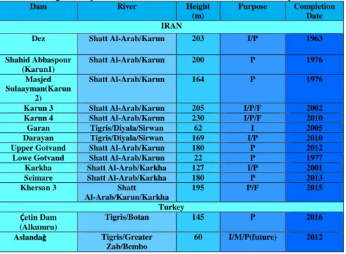
Flow records show great variation of the flow of the Tigris and Euphrates rivers. The flow of the former can fluctuate where the high flow can be eighty times its low flow while the latter can be twenty times its low flow (Elhance, 1999). The implications of these variations led all riparian countries to build as many dams as they could to overcome these variations and to ensure availability of water (Table 1). One of such projects, which raised tension, is the Greater Anatolia Project (GAP), which includes 22 dams (14 on the Euphrates and 8 on the Tigris) and 19 hydropower stations (Ali, 2018).
The confluence of the Tigris and Euphrates Rivers at Qurna city forms Shat Al-Arab River. The catchment of this river shared between Iraq and Iran. The main tributary of this river is Karun, which rises in Iran. Iran tries to secure its interest in Karun and Shatt Al- Arab. Recently, Iran diverted all the waters of the tributaries including Karun inside its borders (Abdullah, 2012).
Table 1: Dams on Tigris, Euphrates Rivers and Tributaries (source Wikipedia, 2017 a, b, c).
Dam River Height
(m)
Purpose Completion Date IRAN
Dez Shatt Al-Arab/Karun 203 I/P 1963
Shahid Abbaspour (Karun1) Shatt Al-Arab/Karun 200 P 1976 Masjed Sulaayman(Karun 2) Shatt Al-Arab/Karun 164 P 1976
Karun 3 Shatt Al-Arab/Karun 205 I/P/F 2002 Karun 4 Shatt Al-Arab/Karun 230 I/P/F 2010 Garan Tigris/Diyala/Sirwan 62 I 2005 Darayan Tigris/Diyala/Sirwan 169 I/P 2010 Upper Gotvand Shatt Al-Arab/Karun 180 P 2012 Lowe Gotvand Shatt Al-Arab/Karun 22 P 1977 Karkha Shatt Al-Arab/Karkha 127 I/P 2001 Seimare Shatt Al-Arab/Karkha 180 P 2013 Khersan 3 Shatt Al-Arab/Karun/Karkha 195 P/F 2015 Turkey Ḉetin Dam (Alkumru) Tigris/Botan 145 P 2016 Aslandaḡ Tigris/Greater Zab/Bembo 60 I/M/P(future) 2012
Beyyurdu Tigris/Greater Zab/Bembo
48 I/M/P (future) Under Construction Atatṻrk (Karababa) Euphrates 169 P 1992 Balli Tigris/Khabour /Hezil/Ortasu 49 I/M/P Under Construction Batman Tigris/Batman 74 I/P 1999 Beyhan I Euphrates/Murat 97 P 2015 Beyhan II Euphrates/Murat 62 P Planned
Birecik Euphrates 62.5 I/P 2001
Burḉ Bendi Euphrates/Gṏksu 47 P 2010 Cizre Tigris/Botan 46 I/P Planned Ḉoukurca Tigris/Greater
Zab/Gṻzedlere
45.5 W/M Under Construction Dumluka Euphrates/Bugur 30 I 1991 Erkenek Euphrates/Adiyaman - p Operational
Gṏksu Euphrates/Gṏksu 52 I 1991 Hecihider Euphrates/Sehir 42 I 1989
Hancaḡiz Euphrates/- - I 1988
Ilisu Tigris 135 I/P/F 2017
Upperkalekṏy Euphrates/Murat 137.5 P 2017 Lower kalekṏy Euphrates/Murat 115 P Planned
Karakaya Euphrates 158 P 1987 Karkamiṣ Euphrates 21.1 P 2000 Kavsaktepe Tigris/Khabour /Hezil/Ortasu 66 W/M Under Construction Kayacik Euphrates/Sajur 45 I/P 2005
Keban Euphrates 207 P 1974
Kirazlik Euphrates/Botan 60 I/P 2011 Kralkizi Tigris/Maden 113 I/P 1997 Musatatepe Tigris/Khabour
/Hezil/Ortasu
34.5 W/M Under Construction Silope Tigris/Khabour /Hezil 79.5 W/M/P 2012 Silvan Tigris/Batman 174.5 I/P 2017 Sirrntiṣ Tigris /Birimşe 92 I 2013
Ṣirnak Tigris/Khabour /Hezil/Ortasu 56.8 W/M 2012 Uludere Tigris/Khabour /Hezil/Ortasu 55.5 W/M Under Construction Syria Baath Euphrates 14 P, I, F 1988 Tabaqa Euphrates 60 P, I 1975 Tishrine Euphrates 40 P 1999
Upper Khabour Khabour I 1992
F: Flood Control I: Irrigation M: Military P: Power W: Water supply
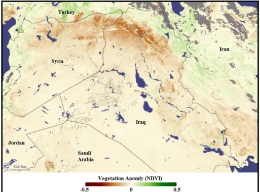
In addition to the above fact, climate change in the last few decades highly affected the region. Droughts affected Syria and Iraq (Figure 2) (NASA, 2009; Gleick, 2014; Stokes, 2016; Al-Ansari, 2013, 2016). Historical flow records for the period 1938 to 1973 indicate that the Euphrates River mean annual flow was 30 BCM at Jarablus, Syria. After this period dams were constructed and the flow started to decrease to 25.1 and 22.8 BCM for the periods 1974 to 1998 and 1990 to 2010 respectively (ESCWA, 2013). Similarly, the Tigris flow at Mosul for the
period 1931 to 1973 was 21.3 BCM and it dropped to 19.1 BCM for the period 1985 to 2005 (ESCWA, 2013). The overall long term flow is decreasing indicating a declining trend of 0.14 × 10⁹ m3/year for the Tigris and 0.19 × 10⁹ m3/year for the Euphrates (Figures 3and 4) (Abdullah, 2016).
Figure 2: Drought within Tigris and Euphrates basins (Modified from NASA, 2009).
Figure 3: A: The Euphrates average monthly flow at Thi-Qar station during the periods 1950–1980 (pre-dams) and 1982–1997 (post dams).B: The average daily discharge of the Tigris River upstream of the Shatt al-Arab (near Qurna city) before and after the development in the basin (Modified after
Figure 4: Long-term flow of Tigris and Euphrates Rivers (modified Abdullah, 2016)
3 Causes of the Conflict:
3.1 Water Availability
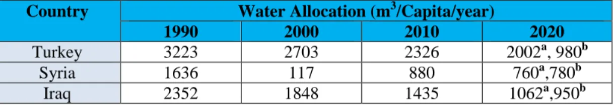
Different figures are published for the water allocation per capita per year (Tables 2 and 3). The figures given do not include restoring of the marshes in Iraq and it ignore the situation when GAP project is fully operating. Irrespective of the numbers given, Turkey claims that the allocations of water per capita in Iraq and Syria are sufficient to fulfill the requirements of people in these countries (Altinbilek, 2004).
Table 2: Water allocation per capita per year in Turkey, Syria and Iraq (source of data a- Bilen, 2000;b- Turkish Ministry of Foreign Affairs ,2012).
Country Water Allocation (m3/Capita/year)
1990 2000 2010 2020
Turkey 3223 2703 2326 2002a, 980b
Syria 1636 117 880 760a,780b
Iraq 2352 1848 1435 1062a,950b
The flow of the two main rivers is decreasing with time (Figures 2, 3 and 4). This is mainly due to the construction of dams in the upper parts of the catchment areas of the Tigris and Euphrates and climate change (Al-Ansari et.al.,2014a, b; Osman et.al., 2017a, b, c; Al-Ansari, 2013, 2016; IPCC, 2007). Surface and groundwater resources will be decreased with time (Voss et.al, 2013; Chenoweth et.al 2011; Bazzaz, 1993). Future predictions suggest lower precipitation accompanied with higher temperatures (Al-Ansari et.al., 2014d). Serious consequences are expected where (as an example, 71% of the water of the Euphrates River is from precipitation in Turkey), (UNDP, 2011). This condition will lead to more evaporation and drought periods (UNEP, 2011, Hameed et al., 2018). UN (2010) report indicated that these conditions will eventually lead to the dryness of the Tigris and Euphrates Rivers by 2040. In addition, all riparian
countries within the catchments of the two rivers will be most water stressed by 2040 (Maddocks et al., 2015).
3.2 Population growth rate and food security
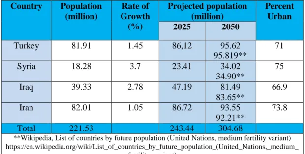
Population growth rates are relatively high in the Middle East particularly Syria and Iraq (Drake, 2007). Historically, the area (Arab countries only) was populated with about 20 million inhabitants in 1750 and the number in 1996 is 286 million (Drake, 2007). As far as the four main countries that lie within the Tigris and Euphrates basins (Turkey, Iran, Syria and Iraq) their total population is 221.53 million inhabitants (Worldmeter, 2018a, b, c, d). This number will increase by about 10% in 2025 and about 37% in 2050 (Table 3). Accordingly, the allocation of water per capita will decrease too (Abumoghli ,2015). The allocation within the Tigris and Euphrates basins is about 975.3 m3/yr/capita now (Table 3) and this will drop to 887.6 and 709.2 m3/yr/capita in 2025 and 2050 respectively. It is noteworthy to mention that there are other references which gives different figures but the outcome is the same where there will be decrease in water allocations with time.
Table 3: Population Characteristics within Tigris-Euphrates Basins (modified from Worldmeter, 2018a, b, c, d and Drake, 2007)
Country Population (million) Rate of Growth (%) Projected population (million) Percent Urban 2025 2050 Turkey 81.91 1.45 86,12 95.62 95.819** 71 Syria 18.28 3.7 23.41 34.02 34.90** 75 Iraq 39.33 2.78 47.19 81.49 83.65** 66.9 Iran 82.01 1.05 86.72 93.55 92.21** 73.8 Total 221.53 243.44 304.68
**Wikipedia, List of countries by future population (United Nations, medium fertility variant) https://en.wikipedia.org/wiki/List_of_countries_by_future_population_(United_Nations,_medium_
fertility_variant)
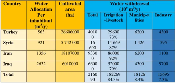
Governments in the Middle East try to attain food self-sufficiency and for this reason, the largest consumer for water is agriculture where it accounts for 66% of the demand (Hiniker, 1999; Allan, 2001). Countries within the Tigris and Euphrates basin allocate as an average 84.3% of the water consumption for agricultural purposes (Table 4). Iran has the maximum water allocation (92%) While Turkey (73%) has relatively the minimum water allocation for agriculture (FAO, 2008a, b, c, d). Thorough consideration of agriculture is required to objectively analyzed and
adequately address the water shortage problem (Sadik and Barghouti,1995). However, this is not the case where countries have unrealistic aspirations of food self-sufficiency and which would require a most fundamental change in national outlook and water management (Charrier and Curtin, 2007). Future challenges are so severe in meeting the increasing demands for water and are beyond the capabilities of individual countries (Sadik and Barghouti, 1995). Turkey is trying to convert the area of the GAP into a breadbasket and this threaten the irrigation based agricultural potential of the lower riparian Syria and Iraq (Hillel, 1994). Iraq and Syria used to be grain exporters and now they are importers and their capability to produce grains is less than Turkey (Hillel, 1994). Syria tried long time ago to achieve food self-sufficiency and to increase its irrigational areas, drip irrigation was used. As a result, wheat yield decreased by 50% and much of the livestock had died due to water scarcity and this caused many people to join insurgents so that they can survive (New York Times, 2013). Iraq tried to increase its agricultural lands and become grain exporter again by 2017 (United Nations and World Bank ,2003; Al Ansary, K. ,2015). Numerous projects were executed but salinity and water logging created serious problems for agricultural activities. After the second Gulf war, Iraq is importing its food reflecting disastrous agricultural conditions (Robertson, C. ,2009; Cockburn, P. ,2009). Recently, food security and self-sufficiency are not a major concern in both Iraq and Syria where national security problems especially the threat of ISIS is the priority now.
Table 4: Water use in countries within Tigris and Euphrates basins according FAO, 2008a, b, c, d and 2009 a, b, c . Country Water Allocation Per inhabitant (m3/y) Cultivated area (ha) Water withdrawal (106 m3/y) Total Irrigation +livestock Municip-a lities Industry Turkey 563 26606000 4010 0 29600 73% 6200 4300 Syria 921 5 742 000 16 690 14 669 87% 1 426 595 Iran 1356 18107000 9330 0 86000 92% 6200 1100 Iraq 2632 6010000 6600 0 52000 79% 4300 9700 Total 2160 90 182269 84.3% 18126 8.4% 15695 7.3% 3.3 Energy Requirements
Iraq is oil exporting country since the beginning of the twentieth century, while Syria started to export oil in 2001and Turkey has no oil reserves (Akanda et.al., 2007). For this reason, Turkey is trying to reduce its dependence on oil imports as an energy source. To achieve this goal, Turkey is trying to use hydroelectric power
to cover as much as 40% of the required energy (Turan, 2004). The GAP project is one of the strategies used so that Turkey can reduce 28 million tons of its oil imports when this project is fully operational (Bagis, 1989).
Syria and partially Iraq rely on hydropower to generate electricity. Despite the fact that Syria is oil producer but it relies on hydropower to generate electricity. This fact gives the opportunity for Turkey to decrease the flow of the Euphrates through the GAP project and threaten Syria although the. Turkish Government declared several times that the GAP is purely a development project. Some people believe that there are number of internal and external goals involved within the implementation of the GAP project (Waterbury, 1993; Alsowdani, 2005; Shams, 2006; Alnajaf News net, 2009; National Defense Magazine, 2009).
3.4 Water Management:
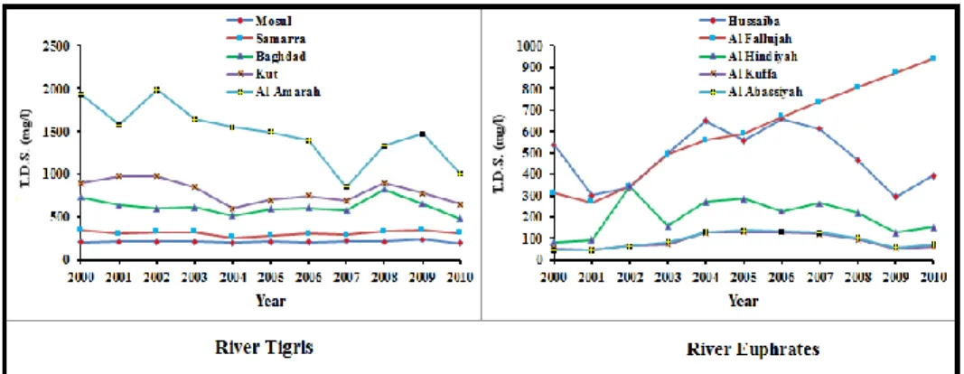
Poor water management strategies have exacerbated the water scarcity problems within riparian countries (Abumoghli, 2015). Water is wasted through old irrigation techniques where flood irrigation is still the dominant method used. In addition, the irrigation canals are unlined and /or uncovered which enhance water losses. Water quality of the rivers are deteriorating due to the extensive use of chemical fertilizers and pesticide. Back flow from irrigated areas and dumping of municipal and industrial waste in the rivers is accelerating the pollution of these river. Recent data for the period 2000 to 2010 collected by the Consulting Engineering Bureau at Baghdad University (CEB) (2011a) show the steady increase of the salinity in both rivers (Figure 5). Similar trend was noticed by ESCWA (2013) for long term salinity trend in both rivers. TDS is about 300 ppm at Ataturk Dam on the Euphrates, and it increases to 600 ppm at the Syrian-Iraqi borders which is already higher that the recommended level for irrigation and it increases to more than 1200 ppm (minimum) downstream at Samawah (World Bank, 2006; Iraqi Ministry of Municipalities and Public Work -IMMPW, 2011). As far as the salinity within the Tigris River, it increases dramatically downstream Baghdad due to intensive irrigation. To overcome the salinity problem in Iraq, a main outfall drain (MOD) was constructed south of Baghdad to the Gulf for a distance of 565 km to carry drainage water from irrigation projects from 150000 km2 with a discharge capacity of 210 m3/s (UNEP, 2003; Shahin, 2007). To overcome salinization and water logging, huge networks and sub-surface tile drains and surface drainage canals were constructed to collect drainage water from agricultural fields to be dumped in MOD (FAO, 2003, Taylor and Francis Group, 2003). Taking all these measures, recent estimates indicates that 4% of irrigated areas are severely saline, 50% are of medium salinity and 20% are slightly saline (CEB, 2011b). Salinity increase in conjunction with decrease of flow downstream along the courses of the two rivers has overstressed the agricultural sector in the southern Iraq. This situation causes dissatisfaction and frustration and creates irritation that might lead to conflict.
Figure 5: Salinity variation along the Tigris and Euphrates Rivers for the period 2000-2010 (sources of data CEB ,2011a)
3.5 Economic Development:
The Middle East is going through a development stage which caused the movement of about 50% of the population from rural to urban areas. Such movement aggravates the water shortage problem where water consumption increased about 10 to 12 times its normal per capita as village dwellers (Drake, 2007). Furthermore, the relative fast increase in oil prices caused rapid economic developments and raised the standard of living in Iraq and Syria (Abumoghli, 2015), although the economy of both countries are hardly affected by corruption and the struggle with ISIS in the past few years. The two countries raised their need for water in view of these developments. Adding the claimed needs for Turkey, Syria and Iraq it sum up to 149% of the total water available (Akanda et.al., 2007). Since Turkey is not an oil producing country, it is trying to use its water as a commodity for bargaining where the president of Turkey in 1992 declared at Ataturk dam opening ceremony that “Neither Syria nor Iraq can lay claim to Turkey's rivers any more than Ankara could claim their oil… The water resources are Turkey’s; the oil resources are theirs. We don't say we share their oil resources, and they can't say they share our water resources” (Reed, 2005). Furthermore, Turkey proposed Peace Pipeline and Manavgat River project focus to trade water with Mediterranean and Middle East neighbors (Kolars, 1994; Martin and Kerids, 2003).
3.6 Technological Development:
The riparian countries had built several dams on the Tigris and Euphrates Rivers and are planning to build more dams. The Middle East well known with its high temperatures and the construction of these dams have increased the quantity of evaporation from the surface water of the reservoirs. Furthermore, agricultural practices still not modernized where old irrigation methods are still used. Such practices are also leading to high quantities of water losses. Syria tried to use new technologies in irrigation practices and it faced plenty of problems (Varela-Ortega and Sagardoy, 2003; Friedman, 2013). One of the main problems that farmers were not educated and could not understand and apply the new technologies.
3.7 Political Fragmentation:
Middle East was dominated by the rule of Ottman Empire since the thirteenth century till its defeat and dissolution during World War I. Then the area was divided into different countries but Britain and France ruled them. During these periods conflict among different people dampened. After that people ethnic consciousness increased which lead to growing disparities and rivalries in the region and all the people became more competitive and nationalistic. The tension and friction between the United States of America and the Soviet Union and their allies during what is known as the “Cold War” had a restraining effect on the likelihood of major conflicts, and this does not exist now.
Excessive use of surface water and groundwater and water pollution became a source of friction and tension. There are examples that reflects this fact like the 1967 war between Israel and Arab states where water was one of the underlying causes as well as the Israeli occupation of Lebanon in 1982 where they occupied Litany River and diverted its water. To meet the high water demand, Israel is extracting 40% of its water rom aquifers beneath the West Bank and Gaza (Drake, 2007). Plenty of dams were built on the Tigris and Euphrates Rivers and their tributaries (Table 1). Unilateral decisions without any consultation with riparian countries also raised friction (Abdullah, 2012). As an example the tension between Syria and Iraq in 1974 over the Euphrates water sharing. Future prediction models for surface water and groundwater resources show their depleting in the Middle East (Bazzaz, 1995; Al-Ansari et.al., 1999, 2011, 2012; Chenoweth et.al., 2011; Voss et.al. 2013; ESCWA, 2013; Hamdy, 2013). For these reasons, UN Secretary General Boutros Boutros-Ghali said in 1985 that the next war in the Near East would not be about politics, but over water (Venter, 2008).
3.8 International Water Laws:
The International Law Commission of the UN worked on the Convention on the Law of the Non-Navigational Uses of International Watercourses for three decades and it was approved by the United Nations General Assembly on the 8th July, 1997. Three countries voted against this law. These countries were: Turkey, China and Burundi (Elhance, 1999). This convention needs however to be ratified by thirty-five countries in order to enter into force, which it had not attained hitherto. In this law, the UN stated rights and obligations that states should follow. It also gave the principals and mechanisms that states should follow to avoid dispute escalating to the level of acute conflicts. This law might be suitable for non-arid regions and not for arid region like the Middle East (Al-Ansari, 2016). In addition, despite the principals stated, there is no legally binding international obligations for countries to share their water (Morris, 1992). Having this situation, then agreements will depend upon several factors like: the goodwill of the countries involved within the drainage basin, degree of national interest and the power (both internal and external) available for the country to pursue its politics (Jones, M., 1995).
3.9 Public Awareness:
Despite the fact that Syria and Iraq are facing water shortage problems now, it is expected that all countries within Tigris and Euphrates basin will experience the same situation in future. This is due to increase of population and development in these countries. This implies required improving the efficiency of current water supply and usage needs to achieve secure and sustainable water for future generations. To achieve such goal, all parties concerned are to be involved (Schaap and Steenbergen, 2002).
An overall strategy and designing a public water awareness program is to be adopted which includes promotional activities, implementing the activities and monitoring and evaluating their effectiveness. Al-Ansari (2016) suggested educating politicians and policy makers; water planners and managers; and social marketers and educators about the importance of water conservation in the potable water supply sector and how it may be approached, so that they can take part in national water awareness program and promoting it to society as a whole. Special curricula in schools is to be designed by developing and finding ways to introduce the subject and the media should raise awareness about the importance of water issues. Farmers are to be educated on the use of new irrigation techniques that are suitable for arid regions since the agricultural sector is the highest consumer of water resources. Using non-conventional water resources should be considered seriously. The public should understand the importance of proper water management. The ignorance of the impact of political and economic decisions of the long term guarantee of water resources are one of the biggest problems in the Middle East (Al-Ansari 2016).
Texas Water Development Board (2010) set a program for water conservation and use it can be adopted by the countries concerned. The main points in this program can be summarized as follow:
What are the rules and regulations for water and wastewater permits?
How is the water produced and distributed?
How is the wastewater collected and treated?
How does your utility provide maintenance and repair services?
What kind of customer service does your utility provide?
What conservation measures are in place?
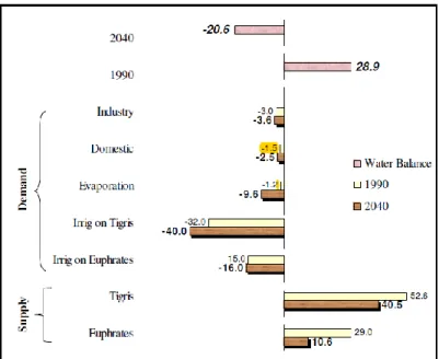
As an example it is noteworthy to mention that Iraq is expected to have -20.6 billion cubic meters in 2040 (Figure 6) ( MacQuarrie, P., 2004). Such a figure raises the alarm and action should be taken starting now.
Figure 6: Iraqi Water Balance 1990, 2040 (bcm) ( MacQuarrie, 2004).
4 International Agreements
4.1 Historical Background
Turkey, Iran, Syria and Iraq are the main riparian countries within the Tigris and Euphrates basins. Since Syria and Iraq are the downstream countries within the basin, so they are always trying to ensure the required amount of water that can meet their domestic, agricultural and industrial demands. In addition, they consider that these basins as international “watercourses” which should be treated as an integrated entity by all the riparian users. On the other hand, Turkey considers the Euphrates and Tigris Rivers as “trans-boundary Rivers” which is under its exclusive sovereignty until it flows across the border and when it joins the Tigris River to form Shatt Al-Arab River then it becomes an international river. In addition, Turkey is one of only three countries that voted against the International Law Commission of the United Nation on the law of Non-Navigational Uses of International Watercourses in 1997. Turkey also consider this is not legally binding because the convention does not apply to them (Gruen, 2000). Furthermore, Tigris and Euphrates Rivers basins are considered as one basin by Turkey due to the fact that they join together to form Shatt Al-Arab River, in addition to mass water transfer between the Tigris and Euphrates Rivers via the Tharthar system, while Syria and Iraq consider them as two separate basins.
Historically, the Tigris and Euphrates basins were under unitary authority of different empires and colonies (Elhance, 1999). Water issues disputes that took nationalistic character started after the British and French mandates were dissolved. Before World War II, the first signed treaty was in 1913 between Britain, Russia, Iran and Turkey for the regulation of Shat Al-Arab River. France as the mandatory
power for Syria and Great Britain the mandatory power for Iraq signed a treaty in 1920 and they agreed to establish a committee to examine and coordinate the use of the Euphrates and Tigris Rivers (Berardinucci, 2010; ESCWA, 2013). This was followed by two treaties in 1921 where it states in article 12 that Aleppo city can use the water of the Euphrates River. Then in 1923, another treaty was signed between Allied powers and Turkey known as Lausanne agreement concerning the Euphrates and Kuviek Rivers. The treaty also included a provision that Turkey must consult Iraq before undertaking any hydraulic works (article 109) (Berardinucci, 2010; ESCWA, 2013). In 1926, Turkey and Allied powers signed a Neighborly Relations treaty where they agreed to cooperate together to use the Euphrates basin. The commission on the demarcation of the Turko-Syrian Frontier on the Tigris was established in 1930. As a result, a treaty was signed between Turkey and France (Syria) which stated that the border between the two countries is to follow the thalweg principle, establishing the border in the middle of the Tigris, regardless of shifts in the river’s course (ESCWA, 2013).
In 1932, the Iraqi Kingdome was announced and established. Then in 1937, Iran and Iraq signed a treaty. This was for demarcating their border and regulating navigation in Shat Al-Arab River. Now all the aforementioned treaties has much importance for contemporary interstate relations and geopolitics in the basins (Elhance, 1999, ESCWA, 2013). In the 1946, Ankara Treaty of Friendship and Good Neighborliness was signed by Turkey and Iraq (Beschorner, 1993) and is considered as the first legal instrument of cooperation where they agreed that Turkey shall install and operate permanent flow measurement facilities and inform Iraq periodically about the recorded data (article 3) and water infrastructure projects (Berardinucci, 2010; ESCWA, 2013). Turkey promised that it would not alter the Euphrates flow without informing Iraq, and, to adapt any future works to the needs of both states. In that treaty, Iraq was allowed to construct protection and observation posts in Turkey’s territory to prevent downriver flooding (Fadel et al., 2002).
First few hydrological projects began in Iraq in the 1950s where Samarra barrage and Dukan Derbendikhan dams were constructed in Iraq (Kibaroglu, 2008; Berardinucci, 2010). The first meeting between Turkey, Syria and Iraq took place in 1965 where it was decided to demise and end of the treaty system (Bari, 1977). New phase of their relationship took place between the three riparian countries in 1960s when Turkey decided to construct Keban Dam. Turkish and Iraqi experts held a meeting in June, 1964 and in that meeting, Turkey agreed to maintain a minimum discharge of 350 m3 /sec immediately downstream from the dam, provided that the natural flow of the river was adequate to supply this discharge. Establishment of a Joint Technical Committee (JTC) was proposed by Turkey. This committee is to inspect each river to determine its average annual discharge and to determine the irrigation needs of the three countries through joint field studies. Then it should prepare a statement of the main principles and procedures in order to facilitate an agreement on water rights (Kibaroglu and Scheumman, 2011).
Syria and Turkey demanded 18, 13, 14 BCM respectively of the Euphrates water annually. This amount exceeds the low annual flow of the Euphrates River. In these meetings, proposed dams were discussed in particular Keban (Turkey) and Tabaqa (Syria) Dams. After 22 rounds of talks, it came to a standstill (Daoudy, 2009). One of the main issues that was proposed by Turkey is that it agree to sign a tripartite treaty only if there was an “inclusive agreement on the distribution of the waters of all the rivers common to it and Syria” (Lowi, 1995). Later, Keban Dam was operating in 1973 and Tabaqa Dam in 1974. This raised very high tension between Iraq and Syria. The latter promised Iraq for a supply of 200MCM from Tabaqa Dam. The tension between Iraq and Syria became very high again in 1975 when Syria started to impound Assad Lake which deprived Iraq of some of its promised water share where it claimed that it did not receive half of its normal flow from Turkey (Berardinucci, 2010). The Arab League, Saudi Arabia and Egypt tried to mediate and solve the problem but all their efforts failed and both countries amassed troops along their border in June, 1975. Later, Saudi Arabia proposed sharing the water of the Euphrates on a basis proportional to how much water Syria receives from Turkey and this eased the situation but they did not sign any agreement. Turkey expanded the Lower Euphrates Project and its name became Güneydogu Anadolu Projesi GAP), the Southeastern Anatolia Development Project (GAP) in 1977 (Kibaroglu, 2008).
A protocol for technical and economic cooperation was signed between Iraq and Turkey in 1980 and Syria signed the protocol in 1983. Issues of regional waters – particularly the Euphrates and Tigris Rivers- were to be discussed by a joint technical committee (JTC). Later, Syria allowed Kurdish and Armenian rebels attacking GAP projects to have their headquarter in Syria. These rebels were conducting subversive actions on the GAP projects works (Zawahri, 2006) while Iraq allowed Turkey to attack the Kurdistan Worker’s Party (PKK) on Iraqi soil. In 1987, a protocol on Economic Cooperation was signed between Syria and Turkey. In that protocol, Article 6 reads as follows: “During the filling up period of the Atatürk Dam reservoir and until the final allocation of the waters of Euphrates among the three riparian countries, the Turkish side undertakes to release a yearly average of more than 500 m3/sec at the Turkish-Syrian borders and in cases when monthly flow falls below the level of 500 m3/sec, the Turkish side agrees to make up the difference during the following month”. In addition, Article 7 of the protocol states that Syria and Turkey shall work together with Iraq to allocate Euphrates and Tigris water within the shortest possible time frame. Article 9 asserts the intention of the two states to construct and jointly operate irrigation and hydropower projects on the two rivers (Zawahri, 2006; ESCWA, 2013). Then Syria and Iraq agreed that 58% of the Euphrates River water coming from Turkey would be released to Iraq by Syria (Schmandt et al., 2016). Due to the fact that Iraq was ignored and was not asked to sign that protocol, it did not allow Turkey to attack the PKK in Iraq and in 1988, Iraq suppressed its Kurdish uprising in February 1988, 60,000 Kurds fled to Turkey, further deteriorating their relationship (Beschorner, 2008).
going to impound Ataturk Dam`s reservoir. It explained the technical reasons behind the action and also provided a detailed program for the replenishment of the losses. In addition, delegations were sent to the region to explain the need for the action, and the measures taken. Impounding started on the 13th January, 1990 and ended to February 13, 1990. January was chosen because the demand for water is low in that month. Official complaints against this action were registered by Iraq and Syria and called for a new agreement to share the waters of the Euphrates River. They also agreed that 58% of the Euphrates water that Syria receives would be provided to Iraq (Kibaroglu and Scheumman, 2008). Iraq and Syria protested against the construction of Birecik Dam in Turkey which raised friction and tension again in 1996(Kibaroglu and Scheumman, 2008). In view of this situation, Iraq and Syria organized a joint water coordination committee to face water shortage problems. They agreed that Tigris and Euphrates water can be used in an equitable, reasonable sharing and utilization. To resolve the conflict, Turkey asked Syria in May, 1996 to engage in talks and it suggested that water can be divided according to the area of cultivated lands while Syria asked for equal share (Wolf, and Newton, 2008), consequently no agreement was reached. Syria continued to support the Kurdish rebel group (the PKK) to attack southeastern Turkey from Syrian soil. Turkey retaliated to this act in October, 1998 and asked Syria to stop supporting terrorists immediately, which was understood as a threat of military intervention. Syria responded to Turkey and they signed what is known as the Adana Accord. Accordingly, the relationship between the two countries improved and they signed another agreement in 2001 between GAP’s Regional Development Administration (GAP RDA) and General organization for Land Development (GOLD) (Berardinucci, 2010).
In 2002, Syria and Iraq signed an agreement which allows the former to establish a pumping station on the Tigris River. Project area and volume of water extracted was specified in that agreement (ESCWA, 2013). Later in 2007, Turkey and Syria reactivated the JTC and held a series of meetings during which they agreed to share information on meteorological patterns and water quality. The amount of water that Turkey released to Syria and Iraq was effected by the drought that was experienced in the region through the period 2007-2009. In 2009, Turkey and Syria signed a new agreement known as “Strategic Cooperation Council Agreement” and number of MoUs were signed. All the signed agreements focused on emphasis on improvements to water quality, the construction of water pumping stations (on the Syrian stretch of the Tigris) and joint dams, as well as the development of joint water policies (ESCWA, 2013). Turkey assisted Iraq through that period with additional water but they did not sign any agreement (Jones, 2009). Some of the tributaries of the Tigris rises in Iran and as far as Shat Al-Arab, is concerned, the two main riparian countries are Iraq and Iran. In this context, the first agreement was signed in 1913 which is known as the Constantinople accord concerning borders delineation between the two countries which dealt with continuous shifting of the river watercourse. This was followed by another agreement in 1937 signed with support from the League of Nations. According to
these agreements, Iraq has the full sovereignty over the two banks of Shat Al-Arab River although Iran kept claiming half of the river to its sovereignty. Iran supported the Kurdish rebels in north of Iraq during the 1970s so that it can exert pressure on Iraq to negotiate the Shatt Al-Arab status. In 1975, an agreement was signed in Algeria between the two countries. As a consequence, Iraq to conceded its right in half the Shatt Al-Arab and the Kurdish rebellion was ended (US Department of State, 1978). Iraq felt that it was humiliated and continuous strain started to increase till the war started between Iraq and Iran in 1980. The war ended without resolving the problem of Shat Al-Arab (Wallas, 1998). Till now, all Iraqi governments kept the strong position that Iraq would never reinstate the 1975 agreement.
The improved relationship between the two countries after 2003, had led the Foreign Ministers of the two countries to meet and discussed among other things the Shatt Al-Arab issue in 2014. Both parties agreed to move forward and work on the marking of land borders and to implement agreements in accordance with the borders treaty, protocols and agreements that were signed between the two countries in 1975 (Dinar Advice Guru, 2014). This is very important because Iran has done several things that effected the water resources situation in Iraq (Abdullah, 2012) which can be summarized as follow:
Dam was built on Wand River in 1960 and as a result Khanaqeen city was cut from its water resource. Three more diverting dams were built on the same river later.
Diverting Serwan River waters which is one of the tributaries of Diyala River.
Dams were built on valleys near the border with Iraq to divert the water inside Iran.
Building dams on Karkha River.
Water projects on Karun River and diverting its water inside Iran. These acts caused considerable hardship to the Iraqi population in general and to the inhabitants of border areas in particular; such as Khanqeen, Mandli, Badra and Jassan and lately to Qalaa-Diza, Halabja, and Shir-Zur in Iraqi Kurdistan Region.
4.2 International Law and Water Sharing Issues
Disputes concerning water resources of the Tigris and Euphrates Rivers between riparian countries seriously started in the 1970s when some of the riparian countries started to build dams on these rivers and the effect of droughts that dominated the region. Each country has its own justifications and explanations to the laws concerned which are the International Water Law, the Helsinki Rules (ILA Helsinki Rules, 1967), Berlin Rules (ILA Berlin, 2004) and the UN convention on the law of the None Navigational uses of International Water Courses (UN, General Assembly, 1997). These laws are based on restricting the territorial sovereignty of any riparian state to the part of an international fresh water system that is located on its territory, and the riparian State has to respect the right of the other riparian States
to utilize the system.
In addition, they approache the problem through the theory of community interest, and the theory of limited sovereignty to reflect the interdependent character of freshwater systems. In view of these theories, two provisions are to be considered. These are the doctrine of equitable utilization implying fairness and reasonable use and the rule of causing no harm. Therefore, riparian states should recognize the limitation imposed by the hydrological cycle (i.e. planned amount of water withdrawal from freshwater system does not exceed the amount it receives through the hydrological cycle) and the water should be capable of regeneration to the hydrological cycle (i.e. not polluted) (Bremer, 2013).
Syria and Iraq claim that Turkey is having water more than it needs and they would like to have more water to secure the water demand for their uses. Turkey claims that this is not correct because out of 180 BCM of the annual runoff, only 110BCM of water is usable and 25.9 BCM can be made available. These figures are based on considering technological, topographical and geological reasons and this makes this resource unavailable sometimes (Tomanbay; 2000 Yuksel; 2015 and Oei and Siehlow, 2016). When allocation of water per capita is considered (Table 4), it should be noted that these figures will change due to population growth rates (Table 3) and effect of climate change.
Historic rights for the use of the water of the River Euphrates were claimed by Syria and Iraq. The Turkish response was rejecting these claims where according to Helsinki rules; Articles I and V (ILA Helsinki, 1967) acquired rights can only be considered if it is based on equitable use for socioeconomic, geopolitical and hydrological factors, in addition to the avoidance of unnecessary waste in the utilization of waters of the basin. Furthermore, Turkey always accuses Syria and Iraq for using old irrigation techniques and wasteful water management procedures. Turkey suggested a three stage plan for the technical talks of the three riparian countries to solve the water allocation problems (Centre for Strategic Research, 1996).
Allocations and determining the demands for each country are to be based on: 1) assessment of available water resources 2) conducting inventory studies of available land resources and 3) improving irrigation practices to determine their economic viability. This plan was based on two premises. These are to consider the Tigris and Euphrates Rivers as one transboundary water course and secondly is that water requirements are to be based on scientific studies of the needs of that country. Iraq and Syria rejected this plan where they considered it as being vague and gives advantages to Turkey and fringes on the sovereignty of the riparian states. In addition, Turkey considers the two rivers form one basin and deficiency of water in the Euphrates can be avoided by transferring water from the Tigris to the Euphrates via Tharthar canal. Iraq rejects this idea and consider the two rivers in geographically separate basins. In any case, this idea of single basin is not valid any more after the construction of Ilisu Dam and the effect of drought due to climate change which has been experienced recently.
defined in article X of the Helsinki Rules (ILA Helsinki, 1967), and article 16 of the Berlin Rules (ILA Berlin, 2004) in addition to article 7 of Part II of the UN convention on the law of the None Navigational uses of International Water Courses (UN General Assembly, 1997). This claim is based on the fact that Turkey is reducing the share of other riparian countries by implementing the extensive GAP project. This is damaging the agricultural practices both in Iraq and Syria as well as municipal water and health sectors. Therefore, the project has negative influences on the people and the environment where the quality of water is deteriorating. It is noteworthy to mention that Iraq is the most negatively affected country due to impounding of dams both in Turkey, Iran and Syria as well as water quality deterioration.
Finally, it should be stated that Syria and Iraq with the occupation of ISIS parts of these countries, the water issue is not considered as a priority now in view of the present situation.
4 Discussion
Countries in the Middle East suffer from water shortage problem. This has caused tension and friction and sometimes escalated leading to war between countries in the region. The Tigris and Euphrates Rivers are considered as a very valuable source of water for the riparian countries within the basins of these rivers. Four main countries (Turkey, Syria, Iran and Iraq) utilize the water of Tigris and Euphrates basins and have never reached an agreement to share the waters of these rivers and their tributaries. These countries never reached to an agreement to share the water of these river where all of them claim that water is scares and water is over exploited (Smakhtin et.al., 2004; Aydin and Ereker, 2009; UN, 2013) or extremely highly stressed (Aydin and Ereker, 2009; Reig et.al., 2013). Water Dependency Ratio index show that Turkey has1.0% dependence followed by Iran (6.56%), then Iraq (53.45%) and finally Syria (72.36%) (Figure 7) (ChartsBin, 2018).
Article 6 (1) from the United Nation International Law Commission UN/ILC law states that every user of water has the same relative priority and consequently has equal weight. Using this concept MacQuarrie (2004) analyzed the existing data for the Tigris and Euphrates basins. The results of the analyses showed that in terms of water needs, Iraq comes out the favorite (1.94), but only by a small and probably insignificant margin, with Syria (2.0) second and Turkey (2.06) third which suggests that each riparian have an equal share of Euphrates waters. Due to the fact that equal ranking was used in the analyses, MacQuarrie (2004) thinks that this method is not unrealistic because one use has extreme importance for one country while another may be meaningless. Then, MacQuarrie (2004) introduced three main factors. The first is priority need and the second is the Water Security factor and the third is environmental factor. As an example of the first factor, MacQuarrie (2004) argued that Syria would far outweigh social needs, as Turkey’s energy needs would overcome its need for irrigation. The results of the water security factor showed that the addition of this factor based on analysis from the previous work equates the ranking between all three riparian. As far as the results of the environmental factor (which was added to the hydrological category) are concerned, he found that Turkey loses its superior position due to the potential to pollute Euphrates and Tigris water with return flows from agricultural use which satisfies Article 7 and the ‘no harm’ principle. The final conclusion on the application of the United Nation International Law Commission UN/ILC of equitable and reasonable use principle as a method to allocated and manage an international (or transboundary) watercourse system, this principal does not work in the case of Tigris-Euphrates. This is due to the following reasons:
- These is so little or no cooperation over data sharing.
- National priorities dictate preferential use, but political, including security concerns often dominate over economic and social factors where the framework fails to include aspects of environmental, human and ecological security, leaving out water security.
- The framework is an admirable ideal for a cooperative framework between states, but offers no incentive to Turkey, Syria or Iraq to use it, especially if the upstream riparian, in this case Turkey, will lose out after its application. In this case even if Turkey accepted the UN/ILC law, there is no penalty for not meeting it.
In the absence of inclusive agreements and low cooperation over exactly how the water is to be shared, individual countries took unilateral actions and implemented projects that have degraded the entire basin and reduced its domestic and agricultural usefulness. Previous negotiations have led to very few frameworks for basin sharing, and the vast majority of them have stalled with no agreements on paper. It should be mentioned however, that Turkey made a few attempts to cooperate. These attempts were primarily focused on developing southeastern Turkey (GAP project) where it seeks economic development so that it limits its dependence on importing oil (Berardinucci, 2010).
It is noteworthy to mention that there are also political factors and military events that are involved in this conflict (Berardinucci, 2010). Examples of
these political factors is the Hatay Province between Turkey and Syria when France gave this province to Turkey in 1939 as well as the Syria’s sponsorship of the PKK (Berardinucci, 2010). As an example of military events is the escalation of the conflict in 1975 over the Tabqa Dam, when both Iraq and Syria sent troops to their shared border. Another incident is when Syria supported the PKK and allowed them to have head quarter in Syria, so that they act as a proxy so that they could attack strategic hydrological locations in Turkey without Syria being directly militarily responsible (Berardinucci, 2010). Of course, one should also bear in mind that the eight years war between Iraq and Iran was because of the sharing of the Shatt Al-Arab watercourse.
It is evident that Turkey’s position is strong relative to Iraq and Syria being the upstream riparian for both the Tigris and Euphrates Rivers. For this reason, as the regional hegemon and the upper riparian, Turkey has very little to benefit from cooperation. Turkey is not seriously concerned to negotiate with Syria and Iraq but it will continue this process just to avoid any negative criticism from UN or EU and USA. Furthermore, it will not lose anything by further meetings and discussions. In view of the present weak status of Syria and Iraq, it is evident that Turkey is taking advantage and will continue to control the waters of the Euphrates and Tigris Rivers, and Iran will do the same for the tributaries of the Tigris and Shatt Al-Arab Rivers ; both countries according to their plans. In addition, both Turkey and Iran have the advantage of their geographic position being the upper riparian countries and having relatively the strongest economic and political power in the region which will allow them to obtain the desired quantity of water.
Due to the fact that Syria and Iraq are very much involved in security issues now, Turkey and Iran will remain the riparian hegemons for a long time due to their power and dominant river positions. Water shortage problem is not of prime importance for Syria and Iraq till they solve the ISIS problem but sooner or later they will try to get their water requirements. To resolve this conflict, a strong and influential mediator is required to bring all parties to the discussion table. Such mediator can be USA, EU or World Bank that can bring the riparian countries to the negotiation table. To give incentives to upper riparian countries to cooperate, other matters can be included in the negotiations such as supplying Turkey with gas and oil from Syria and Iraq for reduced prices. Another important step is required to be implemented by Syria and Iraq is setting a long term strategic plan for the management of their water resources. Such plan is to be implemented irrespective of the changes in the external or internal politics and should be based on “Resources Dependence Theory”. This theory assumes that the good human resources, finance and information as well as good international relations exists (Pfeffer, 1987; Pfeffer and Salancik, 1978; Hillman et.al., 2009; Harkins and Forster-Holt, 2014).
6 How to Resolve the Conflict?
There are differences in the economy, political and military situations of the riparian countries within the Tigris and Euphrates basins. Recently, Syria is relatively the weakest country within the basins due to the ongoing war and security situation. The next weakest country is Iraq. This is due to the outcome of the two Gulf wars and the ongoing war on terrorism. Both countries also are the lowest riparian countries within the Tigris and Euphrates basins. For this reason, Iraq will be the most effected country relative to others. In case the situation remains as it is, all future predictions suggest that all riparian countries will be under water shortage stress (Maddocks et al., 2015). Therefore, quick measures are to be taken to overcome the tension and to resolve any conflict among the riparian countries.
Bilateral talks and / or agreements dominated past efforts to resolve the conflict on water rights which are not sufficient to begin discussions for a regional solution. Therefore, such negotiations and discussions require a third party to intervene to bring all riparian countries together because they failed to initiate successful triplicate negotiations. Since water issues are usually being eclipsed by more politically charged concerns; then, it is very important to use additional incentives to bring all the parties together (Akanda et al, 2007).
Since Turkey is the riparian hegemon, it should be enticed to negotiate. Two main issues seem to attract the Turkish Government. Finishing the GAP project is the first. This can be done through possible funding agencies like the World Bank or European Union. To do so, Turkey will be asked to sign agreements with downstream riparian counties before releasing any fund. The enticement factors for both Iraq and Syria are development assistance, by financial and technical support and increased water efficiency which will help in developing their agricultural plans including more innovative advanced projects. As far as joining the European Union which requires improving the human right issue which can be done by involving the Kurds in a cooperative water utilization effort (Akanda et al, 2007). To reach a final solution and sign an agreement between riparian countries this requires an external mediator that can highlight and frame the issues in such a way that each country believes that it is gaining by joining the discussion and will lose something by avoiding the discussions.
To achieve this goal, possible mediators can be:
- World Bank: The World Bank has very good technical expertise that can
ameliorate the inefficient, water wasting practices of the countries involved. The World Bank can also attract riparian countries by using its financial incentives to reach a resolution so that it can provide loans to these countries. Finally, The World Bank has very good reputation as mediator in water issues disputes.
- USA and EU: USA and EU possess political, technical, economic powers as well as being international powerful forces and this can be very useful as mediators. All riparian countries would like to get technical and financial support as well as expertise from USA and EU. In addition, Turkey is connected by different treaties with USA (e.g. NATO). As far as EU is
concerned, Turkey is trying to be a member within the EU and is also connected with defense agreements.
- United nation: The United Nation has all the required information about the needs and requirements of all riparian countries through its agencies like UNDP, UNEP and FAO. Such information will help in discussions. UN acted as mediator in different occasions all over the World. Finally, it can use the Security Council if required to enforce agreements.
- Saudi Arabia: This country is influential within the Middle East region due to its legitimate situation. In addition, it has good financial resources to contribute to a Basin Fund that would finance on going and future water related plans. Saudi Arabia also has the experience in mediation where it resolved the conflict between Iraq and Syria in 1974-75 where both countries were on the verge of war. It succeeded in bringing the two parties to negotiation and achieved a final resolution to the problem. In 1998, Saudi Arabia acted as mediator between Turkey and Syria when Turkey accused
Syria supporting the PKK and harboring its leader. - Egypt: Due to the problems concerning the Nile Basin, Egypt gained
good experience in discussion and negotiations which can be used for the Tigris-Euphrates basins.
In addition to the above, riparian countries should set prudent scientific strategic plan to conserve their water resources due to the fact that all these countries will face water shortage problems sooner or later. Al-Ansari (2016) set the outlines of such a plan as follow:
A. Strategic Water Management Vision:
• Long term “Integrated National Water Master Plan” is to be designed by all sectors of the government concerned. Such plan should be the outcome of the work of the Ministry of Water Resources, Ministry of Municipality and Public Work, Ministry of Agriculture, Water Resources, staff at Universities, private sector, NGO’s and representatives of regional and International organizations concerned.
• Rehabilitation of infrastructure which should cover water treatment plants, power plants as well as pumping stations.
• Public awareness program is vital so that all the people appreciate the serious problem they are facing. Special program for training farmers on new suitable irrigation techniques.
• Defining institutional agenda including employment and training.
• Supply and demand should be considered. In this context new non-conventional water resources (water harvesting, treated waste water) are to be used.
• Private sector is to be enhanced to be involved in the investment.
• Inter-ministerial coordination is very important. This will save time, effort and money. More decentralization including budget in irrigation, water supply and sanitation sectors are to be practiced.
B. Regional cooperation and coordination:
• Defining institutional and technical needs for cooperation.
• Cooperation on trans-boundary resources. Iraq, Turkey, Iran and Syria are to coordinate their efforts to reach reasonable agreements with riparian countries on water quotas.
• UN organizations (e.g. UNEP, UNDP, UNESCO etc.) and International institutions and organizations (FAO, WMO etc.) and universities should be asked to give their experience in this matter.
• Cooperation with other countries, organizations and companies in developed countries to help in giving advice for successful patterns of water management to get benefit from their experiences.
C. Irrigation and Agriculture
• The most efficient irrigation techniques that are suitable for the local conditions of soil, water availability and quality, crops … etc. should be adopted. Traditional irrigation techniques should be abandoned because they cause waste of water. Drip irrigation is convenient for orchards using salty water while sprinkler irrigation is suitable for grains and both of them are more conserving than surface irrigation.
• Maintaining and developing the conveying systems to reduce the losses and increase conveying efficiency. Closed conduits are considered as conveying system that reduces evaporation losses and infiltration losses. It is also more conserving in land use and protects irrigation water from contact with saline water table.
• Improving the drainage systems of cultivated lands to improve soil leaching and reduce soil salinity. Also considering the most effective modern drainage techniques such as perforated pipe drainage system in collecting and treating drainage water. Return drainage water to the rivers directly should be avoided and drainage projects are to be implemented (like the main outfall drain in the areas lying outside the service zone of this project).
• Reduce using chemical fertilizers and pesticides that can decrease the water quality when back irrigation water discharges to the rivers.
• Using new treatment techniques with drainage water and sewage water to reuse it in restoring the marshes as an example.
• Institutions should reflect decentralization, autonomy and farmer empowerment.
• Enhance private investment in the agricultural sector.
• Public awareness program for farmers to use new suitable techniques in irrigation (drip irrigation and sprinkler irrigation).
D. Water Supply and Sanitation
• Improving the efficiency of drinking water distribution networks specially diversion and supply down to the point of use which is most cost effective.
• Repairing the leakages from the sewerage networks and improving their efficiencies to prevent any source of pollution from these networks.
• New efficient projects should be put in practice to prevent water losses and pollution.
• Improving services e.g. using Information communication Technology (ICT).
• Install new sewerage systems to connect the neighbors that are not serviced and convey the sewage water to the sewage treatment plants to reduce the pollution of groundwater due to the leakage from old septic tanks.
• Install new sewage treatment plants to satisfy the increased consumption of domestic sector. Membrane bioreactor technology can be used in these new treatment plants to reuse the treated water.
E. Research and Development
• Establishing a comprehensive data bank which includes reliable climatological, hydrological, geological, environmental and soil data to be used by researchers and decision makers.
• Conducting research to import new technologies in water resources and agriculture which suites Iraq environment.
• Non- conventional methods to augments water recourses are to be used. We believe that water harvesting techniques can be very effective and are relative cheap cost wise.
• Carry out training programs for technicians, engineers and decision makers about up to date technologies.
• Execute pioneer projects which help in augmenting water resources, developing land productivity, minimizing water use and consumption.
• Setting the outlines of public awareness programs both for water use and agricultural activities.
• Giving advice to universities and institutes to set special courses in arid region hydrology.
• Awarding of prizes for new innovations, pioneer researches and smart ideas in water resources and their management.
• Groundwater resources are still not exhausted, big efforts should spend to manage prudent using of this source and protect it from all kinds of pollution.
References
[1] Addullah, A. A.,2012, Shared Rivers between Iraq and Iran and its effect on Agricultural lands and Food Security, Tikrit University J., 20, 1, 356-388. [2] Abdullah, A. D., 2016, Modelling Approaches to understand Salinity