Challenges Facing Irrigation and
Drainage in the New Millennium
Volume I, Technical Sessions
Meeting Human and Environmental Needs through
Sustainability, Rehabilitation and Modernization
Proceedings of the
2000 USCID International Conference
Fort Collins, Colorado
June 20-24, 2000
Sponsored by
U.S. Committee on Irrigation and Drainage Edited by
Wayne o. Deason Bureau of Reclamation
Timothy K. Gates Colorado State University
Darell D. Zimbelman
Northern Colorado Water Conservancy District Susan S. Anderson
U.S. Committee on Irrigation and Drainage Published by
U.S. Committee on Irrigation and Drainage 1616 Seventeenth Street, Suite 483
Denver, CO 80202 Telephone: 303-628-5430
Fax: 303-628-5431 E-mail: stephens@uscid.org Internet: www.uscid.org/-uscid
water law; and environmental and social issues affecting irrigated agriculture. USCID published the USCID Newslelter, proceedings of USCID meetings, and special reports; organizes and sponsors periodic technical meetings and conferences; and distributes publications of the International Commission on Irrigatioo and Drainage.lCID publications include the ICID JOUl7lal,lrrigolion ond Drainage in tire World, and the Multilingual Technical Dictionary on Irrigolion and Drainage.
For additional infonnation about USCID, its publications and membership, contact: U.S. Committee on Irrigation and Drainage
1616 Seventeenth Street, Suite 483 Denver, CO 80202 Telephone: 303-628-5430
Fax: 303-628-S43 I E-mail: stephens@uscid.org Internet: www.uscid.orgl-uscid
The U.S. Committee on Irrigation and Drainage accepts no responsibility for the statements made or the opinions expressed in this
publication.
Copyright 0 2000, U.S. Committee on Irrigation and Draina8e Printed in the United States of America
Library of Congress Number 0()'103608 ISBN 1-887903-09-7 (two-volume set)
Preface
These Proceedings include the papers presented during the International Conference on the Challenges Facing Irrigation and Drainage in the New Millennium, sponsored by the U.S. Committee on Irrigation and Drainage. The Conference, held June 20-24, 2000, in Fort Collins, Colorado, brought together water resources professionals from around the world to discuss issues relating to the Conference theme, Meeting Human and Environmental Needs through Sustainability. Rehabilitation and Modernization.
Success in agricultural productivity over recent decades has been described as not so much a "green revolution" as a "blue revolution"- the fruit derived from controlled water application, made possible by vast irrigation systems. Ironically, at a time when more and more reliance is being placed on the high yields derived from irrigation, the management, resources and infrastructure of irrigated agriculture are vulnerable to mounting challenges and problems. The goal of the Conference was to provide a forum for thoughtful discourse on how to keep irrigation thriving in its service to human need, while sustaining its resource base and promoting beneficial interaction with its natural and economic environment.
Conference presentations included new developments in irrigation and drainage research, as well as the latest innovations and technological advances practiced both in the United States and internationally. Case studies highlighted the experiences and lessons learned during recent years. The Proceedings contain invaluable information for water resources professionals around the world who strive to improve the science and technique of irrigation and drainage, for the benefit of the global population. Papers included in the Proceedings were accepted in response to a call for papers and were peer-reviewed prior to preparation of the final papers by the authors. Two volumes comprise the Proceedings: Volume I includes papers prepared for oral presentation during the Conference Technical Sessions and Volume II features papers presented during the Poster Session. The authors, from 16 countries, are experts from academia; federal, state and local government agencies; water districts and the private sector.
The 34 papers in Volume I were presented during five Technical Sessions: • Operation and Maintenance
• Cross Boundary Issues • Drainage and Water Quality • Organization
• Water Management
contributions. . iv Wayne O. Deason Conference Co-Chairman Denver. Colorado Timothy K. Gates Conference Co-Chairman Fort Collins. Colorado Darell D. Zimbelman Conference Vice Chairman Loveland. Colorado
Contents -
Volume I
Technical Session 1 -
Operation and Maintenance
Multicriteria Strategic Planning for Rehabilitation of the Wind RiverIrrigation Project, Wyoming ... 1 Gerald A. Gibbens and Timothy K. Gates
Environmental Management Plan for the Irrigation Improvement
Project(IIP) - Tajan Subproject. ... 19 Ramiz Namvargo/ian. G. Ayaz, Adel Bichara and Andrew Bond Organizational Requisites of Successful Irrigation System
Rehabilitation: Cases from Nepal ... 33 David M Freeman
Verification-Based Planning for Modernizing Irrigation Systems ... 51 Joseph l. Burns, Grant G. Davids. Arnold K. Dimmitt and
Jack Keller
Policy Reforms for Sustainable Irrigation Management in Indonesia ... 65 Ramchand Oad
Bench Terracing - A Cost Effective Alternative to Traditional
Irrigation in the Philippines ... 87 John E. Priest
GIS-Based Management System for Irrigation Districts ... 103 Guy Fipps and Eric Leigh
Technical Session 2 -
Cross Boundary Issues
Capacity Building for the Practice of Irrigated Agriculture ... 117 Anisa Joy Divine
Planning of Modern Irrigation Systems Integrated with Human
Settlement for Enhanced Reuse of Water ... 127 Dharmasiri de Alwis
Competing Interests in Water Resources, Multi-National Water Use-Strategies and Agreements, Case Study: Hueco Bolson Ground-Water Study ... 155
Rong Kuo
Drainage in the Aral Sea Basin: Past and Future ... 171 Victor Dukhovny, Vadim Sokolov and U/ugbek Ruziev
Impacts and Solutions to Urbanization on Agricultural Water
Resources ... 185 Guozhang Feng
Model and Field Studies to Manage Saline Shallow Water Tables
in the Lower Arkansas Valley, Colorado ... 205
Technical Session 3 -
Drainage and Water Quality
Improving Subsurface Drainage Design and Management to ReduceSalt Loads from Irrigation Areas in Southeastern Australia ... 247 Evan Christen and Dominic Skehen
Evaluation and Update of Drainage Water Management Options on
the Westside San Joaquin Valley, California ... 263 Manucher Alemi and Wayne Verrill
Simulation Studies on Use of Saline Water for Irrigation in a
Semi-Arid Environment ... 275 Satyendra Kumar and R. K. Jhorar
Hydrodynamic Modeling to Optimize Irrigation Efficiency ... 289 Jeffrey 1. Anderson and J. C. Guitjens
Characterization of the Condition oflrrigated Land in the Semi-Arid Regions of Southern Africa ... 313
Michael A. Johnston and Meiring du Plessis
Improving Irrigation and Drainage Policies to Achieve Water Quality Goals in the New Millennium ... 329
Dennis Wichelns, David Cone and Shannon Fretwell
Technical Session 4 -
Organization
Planning to Meet Future Water Needs ... 341 George H. Hargreaves and Eric R. Olsen
Tracing the History of the Development and Management of Two
Irrigation Systems in the Terai of Nepal ... 357 Krishna C. Prasad, Bryan P. Thoreson and David 1. Molden
Secondary Water Supply Management for Irrigation Districts and
Canal Companies ... 373 John Wilkins-Wells
Role of Canal Automation and Farmer's Participation in Managing
Water Scarcity: A Case Study from Orissa, India ... 387 B. P. Das and 1. M Reddy
Women Participation in Irrigation Development Projects ... 401 Azza Abdel-aziz and Ramchand Oad
PIM: A Reality in Asia? ... 415 Sheel Bhadra Sinha and Raman Kumar
Private Group Irrigation Projects in Manitoba: Central Manitoba
Resource Management Ltd. - A Case Study ... 429 B. Shewfelt and D. Smallwood
Technical Session 5 -
Water Management
Evaluation of Dielectric Soil Moisture Sensors for Irrigation
Scheduling on Farms ... 443 Blaine R. Hanson and Douglas W. Peters
Sensitivity of Micro Irrigation Emitters to Plugging Using
Treated Municipal Wastewaters ... 453 R. Chica. J. Roldan. M. Alcaide and E. Camacho
NCWCD Irrigation Scheduling Program - Converting to a
Web-Based Accessible Program ... 467 James E. Draper
On-Farm Activities to Promote Irrigation Scheduling - The South
Central Kansas Irrigation Management Project. ... 475 Danny H Rogers. Gary A. Clark. Dale L. Fjell. Victor L. Martin and Robert Stratton
Managing Irrigation and Drainage Facilities with a Service
Orientation ... , ... 487 Hector M. Malano
An Economic Approach to Improving Water Management in
Waterlogged and Saline Areas ... 503 Dennis Wichelns
Irrigation Performance and Management in Taiwan ... 523 Ming-hua Tsai and Wen-jung Hu
MULTICRITERIA STRATEGIC PLANNING FOR REHABILITATION OF THE WIND RIVER IRRIGATION PROJECT, WYOMING
Gerald A. Gibbensl Timothy K. Gates2
ABSTRACT
This study uses multicriteria decision analysis to plan system-wide rehabilitation of the Wind River Irrigation Project in central Wyoming. The developed computerized decision support system analyzes the effects of alternative improvement strategies on various project goals. Potential improvements to the system include rehabilitation and replacement of existing facilities,
reconfiguration of the system with gravity-delivery pipelines, increased water storage, on-fann improvements, managerial improvements and various combinations of each of these singular alternatives. Project goals include technical measures of increased adequacy, efficiency, dependability and equity of water delivery, as well as non-technical measures such as relative cost, social acceptability, institutional acceptability and environmental impact. The technical measures of system performance are analyzed using the MODSlM river basin network flow model and fuzzy membership functions. The non-technical measures of system performance are analyzed using either ordinal scales or ratio scales that are developed interactively with the project decision makers. Each performance measure is weighted to allow more importance to be placed on certain performance measures over others. A multicriteria decision analysis is then used to develop an aggregate ranking of each alternative based on the system performance ratio/scale and weighting. The final product gives decision makers a ranking of alternatives which can be used to identify desirable projects for future study.
INTRODUCTION
During the late part of the 191h century and early part of the 201h century, significant work was completed on irrigation systems throughout the western United States to promote settlement of the arid West. Since that time, a significant portion of these irrigation systems have fallen into various states of disrepair and are in need of significant rehabilitation and modernization if irrigation is to continue. In addition, due to the controversial nature of water development projects in the United States and throughout the world, attention is turning more
I Project Engi~, Montgomery Watson, 1401 Seventeenth Street. Suite 600, Denver CO 80202 2 Associate
Pror .•
Civil Engineering Dept., Colorado State University, Fort Collins, CO 80523and more towards repair and rehabilitation of existing irrigation systems rather than the construction of new systems. The controversial nature of water development also affects rehabilitation of existing systems. Opinions and requirements of entities other than end-user irrigators can have significant impacts on the course of action taken. Therefore, multicriteria planning analysis is an integral part of selecting feasible rehabilitation alternatives.
The purpose of this study is to employ multicriteria decision-making techniques to evaluate and rank various rehabilitation alternatives on the Wind River Irrigation Project in Wyoming. Previous studies have developed potential system rehabilitation alternatives, such as physical system improvements, on-fann improvements, management improvements and increased storage, and provided general estimates of their affects on water supply, as well as a general cost estimate (Roncalio 1982, SCS 1993a, NRCE 1994a, NRCE 1994b, NRCE 1995). However, ranking of the alternatives has not been performed. This analysis will utilize a system simulation model to evaluate the technical performance of each of the alternatives for a given set of objectives. In addition, surveys of decision makers will be used to develop the effects of each alternative on subjective criteria. Fuzzy set theory and multicriteria decision analysis techniques will be used to rank each of the alternatives given the preference criteria and weightings for each criterion.
The technical basis for the work performed in this study is work conducted by Gates, et al. (1991) and Heyder, et al. (1991) in the San Luis Valley of Colorado. The study presents a methodology and application of multicriterion strategic planning for irrigation system improvement considering multiple planning criteria. Several alternatives for irrigation system rehabilitation are evaluated in terms of several criteria used to rank the alternatives. Whereas traditional water resources planning problems have utilized constrained single-objective problems using traditional optimization techniques, this analysis utilizes multicriteria decision- making (MCDM) to assess rehabilitation strategies.
Srrp DESCRIPTION
The Wind River Irrigation Project (WRIP) is located on the Wind River Indian Reservation in Central Wyoming. The Project is currently owned and operated by the Bureau of Indian Affairs of the United States Department of the Interior, although the Shoshone and Northern Arapaho Tribes are assuming increasing levels of responsibility for operations and maintenance. The Project has a gross acreage of approximately 40,000 acres, and can be divided into two hydraulically separate units. The Little Wind Unit diverts water from the Little Wind River. The Upper Wind Unit, Johnstown Unit and Lefthand Unit all divert water out of the Wind River. Only the Little Wind Unit will be analyzed in this study. The
Multi-Criteria Strategic Planning
Little Wind Unit is the largest of the units with approximately 25,000 potentially irrigable acres. A general map of the unit is shown in Fig. 1.
.-.
Nt
r.-. r--'-;';;---~i I .I· ...
~
:
i.=--I .... _l _
_
___
__ _
Fig. 1. Little Wind Unit, Wind River Irrigation Project
The Little Wind Unit contains two main SO\1l'CeS of water supply: the North Fork of the Little Wind River, which has a mean annual discharge of 103,151 acre-feet; and the South Fork of the Little Wind Ri ver, which has a mean annual discharge of 93,728 acre-feet. Trout Creek and Mill Creek, which have a combined mean annual discharge of 11,031 acre-feet, are also available for diversion. All of the sources are fed primarily by mountain snowmelt and exhibit short, high duration peak flow events in late May to early June lasting only a few weeks. No groundwater is currently used as irrigation supply on the Project.
The Little Wind Unit consists of Ray, Coolidge and Suh-Agency main canals, as well as the North Fork diversion canal, which diverts water from the North Fork to the South Fork upstream of the Ray Canal headworks. Several non-project ditches, or private ditches, also divert off of the North Fork, South Fork,
mainstem of the Little Wind River and Trout Creek. The Project diversion works, canal structures and canal channels are generally in poor condition. Two reservoirs serve the Little Wind Unit. Washakie Reservoir is an on-stream facility with a capacity of 7,440 acre-feet. Ray Lake is an off-stream facility with a capacity of 6,980 acre-feet. Water is primarily stored at the beginning of the irrigation season for use in the dryer months at the end of the irrigation season with little or no carryover storage. While Washakie Reservoir can serve the entire
Little Wind unit, Ray Lake currently only serves the lower portions of Coolidge Canal and Sub-Agency Canal.
The existing cropping pattern consists of 8.9 percent alfalfa, 30.3 percent grass hay, 25.6 percent pastures, 2.7 percent grains such as barley, and 3.0 percent row crops such as com and sugar beets (NRCE 1994b). The remaining 29.4 percent of assessed lands are idle, resulting in 17,600 inigated acres. Current inigation methods primarily consist of flood and contour inigation. The use of gated pipe has increased in recent years due to introduction of a cost-share program between the Tribes and individual inigators. The use of sprinkler systems is very limited, with a few side-roll sprinklers used to inigate alfalfa fields. Fonnal project drainage systems are primarily limited to earthen ditches ranging from five to ten feet below grade designed to move shallow return flows out of the ground water and back into the inigation system. Few fonnal on-fann drainage systems exist.
IRRIGATION SYSTEM IMPROVEMENT ALTERNATIVES Several structural and non-structural system improvement alternatives have been proposed for the Wind River Irrigation Project. Many of these improvements are not mutually exclusive. Therefore, combinations of the alternatives are
considered in the analysis. A listing of the alternatives and their combinations are shown in Table 1. The effects of the system management improvements, on-fann improvements, rehabilitation and reconfiguration will be simulated in the model through increased efficiencies. The increase in storage will be simulated through changes in the model reservoir capacities.
Table 1. Irrigation System Improvement Alternatives Alternative
No. Alternative Description
Singular Straleries
1 Existing System
2 System Management Improvements 3 Rehabilitation of Existing System 4 Reconfiguration of Existing System S On-farm Improvements
6 Increased Storage Combined Stralellies
7 Rehabilitation and On-farm Improvements 8 Reconfiguration and On-farm Improvements 9 Rehabilitation and Increased Storage
10 Reconfiguration and Increased Storage
11 Rehabilitation. On-farm Jmprovcments and Increased StoraRe
Multi-Criteria Strategic Planning
Non-Structural Alternatives
The current irrigation project is primarily managed without many of the technologically advanced tools available to irrigation project managers today. The Project does not have a system simulation model, rule curves for reservoir operations or models which can predict system inflows based on available snowpack and precipitation. In addition, fee assessment collection and routine maintenance suffer due to understaffing. The improved management alternative has been included in the analysis to improve these tasks within the irrigation office, some of which are already underway in the irrigation office. In addition, all of the improvement alternatives considered in the analysis assume that some form of improved system management will occur along with the alternative.
Although current methods of irrigation can be effective, other irrigation
alternatives exist which could more efficiently apply water to the crops and result in less diversion requirements for the system. The systems include the increased use of gated pipe, side-roll sprinklers and center-pivot sprinklers, as well as the training and increased management of irrigators. The Natural Resources
Conservation Service (NRCS, formerly SCS) has provided several alternatives for increased on-farm efficiencies, ranging from simply increasing gated pipe use by 24 percent, to complete conversion of all farms to sprinkler irrigation (SCS 1993a). The most likely improvement scenario, as indicated by previous studies, was chosen. This scenario includes ten percent gated pipe, 44 percent gated pipe with surge, two percent concrete-lined ditches, two percent sprinkler, 30 percent contour flood and 12 percent uncontrolled flood (SCS 1993a).
Deliverv System Alternatives
The rehabilitation alternative considers a general "as-is" replacement of the existing structures and repair to the channels. No significant realignment or re-engineering of the project would take place as part of the work, although structures that are obviously deficient in design or canals that can easily be realigned to take advantage of certain physical features could occur. In many cases, the technology currently available in terms of structural engineering and construction techniques could result in a system that would provide a longer life than the existing structures. Although the rehabilitated system would not offer significant changes or improvements other than increased efficiencies, the irrigators and operators are familiar with the existing system and a rehabilitated system would offer proven long term reliability in water deliveries.
The reconfiguration alternative is a replacement of nearly all laterals and sub-laterals with low-pressure reinforced concrete pipe (RCP) and polyvinyl chloride (PVC) pipe distribution systems. This system could take advantage of pressure head in closed conduits to traverse uphill gradients in the alignments. For this reason, following the existing lateral alignments would not necessarily be
required, hence the project would be reconfigured. The advantages of reconfiguration include improved project viability, a decrease in operations and maintenance costs, increased system reliability, use of gravity pressure for sprinklers, reduced environmental impacts, and conserved water (NRCE 1994b). Storage Alternatives
Due to topographical, hydrologic, geotechnical and environmental constraints, the enlargement of Ray Lake was considered as the only feasible storage enlargement alternative available for the Little Wind Unit (NRCE 1995). Studies have shown that there exists potential to enlarge Ray Lake to beyond 50,000 acre-feet (WWC 1995). The Ray Lake System Analysis report (NRCE 1995) indicates that an active pool volume of 26,000 acre-feet would provide full demand satisfaction for the 80 percent exceedence year (or that 20 percent of the years would experience some type of shortage). This 26,000 acre-foot alternative is used in the simulation model as the proposed Ray Lake enlargement capacity. In addition to reservoir enlargement, enlargement of the inlet canals would be required to adequately fill the reservoir and two additional outlet canals would be required to distribute storage to a larger portion of the irrigation system, including the upper portion of Coolidge Canal and the lower portion of Ray Canal.
Combinations of Alternatives
Many of the alternatives can be combined to offer more benefits to the project than the singular alternatives alone. Each of the system repair alternatives was considered in combination with on-farm improvements alone and the increased storage alternative alone. In addition, a combination of the system improvements, on-farm management and increased storage also were considered. Although the reconfiguration and rehabilitation alternatives considered in this analysis are mutually exclusive, further scenarios could be considered that involve partial rehabilitation and partial reconfiguration. This type of scenario has not been considered in this analysis, but it is anticipated that under the rehabilitation alternative, some reconfiguration of the project could occur, especially for laterals that contain numerous drop structures or larger laterals that run along major roadways and pose hazards to motorists.
SYSTEM SIMULATION METHODOLOGY
The Little Wind River basin was modeled to determine the criterion function values of the technical criteria. The simulation model considered major system inflows, WRIP diversions from the River and its tributaries, and major private ditch diversions from the river and its tributaries. Inflows to the system were based on USGS gaged flows that are generally located upstream of all diversions.
Multi-Criteria Strategic Planning
Irrigation system diversions were based on calculated crop water requirements, effective rainfall and irrigation system efficiencies.
The system simulation has been performed on a weekly time basis, with a study period from water year 1977 to 1997. Daily historical streamflow data were available from several stations throughout the Little Wind River Basin for various periods of record. The North Fork of the Little Wind, South Fork of the Little Wind, Trout Creek and Mill Creek gaging stations represent "natural" flows, as no accretions or diversions take place from the river upstream of the gaging station. Climatic data were available from Lander, Riverton and Fort Washakie.
Missing data, primarily precipitation data, were filled in using regression techniques. In addition, North Fork, Trout Creek and Mill Creek data were correlated to the South Fork data using regression analysis techniques.
Irrigation Water Requirements
The main demands within the Little Wind River basin are irrigation water requirements. Because of the arid climate of the area, a significant portion of the crop gross water requirement comes from irrigation water. Evapotranspiration calculations were performed for each weather station (Lander, Fort Washakie and Riverton), and then prorated at each service area based on the proximity and relative similarity in climate to the base stations. The FAO-24 Radiation method developed by Doorenboos and Pruitt (1977) was selected for this analysis. This method allows computation of evapotranspiration on a weekly basis and generally predicts evapotranspiration in arid climates at or slightly above measured lysimeter evapotranspiration (Jensen 1990). Evapotranspiration calculations were calibrated at each weather station with the Penman-Monteith method calculated at the Lander station. Crop coefficients were derived from University of Wyoming Cooperative Extension data (pochop et a1. 1992) and SCS data (SCS 1993b).
Irrigation Efficiencies: Efficiencies were divided into two categories.
Conveyance efficiencies were defined as the efficiency which accounts for losses between the time the water is diverted out of the river to the time the water reaches the farm turnout structure. On-farm efficiencies account for water losses that occur at the farm level, from the time the water is delivered to the farm to the time water is taken up by crops. Overall efficiency is the product of the
conveyance efficiency and the on-farm efficiency.
Several studies have been conducted on the potential for increased efficiencies. Roncalio (1982) suggested that on a system-wide basis with redistribution of return flows the existing overall efficiency would be approximately 35 percent with potential for improvement to 40 percent by utilizing improved management practices. NRCE (1994a) found through water balances and basin-wide modeling that existing on-farm efficiencies Me approximately 47 percent. and when
factored with an 85 percent distribution efficiency. result in an overall efficiency of 40 percent. In addition. NRCE (1994a) estimated that conveyance efficiencies would increase by five percent due to rehabilitation and ten percent due to reconfiguration. Based on these analyses. Table 2 shows the efficiencies used for evaluation of alternatives in this study.
Table 2. Efficiencies Used in this Analysis
Conveyance On-farm
Scenario Efficiency Efficiency
Existinlt SyStem 85.0% 41.2%
Existing with mngt. improvements 85.0% 47.0%
Rehab. with no on-farm ilnprovements 90.0% 47.0%
Rehab. with on-farm improvements 90.0% 50.2%
Recon. with no on-farm improvements 95.0% 47.0%
Recon. with on-farm improvements 95.0% 50.2%
Noles:
(I)
All improvement alternatives assume management improvements
Overall EfflCiency_ 35.0% 40.0% 42.3% 45.2% 44.7% 47.7%
Leaching Requirements: The overall salinity levels in the irrigation water supply at the Ray and Coolidge Canal diversions are within the range of no restrictions as identified by the NRCS (Grasso 1995. Daddow 1996). The Sub-Agency Canal diversions are within the range of slight restrictions. Basin inflows above Washakie Reservoir are within the low hazard class identified by the USGS. In addition. it is clear that existing irrigation water application is flushing a significant amount of salts from the soils and into return flow drains due to the increase in salinity from the upper portions of the basin to the lower portions of the basin. Because of the high soil salinity rating for over 50 percent of the arable soils within the unit. any improvements in on-fann efficiencies must take into account leaching requirements of the soils. However. estimations of leaching requirements using the standard NRCS approach indicated that return flows for all alternatives are greater than the maximum leaching requirements calculated. Therefore. it has been assumed in this study that all leaching requirements are satisfied on a system-wide basis through deep percolation. which is accounted for in on-fann efficiencies.
System Simulation Model
The system simulation model has been constructed using the MODSIM River Basin Network Flow Model. MODSIM is a generalized network flow model that uses an optimization algorithm to simulate water allocation in river basins according to physical. hydrological and institutional parameters and constraints (Labadie 1995). The network is represented by a collection of links and nodes that contain physical information regarding the network. Systems inflow. reservoir and demand points are represented by nodes. Canals. rivers and other conveyance mechanisms are represented by links. The model allows input of
l
Multi-Criteria Strategic Planning
basic data requirements, as well as more complex network operating parameters such as water rights (including storage rights accounting), exchanges, instream flow requirements, augmentation plans, and rule curves, all of which can vary with each time period. Microsoft Excel has been used as the data preprocessor and postprocessor.
MULTICRITERIA DECISION ANALYSIS METHODOLOGY Multicriteria decision analysis provides a systematic framework for evaluating and ranking alternative strategies based on several decision criteria. Criteria can range from technical water supply and distribution goals to subjective and non-commensurable goals such as social acceptability, cost and environmental goals. For this analysis, both technical and subjective decision criteria, or goals, were assigned commensurable values using fuzzy sets and ordinal scales as determined from interviews with decision makers. Each alternative could then be ranked based on their scores for each of the decision criteria. Two ranking methods were used in this study: the weighted average method and the PROMETHEE II method.
Criterion Functions
In conjunction with recommendations made by the Wind River Water Resources :::ontrol Board (Water Board), eight decision criteria were selected for thCl analysis, and are shown in Table 3. Four of these decision criteria are technical criteria that can be measured given the results of the system simulation model. The other four criteria are non-technical criteria that were evaluated using ratio scales based on interviews with decision makers. Each criterion was assigned a function for alternative ranking. Criterion functions for technical criteria were based on the system simulation model and fuzzy membership functions. Criterion functions for non-technical criteria derived from surveys of decision makers. Table 3. Decision criteria
No. Technical Criteria No. Non-technical Criteria
1 Adequacy 5 Capital Costs
2 Dependability 6 Operation and Maintenance (O&M) Costs
3 EQuity 7 Long-term Viability
4 In-stream flows 8 SociaVfribal Acceptability
Each of the technical criteria are a measure of the ability of the irrigation system to serve demands, and have been defined in previous reports (Gates et al. 1991). The following equations present the definition of each of the measures as they relate to specific irrigation system variables:
Adequacy: PA
=(
~W[~~(PA)]
Po
=(
~)~CVAPA)
Pc=(
~ )~CV"(PA)
(1) Dependability: (2) Equity: Where:PA
= QoIQR for Q05: QR=
I, otherwise (3)(Note: in this analysis, QD was always less than or equal to QR);
QR = QR (Xi,ti)
=
the amount of water required at diversion points Xi during time period tj (j = I, N); QD = QD (Xi,ti)=
the amount of water delivered to diversionpoints X; during time period tj (j
=
I, N);CVr
=
temporal coefficient of variation over the time period T;CV
SIr=
spatial coefficient of variation over the region9l.
The Project is currently not operated to maintain instream flows. Also, reserved water rights are not pennitted to be used for maintenance of instream flows. However, the Tribes have realized the importance of instream flows to maintain a biological equilibrium in the river ecosystem. Therefore, instream flows have been included in this analysis as a technical criterion. The following equation represents the instream flow performance measure, P,F:Instream Flows: (4)
Where:
PIF
=
~/QRR for ~~ QRR=
I, otherwise;QRR
=
QRR (rl,ti)=
the amount of water required within reach ri during time period tj (j=
I, N);ClA
=
~ (ri,t;)=
the actual amount of water flowing within reach ri during time period tj (j=
I, N); Nr=
total number of reaches.A Monte Carlo analysis was used to obtain the expected value, Eo/Pi) of each performance measure over a number of possible realizations, aJ. Each realization represented an irrigation season in this study. Therefore. the total number of time periods T was equal to the number of realizations. td, and the expected values for each measure was the average over the total number of realizations. The number of realizations in this analysis is limited to the study period. or 21 years.
Multi-Criteria Strategic Planning
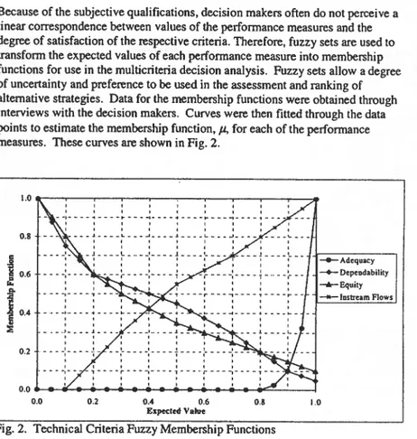
Because of the subjective qualifications, decision makers often do not perceive a linear correspondence between values of the performance measures and the degree of satisfaction of the respective criteria. Therefore, fuzzy sets are used to transform the expected values of each performance measure into membership functions for use in the multicriteria decision analysis. Fuzzy sets allow a degree of uncertainty and preference to be used in the assessment and ranking of alternative strategies. Data for the membership functions were obtained through interviews with the decision makers. Curves were then fitted through the data points to estimate the membership function, J.l, for each of the performance measures. These curves are shown in Fig. 2.
1.0
_-..,.---r--.,....-...,--...,....--r--""""-""""-"",,,,-"'"
" I " ,-
-~----1----~---~----~----~---~----1----I I I I ---I I I I 0.8 ___ ~ ____ L ___ ~ ____ ~ ____ L ___ ~ _ _ _ _ _ _ _ _ ~ __ _ I I I I I I I I I I I I I I I I _ j ___ .L _ .. _.' ____ J ___ . ' . _ _ _ _ _ _ _ .1 ____ '- __ J . } - - - , : : ! : : ~ : I ~Adequacy _ _ Depeodability -A-Equity ----Iastrelm Flows 0.2 0.0 ~_~_+-_+-...
=...;..---I 0.0 0.2 0.4 0.6 Especled Value 0.8 Fig. 2. Technical Criteria Fuzzy Membership Functions1.0
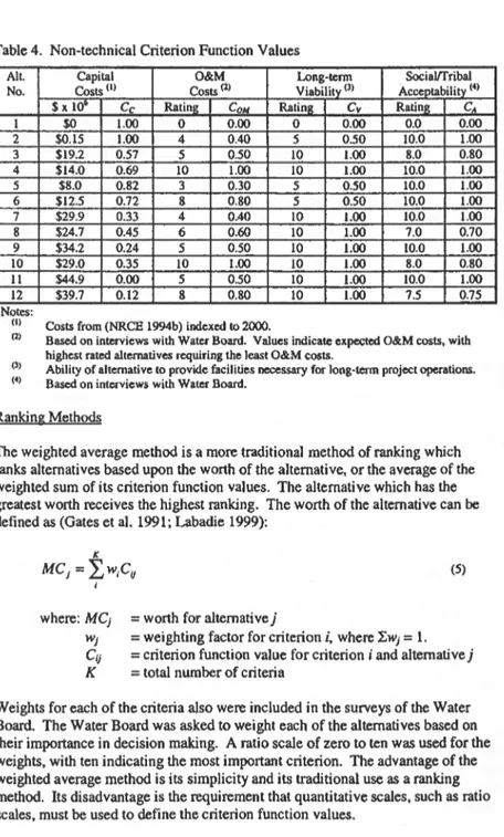
Non-Technical Criteria: Non-technical criteria include capital engineering and construction costs, operations and maintenance costs, fulfillment of long-term project viability and socialffribal acceptance. Unlike the technical criteria, the evaluation of these criteria cannot be obtained through simulation model results. Instead, the criteria are assigned values based on an ratio or ordinal scale. Ratio scales involve a ranking of values based on relative preference, such as an assignment of values between zero and ten for each alternative. Ordinal scales simply rank the alternatives in order of preference, with no gage for preference as related to each other, In this analysis, ratio scales have been used to assign values for all alternatives. To develop commensurable values for the weighted average method, a linear normalization of the scores for each alternative, i, was
I
pedonmd to de""lop critorion f""ction val"" C, • .. shown ;n T.ble 4. p", "",h criterion function value, 1.0 indicates the most preferred alternative.Table 4. Non-technical Criterion Function Values All. No. I 2 3 4 5 6 7 8 9 10 11 12 Notes: (I) (Z) (3) (4)
Capital O&M Long-term SociaVfribal
Costs (I) Costs (2) Viability (3) Acceptability (4)
$xIO· Cc Ratin!!: COM Rating Cv Rating CA
SO 1.00 0 0.00 0 0.00 0.0 0.00 SO.15 1.00 4 0.40 5 0.50 10.0 1.00 $19.2 0.57 5 0.50 10 1.00 8.0 0.80 $14.0 0.69 10 1.00 10 1.00 10.0 1.00 $8.0 0.82 3 0.30 5 0.50 10.0 1.00 $12.5 0.72 8 0.80 5 0.50 10.0 1.00 $29.9 0.33 4 0.40 10 1.00 10.0 1.00 $24.7 0.45 6 0.60 10 1.00 7.0 0.70 $34.2 0.24 5 0.50 10 1.00 10.0 1.00 $29.0 0.35 10 1.00 10 1.00 8.0 0.80 $44.9 0.00 5 0.50 10 1.00 10.0 1.00 $39.7 0.12 8 0.80 10 1.00 7.5 0.75
Costs from (NRCE 1994b) indexed to 2000.
Based on interviews with Water Board. Values indicate expected O&M costs, with highest rated alternatives requiring the least O&M costs.
Ability of alternative to provide facilities necessary for long-term projcct operations. Based on interviews with Water Board.
Ranking Methods
The weighted average method is a more traditional method of ranking which ranks alternatives based upon the worth of the alternative, or the average of the weighted sum of its criterion function values. The alternative which has the greatest worth receives the highest ranking. The worth of the alternative can be defined as (Gates et al. 1991; Labadie 1999):
(5)
where: MCj
=
worth for alternative jWj
=
weighting factor for criterion i, where :EWj=
1. Cij=
criterion function value for criterion i and alternative j K=
total number of criteriaWeights for each of the criteria also were included in the surveys of the Water Board. The Water Board was asked to weight each of the alternatives based on their importance in decision making. A ratio scale of zero to ten was used for the weights, with ten indicating the most important criterion. The advantage of the weighted average method is its simplicity and its traditional use as a ranking method. Its disadvantage is the requirement that quantitative scales, such as ratio scales, must be used to define the criterion function values.
Multi-Criteria Strategic Planning
The PROMETIffiE (preference Ranking Organization Method for Enrichment Evaluation)
n
is an outranking method where the multicriteria are replaced by a single criterion that establishes a complete dominance relation between alternatives. Comparisons between alternatives are evaluated to measure a dominance relationship between the pair. Preference relations. P(a.b). measure the intensity of the preference of given alternative a to a given alternative b. General preference relations include no preference. weak preference. strong preference and strict preference (Labadie 1999). Preference function values.H(d). can be used to numerically describe the preference relation P(a,b). Values of the preference function vary from zero for those alternatives which are indifferent to one for those alternatives in which one alternative is strictly preferred over the other alternative.
The PROMETIffiE II method provides a complete preorder of alternatives. This is accomplished using a net outranking flow:
(6)
where: ;(a)
=
net outranking flow;;+(a)
=
the amount by which alternative a outranks all other alternatives;;-( a)
=
the amount by which alternative a is outranked by all other alternatives.Outranking flows are calculated from preference function values for each pairwise comparison of alternatives. Ranking of the alternatives is then made with the alternative containing the most positive net outranking flow being the highest ranked alternative. Preference function structures are chosen based on the type of data and the general relative strength and structure of the dominance relation between alternatives. Criteria in which there is a high degree of uncertainty in the preference function values would have structures with some degree of
indifference threshold. while those with strict preference may have a structure with no indifference zone. Crit~ria in which the preference is related to the magnitude of difference between the preference function values may use a function structure which allows this variable nature.
RESULTS
Average annual diversion requirements ranged from 108.092 acre-feet for alternative 1 (existing system) to 79.373 acre-feet for alternative 12. with average annual deliveries ranging from 92.215 to 78.159 acre-feet. respectively. The number of years with full demands met ranged from five percent for the existing system to 81 percent for alternative 12.
Criterion function values for the four technical criteria were determined from the perfonnance indicators based upon the simulation resull$. Table 5 presents a summary of the performance indicators and criterion function values for each of the technical criteria. The alternatives which include increased storage
(alternatives 6 and 9-12) all had adequacy measures which met or exceeded the maximum values for those alternatives that do not include increased system storage. This shows the importance of increased storage for improved system adequacy. Dependability. equity and instream flows generally improved with increasing project efficiencies.
Table 5. Performance Indicators and Criterion Function Value Results AI!. Adec uacy Dependability Equity Instrcam Flows No. E./.PA) JIA EJPo) Po E.J.Pc) PE E,fP'F) PI,
1 0.85 0.03 0.17 0.65 0.08 0.84 0.40 0.43 2 0.89 0.08 0.15 0.68 0.06 0.87 0.41 0.44 3 0.90 0.10 0.14 0.69 0.06 0.88 0.41 0.44 4 0.91 0.15 0.13 0.71 0.05 0.90 0.42 0.44 5 0.90 0.11 0.14 0.70 0.06 0.89 0.41 0.44 6 0.97 0.58 0.07 0.82 0.02 0.97 0.43 0.46 7 0.92 0.17 0.12 0.72 0.05 0.90 0.41 0.44 8 0.93 0.21 0.12 0.72 0.05 0.91 0.42 0.45 9 0.98 0.66 0.06 0.84 0.02 0.97 0.42 0.46 10 0.98 0.73 0.06 0.86
om
0.97 0.42 0.45 11 0.98 0.74 0.06 0.86om
0.97 0.42 0.45 12 0.99 0.81 0.05 0.88 0.01 0.98 0.42 0.45 RankingThe results of both the weighted average and PROMETHEE II multicriteria decision analysis schemes are shown Table 6. Alternative 10. reconfiguration and increased storage, was the highest ranking alternative in both methodologies. In general. the highest ranked alternatives included increased storage and/or reconfiguration. The highest ranking rehabilitation alternative was alternative 9 in the weighted average method and alternative 11 in the PROMETIIEE II method. Both of these alternatives incorporate increased storage with rehabilitation, and alternative 11 includes on-farm improvements.
CONCLUSION
The results clearly show the advantages of using a multicriteria decision analysis for investigation of irrigation system rehabilitation alternatives. Previous techniques primarily have considered only technical goals. But. for the Wind River Irrigation Project. as well as many other projects. non-technical goals can have equal or more importance than technical goals. In addition. multicriteria analysis allows a systematic procedure for ranking based on sometimes
Multi-Criteria Strategic Planning
conflicting goals, such as increased irrigation adequacy, long-tenn project viability, capital costs and Tribal/social acceptability. This same benefit also allows a sensitivity analysis of alternative scoring schemes (fuzzy sets and ratio scales) and alternative weighting schemes to determine the overall affect of individual goals on the project. In this analysis, it was found that those alternatives which ranked highest in technical criteria also ranked high in the multicriteria analysis. However, the alternative with the highest technical ranking did not rank first in the multicriteria analysis.
Table 6. MCDA function values and rankings
AI!. Alternative Description Weighted Average PROMETHEE II
No. Me, Rank I/(a) Rank
1 Existinl[ System 0.370 12 -8.01 12 2 System Management Improvements 0.592 9 -3.78 11 3 Rehabilitation of Existi~ ~stem 0.611 8 -2.75 10
4 Reconfiguration of Existing System 0.727 2 1.60 6
5 On-farm IlIlpf'Ovements 0.558 11 -2.72 9 6 Increased Storage 0.714 4 3.14 3 7 Rehab. and On-farm Improvements 0.588 10 -0.70 8 8 Recon. and On-farm Improvements 0.620 7 0.05 7 9 Rehabilitation and Increased Storage 0.689 5 2.57 5 10 Reconfil[uration and Increased Stora~ 0.777 1 4.01 1 11 Rehab .• On-farm Impr. and Inc. Storage 0.665 6 2.94 4 12 Recon., On-farm Impr. and Inc. Storage 0.721 3 3.65 2
The purpose of this analysis was to present the Water Board with a tool for making rational decisions regarding future irrigation system improvements within the Wind River Irrigation Project. The analysis is not intended to provide a finn answer to the question of which improvements should be selected. However. the results show that increased storage is the single most effective means to increase system adequacy, and is in the top-ranking alternatives in both analysis methodologies. However, increased storage alone does not address long-tenn viability of the project. Either rehabilitation or reconfiguration will be required if the project is to survive for the long tenn; the existing system will continue to degrade until many of the channels and structures can no longer deliver irrigation water andlor catastrophic failures occur. The results of the analysis could also be used to stage improvements. Since all high-ranking alternatives include increased storage, Ray Lake could be expanded first. Then, the chosen delivery system improvement, either reconfiguration or rehabilitation. could be implemented, followed by on-farm improvements.
REFERENCES
Daddow. RL. (19%). "Water Resources of the Wind river Indian Reservation. Wyoming." U.S. Gcological Survey. Water-Resources Investigations Report 95-4223. Cheyenne. Wyoming.
Doorenbos. J .• and Pruitt. W. O. (1977). "Guidelines for Predicting Crop Water Requirements." FAO Irrig. and Drainage. Paper No. 24.2"" ed .• FAO. Rome. Italy.
Gates. T.K .• Heyder. W.E .• Fontane. D.G .• Salas. J.D. (1991). "Multicriterion Strategic Planning for ImprOVed Irrigation Delivery. I: Approach." Journal o/Irrigation and Drainage Engineering. ASCE. 117(6).897-913.
Grasso. D.N .• Jennings. M.E. and Sadler. J.S. (1995). "Field Screening of Water Quality. Bottom Sediment, and Biota Associated with Irrigation Drainage. Wind River Indian
Reservation. Wyoming. 1992-93." U.S. Geological Survey. Open-File Report 95-121. Cheyenne. Wyoming.
Heyder. W.E .• Gates. T.K .• Fontanc. D.G .• Salas. J.D. (1991). "Multicritcrion Strategic Planning for improved Irrigation DeliVery. II: Application" Journal 0/ Irrigation and Drainage Engineering. ASCE. 117(6).914-934.
Jensen, M.E .• Burman. RD. and Allen. RG .• eds. (1990). Evapotranspiration and Irrigation Water Requirements. Irrigation and Drainage Division. ASCE. Manuals and Reports on Engineering Practice No. 70. New York.
Labadie. J.W. (1995). "MODSIM: River Basin Network Flow Model For Conjunctive Stream-Aquifer Management Program User Manual and Documentation." Colorado State University. Fort Collins. Colorado. September.
Labadie. J.W. (1999). "Engineering Decision Support and Expert Systems." Class Notes. EG610. Colorado State University. spring 1999 semester.
Pochop. Larry. Travis Teegarden. Greg Kerr. Ronald Delaney and Victor Hasfurther. (1992). "Consumptive Use and Consumptive Irrigation Requirements in Wyoming." University of Wyoming Coorpcrative Extension Service and Wyoming Water Research Center. M87. October.
Natural Resources Consulting Engineers (NRCE). (1994a). "Draft Summary of the Wind River Basin Water Management Studies." Fort Collins. Colorado.
Natural Resources Consulting Engineers (NRCE). (1994b). "Wind River Irrigation Project Assessment and Plan." Fort Collins. Colorado. June.
Natural Resources Consulting Engineers (NRCE). (1995). "Ray Lake System Analysis." Fort Collins. Colorado. July 26.
Roncalio. Teno. (1982). "Report Concerning Reserved Water Rights Claims By and On Behalf of The Tribes of the Wind River Indian Reservation. Wyoming." District Court of the Fifth Judicial District. State of Wyoming. Civil No. 4993. December 15.
Soil Conservation Service (SCS). (1993a). "Irrigation on-farm report for Wind River Basin Water Supply Study." United States Department of Agriculture. February. [Note: Only the
Multi-Criteria Strategic Planning
Interim report. May 1992. was available for review in its fulltexl. Materials extracted from the Interim report were verified with other sources referencing the Final report.) Soil Conservation Service (SCS). (l993b). National Engineering Handbook (NEH. Part 623. Chapter 2 - Irrigation Water Requirements. United States Department of Agriculture. September.
Western Water Consultants (WWC). (1995). "Ray Lake Dam Rehabilitation and Enlargement Final Conceptual Design of Enlargement Report." Laramie. Wyoming. January.
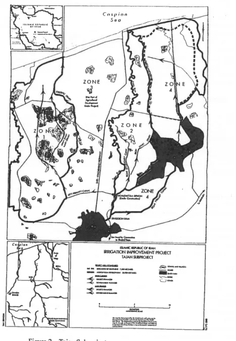
ENVIRONMENTAL MANAGEMENT PLAN FOR TIm IRRIGATION IMPROVEMENT PROJECT (lIP) - TAJAN SUBPROJECT
G. Ayaz:. Ramiz Namvargolianl
Adel Bichara3 Andrew Bond4
ABSTRACT
The Irrigation Improvement Project (lIP) is funded jointly by the Government of Iran and the World Bank. The project with an estimated cost ofUS$ 312 million started in 1994 and is expected to be completed by end of2001. The project implements irrigation improvement measures in about 107,000 hectares in four subproject areas located in northern and southern Iran. Existing irrigation and associated agricultural practices are having environmental impacts on natural and important man made ecosystems both within and downstream of each of the subprojects areas particularly on local and migratory wildlife. A major part ofIIP is an Environmental Management Plan (EMP) which includes in part a) strengthening the institutions and training the personnel responsible for addressing long-term environmental issues related to irrigated agriculture, b) establishing agricultural chemicals management program and surface water and groundwater quality monitoring programs, and c) preparing special studies and mitigation plans to address long-term environmental management issues related to the development of irrigated agriculture.
Good progress has been made with respect to the civil engineering works associated with the project, but a number of issues have delayed environmental mitigation activities associated with the project.
Senior Groundwater Engineer. TccbLink Environmental Inc., Fort Collins, CO 80526; mamvar@TecbLink.c:om
2Environmental Specialist, Khazar-Ab Consulting Engineers, Pasdaran Blvd, Sari, Iran. Senior Irrigation Engineer. Middle East ~ North Africa Region, The World Bank, 1818 H
Street, N.W .• Washington, DC 20433. Abichara@worldbank.org
Environmental Specialist, The World Bank, 1818 H Street, N. W., Washington, DC 20433. Abond@worldbank.org
Special environmental issues oflIP, particularly those associated with the Tajan Subproject and related mitigation actions are presented in this paper. The traditional irrigation in the Tajan subproject area on the Caspian coast ofIran has
resulted in the creation oflarge irrigation water storage ponds locally known lUI
"ab-bandan". Ab-bandans have evolved into complex man-made and
man-maintained ecosystems which are highly valuable to local residents and to local and·
migratory wildlife. A plan of management for the complex ecosystems of
Ab-bandans is being developed.
IRRIGATION IMPROVEMENT PROJECT DESCRIPTION Irrigation receives the largest amount of public agricultural investment in the
developing countries. From 1950 through 1993, seven percent of World Bank lending (US$ 3 I billion) has been devoted to irrigation projects (Jones, 1995). About 69 percent of Bank lending has gone to Asia, while the other 31 percent has been split between Africa, the Americas, and Europe. According to Jones (1995),
"In the 1950s the Bank approved, on average, one irTigation project a year; in the 1960s, four per year; in the 1970s and in the 1980s, 26; and so far in the 199Os, 15. Average irrigation lending per year was $37 million in the 19505, $343 million in the 1960s, $1,120
million in the 1970s, $1,273 million in the 19809, and $1,032
million so far in the 199Os."
More than half of the World Bank's recent lending for irrigation projects has been for extensions, rehabilitations, and upgrades of existing systems.
The Irrigation Improvement Project (lIP) with an estimated cost ofUSS 312
million is funded jointly by The World Bank and The Government of Iran (GOI).
lIP includes four subprojects and preparation orall subprojects is well advanced
and investments will complete and improve existing schemes thus allowing
relatively quick returns in comparison with other potential subsectoral investments in irrigation. GOI is promoting a strategy offull cost recovery for operation and maintenance costs and recovery of 40 percent of on-farm development costs. The project serves as a vehicle for a dialogue on technical issues and on areas where
the Bank's experience such as prevention of environmental degradation will be
used to enhance the governments longer teon irrigation improvement and
development objectives.
The overall objectives of the project (The World Bank, 1993) are to: (a) enhance
water resources management through the rehabilitation and improvement of
irrigation and drainage systems in four subprojects; (b) upgrade agricultural
research and extension in the four subprojects in order to raise crop output, farm
incomes and foreign exchange savings through increased agricultural production; and ( c) improve the planning and implementation capacity of sector institutions,
Environmental Management Plan
including the Ministries of Agriculture, Energy, and the Department of Environment.
Location. Climate and Soils
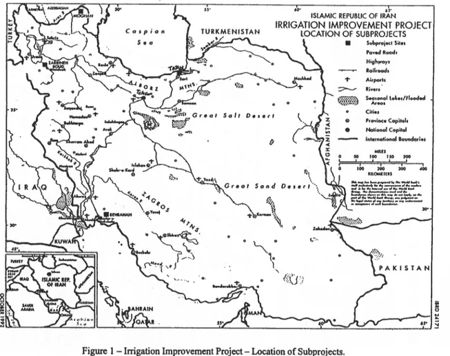
The project with a total area of 107,000 ha and is composed of four subproject areas (Figure 1): Behbahan (11,500 ha), Moghan (35,600 ha), Zarrineh Roud (36,000 ha), and Tajan (23,900 ha). Climatic conditions in the subproject areas vary from semi-arid in the first three subprojects with average annual rainfalls of about 300 mm to sub-humid in Tajan with an average annual rainfall of 650 mm. Soils in the four areas are of alluvial origin and are deep with textures varying from silty loams to clay loarns. Moderate to insignificant slopes in each of the
subproject areas has led to poor drainage, and improved water management, drainage and land leveling activities are supported by the project ..
Land and Farming
Before the project, 77 percent of the project area was irrigated, 16 percent was rainfed and the remaining 7 percent was marginal land used for grazing or left uncultivated, mainly due to salinity and drought problems. In general, land in the subproject areas is privately owned and farmed. Plots are small and land fragmentation is a problem in some areas. Farmers generally cooperate in traditional groups which are valuable asset to the project. Agricultural research and extension centers are present at each of the subprojects and Tajan also benefits from an additional research center dedicated to research on rice. Levels of mechanization differ in each subproject and depends largely on farm size. Farm operations are almost totally mechanized at Moghan subproject. In the other subprojects, land preparation is generally by tractor or on the small farms by power tiller. The most common fertilizer in the project area is urea followed by
diammonium phosphate. Potassium sulphate and triple super phosphate are used in smaller quantities. Pesticide use is widespread with extension services providing training in pesticide use and safety.
The agricultural research stations and service centers are being strengthened through the upgrading of existing staff and through the construction of facilities and the provision of additional staff, vehicles and specialized equipment.
Specialized farm machinery would be made available. Strengthening the operation and maintenance of all facilities starting from the main to the tertiary system,
developing farmer participation through users groups, and addressing critical environmental issues are being emphasized. The project has provided various training and education programs.
-c.:J.:t • (~d"<'t ~m' Grea' . . - A
f&
~
.,.,..
...
...
SO/I D • • • " b ~~...
,
. ~..
~.1.
,
" ~ I.c--{;~\J'i•
'oYed Rood. High"y, loikood, 't" Ailporb :::--- .iv.,.~~~}l&t) Sea.on.1 lol.e/flooded
"'oa.
"
•
Cili.J "oviM. Copilot, Notional Capitcd In •• rnationollovndari •• •• Ho ,00 - -100 kROMEIUS...
,...,,,...
..., .... .. ... ..., ... _ . 1 ... ... _" ... .J_., ... ~ .... . . . ~ __ .-4 ......
-~-.-...-
...
"...,..
~....
-...-~..
:=I.::t:=:--"'-...
:
o ~ 1\;.' .J"'" e H o i " -1\' -",n
-.. ,
'-
T - - . . . " - I ~Figure 1 - Irrigation Improvement Project - Location of Subprojects.
-
"'I "'I ciQ'..,
....
c·
J:I..,
J:I Q,o
..
II ;-» CIQ ~ 5i"....
CI' ~ Z ~ ~~
;;-J:I J:I;:.
a
Environmental Management Plan
Irrigation and Drainage Systems
The existing traditional irrigation systems or partially completed modem ones are highly inefficient in using the scarce water resources. Maintenance of irrigation and drainage networks needs major improvement. Inadequate water conveyance and inefficient on-farm water use have reduced the overall irrigation efficiency to 20 to 30 percent. As a result, there is not enough water to extend the presently irrigated area or to increase yields in the existing areas. Additionally, water logging problems in the low lands reduce crop yields and keep significant areas pennanently or intennittently uncultivated. All four subproject areas receive their primary supply from existing or future water management infrastructure and based on available river flows it is expected that irrigation requirements be met at all times of the year. A planned overaIJ irrigation efficiency of 50 percent is anticipated under the project.
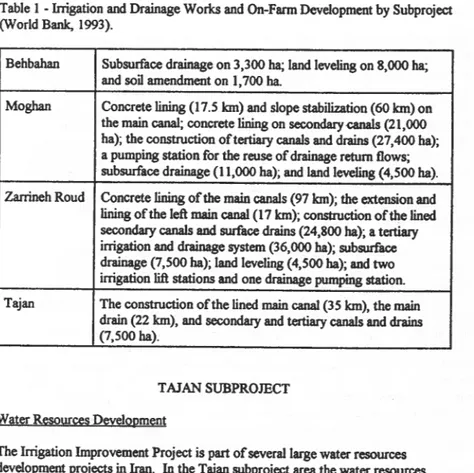
The irrigation and drainage improvement section of the project includes the construction or lining of main, secondary, and tertiary canals and drains. The details of irrigation and drainage works are presented in Table 1. The project consists of the improvement and upgrading of four existing irrigation and drainage systems, serving a total of net irrigable area of about 90,600 ha and the .
intensification of agricultural services on these 90,600 ha and on an additional 16,400 ha in Tajan subproject area. Existing main and secondary canals are provided with concrete lining and in some areas new canals are being added. Main and secondary drains are being improved and expanded to cover all the subproject areas. The tertiary systems are being developed selectively using canalletes, concrete lined or unlined laterals. and open drains. Selective land leveling and subsurface drainage with the emphasis on water management at the tertiary and farm levels are included in the on farm development section of the project.
Environment
The environment component of lIP consists of:
0)
the strengthening of the environmental management capacity of Ministries of Agriculture and Energy and Department of Environment and their provincial offices through specialized training programs and the provision of equipment; (Ii) the development ofagricultural chemical management programs (mcluding integrated pest
management) and model surface and groundwater monitoring programs for each subproject; (Iii) erosion control programs for canal banks in Moghan and river channels in Tajan, (iv) an archaeological site survey in Behbahan; (v) special environmental management studies of the Shadegan Marshes Protected Area in Behbahan subproject area, Lake Orumiyeh National Park in Zarrineh Roud subproject area, "ab-bandan" man-made ecosystems in the Tajan subproject area; and (vi) fishery resources ofBehbahan and Tajan subprojects.
Table I • Irrigation and Drainage Works and On·Farm Development by Subproject (World Bank, 1993).
Behbahan Subsurface drainage on 3,300 ha; land leveling on 8,000 ha; and soil amendment on 1,700 ha.
Moghan Concrete lining (I7.5 Ian) and slope stabilization (60 Ian) on the main canal; concrete lining on secondaryQl18Js (21,000 hal; the construction of tertiary canals and drains (27,400 hal; a pumping station for the reuse of drainage return flows; subsurface drainage (11,000 ha); and land leveling (4,500 ha). Zarrineh Roud Concrete lining of the main canals (97 Ian); the extension and
lining of the left main canal (17 Ian); construction of the lined secondary canals and surface drains (24,800 ha); a tertiary irrigation and drainage system (36,000 hal; subsurface drainage (7,500 ha); land leveling (4,500 ha); and two irrigation lift stations and one drainage pumping station. Tajan The construction of the lined main canal (35 Ian), the main
drain (22 Ian), and secondary and tertiary canals and drains (7,500 ha).
TAJAN SUBPROJECT Water ResourceS Development
The Irrigation Improvement Project is part of several large water resources development projects in Iran. In the Tajan subproject area the water resources project, extending from the Caspian Sea in the north to the Alborz Mountains in the south, includes watershed management, a storage dam, a diversion dam, irrigation development, urban and industrial water supply, electricity generation. The upper reaches of the Tajan is regulated by the storage dam and a watershed management plan for the area above the storage dam is under development. The construction of the reservoir dam has been completed recently. It is a 133 m high double curved concrete dam built on Tajan River about 40 Ian south of city of Sari (Figure 2). Its reservoir can hold up to 192 million cubic meters and can cause a regulated flow of 316 million cubic meters in the Tajan River. The diversion dam was built in 1995 for regulating Tajan River flow to the Tajan plain farm lands. It is located in Sari and has a length of264 m and 18 outlet gates (Figure 2). The irrigation network consists of two main canals that extend to left and right sides of the Tajan River. Several subsidiary canals branch off these two main canals and extend to the fann lands.
Environmental Management Plan Cospion Sea
--..
_ _ _ _ -~,~ aa. _ _ _ ~-=--~-- - -~--Figure 2 - Tajan SUbproject.
t:;:J--"...cc,
--
.aoa, _
~-LJ
-25
The water resources project ofTajan is located in the eastern and western banks of
Tajan River in an area of about 3500 square Jan in two upper and lower sections.
The upper section. south of the provincial railway, is part of the Tajan basin on the northern slopes of the Alborz Mountains and extends from the reservoir dam to the city of Sari. This section with an area of about 2750 square Jan is the middle Tajan River basin and encompasses the eastern and western banks of the Tajan
River. The middle Tajan River basin includes vast irrigated farming, main part of
dry farming. major river sand and gravel exploitation. and pulp and paper and dairy
industries. The lower section with an area of about 700 square Jan extends from
the City of Sari to the Caspian Sea. The Ab-bandan ecosystems are located in the lower section on the left and right banks of the Tajan River.
Ab-bandans
Most of the irrigated farm lands are on the left bank and the rainfed lands are
mostly on the right bank ofTajan River. Accordingly, the left bank ofTajan River
with an area of about 40,000 hectares contains 78 Ab-bandans, and the right bank with an area of about 30,000 hectares contains 31 Ab-bandans. The Ab-bandans in the left and right banks cover about 3515 and 800 hectares, respectively. Ab-bandans have been developed mostly on lands with no direct water rights to Tajan River. More than 340,000 migratory birds come annually to Ab-bandans ofTajan plain for feeding. breeding. wintering. and nesting.
There are 649 pieces of developed Ab-bandans, with a total pond area of about 15,000 hectares, in the western and central regions of the province of
Mazandaran. in the southern shores of Caspian Sea. Tajan plain contains 109
pieces of these Ab-bandans and they cover an area of about 4,300 hectares and annually reserve about 65 million cubic meters of water. Ab-bandans vary in size,
with the smallest and largest in Tajan area having surface areas of 1 ha and 382 ha,
respectively (Khazar-Ab, 1997). While Tajan River provides the largest quantity
of water to the Ab-bandans, rainfall, irrigation return flows or drainage water, and
two nearby rivers contribute to the water stored in the Ab-bandans.
TajanRiver
In addition to being the most important source of agricultural water of the area. the Tajan River is the best habitat of migratory fish including sturgeons. The river originates in the Alborz mountains and after a flowing through 170 Jan of mountainous and flat areas terminates in Caspian Sea. Tajan River with an annual flow of527 million cubic meter and water quality class ofC2S1 is one of the most
important habitats of various endemic and migratory fish among more than 90
Environmental Management Plan
The city of Sari, which does not have a municipal wastewater collection and treatment system, is immediately upstream of the diversion dam. Additionally, more than 20 nearby villages discharge their untreated wastewater to the Tajan River. Wastewater from a thermal mechanical paper plant and a milk plant is discharged up gradient from the diversion dam. Water quality of the Tajan River is also affected by cultivation to the edge of the river and sand and gravel extraction . operations.
Impacts of the Irrigation Improvement Project - Tajan SubprQject
The implementation of the Irrigation Improvement Project in Tajan region was expected to have the following positive impacts:
(i) improved management of irrigated agriculture in a region with extensive irrigated agriculture,
(ii) improved water use efficiency, and
(iii) improved drainage with a reduction in water logging and salinization
risk in an extensive portion of the subproject area.
It was anticipated that the project may increase the potential for some negative impacts if mitigation measures were not included as integral project activities. Converting 7,500 hectares ofrainfed agricultural land to an irrigated agricultural system without improvement in the existing management of agricultural chemicals would result in adverse environmental impacts. The project accomplishment may be influenced by the adverse impacts resulting from the periodic contamination of the irrigation water supply by the upstream discharge of wastewater and excessive sedimentation behind the diversion dam and in the canal system by sediment generated in the mid-Tajan River Basin which are beyond the scope of the project. Risk of prevention of passage of migratory fish through the diversion dam and its fish ladder and outlet gates; and entrance of migratory fish into the irrigation canal
system constitute another possible adverse impact. Also the invaluable Ab-bandans may be developed into farmlands or their surface area may be decreased subsequent to the installation of the irrigation system.
Several mitigation actions are undertaken to reduce the adverse impacts of the
project and the risks that may negatively influence the project achievements. The mitigation actions include: (i) an Agricultural Chemical Management Program. (ii)
a Water Quality Monitoring Program with emphasis on the monitoring of upstream wastewater discharges and discharges from the drains to marine environment, and
(iii) a management program for the Middle Tajan River Basin to establish a river
zoning system to support land use decisions, development of a riverside "set-back" system to reduce bank erosion, pilot riverside afforestation program, and an evaluation of actions which can be taken to reduce excessive sediment generation
and stream bank damage from the extensive sand and gravel excavation and
washing operations.