Competing Interests in
Water Resources
-Searching for Consensus
Proceedings from the
USCID Water Management Conference
Las Vegas, Nevada
Decem ber 5-7, 1996
Sponsored by
u.s. Committee on Irrigation and Drainage Edited by
Herbert W. Greydanus
Bookman-Edmonston Engineering, Inc. Susan S. Anderson
U.S. Committee on Irrigation and Drainage
Published by
u.S. Committee on Irrigation and Drainage 1616 Seventeenth Street, Suite 483
Denver, CO 80202 Telephone: 303-628-5430
Fax: 303-628-5431 E-mail: stephens@uscid.org Internet: www.uscid.org/-uscid
design, construction, operation and maintenance of irrigation, drainage and flood control works; agricultural economics; water law; and environmental and social issues affecting irrigated agriculture. USCID publishes the USCID Newsletter, proceedings ofUSCID meetings, and special reports; organizes and sponsors periodic technical meetings and conferences; and distributes publications of the
International Commission on Irrigation and Drainage. ICID publications include the biannuallCID Journal, Irrigation and Drainage in the World, and the Multilingual Technical Dictionary on Irrigation and Drainage.
For additional information about USCID, its publications and membership, contact:
U.S. Committee on Irrigation and Drainage 1616 Seventeenth Street, Suite 483
Denver, CO 80202 Telephone: 303-628-5430
Fax: 303-628-5430 E-mail: stephens@uscid.org Internet: www.uscid.orgl-uscid
The U.S. Committee on Irrigation and Drainage accepts no responsibility for the statements made or the opinions expressed in this publication.
Copyright C 1997, U.S. Committee on Irrigation and Drainage Printed in the United States of America
Library of Congress Number 97-60367 ISBN 1-887903-03-8
Preface
The papers included in these Proceedings were prepared for the 1996 Water Management Conference Competing Interests in Water Resources-Searchingfor Consensus. The Conference, sponsored by the U.S. Committee on Irrigation and Drainage, was held in Las Vegas, Nevada, December 5 -7, 1996.
The purpose of the Conference was to address and improve understanding of an important problem facing all water users and water suppliers - the problem of competition for sufficient water supplies to meet all needs. The Conference addressed such issues as water rights; conjunctive uses of water; demand management; water marketing and water transfers; and the
environmental, social and economic impacts of proposed solutions to water shortages.
The Conference included Technical Sessions and a Poster Session on four topics:
• Environmental Needs • Demand Management
• Water Marketing and Water Transfers • Social and Economic Impacts
The Proceedings includes 34 papers presented during the Conference. It also includes a Keynote Address by John R. Wodraska, General Manager, Metropolitan Water District of Southern California, and a dinner address by Kenneth R. Wright, President, Wright Water Engineers, and Ruth M. Wright, Board Member, Northern Colorado Water Conservancy District. The U.S. Committee on Irrigation and Drainage and the 1996 Water Management Conference General Chairman extend their appreciation to the speakers, authors, participants and session moderators.
iii
Herbert W. Greydanus Conference General Chairman Sacramento, California
Table of Contents
Session 1: Environmental Needs
Building Consensus in Idaho to Benefit Water Quality, Endangered Species, The Environment, and Irrigation! ... .
Mark A. Limbaugh
Endangered Fish Recovery and Water Development in the Upper
Colorado River Basin. . . .. 15 John Hamill
The CALFED Ops Group: A Process for Resolving Fishery and
Water Supply Conflicts in Water Project Operations ... 29 Katherine F. Kelly, Curtis L. Creel and Robert G. Potter
Water Quality in Transboundary Streams ... 41 Alberto Ramirez and Sergio S. Solis
Fish Friendly Water for Agricultural, Urban and Environmental
Needs: A California Case Study . . . .. 57 Neil Schild and Marilyn Cundiff-Gee
Session 2: Demand Management
Groundwater Management - Building Consensus. . . .. 67 Christie Moon Crother and Behrooz Mortazavi
Competing Water Demands in Jordan: The Need and Opportunity
for Improved Water Management ... 83 W. Martin Roche and Ross E. Hagan
Trumbull Basin Surface Water Management Plan ... 93 Jeffrey R. Vonk and Stephen J. Moran
Competition in the San Juan River Basin ... 101 Rick L. Gold and Errol Jensen
Farmer Adoption ofIrrigation Water Conservation Measures in the
South Platte River Basin ... . . . .. 117 Dan H. Smith, Kathleen C. Klein and Robert C. Ward
Session 3: Water Marketing and Water Transfers
Marketing Yuma Desalting Plant Water While Satisfying American,Mexican, and Environmental Needs ... 127 Gary Bryant and Angela Adams
Transfer of Water Rights from Agricultural to Municipal Uses in
Northern Colorado - A Case Study ... 135 Bruce E. Kroeker and Dennis A. Bode
Water Transfers and Water Pricing in Shared River Basins ... 149 A. Alvares Ribeiro and Rodrigo Maia
Kenneth R. Wright and Patricia K. Flood Session 4: Social and Economic Impacts
Balancing the Increasing Demands on Water Resources within
Heber Valley, Utah ... 193 Karen M Ricks and Reed R. Murray
Economic Impacts of Short-Term Water Transfer Programs - The
Palo Verde Land Fallowing Program Case Study. . . .. 199 Gerald M Davisson and Fadi Z. Kamand
Addressing Selenium Problems in Irrigation Return Flows by
Supporting and Enhancing Existing Programs, Western Colorado ... 205 Richard A. Engberg and N. John Harb
Economic and Environmental Effects of the Glen Canyon
Beach/Habitat-Building Test Flow. . . .. 221 David A. Harpman
MOU on Efficient Water Management Practices by California
Agricultural Water Suppliers - Can it Work? ... , 235 Roger L. Reynolds and Tracy Slavin
Competing Interests in Water Resources - A Rural and Urban Scenario in Andhra Pradesh, India . . . .. 251
P. Lakshminarayana and B. Venkateswara Rao Poster Session
A Probabilistic Assessment of Reservoir Fill under a Range of
Winter Flow Regimes. . . .. 263 Lyn Benjamin
Current Colorado River Issues Relative to Water Deliveries to Mexico . 277 John M Bernal
Bahr El Baqar Drain and Lake Manzala as Affected by Wastewater
(Case Study) ... 283 Hesham Kandil, Safwat Abdel Dayem, Shaden Abdel Gawad
and Mohamed Abdel Khalik
The Impact ofIrrigation with Low Water Quality on Soils, and
Crop Production Under Egyptian Conditions . . . .. 297 Samia EI Guindy and Mohamed Hassam Amer
Linear Programming Applied in the Combined Operation of the
Laterals and the Ponds ... 321 Wen-Tsun Fang and Mei-Jen Peng
Some Enviromental and Social Aspects of Water Resources
Development. . . .. 331 George H. Hargreaves
The Arizona Water Banking Authority: Storing Colorado River Water in Arizona . . . .. 341
Timothy J. Henley and James G. Jayne
A Binational Approach to the Water Management in the Lower
Colorado River Basin ... 353 Francisco Bernal-Rodriquez and Nicolas Zola-Flores
Study on Water Use Plan for Reasonable Irrigation Operation and
Management. . . .. 369 Chun-E Kan and Yu-Chuan Chang
Dams and Environment - Ridracoli: A Model Achievement. ... 383 Pier Paolo Marini
Effluent Reuse from a Wastewater Treatment Pond in Northern
Colorado. . . .. 393
S. A. Mohsin and M. L. Albertson
Water Operations on the Pecos River, New Mexico, and the
Pecos Bluntnose Shiner, A Federally-Listed Minnow ... 407 Lori Robertson
Columbia River Hydrosystem Operation, 1984-1996 - Thirteen Years of Adaptive Flow Management to Rebuild Pacific Salmon Runs ... " 423
Bolyvong Tanovan
Appendix
Keynote Address - How Would Mulholland Do Today? ... '" 437 John R. Wodraska
Dinner Address - Machu Picchu: Its Engineering Infrastructure . . . . .. 45 I Kenneth R. Wright and Ruth M. Wright
Participant Listing ... 477
BUILDING CONSENSUS IN IDAHO TO BENEFIT WATER QUALITY, ENDANGERED SPECIES, THE ENVIRONMENT, AND IRRIGATION!
Mark A. Limbaugh I
ABSTRACT
Balancing the needs of the environment, endangered species, and a healthy agricultural economy within a river basin is challenging. On the Payette River in Idaho, consensus has been reached in an attempt to deal with current demands for water while protecting the reliability of irrigation water supplies. The Payette River system includes 845,000 acre feet of storage in three reservoirs, which is used to irrigate 150,000 acres of farmland and provide minimum pools for local fisheries and recreation. A Biological Opinion issued last year by the National Marine Fisheries Service protecting the listed Snake River salmon under the Endangered Species Act calls for 427,000 acre feet ofIdaho water to be released annually to augment flows on the lower Snake River to benefit migrating smolts. The past few years, 145,000 acre feet from the Payette basin has been leased annually to the local water rental pool by storage contract holders for the purpose of flow augmentation under this BiOp. Renting this water creates a problem with water quality in one of the reservoirs, which has been labeled "water quality limited" by the State of Idaho under the federal clean water act. A local water quality group on the reservoir has opposed drawdowns for flow augmentation during summer months in order to protect water quality and cold water fisheries in the reservoir. Conversely, additional flows during the summer would benefit water quality on the lower Payette River, also designated "water quality limited" by the state. Flows in the river have historically been low in the summer as a result of conserving storage water for irrigation. Low flows during the summer not only aggravate problems with water quality and local fisheries on the river, they also have the same affects downstream on Snake River reservoirs.
I Watennaster, Water District No. 65, Payette River System, 102 N. Main, Payette, Idaho
83661.
In a series of meetings, representatives of all interests on the river discussed what could be done to improve overall river health. Consensus was achieved through compromise, cooperation, and communication. It was decided to split the release; about one half of the water would be released in the summer to benefit the lower river, and the balance would be released during the winter to benefit fisheries and water quality during summer months on the reservoir.
BACKGROUND
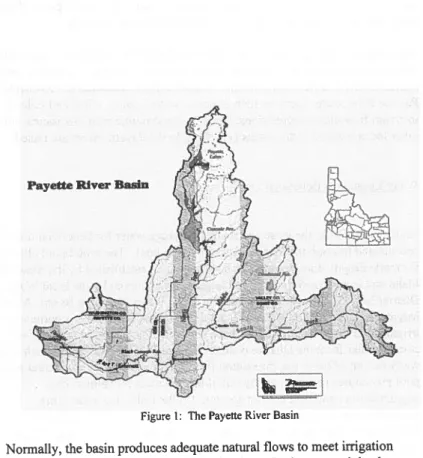
Water District No. 65 was formed in 1992 under Idaho Code as a vehicle for the State ofIdaho to distribute water according to the prior appropriation doctrine to water right holders on the Payette River. A watermaster is elected annually by the water users, and is then appointed by the Director of the Idaho Department of Water Resources. The watermaster is responsible for delivery of Payette River water and overall Water District management. The Water District is funded through assessments paid by water users on the river and administrative fees charged by the rental pool. "Rental pool" refers to the statutory method by which entities may lease their storage water to other users for beneficial uses consistent with state law. Within the District, a total of 150,000 acres are irrigated by two irrigation districts, ten irrigation companies and many private diversions from the Payette River. The Payette River drains approximately 2 million acres and includes three storage reservoirs within the District (Figure 1).
Building Consensus in Idaho 3
Payette River Basin
I
~~
I
Figure 1: The Payette River Basin
Normally, the basin produces adequate natural flows to meet irrigation demands of the senior water rights on the river. Junior water rights have historically been shut off mid-summer of every year, thus creating the need for storage water. Two reservoirs, Cascade and Deadwood, were built by the U.S. Bureau of Rec1amation during the 1930's and 40's and contain over 800,000 acre feet of active storage capacity, while the third reservoir, the Payette Lake system, was built in the early 1900' s by a group of private water users and provides over 35,000 acre feet of storage.
A computer accounting program was developed in 1993, and is used to track river flows and calculate natural flow available for appropriation by water rights on the system. When natural flow drops below the amount being diverted from the river, storage water is released from reservoirs to maintain deliveries. During good water years, water users with storage space in the
reservoirs may lease a portion of their storage water to the rental pool. Water users without storage space may rent water from the rental pool.
Beginning in 1995, the water users of Water District No. 65 have employed a full time watermaster to coordinate water deliveries, storage accounting, and overall Water District management. In addition, the watermaster represents Payette River water users on such issues as water quality, tribal and federal instream flow claim negotiations, legislative and public relations issues, and other forums where water issues pertaining to the Payette River are raised.
Water Leased for Beneficial Use
Under Idaho Code, the lease and rental of storage water for beneficial uses is coordinated through the Water District's rental pool. The rental pool allows for marketing of storage water for beneficial uses established by the State of Idaho and is governed by rules and regulations approved by the local Water District No. 65 Advisory Board and the Idaho Water Resource Board. Many irrigators on the Payette River utilize this rental pool in order to continue to irrigate after their water right has been shut off. The other major renter of storage water from the District is the U.S. Bureau of Reclamation which rents water for out of basin use for salmon flow augmentation. Payette River rental pool procedures require that any out of basin rentals for salmon flow
augmentation constitute the last space to fill the following year. This provision protects irrigation interests with junior water rights, which rely heavily upon their storage space every year, by not subjecting their refill to compete with refill of out of basin uses.
Water Quality Issues
In 1993, a lawsuit was filed against the Environmental Protection Agency by several conservation and environmental groups, arguing that the EPA had not done enough to ensure that the State of Idaho meet the requirements of the federal Clean Water Act on many of its streams and lakes. In the decision, a federal judge in Seattle issued an order in the late spring of 1994 to the EPA and the state to address this problem, listing, among others, the lower Payette River and Cascade Reservoir as high priority, water quality limited stream segments. This listing means that a Total Maximum Daily Load (TMDL) must be approved by EPA before 1998. The Idaho Legislature, in response to
Building Consensus in Idaho
the decision, enacted legislation in the spring of 1995 addressing water quality concerns on 962 stream segments in Idaho by requiring the establishment Basin Advisory Groups (BAG's) and Watershed Advisory Groups (WAG's) on individual watersheds. Members of the BAG's are appointed by the State ofIdaho to oversee the formation of the WAG's, and eventually the setting of a TMDL, on each stream segment listed within a basin. The WAG's are comprised of individuals who represent the different interests on a stream segment listed as water quality limited or impaired. The WAG's, which must be authorized by their governing BAG, have the responsibility of proposing a TMDL on the stream segment they represent to the BAG and the State ofIdaho for approval.
Payette River Stakeholders
Many individuals and organizations are dependent upon the Payette River system for their livelihood. Idaho Power Company is a public utility which provides electricity to irrigators, homes and businesses in Idaho, Eastern Oregon and Northern Nevada. Idaho Power Company generates most of its hydroelectric power at facilities on the Snake and Payette Rivers. All runoff from Southern Idaho eventually goes through Idaho Power's Hells Canyon complex, a series of three dams on the lower Snake River. Irrigation demands and reservoir operations impact Idaho Power Company's ability to produce and market power in the region.
Cascade Reservoir Coordinating Council represents various interests on Cascade Reservoir. Water quality, fisheries and the general health of the reservoir are concerns addressed by this council.
5
Many rafters, kayakers, and sportsmen use the Payette River throughout the year for recreation, fishing and hunting. Between 1983 and 1989, recreational use of the Payette River system grew by 400 percene. The North and South Forks and the Main Payette River are world-class whitewater runs for kayakers and rafters. The Payette River supports four different rafting companies acting as outfitters and guides to paying customers. In addition to the many watersports on the river, many ofthe drainages in the agricultural areas of the basin form wetlands and habitat for waterfowl and upland game birds for hunting. The Payette River also supports both a cold water fishery to the north and a warm water fishery to the south.
2 The Idaho Statesman, "Agencies hope survey will help shape foture of Payette River ", by Pete Zimowsky, August 3 I, 1996.
FLOW AUGMENTATION FOR ENDANGERED SALMON
In 1995, the National Marine Fisheries Service (NMFS) issued a new biological opinion on how to save the endangered salmon runs in the Snake River. The opinion called for 427,000 acre feet of storage water, to be rented or purchased from willing sellers from the upper Snake River basin. The water would be accounted for downstream to meet flow targets at the Lower Granite Dam on the lower Snake River near Lewiston, Idaho.3
In theory, the water would be released from upper reservoirs during fish passage periods to augment the flows at Lower Granite in order to speed the salmon smolts on their journey to the Pacific Ocean. Of the total 427,000 acre feet of water from the upper Snake River basin, approximately 145,000 acre feet are to be rented from the Payette River basin. Idaho Power Company, in association with the Bonneville Power Administration, rented flows from the upper Snake for this effort from 1990 through 1994. This was accomplished by the passage of special legislation by the Idaho Legislature to allow the use of rented storage water for downstream out-of-basin endangered salmon flow augmentation. The original legislation expired on December 31, 1995. In order to meet the new biological opinion's flow targets, new legislation had to be drafted and passed by the Idaho Legislature. A consortium of water users, legislators, governmental representatives and attorneys representing various water interests developed a bill to allow for flow augmentation efforts to continue until the year 2000. Under this bill, which became law in 1996, the water must be rented from the local rental pools designated and approved by the State of Idaho and must be from willing sellers. The water is subject to the procedural rules each local rental pool has established, such as last to fill requirements for out of basin use. Finally, the special legislation must be renewed by the end of 1999, when the current biological opinion expires, in order for continued flow augmentation to occur.
FLOW AUGMENTATION TIMING
J National Marine Fisheries Service, "1995 Biological Opinion/or the Restoration o/the
Building Consensus in Idaho 7
Timing of the salmon flow augmentation water has been an issue of debate. The biological opinion NMFS issued on the endangered salmon species in the Snake River calls for a technical management team, which includes
representatives from all the action agencies involved with the salmon recovery efforts, to "call" for the water when conditions warrant additional flows in the Snake River at Lower Granite Dam. The salmon water comes from various sources in the upper Snake River basin, including several reservoirs in Eastern Idaho, as well as reservoirs on the Boise and Payette Rivers. Coordinating the release of water from these reservoirs at the correct time has been problematic for water managers. To facilitate the release of the flow augmentation water, Idaho Power Company has utilized their Brownlee Reservoir on the Snake River, located below all irrigation facilities in the upper Snake basin, to release fish flows when called for. In order for Idaho Power Company to release water for fish flow augmentation without bearing the financial burden associated with lost powerhead and shifted seasonal generation pattern, Bonneville Power Administration and Idaho Power Company annually enter into an agreement, whereby BP A compensates Idaho Power for these lost revenues by replacing that lost power during winter months, a high demand period.
CASCADE RESERVOIR WATER QUALITY
Cascade Reservoir is a large, shallow reservoir in Central Idaho with a total capacity of 680,411 acre feet, and an active capacity of 636,004 acre feet4
• Many summer homes have been built around the reservoir and fishing and other water sports are enjoyed by many on the reservoir. The reservoir was built to support irrigation in the lower Payette River valley and for power generation at both the Idaho Power Company facility on the dam itself and the U. S. Bureau of Reclamation facility downstream at Black Canyon Dam. The watershed above Cascade Reservoir produces an average annual runoff of 732,550 acre feets. In the eighties and nineties, there were several dry years which compounded water quality problems in the reservoir. During 1994, one of the worst drought years on record for the Payette Basin, water quality in the reservoir declined significantly due to a large drop in the water levels and hot summer temperatures. This drop in water levels was caused by high • Bureau of Reclamation, Cascade Reservoir 1995 Sedimentation Survey, by Ronald L. Ferrari, May, 1996.
irrigation demand due to below average natural flows in the Payette River, and the release of flow augmentation water for salmon migration on the Lower Snake River. With high levels of phosphorus flowing into the reservoir from various sources, many fish and even some cattle grazing around the reservoir were killed by toxic algae blooms.
As a result, the Cascade Reservoir Coordinating Council was formed to address the water quality problems in the reservoir. The group is a grassroots effort by property owners and business leaders whose livelihood and investments depend upon tourism and recreation on the reservoir. The negative publicity resulting from the deteriorating water quality in the reservoir had affected the area tourist industry, causing lost revenues and declining property values to local residents. Many point and non-point sources of pollutants were identified. These sources are currently being dealt with, including the upstream city of McCall sewage treatment plant, a major contributor of phosphorus to the reservoir.6 Best management practices (BMP's), practices which, when applied to normal operations, enhance the quality of runoff or excess waters from these operations, were instituted on several ofthe drainages to the reservoir, as well as cost-share programs for improvements to water delivery and return flow systems on these drainages. Funds for these improvements have been secured from federal and state programs under the Clean Water Act. A total of$2.8 million has been funded for FY95 and FY96 for restoration activities on the reservoir. Another $7.7 million has been planned for the modification of the McCall sewage treatment plant upstream of the reservoir.'
During 1995, as a result of water quality legislation passed by the Idaho Legislature, the Cascade Reservoir Coordinating Council was appointed the official WAG, and is responsible for setting the TMDL on the reservoir.
LOWER PA YETIE RIVER WATER QUALITY
The lower Payette River was also designated a "water quality limited" stream segment in 1995, and consequently was listed as a high priority stream segment within the State ofIdaho under the federal Clean Water Act. A WAG was formed in order to begin setting a TMDL. The WAG is currently
• Cascade Reservoir Watershed Management Plan, Idaho Division of Environmental Quality, October, 1995.
Building Consensus in Idaho 9
monitoring the river, gathering additional information on water quality in order to establish this TMDL. Return flows from surrounding irrigated agricultural lands have historically been a source of sediment, nutrients and bacteria on the lower Payette. These water quality problems are intensified by low flows associated with the operation of the river to deliver water to irrigation diversions. Currently, the Idaho Department of Agriculture is coordinating an effort with several local, state and federal agencies to characterize the water quality of return flows in the agricultural drains. As a result, many irrigators and livestock producers have implemented best management practices to reduce the amount of pollutants entering these drains which flow back to the river. Cost-share programs were used to initiate many of these BMP's, but an increasing number of established BMP's are voluntary efforts by local farmers to help mitigate the water quality concerns on the river.
FLOW AUGMENTATION AND WATER QUALITY - THE PROBLEM
With the advent of flow augmentation rentals from the rental pool, several of the water quality problems on the river have been magnified. During the 1993 water year, the flow augmentation water was released in the summer months to meet downstream requirements at Lower Granite Dam on the lower Snake River. During this year, the reservoirs filled and the summer weather was cool and wet, lessening the need for any water quality improvements to the river or Cascade Reservoir. In 1994, flow augmentation water was again released during the summer months. This year was hot and dry, and the effect of the summertime release was devastating to the reservoir, though the effect on the river was positive. In 1994, Cascade Reservoir did not fill to capacity, and irrigation demand was high. Storage water, normally called for in mid-July, was called for on June 12. Coupled with the summertime fish release, reservoir levels were lowered quite rapidly. Hot summer temperatures at the reservoir and the low water levels resulted in large algae blooms throughout the entire reservoir. As a result, during 1995, the Bureau of Reclamation held the flow augmentation water in Cascade Reservoir for wintertime release, thus keeping reservoir levels high throughout most of the summer months. The 1995 water year was extremely good, with above average snowfall and runoff. Water quality during 1995 in the reservoir was improved, with the
reservoir meeting temperature standards for cold water fisheries for the first time in many years.8
Water quality on the lower Payette River, however, was not as good. Flows were managed to conserve storage water for rental out of basin and to maximize storage water carryover. The Payette River is operated to maintain an operational flow of 135 cubic feet per second at Letha, Idaho, located about 7 miles downstream of Emmett, Idaho (Figure 1). This operational flow at Letha allows for deliveries of water above and below Letha. Return flows from agricultural drains discharge to the river below Letha, resulting in sufficient flows to fill all natural flow rights. At this minimum flow, however, return flows from agricultural drains also cause temperature and sediment problems in the lower reach. Under existing water quality laws, this degradation of water quality by irrigation practices placed the burden on agriculture to improve the quality of return flows to the river. As a result, many BMP's approved by the state's Department of Agriculture, which include the use ofpolyacrylimide compounds (PAM) and straw mulching of irrigation furrows which reduce the levels of sediment and nutrients in the tail waters of treated fields, have been adopted by area farmers in an effort to help meet water quality standards. The impact of the few BMP's put into place on area farmland is already felt at the river, with a definite improvement in water quality in the major agricultural drains. However, the widespread use of BMP's on irrigated acres within the lower Payette basin is many years away, at best.
FLOW AUGMENTATION AND WATER QUALITY - ONE APPROACH
With the listing of the lower Payette River as a water quality limited segment by the State ofldaho, the Cascade Reservoir Coordinating Council called for a meeting with the Water District and federal and state agencies involved with water quality and salmon recovery. The meeting included federal
representatives from Bureau of Reclamation, U.S. Fish and Wildlife, Bonneville Power Administration, state representatives from the Division of Environmental Quality, Fish and Game, and representatives from Idaho Power Company. The meeting focused on the Coordinating Council's concern that improving water quality in Cascade Reservoir may be at the
• Quote from Don Anderson, Idaho Fish and Game, "Pact puts water back into Payette River", by Stephen Stuebner, Star News, August 8, 1996.
/
Building Consensus in Idaho 11
expense of water quality in the lower reach of the river, since holding water in Cascade Reservoir during the summer negatively impacted water quality in the lower Payette River. Also, the higher reservoir levels in 1995 resulted in some erosion of the reservoir banks when a series of storms hit the area. The group agreed to split the flow augmentation releases in 1996. Some of the water would be released in the summer to benefit the lower river and the remaining water would be released in the winter to allow for higher reservoir levels during summer months. Many other issues needed to be addressed including the agreement between Idaho Power Company and Bonneville Power Administration (BPA) to shape flows out ofIdaho Power Company's Brownlee Reservoir. This agreement was crucial to a split release. If the shaping agreement was not in place, all salmon water released from Cascade Reservoir would be required in the late spring and summer months, when called for by the Technical Committee. Using Idaho Power reservoirs on the Snake for timing flows, and replacing those flows with water from upper reservoirs such as Cascade, provides the flexibility to address the concerns previously mentioned. The amount of water to be released in the summer and the winter for a split release needed to be determined. This required a review of snowpack and a review of existing water quality data from Cascade Reservoir to determine an acceptable split.
After analyzing the expected runoff of the snow pack, which was excellent for 1996, and reviewing the status of the shaping agreement, a final meeting was held three weeks before the release of storage flows was to begin. During this meeting Idaho Power representatives informed the group that an agreement was being drafted and all parties had agreed to sign. The efforts to improve water quality on both segments of the river were an incentive to negotiate the shaping agreement. The final task was to agree on the percentages of water to be released in the summer and winter, respectively. Idaho Power
representatives requested a 70/30 summer/winter release; Idaho Fish and Game personnel at Cascade argued for a 30/70 release, indicating that the more water held in-reservoir during summer months the better for the reservoir fisheries. It was decided that a 50/50 release, with half released in the summer and half in the winter, was acceptable to all parties. The fish release began in early July and continued through August. Idaho Power indicated that, during September through November, they do not want any flow augmentation water released into their Snake River reservoirs, as any flows downstream of those reservoirs during this time period affected the nesting fall chinook. Excess water released during nesting periods must continue during the entire nesting period in order to avoid an "incidental take" of that endangered species. Failure to maintain the flow could subject Idaho Power to penalties under the ESA.
RESULTS OF THE SPLIT RELEASE
In the summer of 1996, a total of75,168 acre feet of storage water was released for salmon flow augmentation through the local rental pool. The remaining 76,132 acre feet will be released during winter months to complete the flow augmentation water rented from the Water District's rental pool. The effect of this split release on water quality in the lower Payette River and Cascade Reservoir are not yet available but public reaction has been positive. According to Stephen Stuebner, a reporter for the Star News in McCall, Idaho, increased recreation on the lower Payette River was noted throughout the summertime salmon release. In an article published by the Star News, Stuebner wrote that the split release resulted in " ... a river flow of 1,400 cubic feet per second at Letha, compared to less than 100 cfs a year ago" (see Figure 2). According to the article, the release allowed the Payette River to run "full and wide", with an increase in the number of people enjoying the river at Letha, a contrast to 1995, " ... when the river was reduced to a tiny trickle.,,9 The previous year, Stuebner had written an article complaining about the lack of water in the lower river in order to conserve storage water in Cascade Reservoir.'o
Flows at Letha Gage
2000 . . . . - - - . . . , ~ 1000 o 500 _ . _ _ . _
-oL-~~~~~~~~~
Jul Aug Month SepFigure 2: Flows at the Letha Gage, Lower Payette River' 1
Additional benefits include increased power production at the two
hydroelectric generating facilities on the river: at Cascade Dam and at Black
, Star News, "Pact puts water back into Payelle River", by Stephen Stuebner, August 8, 1996
10 Star News, "Lower Payelle River sufJersfrom Cascade Reservoir hold-back", by Stephen Stuebner, October 5, 1995.
Building Consensus in Idaho 13
Canyon Dam. Power from Black Canyon Dam benefits the Black Canyon Irrigation District and the Emmett Irrigation District as they use power generated at the dam to operate pumps on their delivery systems. If power is not produced during summer months by this facility, these two irrigation districts have to purchased power "wheeled-in" from other sources, at a higher price than locally produced power.
Also, increased flows during July and August on the Payette River benefits a burgeoning whitewater industry. Both private and commercial outfitters were ecstatic about river operations during 1996. In an article written for The Idaho Statesman newspaper in Boise, Idaho, Pete Zimowsky, the Statesman's outdoor recreation editor, stated that "Rafters can be thankful for good flows ... " on the Payette River this season, citing the agreement to split the salmon release from area reservoirs and mentioning the "'win-win' situation for rafting, fishing, water quality, and the endangered salmon.,,12
THE PAYETTE RIVER WATERSHED COUNCIL
In addition to water quality and recreational benefits, another significant achievement to come from the agreement to split the salmon flows is the formation of the Payette River Watershed Council. Membership on the Council consists of representatives from the Cascade Reservoir Coordinating Council, upper basin interest groups, hydropower utilities, the kayaking and rafting community, Idaho river advocacy groups, and irrigation interests on the river through Water District No. 65. An effort is underway to identify and include a number of other Payette River stakeholders on the council, such as recreational mining interests, cities and counties bordering the river, and livestock grazing interests. A draft mission statement reveals the purpose of such a council: "The Payette River Watershed Council is a forum for the open communication and sharing of information concerning the Payette River and its watershed. The purpose of the Council is to encourage and promote a healthy and viable watershed by striving to build understanding, respect for, and consensus among all of the interests in the watershed." The Payette River Watershed Council will negotiate any future agreements on flow
augmentation releases, as well as inform and educate the public about the Payette River and its operations.
12 The Idaho Statesman, "Conditions near perfect/or whitewater players", by Pete Zimowsky, August 8, 1996.
Groups such as the Payette River Watershed Council will be in the forefront as more and more demands are placed on our limited water resources. It has been our experience throughout the year that all stakeholders on the river benefit from the added communication and spirit of cooperation associated with this approach to water management. In good water years, it is much easier to meet the wide variety of needs on a river system such as the Payette. And in preparing for drought years to come, it is imperative that all water interests establish credibility with each other to successfully survive difficult times. The future of water management in the West, and the destiny of irrigated agriculture in Idaho, will depend on our ability as water managers to build consensus among the stakeholders in the decision making process. When irrigated agriculture takes the lead in this process, it succeeds in maintaining its credibility and productivity through the difficult times of continually increasing demands on precious water resources.
ENDANGERED FISH RECOVERY AND WATER DEVELOPMENT IN THE UPPER COLORADO RIVER BASIN
John Hamill1
Today, I am going to talk about two competing interests, endangered fish recovery and water
development in the Upper Colorado River Basin, and a recovery program that was developed to deal with both of these concerns. However, before I start, I would like to address one of the questions that I am
frequently asked: "Why should we recover the endangered fishes in the Colorado River?" After all, the Colorado squawfish and the razorback sucker are not prized sportfish. Nor do they have the charisma of a bald eagle or a gray wolf. The simple answer, of course, is that the Endangered Species Act is the law of the land and it places a high priority on the protection and conservation of threatened and endangered species. The fact that the law has been re-authorized several
different times lends support to the argument that endangered species protection is an important national priority. Public opinion polls seem to support this argument.
To get a more complete answer though, the rationale and purpose of the Endangered Species Act must be examined.
The purpose of the Act is to prevent the extinction of native plants and animals and preserve the ecosystems upon which the threatened and endangered species depend. One of the more compelling reasons I find for this law is the belief that native plants and animals are, in fact, very good barometers of the overall health of the environment--health not just for the endangered fish but for people as well. The fact that
1 U.S. Fish and Wildlife Service, P.O. Box 25486, DFC Denver CO 80225
native plants and animals are having a very difficult time surviving is an indicator that the environment has changed, and if these changes are allowed to go
unchecked, ultimately the quality of human life will be adversely affected.
Let's examine the situation in the Colorado River
basin. In the Upper Colorado River Basin, there are 14
native fish species (Table 1). Five of these are
listed as endangered under the Endangered Species Act, and three are identified as species of concern by the
Fish and Wildlife Service. In summary, over two-thirds
of the native fish community is in some degree of jeopardy in the Upper Colorado River Basin.
I think it is reasonable to assume that if these fish go extinct then many of the values that humans depend
on in this river basin for will be compromised. What
kind of values am I talking about? I am talking about
this river as a source of quality water for growing
crops and for meeting municipal and domestic needs. I
am talking about the river as source of water for
recreation such as fishing, boating, and esthetics--a value which seems to be growing in importance.
Finally, the riparian communities associated with these rivers support about 90 percent of the wildlife in the
arid west. I think it is not unreasonable to assume
that if native plants and animals go extinct many of the values that humans derive from the river also will
be adversely affected. Conversely, if these fish can
be save these values should also be preserved.
The Upper Colorado River Recovery Program grew out of the conflict over how to provide water to support recovery of these endangered fish, while also providing
water to meet human needs in the basin. The geographic
scope of this Program is the Upper Colorado River
upstream of Lake Powell (Figure 1). The San Juan River
Basin, which is technically part of the Upper Basin, was not included in the Upper Basin Program primarily because at that time, it was developed in the early 1980's, there was not a recognized issue related to the endangered fish in the San Juan River.
Table 1
Famil y and Genus SALMONIDAE Salmo Prosopium CYPRINIDAE Ptychochellus Gil a Gil a Gila Rhinichthys Rhinichthys CATaSTOM IOAE Xyrauchen Catostomus Catostomus Catostomus canIDAE Cottus Cottus
Endangered Fish Recovery 17
List of Native Fish Species
Common Name Endemic/Status
clarki pleuriticus Colorado River cutthroat trout
wil1iamsoni Rocky Mountain
lucius cypha elegans robusta osculus yarrowi oscu 1 us thenna 11 s texanus latipinnis discobolus platyrhynchus bairdi beldingi whitefish Colorado squawfish Humpback chub Bony tail chub Roundta il chub Speckled dace Kendall Warm Springs
yes (E) yes (E) yes (E) yes
dace yes (E)
Razorback sucker yes (Cand.) F1annelmouth sucker yes B1 uehead mountain"
sucker Hountain sucker
Mottled sculpin Paiute sculpin
N
1
UPPER COLORAOO RIYER IASIN
,
,
I
,
,
I
,
,
I
,
,
I
WYOftl"G Figure 1Endangered Fish Recovery 19
The Program is made up of Federal, State, and private parties (Table 2). The Program was initiated by a cooperative agreement signed by the governors of Colorado, Utah, and Wyoming; the Secretary of the Interior; and the Administrator of the Western Area Power Administration. Subsequent to that agreement being signed, several major environmental and water user groups provided resolutions supporting the goals and objectives of the Program. By doing so, they became official members of the Program. The Program operates by consensus, meaning that we do not do anything unless all of these parties agree to a course of action.
The Recovery Program consists of five recovery elements:
1. Instream Flows -- Identification and Protection 2. Habitat Restoration
3. Nonnative Fish Control 4. Stocking of Endangered Fish
5. Research Monitoring and Data Management
First, I will briefly describe what they are doing in each of those elements, and then I will talk about some of the broader policy issues related to water
development in the Upper Basin.
The first element deals with instream flows. A fundamental tenet of the Recovery Program is that the flows the fish need will be provided consistent with State law. Another fundamental tenet is that fish need water in specific quantities, in specific locations, and at specific times of the year in order to meet their biological requirements. There are several actions currently being undertaken to restore and protect the flows needed for recovery of the fish. The major activities involves re-regulating the operations of several Bureau of Reclamation facilities in the Upper Colorado River Basin: mainly Flaming Gorge Dam on the Green River; and the Aspinall Units on the Gunnison River. In addition, blocks of water have been set aside in several smaller reservoirs (i.e. Green
Table 2
MISSION
To recover four endangered fish in the Upper Colorado River Basin while providing for future water development to proceed in compliance with the Endangered Species Act.
Federal
U.S. Fish and Wildlife Service U.S. Bureau of Reclamation
Western Area Power Administration
State of Colorado State of Utah State of Wyoming
Colorado Water Congress Utah Water Users Association
Wyoming Water Development Association National Audubon Society
Environmental Defense Fund Colorado Wildlife Federation Wyoming Wildlife Federation
Colorado River Energy Distributors Association· • Nonvoting Member
Endangered Fish Recovery 21
Mountain Reservoir, Ruedi Reservoir, and Steamboat Lake) to assist in providing flows for the fish. We also are looking at coordinating the operation of
several Bureau of Reclamation and private facilities in the upper mainstem of the Colorado River, which
currently provide a lot of the water supply for the Denver metro area. The goal is to coordinate the operations of these reservoirs to enhance peak spring flows for the endangered fish.
Under the Program, the States made a commitment to use their instream flow programs to legally protect
instream flows for the fish. To meet this commitment, the State of Colorado has filed for instream water rights on both the Yampa and Colorado rivers. In addition, the State of Utah enacted a policy to
subordinate new appropriations to the flows recommended by the Fish and Wildlife Service for endangered fish recovery in the Green River. Finally, the Program, through the Bureau of Reclamation, is looking at how irrigation canals in the Grand Valley area of the Colorado River can be more efficiently operated. The water that is saved will be used to enhance flows in the Colorado River.
The principal biological goal of these activities is to more closely mimic the natural or historic hydrograph in these rivers which is characterized by a high spring peak flow and low stable flows during the remainder of the year. There is a growing body of scientific evidence that suggests that the well-being of the endangered fish is tied to the presence of a relatively natural hydrograph.
In addition to providing and protecting instream flows, the Program is doing a lot of things to improve the habitat through physical habitat development. This is a recently taken photo of the Redlands Diversion Dam on the Gunnison River that was built around 1910. Off to the left is a fish-passage structure that
was recently built around that diversion dam. It is designed to provide access to about 50 miles of historical habitat on the Gunnison River for the
endangered fish. Over 8,000 native fish have used the
facility since it went into operation in July.
Recently, one Colorado squawfish use the ladder. In addition to this facility, which is the first of its kind in the upper basin, we have plans to build similar
fish passage ways at a number of other locations in the
Gunnison, Colorado, and Yampa Rivers.
Another important aspect needed for recovery of these
fish is restoration of floodplain habitats. This is a photograph of the Gunnison River back in 1957 prior to construction of the Aspinall Units. This flooding is
characteristic of what used to happen in many parts of
the basin during spring runoff. The river would
essentially get out of its bank and flood bottom lands
areas.
The razorback sucker utilized those areas in the early spring to feed. Also, while the razorback spawns in the river, the larvae drift down the river ending up at these types of flooded bottomland habitats where the
nutrient rich water provides food in order for them to
grow. Today, because of reduced flows and construction of levees and dikes many of these areas are no
longer accessible to fish.
We are working with willing landowners to acquire
easements to allow levees to be removed. The main focus is on the Middle Green River and the Grand Valley area of the Colorado River, and the Gunnison River. The third element of the Recovery Program deals with stocking the native fish. The first 4 to 5 years of the Program were spent studying the genetic composition of wild populations and raising fish with that same kind of genetic diversity in our hatcheries. The genetic surveys are complete and the results are, in
fact, relatively definitive. We have built additional
hatchery facilities to allow more capability to produce
fish. About 2 years ago we started stocking razorback suckers into the Colorado and Green Rivers systems. This last fall, bony tail will be stocked on a limited
Endangered Fish Recovery 23
Moab, Utah. Stocking is especially important to razorback and bony tail recovery because these fish are so rare and there is little or no evidence of
successful recruitment of young fish into the adult population. Hopefully, the actions we have taken to improve habitat and improve instream flows will provide better conditions for them to survive.
Nonnative fishes are a big problem throughout this system. Since the turn of the century there have been about 45 nonnatives fishes introduced into the Upper Colorado River system. Many of these fish are
sportfish like the pike, large-mouth bass, and small-mouth bass. Others are small forage fish like red shiners and fathead minnows were either intentionally or accidentally introduced into the system. In many locations, the total biomass of the river system is probably 90 percent nonnative fishes. There is little doubt that nonnatives fishes are creating major
problems for the native fish.
Our goal is to minimize the impacts the fish are having on the natives. After 3 years of negotiations a set of Nonnative Fish Stocking Procedures were finalized. The Procedures provide guidelines that define the
situations and locations where stocking nonnative fishes is acceptable or unacceptable. We also recently completed a strategy for how to approach control of nonnative fishes in mainstem rivers. Some strategies include mechanical removal of the nonnatives and removing harvest limits on nonnative fish. To date, the primary focus has been on northern pike removal in the Gunnison River and small-mouth bass in the Duchesne River, however, these efforts will be expanded over the next several years.
The final element of the Program deals with research, data management, and monitoring. While we still have an active research component in this Program, during the 4 to 5 years there has been a conscious effort to shift from research into more active on-the-ground kinds of recovery activities, such as restoring flooded bottom land, removing nonnatives, etc. Current
research is directed at trying to better understand the flow requirements of the fish and looking at biological
factors such as imprinting and homing. Since 1986,
there has been a long-term monitoring program in place to track the status and trends of the fish populations.
We are expanding this now to also include looking at
the status and trends of some of the nonnative fish. Finally, a major activity going on this year involves refining the recovery goals for these fish and address the question "When is enough going to be enough?" General recovery goal have already been developed for
each of the four fish. This project will identify some
very specific parameters that define what a healthy self-sustaining population looks like on a river-reach-by-river-reach basis.
As I mentioned earlier, the Recovery Program has two
goals: to recover the fish and allow water development
to proceed in accordance with the Endangered Species
Act. From a water project standpoint, the
accomplishments of this Program are designed to serve as a "reasonable and prudent alternative" for water depletion projects which are subject to section 7
consultation. Since 1988, nearly 300 water projects
with a potential to deplete about 200,000 acre-feet of water have received favorable biological opinions from
the Fish and Wildlife Service. I believe that the
Program has provided much greater regulatory certainty for water users than would have been realized without the Program.
Planning in the Recovery Program centers around the Recovery Implementation Program Recovery Action Plan
(RIPRAP). The RIPRAP identifies specific actions that
will be taken under the Program. The RIPRAP is also
used by the Fish and Wildlife Service as the standard to determine whether or not this Program is achieving
"sufficient progress" for water projects to receive favorable biological oplnlons when they are subject to review under section 7 of the Endangered Species Act. Approximately $42 million has been expended since the
Endangered Fish Recovery 25
part of the funding has come through the Bureau of Reclamation either in the form of power revenues derived from the operation of the Colorado River Storage Projects (CRSP), or more recently, from appropriated funds for capital projects. While the cost of this overall Program is shared by all Program participants, the largest percentage of cost has been born by the Federal Government. About one and a half years ago, Reclamation indicated they could not
continue to fund the Program in the way that they had in the past and that alternative funding mechanisms and cost sharing arrangements were needed to keep this Program viable. As a result, the Program participants began discussing how to provide more stable funding source for both the San Juan and the Upper Colorado River Basin Recovery Program. We got to a point last winter where a Bill that authorized both of the
Programs was drafted. It would provide an $82 million cost ceiling for the Upper Basin Program through the year 2003, which is when the Program expires. For the San Juan Program, the cost ceiling was $22 million until the year 2007 which is when the San Juan Program is set to expire. It specified a cost-sharing
arrangement where the Federal Government would fund 50 percent of the costs, power revenues would be used to fund another 35 percent of cost of the Program, and the States would fund about 15 percent. However, this legislation was put on hold pending resolution of some issues that the water users have. Specifically, the water users wanted more firmer guarantees that water projects would receive favorable biological opinions before they agreed to back the legislation.
I would be remiss in saying that everyone is satisfied with the Recovery Program. In particular, there are recent indications that the water users are not happy with the way the Recovery Program is going. I
understand they have two primary concerns. One is how the Fish and Wildlife Service is conducting section 7 consultations on water projects in the Upper Basin Program. The water users want greater certainty or guarantees that they will be allowed to develop their
compact entitlement in exchange for support of the Program.
Their other issue related to priorities in the Program. They believe that protection and provision of instream flows are being over-emphasized and that greater
emphasis should be directed at stocking razorbacks and bony tails, physical habitat restoration, and nonnative fish control.
My general reaction to that is I do not believe that additional assurances or guarantees can or should be provided. There are a lot of positive things going on in the Program, but there are also many uncertainties about what i t is going to take to recover these fish within existing levels of development. Large amounts of new development will only add to the uncertainties.
In light of those uncertainties, I believe that it would be irresponsible and a violation of the ESA for the Fish and Wildlife Service to give assurance that water development would be allowed to go forward under any circumstances. Greater certainty for the water development will be possible at the time fish populations improve.
In terms of Program priorities there is a process in place for annually evaluating the priorities of the Program. The water users have contributed to and supported the current Program priorities. As always, water users are welcome to submit their priorities for review and see how their ideas stack against other ideas.
I believe that the Recovery Program has worked for water users and the fish. In terms of water development, over 300 water projects have received favorable biological opinions. None of these projects have been litigated since the inception of this
Program. That is a track record that few groups have enjoyed. In addition, the water users have paid less than five percent of the total cost of this Program including the costs for implementing the reasonable and
Endangered Fish Recovery
prudent alternatives for water projects undergoing section 7 consultation.
27
In terms of the fish, many important recovery actions have been implemented as a result of the Recovery Program. I am convinced that the Fish and Wildlife Service can not recover these fish solely by using our section 7 authorities. We need a cooperative effort that has broad political support in order to restore this river system.
I think there are clear motivations for both parties to stay involved in the Program. We have kept this
program healthy by cooperation, and respecting everyone's point of view and working on issues until consensus has been achieved. There's always a strong temptation to fight; a temptation that must be
resisted. Ultimately, i t comes down to every party assessing whether there is a better alternative to the Program. Right now, I believe the Recovery Program is the most effective forum for reconciling conflicts between endangered fish recovery and water development in the Upper Basin. Thank you.
THE CALFED OPS GROUP: A PROCESS FOR RESOLVING FISHERY AND WATER SUPPLY CONFLICTS IN WATER PROJECT OPERATIONS
Katherine F. Kelly' Curtis L. Cree12
Robert G. Potterl ABSTRACT
A unique group of representatives from State and federal water supply and environmental agencies and water user and environmental groups was established in 1994 to help guide the operation of the California state Water Project and the federal Central Valley Project. This group, the CALFED Ops Group, is charged with coordinating the operation of these projects with endangered species constraints, water quality, and requirements of the federal Central Valley Project Improvement Act.
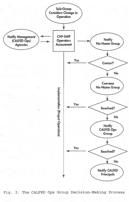
The Ops Group develops short-term operation plans (less than a year) that incorporate improvements for fish with the intent of incurring no net loss of water supply. This is done by using real-time fish monitoring data, sharing facilities, and adjusting regulatory requirements. The Ops Group has defined a process for responding to operational situations quickly while incorporating representatives of all the agencies and stakeholders. The process is designed to have operational decisions made at the lowest level but an issue may be quickly elevated to the policy level if necessary. A description of the decision-making process and examples of the Ops Group efforts are included.
INTRODUCTION
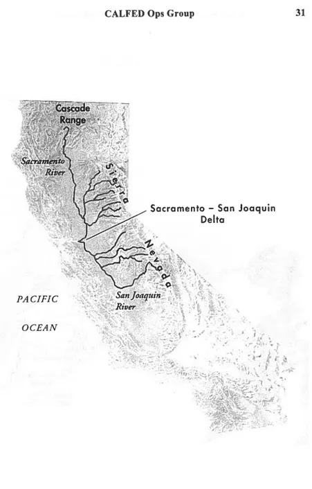
California's topography is dominated by its Central Valley. The valley is formed by two river systems --the Sacramento River and --the San Joaquin River. Both rivers flow into the Sacramento-San Joaquin Delta which flows into the San Francisco Bay and eventually through the Golden Gate to the Pacific Ocean. The Sacramento River flows from the north, originating from the Cascade Range near the Oregon border. The San Joaquin
1 Supervising Engineer, Executive Office, Department of Water Resources, Post Office Box 942836, Sacramento, California
94236-0001.
2 Senior Engineer, Operations and Maintenance Division, California Department of Water Resources
3 Chief Deputy Director, California Department of Water Resources
River flows from the south, originating in the Sierra Nevada Mountains. (Fig. 1)
The Sacramento and San Joaquin rivers are extensively developed with reservoirs and canals to provide flood
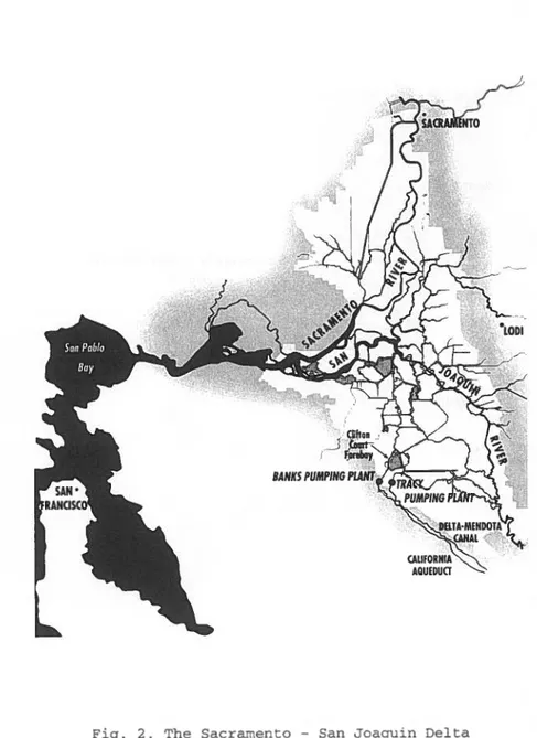
control and water supply. The Delta is an essential
hub for two major water supply systems -- the
California state Water Project and the federal Central
Valley Project. Both projects have large export
facilities in the Delta which pump water made available from unregulated flow and/or releases from the
projects' reservoirs upstream of the Delta. During 1980-1991, the average annual inflow to the Delta was 27.8 million acre-feet (34.3 billion cubic meters)and the total SWP and CVP Delta exports averaged
5.0 million acre-feet (6.2 billion m3) (DWR,1993). Water
exported from the Delta is conveyed via large aqueducts to provide municipal, industrial, and agricultural supply to most of the area south of the Delta. (Fig. 2) The Delta is also the state's most important fishery habitat. It consists of hundreds of miles of channels which provide habitat and passage for an estimated 25 percent of all warm-water and anadromous sport fishing species and 80 percent of the state's commercial fishery (WEF, 1995).
In 1989, fish dependent upon the Delta began being listed under the federal Endangered species Act. The winter-run chinook salmon was listed in 1989, followed by the delta smelt in 1991. These listings had
significant impact upon the operation of the SWP and
CVP because Delta exports could be required to stop if
it were concluded that they threatened the survival of a listed species. Decisions were based upon the number of fish recovered at the fish recovery facilities of
the export facilities. Numeric criteria, called
incidental take limits, were developed to indicate when adjustments in operations may be appropriate.
Sudden shutdown of the export facilities in 1992 due to the presence of winter-run chinook reduced water supply
deliveries by 250,000 acre-feet (0.3 billion m3) (COWA,
1993). Incidental take limits undermined confidence in
CVP and SWP water delivery forecasts. This uncertainty
coupled with several years of drought alarmed
California's agricultural and business communities and financial investment institutions.
Both the federal and State governments recognized the water management and environmental crisis in the Delta and each developed a process to resolve it. Governor Wilson's Water Policy (4/92) titled "Ending California Water Wars" declared "The Delta is broken •••• nowhere is there a greater need for a comprehensive program
PACIFIC
OCEAN
CALF ED Ops Group
Sacramento - San Joaquin Delta
Fig. 1. California's Central Valley
CALF ED Ops Group 33
than in the Delta." It went on to describe his process for resolution. He established the California Water Policy Council consisting of representatives from eight State agencies to oversee the process. The federal government passed the Central valley project
Improvement Act (CVPIA, 10/92) which dedicates up to 800,000 acre-feet (987 million m3)of CVP water supply
to fish and wildlife purposes. In 1993, the Federal Ecosystem Directorate (ClubFED) consisting of
representatives from the u.s. Bureau of Reclamation, u.s. Fish and wildlife Service, u.S. Environmental Protection Agency, and the National Marine Fisheries Service was established to coordinate federal resource protection and management decisions in the Delta and its watershed.
These two processes came together in June 1994 when the California Water Policy council and ClubFED signed the Framework Agreement. To reflect their common intent, the two groups combined to become CALFED. The
agreement committed the State and federal governments to processes for (1) setting water quality standards for the Bay-Delta estuary, (2) developing long-term solutions for the Bay-Delta, and (3) coordinating CVP and SWP operations with endangered species, water quality, and CVPIA requirements. The CALFED Ops Group is the mechanism for implementing the third task. The Ops Group was given additional emphasis with the signing of the Bay-Delta Principles for Agreement on December 15, 1994.
The Ops Group began meeting in August of 1994. The first public meeting was in January 1995. At that meeting, representatives of environmental and water user interests (referred to as "stakeholders") first began providing input to the Ops Group.
OPS GROUP FUNCTION
Ops Group meetings are held monthly and are open to the public. Deliberations are conducted in consultation with stakeholders. For the Ops Group process to be effective, representatives are to be present at Ops Group meetings and participate fully in all
deliberations.
Decisions are made by unanimity of designated representatives of the CALFED agencies. The CALFED agencies are the USBR, USFWS, USEPA, NMFS, California Department of Water Resources, California Department of Fish and Game, and the state Water Resources Control Board staff. Participation of NMFS, USFWS, and DFG in the Ops Group does not limit or constrain their
authority and responsibility regarding federal or State Endangered Species Acts.