Neural network modeling of climate change impacts on irrigation water supplies in Arkansas River Basin
17
0
0
Full text
(2) Elgaali and Garcia. Water shortage is already a problem. Climate change is expected to further stress water resources. Climate change might widen the gap between the demand for and supply of water for irrigation. The changing climate and elevated atmospheric CO2 are expected to influence irrigation by changing evapotranspiration, precipitation, and available water supplies. The combined effect of these changes would impact the supply and the demand. Generally, under warmer conditions the water supply is expected to decrease as demand increases due to rising rates of evaporation and transpiration (Peterson and Keller 1990). Moreover, in an environment of increased temperature and evaporation, the lack of available water will decrease soil moisture. Reductions in soil moisture can greatly reduce agricultural yield (Rosenzweig and Hillel, 1998). The future availability of water for agriculture will depend on possible changes in hydrological regimes at smaller regional scales such as watersheds and river basins. An effective model of climate change that combines weather scenarios with supply and water demand simulations will help with regional planning for environmental change and will give policymakers a tool for evaluating different choices. Potentially, climate change will decrease the supply of water available for agriculture while it increases the demand. As both factors are critical to the future of agriculture, in any projection of regional water budgets, both must be considered (Frederick, 1993). Water supply is a key factor in determining agricultural potential. In scientific studies of models dealing with irrigation water budgets, water supply is usually assumed sufficient. Such an assumption leads to critical uncertainties in these water budgets. The water supply may be affected by changes in quantity, type (snow or rain) and timing of precipitation. Therefore, detailed regional studies are needed of the relation between climate variables such as snow and rain to surface water supply and the sensitivities of water supply to changes in these climatic variables (Ojima et. al, 1999). In this study the possible effects of climatic changes on surface water supplies for irrigation in the Arkansas River basin are investigated using Artificial Neural network (ANN). 2. Description of Study Area 2.1 Location and Physiography This study focuses on the Arkansas River basin in Colorado. The Arkansas River basin is part of the Great Plains area bounded on the west by the Rocky Mountains and by Kansas, New Mexico and Oklahoma on the east and the south (Figure 1). It covers approximately 72,742 km2 (28,415 square miles) about 27 percent of the state of Colorado. It is about 400 km (250 miles) long (east to west) and average about 240 km (150 miles) wide (north to south). The headwaters of the Arkansas River are near Leadville, at an elevation of over 3,050 m (10,000 feet) above sea level. The river’s elevation. 68.
(3) Neural Network Modeling of Climate Change Impacts on Irrigation Water Supplies in Arkansas River Basin. drops rapidly until it emerges from the mountains near Pueblo, then runs in an easterly direction until it reaches the Colorado-Kansas border near Holly, Colorado at an elevation of about 1,036 m (3,400 feet). 2.2 Climate Temperature Temperature and precipitation vary widely in response to topographic differences and the areal extent of the region. Average annual temperatures ranges from 2o C at Leadville in the mountains to 12° C at Lamar in the lower valley. Seasonal variations in temperature are very large, and the region as a whole is characterized by high temperatures in the summer and low temperatures in the winter and spring. Table 2.1 shows some mean temperatures for selected locations in the basin. Precipitation Precipitation is distributed unevenly throughout the year with ranges from 9 to 12 inches per year in the middle and the eastern part of the region, 16 to 20 inches in the western part, and as much as 45 inches in the highest mountain ranges. Much of the precipitation at high elevations occurs as snow. Runoff from this snowfall is at a maximum in late spring and early summer. This runoff constitutes the water supply for different water uses. Growing Season Summers are cool in the mountains and warm in the plains portion of the basin. A maximum temperature over the last thirty years of 35o C has been recorded at Las Animas during July. An average January minimum temperature of -13o C has also been recorded in Las Animas which implies that large temperature variations occur. The average frost free season (between 32 oF threshold) varies from 85 days at Leadville to 167 days at Canon City, 161 days at Las Animas and 162 days at Lamar. 2.3 Water Surface Water The greatest runoff in the basin comes from snowmelt in the large mountain systems at the western border of the region. Water supply varies from year to year depending on the winter snow pack in the mountains. In general, more than 60 percent of the average annual runoff occurs during April through July, and 20 percent during August through October. Trans-Basin Diversions are a significant addition to the basin water supply. There is an extensive system of canals, tunnels, and reservoirs for collecting and transporting water from the western side of the Continental Divide to the Arkansas Basin.. 69.
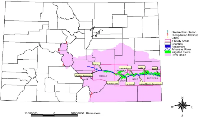
(4) Elgaali and Garcia. $ $ #. $ $. $. Stream flow Station Precipitation Stations Cities 5 Study Areas Counties Reservoirs Arkansas River Irrigated Fields River Basin. Pue blo. $. #. Pue blo R eser voir. $. Lam a r. Las An im a s CROW LE Y # #. PUE BLO. # #. OTE RO R ocky Fo rd. BEN T. La J un ta. Holly #. #. PRO W E RS Jo hn M a rtin Re servo ir. $ $. N W. 10000000. 0. 10000000 Kilometers. Figure 1: Features of the study area in the Arkansas River basin, Colorado. 70. E S.
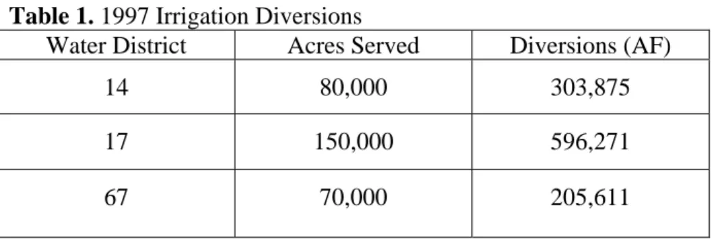
(5) Neural Network Modeling of Climate Change Impacts on Irrigation Water Supplies in Arkansas River Basin. Lakes and reservoirs in the basin serve an important function of controlling natural runoff. Runoff from snowmelt generally peaks during the month of May and early June, but peak demand for water generally occurs in July and August. These bodies of water are used to store water to meet part of the demand. Diversions Diverted water is applied to crops and pasture land in the basin through a huge system of ditches and canals. In this study 21 of these canals are used. These are the major canals serving the farmland in the valley that extends from Pueblo to Kansas. Table 1 shows a summary of diversions for the study area by Water District. In general, the amount of water diverted by these systems averaged 3.5 acre feet per acre for 300,000 acres served (21 canals). The surface diversion data was summarized from records in the Colorado State Engineer Office in Denver. Table 1. 1997 Irrigation Diversions Water District Acres Served. Diversions (AF). 14. 80,000. 303,875. 17. 150,000. 596,271. 67. 70,000. 205,611. 3. Methods In this study historical and scenarios of climate data were used to quantify the responses of water supplies for irrigation to changes in climate. Artificial Neural Network (ANN) methodology was used to model the surface water supply system. The ANN is trained to approximate the relation between the amount of water diverted for irrigation and the river flow and precipitation on the river basin being modeled. In order to meet the research objectives the following steps were involved: 1. Selection of a region vulnerable to climate change with reliable records of data. 2. Selection of climatic cells representative for the whole river basin. 3. Selection of climate scenarios with high spatial resolution to meet the objectives of this study. 4. Development of a model from existing climatic and runoff records that adequately simulated diverted water. 5. Use of this model to determine the effects of climate change.. 71.
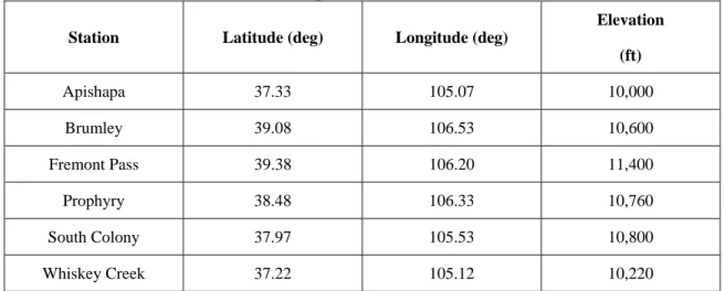
(6) Elgaali and Garcia. 3.1 Selection of Study Area Region Selection Generally, in developing a database for this kind of research, preliminary considerations should be given to issues like scale of analysis, the availability, accuracy, and adequacy of the data for the modeling and validation processes. Such considerations eventually led to selection of Arkansas River basin as study area. In general, the basin was selected to fulfill a number of criteria required for development and testing of the modeling system. It is especially important that the basin: 1) Have enough records of diversions and river flow for modeling and validation. 2) Have a surface irrigation system adequate for reproducing the surface water supplies under historical, current and climate change effects. 3) Have an area that encompasses a variety of land covers and acreages to reflect the variability in responses to climatic effects. 4) Have a river system of flow records that reflect the natural runoff. Irrigated agriculture is the dominant surface management in the basin. The study area contains two major reservoirs and twenty one ditches which transmit water to an irrigated area of 270,000 acres out of a total area of 390,000 acres. Climate Stations Substantial water supply (runoff) occurs only where mountain ranges are high enough to receive adequate precipitation. By far the greatest runoff comes from snowmelt in the large mountain system at the western borders of the region. Therefore, consideration was first given to locating climatic stations in the mountains that representative to the runoff in Arkansas River. For stream flow it is especially important that the flow records reflects the natural runoff and with high correlation with amount of water diverted over the whole basin. The best stations (recommended by USGS) are listed in Table 2 and shown on Figure 1. Table 2. Characteristics of Precipitation Stations Elevation Station. Latitude (deg). Longitude (deg) (ft). Apishapa. 37.33. 105.07. 10,000. Brumley. 39.08. 106.53. 10,600. Fremont Pass. 39.38. 106.20. 11,400. Prophyry. 38.48. 106.33. 10,760. South Colony. 37.97. 105.53. 10,800. Whiskey Creek. 37.22. 105.12. 10,220. 72.
(7) Neural Network Modeling of Climate Change Impacts on Irrigation Water Supplies in Arkansas River Basin. Climate Scenarios Generally, historical and scenario-driven approaches are used to design and conduct climate change impacts simulations. In this study two GCMs were used to evaluate the climate change impacts. The two GCMs are the transient HAD, which was developed by Hadely Center for Climate Prediction and Research, United Kingdom and the transient CCC, which was developed by the Canadian Center for Climate Prediction and Analysis. The two models projections were generated assuming 1% increase in CO2 concentrations. The National Center for Atmospheric Research (NCAR) regionalized (downscaled) the output of these two models to a resolution of 0.5oX0.5o. The data from the two models cover historical period 1895-1993 and projected period 1994-2099. The characteristics of the two downscaled GCMs are shown in Figure 2. 3.2 Modeling Water Supply Artificial Neural Network (ANN) was used to model the monthly water supply in the basin. Artificial Neural Network is a technique able to learn, estimate and generalize a relationship between inputs and outputs of the same pattern in a system. The data set is usually divided into two parts. The first part is used to train the network to estimate the relationship between the inputs and outputs while the second part is used to validate that relationship. In this study a feedforward neural network was used to map the relation between the water diverted for irrigation in the region (output) and the streamflow/precipitation (input). The hydrological variables modeled are the precipitation on the mountain (PPTm), the precipitation on the basin area (PPTb), river flow (Qr) and the amount of water diverted for irrigation (D). The diversion D at time (t) is treated as a function of Qr, PPTm and PPTb at time (t) and (t-1) as follows: D (t) = f (Qr(t), PPTm(t), PPTm(t-1), PPTb(t), PPTb(t-1)). (1). 4. Model Testing and Validation Usually, part of the data used in developing the neural network is used to validate the model since it has the same pattern of the training data. In the validation stage, the network after having been trained is being checked to see if it still performs satisfactorily with data that was not used during the training of the network. Thus the network developed was tested using data whose pattern is the same as the data used for training. The performance statistics shown in table 3 were used to summarize the relationships between the output of the network and the target values being modeled.. 73.
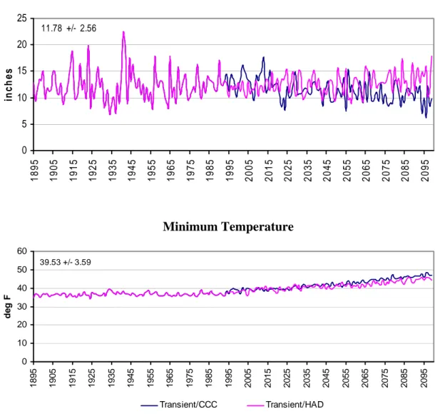
(8) Elgaali and Garcia. 5. Effects of Climate Change Results of the model simulations are shown on Tables 4 and 5 and Figures 3-5. Figure 3 depicts the average of 10 years of historical seasonal water diversions compared to the diversions projected by the two GCMs CCC and HAD. Figure 4 shows the seasonal changes due to climatic change in years 2060 and 2090 compared to changes in the base line (19601990). Figure 5 shows the deviations of monthly diversions in 2060 and 2090 from baseline diversions (1960-1990).. Annual Precipitation 25 11.78 +/- 2.56. in ch es. 20 15 10 5. 2035. 2045. 2055. 2065. 2075. 2085. 2095. 2035. 2045. 2055. 2065. 2075. 2085. 2095. 2025. 2015. 2005. 1995. 1985. 1975. 1965. 1955. 1945. 1935. 1925. 1915. 1905. 1895. 0. Minimum Temperature 60 39.53 +/- 3.59. 50. 30 20 10. Transient/CCC. 2025. 2015. 2005. 1995. 1985. 1975. 1965. 1955. 1945. 1935. 1925. 1915. 1905. 0 1895. deg F. 40. Transient/HAD. Figure 2. Time series of Annual Precipitation and Minimum Temperature. The figure includes both historical data from 1895-1993, and projections for 1994-2099.. 74.
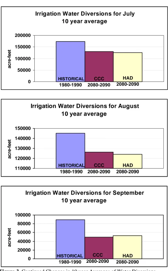
(9) Neural Network Modeling of Climate Change Impacts on Irrigation Water Supplies in Arkansas River Basin. Table 3. Summary of the Model Validation and Testing Month. APRIL MAY JUNE JULY AUG. SEPT. Training R2 0.979 0.904 0.978 0.967 0.997 0.946. R 0.989 0.951 0.989 0.983 0.998 0.973. Testing RMSE 0.022 0.104 0.039 0.042 0.011 0.052. R 0.909 0.845 0.896 0.895 0.910 0.906. R2 0.826 0.715 0.802 0.801 0.827 0.821. RMSE 0.095 0.120 0.109 0.086 0.088 0.133. Generally, as shown in Figure 3, the projected amount of water for irrigation moderately decreases to the end of this century. The GCMs projected an average decrease of 20 percent from the current amounts of water available. Table 4. Simulated Seasonal Diversions Averages in acre-feet Month April May June July August September. Base line Avg. 1960-1990 93316 140887 182017 174398 145014 89149. CCC Avg. 2080-2090 92532 111400 144757 130778 126126 49710. HAD Avg. 2080-2090 89989 111985 144584 125817 124225 52678. Table 5. Simulated Seasonal Diversions in 2060 and 2090 in acre-feet Month April May June July August September. CCC 2060 106878 151685 153140 73386 54916 42456. HAD. 2090 73100 116177 166573 90824 94263 49844. 2060 96287 144733 163386 60629 54242 42456. 2090 70946 111767 88562 88562 93599 26484. The 10-year diversion averages projections decrease in every month in the season except in April (Figure 3). This is due to the high projected temperature which leads to early snow melt. The amount of the snowmelt is large enough to offset the effect of the evapotranspiration (ET) and becomes runoff boosting the water supplies. The two GCMs scenarios gave almost the same average annual projections of water diversions. Since the two GCMs have the same range of temperature projections, this indicates that temperature is more dominant. 75.
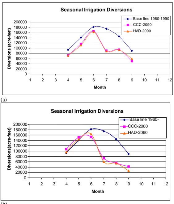
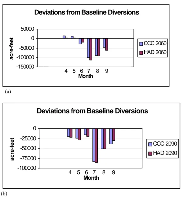
(10) Elgaali and Garcia. than precipitation in projecting annual water supplies, because temperature is controlling other factors involved in the hydrologic cycle such as humidity and vapor pressure gradient. Based on the data from the two GCMs, moderate increases in diversions are projected to occur in the months of April and May in 2060 and then the amount of water decreases during the rest of the season (Figure 4). The increase in water supplies comes from the early snowmelt in the mountains. Both of the GCMs project increases in winter snow and a decrease in summer precipitation by the year 2060. The increase of snow is very significant reaching approximately 70 percent of the current amounts while the decrease in precipitation mounts to 40 percent. The increase in winter snow coupled with high projected temperatures results in early snow melt and early seasonal water availability while the decrease in summer precipitation results in water shortage especially during the growing season. These conditions continue and prevail in 2090. In 2090 due to the prevailing climatic conditions there is a reduction in water supplies over the whole season (Figure 4). Figure 5 shows the simulated deviations from monthly baseline diversions in 2060 and 2090. In 2060 the deviations of the first two months in the growing season (April and May) are positive which indicates increases in water supplies while the negative values indicate a decrease. In 2090 the early snowmelt reduces the summer runoff and hence the water supplies over the whole season. 6. Summary The two GCMs used in this study, CCC and HAD, project an increase in temperature (4 – 7o C) and winter precipitation and a decrease in summer precipitation. Based on these projections the study region is expected to get drier. These dry conditions have adverse effects on water supplies in the region. Following the projected precipitation patterns, a decrease in water supply occurs. In 2060 a reduction in water supplies occurs from midseason (April/May) to the end of the season (June-Sept.). In 2090, based on the projections, water is short over the whole season. High projected temperature increases ET and alters snowmelt time causing a shift in water availability to late winter and early summer. The study region is one of the regions most vulnerable to climate change. Water shortage is already a problem in the region. If precipitation amounts and timing change as projected the water resources in the region will be under more stress. The results of this study are intended to give insights into changes of seasonal water supplies under two GCM projected scenarios.. 76.
(11) Neural Network Modeling of Climate Change Impacts on Irrigation Water Supplies in Arkansas River Basin. Irrigation W ater D iversions for April 10 year average 100000. acre-feet. 80000 60000 40000 20000 0. HISTORICAL. 1980-1990. CCC 2080-2090. HAD 2080-2090. Irrigation Water Diversions for May 10 year average 150000 acr e- 100000 fee t 50000 0. CCC HISTORICAL 2080-2090 1980-1990. HAD 2080-2090. Irrigation Water Diversions for June 10 year average 200000 ac 150000 refe 100000 et 50000 0. CCC HAD HISTORICAL 1980-1990 2080-2090 2080-2090. Figure 3. Changes in 10 year Averages of Water Diversions. 77.
(12) Elgaali and Garcia. Irrigation Water Diversions for July 10 year average 200000. acre-feet. 150000 100000 50000 CCC 2080-2090. HISTORICAL. 0. 1980-1990. HAD 2080-2090. Irrigation Water Diversions for August 10 year average. acre-feet. 150000 140000 130000 120000 110000. HISTORICAL. CCC 2080-2090. 1980-1990. HAD 2080-2090. Irrigation Water Diversions for September 10 year average 100000. acre-feet. 80000 60000 40000 20000 0. HISTORICAL. 1980-1990. CCC 2080-2090. HAD 2080-2090. Figure 3. Continued Changes in 10 year Averages of Water Diversions 78.
(13) Neural Network Modeling of Climate Change Impacts on Irrigation Water Supplies in Arkansas River Basin. Diversions (acre-feet). Seasonal Irrigation Diversions Base line 1960-1990. 200000 180000 160000 140000 120000 100000 80000 60000 40000 20000 0. CCC-2090 HAD-2090. 1. 2. 3. 4. 5. 6. 7. 8. 9. 10. 11. 12. Month. (a). Diversions(acre-feet). Seasonal Irrigation Diversions Base line 19601990 CCC-2060 HAD-2060. 200000 180000 160000 140000 120000 100000 80000 60000 40000 20000 0 1. 2. 3. 4. 5. 6. 7. 8. 9. 10. 11. 12. Month. (b) Figure 4 (a) Simulated Changes in Water Diversions in 2090 (b) Simulated Changes in Water Diversions in 2060. 79.
(14) Elgaali and Garcia. Deviations from Baseline Diversions. acre-feet. 50000 0. CCC 2060. -50000. HAD 2060. -100000 -150000. 4 5 6 7 8 Month. 9. (a). Deviations from Baseline Diversions. acre-feet. 0 -25000. CCC 2090. -50000. HAD 2090. -75000 -100000. 4 5 6 7 8 Month. 9. (b) Figure 5. Simulated projected deviations from baseline diversions in (a ) 2060 and (b) 2090 References Abu-taleb, M. F., 2000. Impacts of global climate change scenarios on water supply and demand in Jordan. Water International 25(3): 457-463. Adams, R. M., C. Rosenzweig, R. M. Peart, J. T. Ritchei, B.A. McCarl, J. D. Glyer, R. B. Curry, J. W. Jones, K. J. Boote, and L. H. Allen, Jr. 1990. Global climate change and US agriculture. Nature 345: 219-224. Arnell, N., 1996. Global warming, River Flows and Water Resources. Wiley, West Sussex, England. Bergstrom, S., B. Carlsson, M. Gardelin, G. Lindstrom, A. Pettersson, and M. Rummukainen, 2001. Climate change impacts on runoff in Sweden – assessment by global climate models, dynamical downscaling and hydrological modeling. Climate Research 16(2): 101-112.. 80.
(15) Neural Network Modeling of Climate Change Impacts on Irrigation Water Supplies in Arkansas River Basin Carter, T. R., M. L. Parry, S. Nishioka, and H. Harasawa, 1994. Technical Guidelines for Assessing Climate Change Impacts and Adaptations. IPCC, University College London, and Center for Global Environmental Research, Tsukuba. pp51. Chen, C. C., D. Gillig, and B. A. McCarl, 2001. Effects of climatic change on water dependent regional economy: A study of the Texas Edwards Aquifer. Climatic Change 49(4): 397-409. Chew, F. H. S., P. H. Whetton, T. A. McMahon, and A. B. Pittock, 1995. Simulation of the Impacts of Climate-Change on Runoff and Soil Moisture in Australia Catchments. Journal of Hydrology 167(1-4): 121-147. Cooley, K. R., 1990. Effects of CO2- Induced Climatic Changes on Snowpack and Streamflow. Hydrological Science Journal 35(5): 511-522. Dugan, J. T., T. McGrath and R. B. Zelt. 1994. Water-Level Changes in the High Plains Aquifer-Predevelopment to 1992. U.S. Geological Survey. Water-Resources Investigations Report 94-4027. Lincoln, NE. Dvorak, V., J. Hlandy, and L. Kasparek, 1997. Climate change hydrology and water resources impact and adaptation for selected river basins in the Czech Republic. Climatic Change 36(1-2): 93-106. Flood, I., and N. Kartam, 1994. Neural networks in civil Engineering. I:Principles and understanding. Journal of Computing in Civil Engineering 8(2): 131-148. Flood, I., and N. Kartam, 1994. Neural networks in civil Engineering. I: Systems and applications. Journal of Computing in Civil Engineering 8(2): 149-162. Frederick, K. D. 1993. Climate change impacts on water resources and possible responses in MINK region. Climatic Change 24:83-115. Frederick, K. D. 1997. Adapting to climate impacts on the supply and demand for water. Climatic Change 37(1): 141-156. Fyfe, J. C. and G. M. Flato, 1999. Enhanced Climate Change and Its Detection Over the Rocky Mountains. Journal of Climate 12(1): 230-243. Giorgi, F., C. S. Brodeur, and G. T. Bates, 1994. Regional climate change scenarios over the United States produced with a nested regional climate model. Journal of Climate 7: 375399. Goh, A. T. C., 1995. Modeling soil correlations using neural networks. Journal of Computing in Civil Engineering 9(4): 275-278. Hartig, E. K., O. Grozev, and C. Rosenzweig, 1997. Climate change, agriculture and wetlands in Eastern Europe: Vulnerability, adaptation and policy. Climatic Change 36(12): 107-121. Hsieh, W. W., and B. Tang, 1998. Applying neural network models to prediction and data analysis in meteorology and oceanography. Bulletin of the American Meteorological Society 79(9): 1855-1870. Hsu, K., H. V. Gupta, and S. Sorooshian, 1995. Artificial neural network modeling of the rainfall-runoff process. Water Resources Research 31(10): 22517-2530. Hurd, B., N. Leary, R. Jones, and J. Smith, 1999. Relative regional vulnerability of water resources to climate change. Journal of the American Water Resources Association (JAWRA) 35(6): 1399-1409. Idso, S. B. and A. J. Brazel, 1984. Rising Atmospheric Carbon Dioxide May Increase Streamflow. Nature 312(1): 51-53. 81.
(16) Elgaali and Garcia. IPCC. 1996. Climate Change 1995: The Science of Climate Change. J. T. Houghton, L.B. Meira Filho, B. A. Callander, N. Harris, A. Kattenberg, and K. Maskell (eds.). Intergovernmental Panel on Climate Change. Cambridge University Press. Cambridge. IPCC. 2001. Climate Change 1995: The Science of Climate Change. J. T. Houghton, L.B. Meira Filho, B. A. Callander, N. Harris, A. Kattenberg, and K. Maskell (eds.). Intergovernmental Panel on Climate Change. Cambridge University Press. Cambridge. Irmgard F., C. W. Stockton, and W. R. Boggess, 1987. Climatic Variation and Surface Water Resources. Water Resources Bulletin 23(1): 47-57. John, T. C., R. E. Carnell, J. F. Crossley, J. M. Gregory, J. F. B. Mitchell, C. A. Senior, S. F. B. Tett, and R. A. Wood, 1997. The Second Hadley Centre Coupled Ocean- Atmosphere GCM: Model Description, Spinup, and Validation. Climate Dynamics 13:103:134. Karunanithi, N., W. J. Grenney, D. Whitley, and K. Bovee, 1994. Neural networks for river flow prediction. Journal of Computing in Civil Engineering 8(2): 201-219. Kuligowski, R. J., and A. P. Barros, 1998. Using artificial neural networks to estimate missing rainfall data. Journal of American Water Resources Association 34(6): 14371447. Lane, M. E. P. H. Kirshen, and R. M. Vogel, 1999. Indicators of impacts of global climate change on US water Resources. Journal of Water Resources Planning and ManagementASCE 125(4): 194-204. Leavesley, G. H., 1994. Modeling the Effects of Climate Change on Water Resources- A Review. Climatic Change 28:159-177. Li, P. J., 1999. Variation of snow water resources in northeastern China, 1951-1997. Science in China Series D-Earth Sciences 42:72-79. Loaiciga, H. A., D. R. Maidment, and J. B. Valdes, 2000. Climate change impacts in a regional Karts aquifer, Texas, USA. Journal of Hydrology 227(1-4): 173-194. McFatlane, N. A. G. J. Boer, J. P. Blanchet, and M. Lazare, 1992. The Canadian Climate Centre Second-Generation General Circulation Model and Its Equilibrium Climate. Journal of Climate 5: 1013-1044. Nash, L. L. and P. H. Gleick, 1993. The Colorado river Basin and Climatic Change: The Sensitivity of Streamflow and Water Supply to variations in Temperature and Precipitation. Report Prepared for the U.S. Environmental Protection Agency, Office of Policy, Planning and Evaluation – Climate Change Division, EPA 230-R-93-009, Pacific Institute for Studies in Development, Environment, and Security, Oakland, California, 91 pp. Ojima, D., L. Garcia, E. Elgaali, K. Miller, T. G. F. Kittel, and J. Lackett, 1999. Potential Climate Change Impacts on Water Resources in the Great Plains. Journal of the American Water Resources Association 35(6): 1443-1454. Parton, M. Hartman, D. S. Ojima, and D. S. Schimel, 1998. DAYCENT and its land surface submodel: description and testing. Global Planetary Change 19:35-48. Peterson, D. F. and A. A. Keller. 1990. Irrigation. In P. E. Waggoner (ed.). Climate Change and Water Resources. Wiley. New York. pp 269-306. Rango, A., and V. Van Katwijk, 1990. Water Supply Implications of Climate Change in Western North American Basin. International and Transboundary Water Resources Issues, American Water Resources Association 27th Annual Conference Proceedings. AWRA, Bethesda, Maryland. Rango, A., 1992. Worldide Testing of the Snowmelt Runoff Model with Applications for Predicting the Effects of Climate Change. NORDIC Hydrology 23(3): 155-172.. 82.
(17) Neural Network Modeling of Climate Change Impacts on Irrigation Water Supplies in Arkansas River Basin Rango, A., 1995. Effects of Climate Change on Water Supplies in Mountainous Snowmelt Regions. World Resources Review 7(3): 315-325. Revelle, R. R. and P. E. Waggoner, 1983. Effects of Carbon Dioxide-induced Climatic Change on Water Supplies in the Western United States. In: Changing Climate. Report on the Carbon Dioxide Assessment Committee, National Academy Press, Washington, D.C., pp 419-432. Rosenberg, N. J., B. A. Kimball, P. Martin, and C. F. Cooper. 1990. From climate and CO2 enrichment to evapotranspiration. In P. E. Waggoner (ed.). Climate Change and Water Resources. Wiley. New York. PP 151-175. Rosenberg, N. J., P. R. Crosson, K. D. Frederick, W. E. Easterling, III, M. S. McKenney, M. D. Bowes, R. A. Sedjo, J. Darmstadter, L. A. Katz, and K. M. Lemon 1993. The MINK Methodology: Backgound and Baseline. Climatic Change 24: 7-22. Rosenzweig, C. and D. Hillel. 1993. The dust bowel of the 1930s: Analog of greenhouse effect in the Great Plains? Journal of Environmental Quality 22(1): 9-22. Rosenzweig, C. and D. Hillel. 1998. Climate Change and the Global Harvest: Potential Impacts of the Greenhouse effect on Agriculture. Oxford University Press. New York. Schaake, J. C., 1990. From climate to Flow. In P. E. Waggoner (ed.). Climate Change and Water Resources. Wiley. New York. PP 177-206. Schulze, R., J. Meigh, and M. Horan, 2001. Present and potential future vulnerability of eastern and southern Africa’s hydrology and water resources. South African Journal of Science 97(3-4): 150-160. Stockton, C. W. and W. R. Boggess, 1979. Geohydrological Implications of Climate Change on Water Resources Development. Report prepared for the U.S. army Coastal Engineering Research Center, Fort Belvoir, Virginia, Contract Rpt. No. CACW 72-78c0031, 206 pp. Strzepek, K. M., D. C. Major, C. Rosenzweig, A. Iglesias, D. N. Yates, A. Holt, and D. Hillel, 1999. New method of modeling water availability for agriculture under climate change: The US Cornbelt. Journal of the American Water Resources Association (JAWRA) 35(6): 1639-1655. Sureerattanan, S., and H. N. Phein, 1997. Backpropagation networks for daily streamflow forecasting. Water Resources Journal, St/ESCAP/SER.C/195, pp.1-7. Wolock, D. M. and G. J. MacCabe, 1999. Estimates of Runoff Using Water-Balance and Atmospheric General Circulation Models. Journal of the American Water Resources Association (JAWRA) 35(6): 1341-1350.. 83.
(18)
Figure
+4
Related documents
Health Systems Research Unit, South African Medical Research Council, Tygerberg, South Africa.. 30 Karolinska Institutet,
Hög tillgänglighet till receptbelagda- och narkotikaklassade läkemedel visades i flera studier vara av stor betydelse för sjuksköterskors rapport om ett substansbruk
Numera bidrar människor till kapitalackumulationen inte bara genom att producera värden utan också genom att berövas värden, till exempel genom skillnader mellan in-
Styrkan i sociala krafter behöver inte vara bättre eller sämre, större eller mindre, högre eller lägre, utan helt enkelt bara olika.. Det är just olikheterna som vi måste
Att kunna planera fördjupningar inom områden, teman eller projekt utifrån det som sker i samhället och koppla detta till läroplanens innehåll, men det finns det inte tid till menar
Vi utgick då från våra frågeställningar om hur arbetet med pedagogiska utredningar för elever med läs- och skrivsvårigheter beskrivs samt vad en pedagogisk utredning leder till
I resultatet ovan framkommer det att människor känner olika empati för gärningskvinnan beroende på vilken hårfärg hon har där den rödhåriga kvinnan (hos
Syftet med denna studie är att undersöka varför högskolestudenter använder sociala medier och hur de upplever att hälsan påverkas genom att ständigt vara tillgängliga.. 3.1
