UNITED STATES
DEPARTMENT OF THE INTERIOR BUREAU OF RECLAMATION
if
1. r
rt,-Alii-(44
f .
i
c
,.. -. 1- ..,., ,:,... 7.714 ‘ i ‘, ,r z. e4,-..J.e-- ----1A- -e.c
.-,y
f:7---ii-t -..!
t,,,...4,,e6,,A- ....e ,e,.,4,-,ke ii-..",--Lc, , I ,,,C; P,1 , , ;_, ,c, -,._ , , LI -; ,. f 4,c:ft- • '
,
4 *6 t
F-t;
Antecedent Runoff as a Factor in Forecasting
44/..c, S7/.... U• S. 6-€00/
In the interest of economical and efficient forecasts it is of ccurse desirable to use all available pertinent factors, and because antecedent stream-flow records are generally readily available, it has seemed that perhaps they might be used to greater advantage in forecasting than has been the case.
At the meeting a year ago !_r. Parshall suggested and demonstrated a forecasting method which combined the use of the snow-survey data and a correlation with the preceding October-December runoff. This is the type of use of the runoff data which I have in mind, and the fact that last year this method gave a forecast considerably higher than the actual runoff should not, I believe, discourage further exploration of the possibilities which may lie in the introduction of this additional factor of antecedent runoff.
I must admit it is somewhat difficult to see just how the runoff prior to the snowmelt period can be a partial indicator even of the Ppril-July runoff which is largely snawmelt. However, after the snow runoff has started, and say by May 1, it would seem very possible that some correla-tion between the April runoff and the departure from normal of April tem-peratures in the upper drainage areas could, in conjunction with the snow-survey data, furnish a good indication of the entire April-July runoff to be expected. And if the indication of such a correlation could be obtained by April 15 when the first forecasts are made, so much the better. For example, the flow at Grand Canyon during the first two weeks of April 1946 was running substantially subnormal, despite temperatures averaging several
S
degreeei above normal. This combination points to subnormal runoff during the summer. The forecasts presented at the 1946 meeting all indicated belaw-normal flow, but as it turned out, most of then were greater than the actual flow.. And had some weight been given to the stream flow-temperature indication, it seems likely that the forecasts would have been somewhat lower.
think we have all been searching for every possible factor which rill improve the forecasts, and I merely wished to point out the nossibilities which may exist in a greater use of the runoff data. Because the Geological Survey is engaged in gaging and the compilation and analysis of stream-flaw records, it is of course vitally interested in the value and application of these data in forecasting, and is very glad to cooperate on the work of this Committee. I believe that through Mr. Gardiner's office considerable study of forecasting methods on the Colorado River is to be undertaken and that by the time of the 1948 meeting he may, therefore, have something of considerable interest for you, as well as a forecast.
Utility of Snow Surveys in Colorado by
R. L. Parshall„ Senior irrigetion 1.1gineer
. b. Departwent of Agriculture, Soil L;onservetion Service
Livieion of IrrigAion Fort Collins, Colorado
Snow surveys ena the forecasting of runoff in the several mein
drainages in Colorado concern e work tivt h e been carried on continueus— ly since its inception in 1936. From the crest of the Continental
north and south from the state lines of 4oming to 'eew ;..:.1xico, the snow melt feeds the etreams that flow down to the fertile valleys to the E,st
end West. Since the start of irrig_tion througheut Colorado in the
early
60's lend development has steadily advanced nd now reeched the point
where virtually di irrigable areas are served to the of eater
The auccees of crop production in these _rees, where irrig tion is prcticed, depends directly upon the extent of the supply.
?arieda one is inclined to the conclusion that the value of the crop on the farm is the principal and and result of the use of water. Yes, this ia essentially correct but not the complete story. In
reflection 'e recognize that the existence of mankind depends wholly loon producte of the coil airectly or indirectly and without eater the subsistence from the lead would be naught. This production of food from the soil is the primary gain to the farmer but through the sale of
his crops an - velenche of business transactions results. :ight it not then be said that this secondary reaction oversheaows the initial role se
of the products from the farm th t e
,e
:ete possible from ene,through thepractice of irrigation. Lot us consider the single crop of sugar beets
rhe grower has an outlay of expense from planting time to harvest, constituting wages, equipment, supplies and other ctorges which in the
aggregate is a stimu:.us to business in many lines. The effect of cash
settlement for the crop after harvest where sever,J.1 million doisirs
ttocumulste in single commut,ity his a very marked effect in all lines
of business of the town or city - the center of the surrounding
agricultural area,. rha doll,,r to the farmer for rii5 crops has back of it many indirect profits which total far in excess this initial return.
What is the role that 8nor Surveys play in this great drama? For Color-Go it is perhaps much the same as found in all Ares where stream flow is divortid to water the fields to produce wealth. First, it may
be assumed, without question, that the part played by Sho/Surveys is important Ind second, the end result of this work is of benefit to all concarned with water, the vital attribute of our prosperity f4nd existence. Row can the utility of forec-sting water supplies be reduced to a dollar b%.sis7 rhe wilue of such advunced information to an indivioual or group of water users should direct the judgment to the successful seasonal outcome of production. The practice of irrigated farming far precedes the measurement of snot as a means of forecasting v,Aer supiAies. However, since the inception of this work, added assurance in farming hAs resulted bit, because of the temperament,1 element of wather which enters into this matter, positive statements cannot lluuys be made covering the forecuAs of stream flow in Colorado. The ccrapositt)icture in made up of various factors of which the principal one is the water hold in snow storage in the mountains. Due consideration is given to the amount of water in storage reservoirs ready to augment the stream su,yly to mast the needs of irrigation.
-3-lso, soil :aoisture throughout the farming area ie considered in the etItement having to do with the aiequacy of the supply for the coming
son. rhe fall atrsum flow erole the mountains ie taken As en index
of the ground water storage on the drainage area which produces the runoff from the melting snow, end further the cnatecteristics of individual water-shetis differ and in this it is believed that the deep narrow basin is -ore productive frole the standpoint of runoff than for one which is broad and ellailow. Other factors are also involved.
It can be said without contreeiction that the snow surveys made and the findings reported each month fill a useful piece in the agricultural
and business activities of our state. The results of this work nut surely 4veeesumnce to those who produce the eellth from the soil and as has
been mentioned the values from the farm belr directly upon the welfare of the State end Retion. As e general statement, net based on statistical facts, it could be said that the one dollar to the fermer means at least five etore dollars gain in the spending of his money. Soma authorities
give a ratio of seven to one. At eay rate, whatever the ratios we can conclude that when the farmer proepers, likewise all business. It is not
the intention here to become involved in agricultural statistics. The question in mind is, what part of that one dollar the farmer spent should be credited to snow survey information? It is a mere conjecture in cissuming that on the averao the fLrmer may have benefited by one cent. At this apparent ratio of but one percent the ultimate benefit accruing to all business and inaustry is a large figure indeed and far overshadows the cost of conducting the snow survey work. In fairness to the question
both sides must be considered. Forecasts my sometimes be erroneous
to the extent of materill injury instead of being beneficial. Relatively
close predictions are for yef-Irs where more or less normal precipitation
prevails subsequent to the time of forecasting, say first. Should
the remainder of the spring months -ind early summer suffer a period of
sub-normal rainfall than deficiencies in w:Aer supply will result. bcience
has not advanced to the point where future conditions of weather can
be known. When it becomes possible to circumvent or out-guess the
weather, the water supply forecaster will occupy a notable place in the
affairs of the world.
Duplicate pages
not
scanned
See originals in folder
Water Resources Archive
Unittersitgof
rizotta
TUCSON
COLLEGE OF AGRICULTURE AND AGRICULTURAL EXPERIMENT STATION
Professor R. L. Parshall Division of Irrigation Soil Conservation service Fort Collins, uolorado Dear Professor Parshall:
Your letter of May 12 is at hand and we are agreed now that it will be )referable to write a replacement page for my manuscript carrying an additional )aragra)h to discuss the roses graph. I am enclosing two new pages to be called 8a and 8b. They will replace page 8 in the manuscript. I would suggest that you make the substitution while the matter is fresh in mind. May I ask you also to make 3a few other changes to clarify or fortify the text.
On page 41 line 13, after the words "relatively humid," insert "at all times" so that it reads: relatively humid at all times.
On the next line, line 111 after the words "may occur on," insert the words, "the inland," so that it reads: IAL1 -- occur
on the inland mountainous . . . .
igr
On page 51 line 7, after the words, "inside and out," insert a whole sentence as follows: A "biscuit cutter" of the same diameter is used to cut the prism of snow to be placed in the pan. This sentence is followed by the words - hhen in use .... I confess that I never wrote any manuscript on which I could
not make Laproverdents a couple weeks later and 1: presume you
have had the same exoeriences.
geps
Cordially yours,
G. E. E. 2. Smith
Irrigation Engineer
- 8
-forecasting. Both Weather Bureau records and snow surveys should be used in finding the similar years. The stream-flow of those similar years can be expected to be repeated approxi-mately in April, May and June. The stream-flow, up to the
and of March, becomes a good check on the assumed similarity, and may modify the forecast. Extraordinary rains during the spring months have occurred so rarely that it should be assumed that only light rains will fall, and light rains do not increase
the ruff materially.
(b) If there are important diversions of water upstream they must be studied. There may be reasons to expect increased, or decreased, diversions during the months ahead as compared with the previous corresponding season.
(c) The quantity of water in storage reservoirs at the and of March is known.
(d) The quantity of supplemental water to be obtained by pumping from wells is usually Known in advance. It may be lim-ited by the quantity of power available, or the size of the fund appropriated, or allotted, for pumping, or by the extent to which the ground-water reservoir has already been depleted.
(e) Reservoir evaporation losses, and river and canal channel losses for any set of conditions can be obtaiaed from the records of past operation of the project.
(f) The probable water demand for April, May and June can be determined by taking the crop-survey ,report of the
previous year, applying any known or probable changes in plant-ing intentions, and multiplyplant-ing the acreage of each crop by the proper monthly duty of water for that crop.
Division of Irrigation Fort Collins, Colm..do
3, 194/
-r. IrrigtItion Entineer 1.:evrtms,r Universityor
Arizonh >sr r1r. arIthst-frp yar,-itir c.V the "("VP. 'torlistnc . 1:121titut1ons
yt7,12 deal's/ nude in y1/4)ur paper preE,erted at the to!
Angeles
Vy.- I s,JArir t f.h.kt7 rl:rrtrctorr
mAde ir the final text whie cill be nada s part of our
rir,)rf.
It lr irtcnti-,r tc pr--.2prp cmpte. 4..7f thit
report, en4 if n/ tc hsv nrie r diarrtsS
5cvom:-,Nry -111 vo, Imp.:217 m.e thm
nooetwary 150 aopies for this
isms.
Very
truiy yours,R. L. PLrshall
S.,0147r T-rl.gmtion rngtoiner
ki:Nor
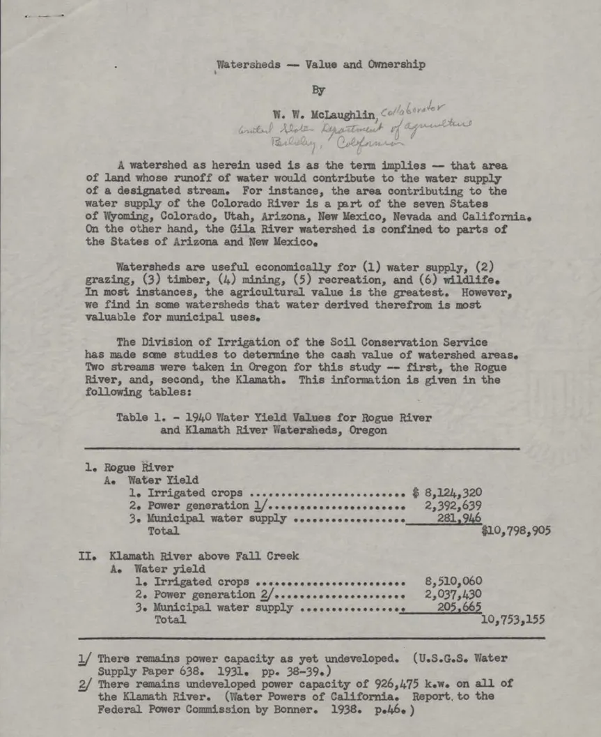
,tt2r-;-ds Value and Ownership By
• McLaughlin
A watershed as herein used is as the term implies -- that area of land whose runoff of water would contribute to the water supply of a designated stream. For instance, the area contributing to the water supply of the Colorado River is a part of the seven States
of v.yomin,;, Color. do, Utah, Arizona, New Sexico, Nevada and California. On the other hand, the Gila River watershed is confined to parts of the States of ,rizona and New Mexico,
latersheds are useful economically for (1) water supply, (2)
grazing, (3) timber, (4) mining, (5) recreation, and (6) wildlife.
In most instances, the agricultura value is the greatest. However, we find in sem watersheds that water derived therefrom is most valuable for municipal uses.
The Division of Irrii:Ation of the Soil Conservation Service has made same studies to determine the cash value of watershed areas. Two streams were taken in Oregon for this study -- first, the Rogue River, and, second, the Klamath. This information is given in the following tables:
Table 1. - 1940 ater Yield Values for Wipe River
and Klamath River ;,atersheds,
Oregon
1. Rogue River
ito ater Yield
1. Irrigated crops $ 8,124,320
2. Power generation 1.1 ...***** 2,392,639
3.
Municipal water supply . ...***** 28W46Total
$10,798,905
U. Klamath
River above Fall Creek A.Water yield
1. Irrigated crops ...******* ... 8,510,060
2.
Power
generation ******...
2,037,4303. IdurticipLa
water supply 205,665Total 10,753,155
2./ There remains power capacity as yet undeveloped. (U.S.G.S.'Later Supply Paper 638. 1931. pp. 38-39.)
..21 There remains undeveloped power capacity of 926,475 k.w. on all of the
Klammtk
River. (ater Powers of California. Report to the Federal Power Commission by Bonner. 1938. p.46. )- 2
Table 2. - The 1940 'aster Yield Value per Acre of Rogue
River and Klamath River i.atersheds„ Oregon
: :
Stream : ;atershed : 1940 value per
basin : area, : acre for Factor
acres : A alone
Rogue River Klamath River
2,624,000 ie 4.12
2,784,000 3.86
These to matersheds have approximately the same area, and the value
for irrigation is about the same as is also the value of power developed. The value of irrigated crops is based upon the price received by the farmers and is not the price to the consumer. On the other hand, the
power value is determined by the receipts of the power companies from the sale of power. The value to a municipality is determined by the receipts of the municipalities for water delivered to its users. These values are all on the basis of prices of 1940 and represent annual rates.
find on the Rogue River that the annual per acre value for the water-shed based upon water yield for irrigation, power, and municipal use is 44.12 and on the Klamath, $3.86. If we put a per-acre capital value on the watershed lands determined by the water yield value, it is approxi-mately 6100 for each and every acre of the watershed. A study was made in the Salt River Valley of Arizona, and there the agricultural value alone was approximately $7 annwilly. The Poudre River watershed in Colorado has about the same value as the Oregon watersheds studied. Additional studies have been made to determine the values of watersheds in varier.: parts of the West, but the war prevented collection of these data in detail. They will show values for recreation in addition to agriculture, mining, etc.
From time to time bills are introduced in Congress and agitation appears in States for the surrender of public lands under Federal con-trol to the States in which these lands are situated. The watershed lands are mined in most instances by the FedPral Government. In other cases they may be owned jointly by the Federal Government, the State and private interests. There are several instances in the West where
small watershed lands have been acquired by (1) municipalities, and
(2) by irrigators. It would seem axiomatic in these Western States, where water is the life-blood of the country that ownership and con-trol of the watersheds are of vital importance to water users. The management of a watershed for its various uses, together with the conservation of that watershed as such, is as vitally important as
-
3
-and, we had better say, over-use and abuse of watersheds. The question then arises -- hov, can these areas be utilized, pro-tected and policed?
In most States, according to my way of thinking, there are only two practical metoda -- first, by the Federal Government, and, second, by the Federal Government with the cooperation of all land owners within the waLarshed. A question of financing this control and policing has been a subject of much debate. It would seem that where the lands are owned almost entirely by the Federal Government, then it should do the policing. The cost of this policing might be derived from the sale of the products of the watershed wholly or in part; or, as many contend, it should become a function of the Government without a charge for water used in agriculture.
I am simply bringing out the question of watershed ownership management and control that we may all think about it and be ready to evolve a workable and practical program. In talking of the
control of watersheds
and
maw of securing funds for that controlsit is realized that the charge canliot be made to appropriators of water for the water. It is possible, however, to make a charge for policing a water supply; and, while there might be difficulty in collecting (unless there is created an overall district), yet it is a field worthy of investigation. To let extensive watershed lands pass into private ownership would be a vital mistake as I
view the question.
Berkeley, Calif.
April 16, 1947
COLORADO RIVER WATER FORECAST COMMITTEE
There are several ways to estimate the flow of the Colorado
River for the calendar year 1947. One way is to assume a simple
pro-portion such that - the 1947 run-off is to be 1946 run-off as the
October to March 1947 precipitation is to the October to March 1946
precipitation. The method is simple and quick and is useful as a first
crude forecast. In this method no use is made of data preceding the
last year or so.
An easy and better way is to represent the functional relation
between the run-off and precipitation by the simple linear regression
equation X1 = a + b2 X2 where X1 represents the run-off for the
calendar year, and X2 represents the total precipitation from October
to March of the calendar year under consideration. There are as many
equations as there are years of recor,d and since there are more
equa-tions than unknown coefficients, such values must be found for (a) and
(b) so that a single equation will most nearly represent the yearly
relation between precipitation and run-off. These values are obtained
by the method of least squares. X1 is called the dependent variable
and X2 is the independent variable. When the best values for (a) and
(b) have been found it is a simple matter to put the actual value of
the precipitation in place of X2 and at once solve for X1, the run-off
for the calendar year 1947.
A still better method is to represent the run-off as a
function of several independent variables in what is called a linear
multiple regression equation as for example:
X1 = a + b2 X2 + b3
x3 +
b4
+ b5
x5 + b6 x6
-1-where X
1
is still the dependent variable, and all the other X's are
independent variables.
This problem can be approached in a number of different wayso
One way would be to let each of the five independent variables
rep-resent the October to March precipitation at each of the five
corresponding stations. Letting X1 represent the run-off of the
Colorado River near Grand Canyon for each of the calendar years from
1923 to 1946, we will have 24 simultaneous equations for which we
must get the best values for each of the six constants, Again, this
Is done by least squares, From this equation the 1947 run-off can
now be estimated by placing in the equation the actual values of
the October to March precipitation totals at each of the five stations.
The partial (or net) regression coefficients bn determine
the weight or importance of each station's contribution to the
estimate, By means of this equation we estimate the annual run-off
for each year of record and from these estimates we can establish a
multiple correlation coefficient. This coefficient has to be corrected
for six degrees of freedom because there are six constants in the
regression equation, From the estimated values for each year and
the actual run-off can be obtained the standard error of estimate°
From the unadjusted multiple correlation coefficient can be obtained
the value (t) which is used in tests for significance, when the
records are short,
Instead of lumping together the precipitation from October
to March we can set up a linear multiple regression equation:
where X
2
represents the unweighted sum of the October precipitation
records at the five chosen stations, x3 represents the sum of the
November precipitation records at all of the five stations, and so on
for each of the months up to March. As before we obtain the best
values for the seven constants by least squares, With this regression
equation we now make as
of record and from this
correlation coefficient
and the value (t). The
many estimates of ran-off as there are years
data we will be able to get our multiple
as well as the standard error of estimate
correlation coefficient has to be adjusted
for
seven degrees of freedom. With this multiple regression equation
a forecast can be made by putting the actual values of precipitation
in the equation and solving for the run-off. If only October to
March records are used any number of stations can be used without
increasing the number of degrees of freedom.
Although it is possible to make either the months of
precip-itation or the stations independent variables, it is also possible to
make the run-off dependent upon both months and stations separately,
yet with a record of only 24 years there would be too many independent
variables for the correlation to have much significance.
Still another method of attack will now be briefly described
which I think is quite new, Instead of setting up a multiple regression
equation for the actual run-off and the actual precipitation, the
equation is set up for the first differences of the original data of
the run-off and the first differences of the precipitation.
After the constants have been determined by least squares as
before, an equation will be formed by which the first differences
can be estimated for each year of record, From these estimates as
before can be obtained the multiple correlation coefficient as well
as standard error of estimate and a value for (t).
-1-With this equation an estimated first difference between the
1947 and the 1946 run-off can be estimated. This first difference
added to the actual 1946 run-off will give the forecast run-off for
1947.
In the first meeting of this forecast committee I made a
forecast based upon an equation in which each month was made an
indepen-dent variable, but last year and this year I have made the first
differences of the stations the variables and not the first differences
of the individual months.
Five precipitation stations were selected by trial from the
entire watershed because their oombination gave the highest correlation.
They are Crested Butte, Delta, Mesa Verde Park, and Steamboat Springs
In Colorado, and Escalante in Utah. The linear multiple regression
equation of the
first
differences for these precipitation stations and
the run-off is
X
1
1
. _749 +
03575 x2 + .9053 X
3
+ .0136 X4 + .2162 x5 + .8896 x6
3,820,000
acre—feet.
The run-off for l946 was 9,137,000 acre-feet. The run-off for
1947 will therefore be 9,137,000 plus 3,820,000 equals 12,957,000
acre-feet. The unadjusted correlation coefficient is .8922 which when
cor-rected for
6
degrees of freedom becomes
.86.
The standard error of
estimate is plus or minus 1,193,000 acre-feet, therefore the estimate
for the run-off for the calendar year 1947 is 12,957,000 plus or minus
11193,000 acre-feet. The run-off for April to July is 8,705,000 plus
or minus 802,000 acre-feet.
By simple linear regression of the first differences an
estimate of 12,400,000 acre-feet was made for the calendar year which
would make the April to July run-off to be 8,331,000 acre-feet. The
unadjusted simple correlation was
.8476.
By the simple proportion method the calendar estimate was
11,851,000 acre-feet, and for the April to July period is 7,962,000
acre-feet.
One advantage of using first differences instead of the
actual run-off and precipitation data is that the various trends are
practically eliminated by the process. Invariably a higher
correlation was obtained between first differences than between the
original data from which the first differences were obtained.
With the same selected stations the forecast can be made much
better when the April precipitation is included, for with the October
to April precipitation we get an unadjusted multiple correlation
coefficient of .9360 which when adjusted for
6
degrees of freedom
becomes
.9151,
which is still pretty high.
In calculating the simple correlations between the Colorado
River near Grand Canyon and its separate tributaries, an astonishing
discovery was made that the Gunnison River has the extraordinary
correlation of
.9587
although the Gunnison contributes only 14.70%
of the total run-off.
This fact might suggest that it should be possible by means
of precipitation records taken only at stations in and immediately
surrounding the Gunnison watershed, to obtain a very high correlation
with the run-off near Grand Canyon.
Another method of estimating the flow of the Colorado River
near Grand Canyon is by means of the run-off for the month of May only.
It has a simple correlation coefficient of .9119. May combined with
June, unweighted brings this up to .9490 while with July added brings
the correlation to
.9684.
This is higher than from April to July,
which is
.9642.
5-Another way to get better results is to use curvilinear
regressions with precipitation and run-off. Perhaps the best method
of all would be joint correlation if enough data were available.
The magnitude of correlation is no criterion for the selection
of stations whose combination will give the best correlation. The
combination of two low correlating stations may have a higher
correla-tion than the combinacorrela-tion of two high correlating stacorrela-tions.
After much work has been done in developing a combination of
records with a high correlation it sometimes happens that one or more
of the best stations are discontinued, such as Dolores and Sapinero.
This is unfortunate, Cannot something be done to perpetuate the
stations with the longest records?
It is important to do away as much as possible with the
personal factor in making estimates. Also it is more important to
arrive at an accurate early prediction than an easy less reliable
method.
HLT/RC
-6
4-16-47
DEPARTMENT OF WATER & POWER
CITY OF LOS ANGELES
RESEARCH AND RECORDS SECTION
OPERATING DIVISION
Memo To: Mr. Charles E. Kochl
Subject. COLORADO RIVER AND ITS TRIBUTATIES
RUN-OFF IN PERCENTAGE OF FLOW AT BRIGHT ANGEL CREEK ARIZONA Colorado River M4n Stem
Near Grand Lake, Colo. Near Granby, Colo.
At Hot Sulphur Springs, Colo. Near Kremmling, Colo.
Neat Dotsero, Colo.
At Glenwood Springs, Colo.
Near Cameo, Colo. 1933 - 1944
Near Palisade, Colo. 1922 - 1933
At Grand Junction, Colo. (1897 - 1899) (not inc. Gunn.R.)
Near Fruita, Colo. Near Cisco, Utah
Including Green River at its mouth
Including Fremont River near Bicknell, Utah Including Escalante River at Escalante, Utah Including San Juan River at Bluff, Utah At Lee's Ferry, Arizona
Including Perla River at Lee's Ferry
Including Little Colorado River at Grand Falls, Ariz. At Bright Angel Creek, Arizona
Run-Off .44 1,76 34440 8.41 10,79 15.04 24.21 26.20 25,70 38.83 444120 77,63 78,15 78,38 94,71 96,75 96.95 98,70 100.00
Tributaries to thUgn Stem of Colorado River
Roaring Fork at Glenwood Springs, Colo, 7,24
Gunnison River near Grand Junction, Colo. 14,70
Delores River at Gateway, Colo. 6.77
Green River at its mouth 33.43
Fremont River near Bicknell, Utah .52
Escalante River near Escalante, Utah .23
San Juan River near Bluff, Utah 16.33
Perla River at Lee's Ferry, Arizona .20
Little Colorado River at Grand Falls, Arizona 1.75
Green River and its Tributaries
Green River at Green River, Wyoming 8.91
Green River near Linwood, Utah 10.17
Green River at Jensen, Utah 25.17
Green River at Greenriver, Utah 32.26
Yampa River near Maybell, Colo,
8039
Yampa River below mouth of Little Snake River 11.77
White River near Watson, Utah 4.16
Duchesne River at Myton, Utah 2,73
Uinta River at Fort Duchesne, Utah .71
Little Snake River near Lily, Colo, 3.38
Price River at Woodside, Utah 1,63
San Rafael River near Greenriver, Utah 1.17
Virgin River at Littlefield, Arizona*
*The Virgin River flows into Lake Mead
RC-8 IN CHARGE 1.70 Drainage Area In Sq. Miles 101 322 782 2,360 4,390 4,560 8,055 8,790 8,910 17,100 24,100 66,390 70,950 72,730 96,630 107,900 109,470 130,670 137,800 1,460 8,020 4,350 40,600 4,560 1,780 23,900 1,570 21,200 7,670 14,300 26,600 40,600 3,410 7,140 4,020 2,750 672 3,730 1,500 1,690 5,090 H.L.T. Apr.14, 1 9 4 7
DEPARTMENT OF WATER SA. POWER
CITY OF LOS ANGELES
Memo To:
Subject:
RESEARCH AND RECORDS SECTION
OPERATING DIVISION
Mr. Charles E. Kodil
SnMR CORRELATTONS "WITH COLORADO RIVER AT BRIGHT ANGEL CREEK, ARIZONA
There are four large branches of the Colorado River above Bright Angel Creek* Arizona: the Green River, measured at Greenriver, Utah; the main stem of the
Colorado measured near Cisco, Utah; the San Juan River measured near Bluff, Utah; and the Little Colorado River measured at Grand Falls, Arizona. The last named river is large only in the size of its drainage area* for its run-off is compar-atively small.
The Green River measured at Greenriver, Utah, contributes 32.26% of the flaw of the Colorado River at Bright Angel Creek* Arizona* and drains the southwest corner of Wyoming, the northwest corner of Colorado, and the northeast corner of
Utah. Drainage area = 40,600 square miles.
The main stem of the Colorado River measured near Cisco, Utah, contributes 44,20% of the flow of the Colorado River at Bright Angel Creek* Arizona* and
drains the central part of western Colorado. Drainage area 24,100 square miles. The San Juan River measured near Bluff, Utah, contributes 16.33% of the flow of the Colorado River at Bright Angel Creek, Arizona, and drains the southwest corner of Colorado* the Northwest corner of New Mexico, a small bit of the north-east corner of Arizona, and the southnorth-east corner of Utah. Drainage area = 23,000 square miles.
The Little Colorado River measured at Grand Falls, Arizona, contributes only 1.75% of the flow of the Colorado River at Bright Angel Creek, Arizona, even though it has a drainage area of 21,200 square miles. It drains the central part of eastern Arizona and a small part of western New Mexico.
CORRELATION COEFFICIENT IN % WITH RESPECT TO COLORADO RIVER AT BRIGHT ANGEL CREEK, ARIZONA
For period beginning For period ending
Oct. 1922
September 1942
ONWRIMI•••••MIII/11.11•1111•MINNIIIIIMIIIMOMMINO
For period ending September 1944
Green River at Greenriver, Utah 96.68 96.77
Colorado River near Cisco, Utah 98.31 98.30
San Juan River near Bluff, Utah 88,20
88.75
Green River + Colorado River near Cisco
98,54 98.61
Colo. River near Cisco + San Juan River 98.84 98.81
Colo. River near Cisco + Green R. + San Juan R. 99.31 99:33
Colorado River at Lee's Ferry, Arizona 99,90
99.91
APPROVED
Page 1
DEPARTMENT OF WATER Si. POWER
CITY OF LOS ANGELES
RESEARCH AND RECORDS SECTION
OPERATING DIVISION
Memo To: Mr. Charles E. Kodfl - Page 2
Subject:
Since there is no record of the run-off of the Little Colorado River from October 1922 to November 1925 the correlation has to be based on the record begin-ning December 1925.
For period beginning For period ending
For period ending
December 1925 September 1942
September 1944
Colorado River at Lee's Ferry, Arizona 99.93
99.93
Little Colo. River at Grand Falls, Arizona 4.75
4.57
Colo. River at Lee's Ferry + Little Colo, River 99.96
99.96
RC-8
APPROVED
IN CHARGE April 14
DEPARTMENT OF WATER & POWER
CITY OF LOS ANGELES
Memo To: Subject•
RESEARCH AND RECORDS SECTION
OPERATING DIVISION
Mr. Charles*,_Kodil
Colorado River near Grand Canyon, Arizona
Correlations between Annual Run-off and Run-off for
certain months and combinations of months.
Simple correlation for
April alone with Annual Run-off
MayII
It It itJune
Ti H itJulyit
tt
It
11
April to May
II itApril to June
II itApril to July
ttii
11
March to June
Ii ii VtMay to June
Mayto July
•MEE-6
APPROVED IN CHARGE.5792
.9119
.8383
.9098
.8564
.9390
.9642
.9455
.9490
.9684
HLT
Apri122
19
k7
1SOME CORRELATIONS WITH COLORADO RIVER
NEAR GRAND CANYON,* ARIZONA
There are four large branches of the Colorado River above Bright Angel Creek, Arizona:
the Green River, measured at Greenriver, Utah; the main stem of the Colorado, measured near
Cisco, Utah; the San Juan River measured near Bluff, Utah; and the Little Colorado River
measured at Grand Falls, Arizona. The last named river is large only in the size of its
drainage area, for its run-off is comparatively small.
The Green River measured at Greenriver, 'Utah, contributed 32.26% of the flow of the
Colorado River at Bright Angel Creek, Arizona, and drains the southwest corner of Wyoming, the
northwest corner of Colorado, and the northeast corner of Utah. Drainage area = 40,600 square
miles.
The main stem of the Colorado River measured near Cisco, Utah, contributes 44.20i9 of
the flow of the Colorado River at Bright Angel Creek, Arizona, and drains the central part of
western Colorado. Drainage area
24,100 square miles.
The San Juan River measured near Bluff, Utah, contributes 16.33% of the flow of the
Colorado River at Bright Angel Creek, Arizona, and drains the southwest corner of Colorado,
the northwest corner of New Mexico, a small bit of the northeast corner of Arizona, and the
southeast corner of Utah. Drainage area = 23,000 square miles.
The Little Colorado River measured at Grand Falls, Arizona, contributes only 1.75%
of the flow of the Colorado River at Bright Angel Creek, Arizona, even though it has a
drain-age area of 21,200 square miles. It drains the central part of eastern Arizona and a small
part of western New Mexico.
COLORADO RIVER - MAIN STEM
Colorado
Colorado
Colorado
Colorado
Colorado
Colorado
Colorado
Colorado
CORRELATION COEFFICIENTS IN %
WITH RESPECT TO
COLORADO RIVER NEAR GRAND CANYON
t ARIZONA
River at Glenwood Springs, Colo.
River near Palisade, Colo.
River near Cisco, Utah
River below Green River
River below San Juan River
River at Lee's Ferry, Ariz.
River below Little Colo, River
River near Grand Canyon, Ariz.
COLORADO RIVER TRIBUTARIES
Dolores River at Gateway, Colo.
Duchesne River at Myton, Utah
Green River at Greenriver, Utah
Green River from Utah only,**
above Greenriver, Utah.
Green River at Green River, Wyo.
Green River near Linwood, Utah
Gunnison River near Grand Junction, Colo.
Little Colorado River at Grand Falls, Ariz.
Roaring Fork at Glenwood Springs, Colo.
San Juan River near Bluff, Utah
Virgin River*** at Littlefield, Ariz.
White River near Watson, Utah
Yampa River below the Little Snake River
Corr.
Run-off
;A_
77.16
15.0
83.62
26.20
98.30
44.20
98.61
77.63
99.33
94.71
99.91
96.75
99.96
98.70
100.00
100.00
88.11
81.81
96.77
83.57
77.13
71.80
95.87
4.57
87.07
88.75
85.78
74.30
81.96
6.77
2.73
32.26
6.16
8.91
10.17
14.70
1.75
7.24
16.33
1.70
4.16
11.77
Drainage
Sa. Miles
4,560
8,790
24,100
66,390
96,630
107,900
129,100
137,800
4,35o
2,750
4o 1600
15,14o
7,670
14,300
8,020
21,200
1,460
23,000
5,090
4,020
7,140
Drainage
a
a____
3.31
6.38
17.49
48.18
70.12
78.30
93.69
100.00
3.16
2.00
29.46
10.99
5.57
10.38
5.82
15.38
1.06
16.69
3.69
2.92
5.18
Formerly called "at Bright Angel Creek"
**
Green R. at Greenriver, U. minus the Yampa R. below the Little Snake, minus the White R.
near Watson, U. and minus the Green River near Linwood, U.
***
The Virgin River flows directly into Lake Mead.
April 22, 1947
Mr. R. L. Parshall,
Senior Irrigation Engineer, Fort Collins, Colorado
Dear Mr. Parshall:
After I read my paper at the forecast meeting of April 16, 1947, one of Mr. Vetter's men came to me and asked how I weighted my data. Some perhaps do not consider the net regression coefficients as weights, but they really are, as is so well expressed by Prof. F. C. Mills in his book "Statistical Methods* speaking of net regression coefficients, "They indicate the weight to be attached to each of the independent vari-ables," page 504, 1924 edition.
On the bottom of page 2 and the tope of page
3
Ireferred to the ordinary sense of weighting. In order to clear up any ambiguity on weighting and to correct a number of typographical mistakes I am sending you a corrected copy of my paper.
I am not ignorant of the fact that our record at Bright Angel is rather short to be used in establishing a muliple regression equation, in fact just above the border line of being justifiable or not. However, I have stuck to the Bright Angel record because it most accurately represents the inflow to Lake Mead, and also more precipitation records are available for that shorter period.
Wishing you the best of health and hoping to see you again next year, I remain
Cordially yours,
P.S. My apology for corrections is that I wrote my paper in a hurry, finishing it at 1:30 A.M. April 16, and had it typed in the morning just a few minutes before the fore-cast program began.
3
74.78 •
rei7
e )/
•
-wyyy /
'
9
c--Ney)
Water stored in snow throughout Nevada and the Eastern sierra is below average on 97 percent of the 94 snow courses meas-ured about April 1.
Forecast of runoff for the 1947 irrigation season ranges from about 30 to 60 percent of average. Throughout the main
Hum-boldt River Basin the ran off will be about 40 percent of nor-mal. Little Humboldt River Basin will discharge about 30 per
cent of normal. Lake Tahoe will not fill unless above average
"40,eY0
precipitation occurs during the summer 40 01 • eason. Truckee
River will also discharge about 60 percent of normal,
meas-ured at Farad. Carson River will ;e about 45 percent
of norma measured near Ft. Churchill. West ':ralker River
will about 40 percent of normal, measured near
Cole-ville, while East - alker will flaw about 60 percent of normal
measured near Bridgeport.
Reservoir stora4e is good throughout the state, with the April
1 contents about 80 percent of capacity. Melting snow on the
higher elevations will increase storage to about 90 percent
4.
SNON ANP.XNUF APRIL L6, 1947
ARIZONA
The past seasons snow pack throw7hout the higher elevations
of Arizona was near a record law. Precipitation, which had
been abnormal early in the water year, was very short after
January 1. Runoff started the water year at extreme highs
thraughout many of the basins, but with a poor snow pack to
draw upon the streams slowly decreased in volume. The present a
444. gitmoa.N...44
outlook for irrigation season is lor about 30 percent
A
normal supplies i the Gila River south and about 40
per-4.6g
cent 7 the Salt River north. Reservoir storap7e is
extreme-ly poor. The AT;ril 1, 1947 storage is onextreme-ly 15 percent of
ca-pacity. Lake Yead contained 60 percent of the storage capacity
Cow
cek-Go-tirk
z
Utah Snow Conditions on the Colorado River D. K. Fuhriman
The prospective water supply for the Utah areas in the eolorado River drainage is good, imetir. speaking in general terms. However, there are some watersheds in this drainage which will yield deficient supplies during the coming season.
Along the upper reaches of Utah's tributary area, north of the Uinta
mountains, the snow cover is slightly above the average at the higher elevations although the low elevation cover melted early. Runoff from Blacks 2ork, Henry's Fork, Burnt Fork and Beaver Creek on the upper Green hiver system should be about normal with supplies holding up well during late summer. On Ashley and Brush Creeks to the South, near Vernal, the snow cover is also somewhat above normal at the higher elevations and is eassama=ttmes otter than in 1946.
f
rOMASnow cover on the Duchesne River generally is fairly high. The runoff ixt
-Fa o
this stream should be somewhat above average. Above Faitri-ona, the snow cover
is about equal to the average, while on the Ui4tal Whiterocks and btrawberry Rivers, snow cover is 10 to 30 percent higher than the average. All of these streams
snot"(
have an excellent high-elevationAcover, thus assuring a well-sustained runoff for late season use, but early melting of low elevation snow reduces the probability of high early spring runoff.
The ?rice River drainage presents the darkest outlook of any area of the state. bnow cover here is below the normal and runoff is expected to be only 70 percent oCthe ;.0-year average. Storage in the Scofield Reservoir is considerably below
ML.
On the San Rafael, the snow cover at the head of Huntington Creek is found to be slightly below average at this time while .that on Cottonwood Creek is slightly better.
In ,
Snow oe-tne Escalante area is slightly below normals hlowever, the runoff should be about equal to the average because of heavy priming of the
w a 4411
watersheds ell moisture.
The Virgin River snow cover is slightly below normal, but considerably better than that of a year ago. hunoff should equal about 80 percent of the average.
'on
On the Lower Colorado,AMoah and Monticello areas, recent snow surveys
.erui
indicate that the runoff will be approximately 80 percent of the normal, madr
btimf: than a year ago.
441°
Most of the watersheds of the state were subjected to heavy rain last fall, thus priming the soil and assuring a rather high percentage of
yield to be expected from this year's snow cover. Considerable melting of low elevation snow cover has occurred but it is believed that most of this yield will appear during the cop4pg April—September period.
AI
-Suow-Conditions in Colorado, Wyoming and New Mexico
Iiir....440.44bel-1: Snow cover on the headwaters of the Colorado River and its
tributaries in Colorado, as shown by sn w surveys April 1? is well above
b6A. ¶4 tv"At.ek* e/46' 4.4400.
normal and 1746. However, the water supply situation on streams
originating in southwestern Colorado is not so av rable.. The snow cover
/\...trAJ ey&f,144.4
in this area is on the frOgekocithe drough du:A
-VA-4 4-LANI im%b
/fury"- -3-v4.440-0 4w,,,*.t.isout1
ook /1k percent of normal.'. The flow of th
.?"141
AdYCLA• °
an,
probably be near normal but timmilhommgc the San Juan and Dolores itiverS444k1/wiw,
bAN
be decidedly deficient. Recent precipitation has ranged from above normal in
northern Colorado, to a definite deficiency in southern olorado and =akin'
northern New Mexico.
Tile water rvJ,,
twar-k-suit imasfswill
Snow at high elevations on the Green River watershed in Wyoming has
cAmtpt
014 AA
titittil
increased very little during Marc and the estimatesAOPI-Vamer...414011011)
4bissmammihrreelpobs about 95 percent of last year's flow. Seasonal precipitation
iesekht3 0.6Aet:nees el+1 dOVI
has been well above normal over tUla watershed but -peeen-t-preekkitaptiipos has
been slightly deficient. The discharge of the Green during the April-July
period will be near average.
Snow cover is above normal on the Yampa, White, Colorado (rIVIiofr"
Roaring Fork, Gunnison and Oncompaghre Rivers. The snow is relatively
heavier near the Continental Divide.
D.<
1.cz
A
1-rt
• I ee). • ' 4 .ed04,4„
, * ,:,„„<"
,
.4 /
11.1-
4
r
kwe
ti. 5/4f-cord
a,
, 04
4/
co;
/ Zo-see_ y
c Vr, "tar
us..
C-4--eAt4"-rop.n/.*-ss 27e.,/, pi 7
7
i7044147- pi
Ve,
r
j-s we, a 71
r
e
61\
1
A%
4,
Ai d
RAfie:
94
'
)
-`
/-taa
/4
10(
A
yz)
.7431
eid
42 0 6 t11-&--A-7r7e.ci7
ti;r1
Vkl, a,
/7"cci4s-n4 is or? U5 , SO,I•Co
I
De47,ti--P441‹.,
7
,
-2,4-44,6ex-ex,
4,67c-
cZy
,
e41,
/-7)r- r
0,/
e(e_
4ia
// ;4.
-64
i
6/e vt
3ouidee i1 i Nev
ea,
SroPeY
CALIF.
/O1 Kii/EFxr-
/liohnolci-
_I-4,24;1, a,
5, C.
D.
( 7 1 I 3 4 e Pt0. .5. E. 0 (.
L
A 1\14/Carp ENkcl tpeers(4
Eu--i-i)
fillig-/
/
460..e.t.74 7/opcyc4"-e/2„...
a
)t ' C--411*-Ly )9-(A--e.N"A.-LT:-,, ,), i
4.:...;,4 L/ 6i,
6',.:s ii
g,—../ /7- -
7L,
,_ I
6 / -(-6-'- • A.-- . L . oN it r• '
/ (h).114.„/,.. 14 (:),w4 63 i;
.,, ,.,,efi k---
(
T;;;Li .‘-'.-allti.:, (
.... ,
,
7 ---
.
A. /4,, e) , I '‘ ( 61 / r A ' rf ( / 4
'-7
- - C' - . . •I 6) -,
1'
,W
, -
'
,/
u
f f /26/ —"e,.."4 "... ,r:? /1,0606,i,
,,,,, .41)4_,'
t ERA,C.act
C.44 w.41.ocs-11/ .10.0.11M1111.M...
ao-eet4-1-0
Re-ryr /4
a
/4-/9
0.71k0441 fiv14440
R4,A1,0,-a
.2s? aztayce6.,..e
41/I j
g (ke&-ti.
•
1::
3-r441,
/
6 6
60s
3boo
c-
//
o
c)
,5-Y97
czba_
Y
r3o
0
-(44,
Utility of Snow Surveys in Colorado by
R. L. Parshall, Senior Irrigation Lngineer
U. S. Department of Agriculture, Soil Conservation Service Division of Irrigation
Fort Collins, Colorado
Snow Surveys and the forecasting of runoff in the several main
drainages in Colorado concern a work that has been carried on continuous— ly since its inception in 1936. From the crest of the Continental Divide, north and south from the state lines of Wyoming to New Mexico, the snow melt feeds the streams that flow down to the fertile valleys to the East and West. Since the start of irrigation throughthut Colorado in the early 60's land development has steadily advanced and now reached the point where virtually all irrigable areas are served to the limit of water supply. The success of crop production in these areas, where irrigation is practiced, depends directly upon the extent of the supply.
Perhaps one is inclined to the conclusion that the value of the crop on the farm is the principal and end result of the use of water. Yes, this is essentially correct but not the complete story. In
reflection we recognize that the existence of mankind depends wholly upon products of the soil directly or indirectly and without water the subsistence from the land would be naught. This production of food from the soil is the primary gain to the farmer but through the sale of his crops an avalanche of business transactions results. Might it not then be said that this secondary reaction overshadows the initial release of the products from the farm that was made possible from and through the practice of irrigation. Let us consider the single crop of sugar beets as produced in Colorado, which of course would fit the picture elsewhere.
-2-The grower has an outlay of expense from planting time to harvest, constituting wages, equipment, supplies and other charges which in the aggregate is a stimulus to business in many lines. The effect of cash settlement for the crop after harvest where several million doulars accumulate in a single community has a very marked effect in all lines of business of the town or city - the center of the surrounding
agricultural area. The dollar to the farmer for his crops has back of it many indirect profits which total far in excess this initial return.
What is the role that Snow Surveys play in this great drama? For Colorado it is perhaps much the same as found in al] areas where stream flow is diverted to water the fields to produce wealth. Firs4 it may be assumed, without question, that the part played by SnovSurveys is
14 1446(k
important ane-woodowel the end result of this work is of benefit to all .)
tiokArktikt
concerned with waterthe vital attribute of our prosperity and existence. How can the utility of forecasting water supplies be reduced to a dollar basis? The value of such advanced information to an individual or group of water users should direct the judgment to the successful seasonal outcome of production. The practice of irrigated farming far precedes the measurement of snow as a means of forecasting water supplies. However, since the inception of this work, added assurance in farming has resulted but, because of the temperamental element of weather which enters into this matter, positive statements cannot always be made covering the forecasts
()Ocoee castro
of stream flow in Colorado. The compositepicture
A
is made up of variousfactors of which the principal one is the water held in snow storage in
at
so
the mountains. Due consideration is given to the amount of water in storage 11/4
-3--Also, soil moisture throughout the farming area is considered in the statement having to do with the adequacy of the supply for the coming season. The fali stream flow from the mountains is taken as an index of the ground water storage on the drainage area which produces the runoff from the melting snow, and further the characteristics of individual water-sheds differ and in this it is believed that the deep narrow basin is more productive from the standpoint of runoff than for one which is broad and shallow. Other factors are also involved.
It can be said without contradiction that the snow surveys made and the findings reported each month fill a useful place in the agricultural and business activities of our state. The results of this work must surely give assurance to those who produce the wealth from the soil and as has been mentioned the values from the farm bear directly upon the welfare of the State and Nation. As a general statement, not based on statistical facts, it could be said that the one dollar to the farmer means at least five more dollars gain in the spending of his money. Some authorities give a ratio of seven to one. At any rate, whatever the ratio, we can conclude that when the farmer prospers, likewise all business. It is not the intention here to become involved in agricultural statistics. The question in mind is, what part of that one dollar the farmer spent should be credited to snow survey information? It is a mere conjecture in assuming that on the average the farmer may have benefited by one cent. At this apparent ratio of but one percent the ultimate benefit accruing to all business and industry is a large figure indeed and far overshadows the cost of conducting the snow survey work. In fairness to the question
-4-both sides must be considered. Forecasts may sometimes be erroneous to the extent of material injury instead of being beneficial. Relatively close predictions are for years where more or less normal precipitation prevails subsequent to the time of forecasting, say April first. Should the remainder of the spring months and early summer suffer a period of sub-normal rainfall then deficiencies in water supply will result. Science has not advanced to the point where future conditions of weather can be known. When it becomes possible to circumvent or out-guess the weather, the water supply forecaster will occupy a notable place in the affairs of the world.
U111,121 OF eN04; 6URVEYL;1i duLliNG G. Bishop State ebgineer
UT (L.
cry taeeruZtili24tRiini()QvEysINwf0n4 IN6
47 L•
stow
SURUYS ITWYuMiGAPIA1—E4-
1947-The first snow courses were established in Wyoming the fall of
1935
by George D. Clyde and R. L. Parshall. The first surveys were made February 1936.
Additional courses have since been established until 41 are now in operation.
From these courses, either individually or in combination, the forecast curves for the following main streams and tributaries are made up:
Green River at Linwood, Utah. Based on courses in vicinity of Big Piney, Pinedale and Boulder. Flow records at these stations are important.
About one tenth of the water reaching Bright Angel Station on the lower Colorado passes Linwood.
Yellowstone River at Corwin Springs, Montana, is based on snow survey records on course in the Park and adjacent drainages. Snow records are important here from the standpoint of floods as well as water supply for irrigation in the lower vafley.
North Platte River at Saratoga. Forecasts are based on several courses, located on Cameron, Willow Creek and Rabbit Ears Passes, and other places in the North Park area. These records are important in predicting the water supply for the four main storage reservoirs on the North Platte River in Wyoming. The irrigated areas in eastern Wyoming and western Nebraska benefit from forecasts basedlion the snow cover of this water shed.
Shoshone River at Cody. The Sylvan Pass course in the Yelloe stone Park is basic in forecasting the water supply for irrigation in the Powell District and elsewhere along the Shoshone Valley.
Wind River at Riverton. Ten courses are located on this water shed which is used in forecasting the summer runoff both for reservoir storage and ex-tensive irrigated areas along the Valley of the Wind and Big Horn Rivers. At Brooks Lake,„pne of the best courses in the state is ,located. This course
is near Tatoiat ge"Pcgt. The courses on the water shed of the Pptio Agie
are proving valuable in forecasting the runoff An this stream.
Laramie River at Jelm. Cameron Pass and Chambers Lake Course, together with others form a good combination in forecasting a runoff in this stream. This is important for the water users under the Wheatland Reservoir, and others who have irrigation water rights from the Laramie River.
April g, 1947
Sweetwater at Alcove* Based on Grannier Meadows Course is valuable in forecasting inflow for Pathfinder 7eservoir and the water supply for the entire North Platte Valley in Wyoming.
Investigations are in process correlating runoff to snow cover on the
Powder, Tongue, Encampment and Cheyenne Rivers and Big Creek as well
as other streams.
Snow survey records in Wyoming have proved useful in providing current
information on the amount of water in snow storage on the main water
sheds. Snow survey reports are valuable to all of the irrigators in
Wyoming because the source of their water supply is on the high
platea-:s and mountain ranges.
Monthly reports of these snow surveys are issued by the Division of
Irrigation of the Soil Conservation at Fort Collins, Colorado.
The Field Surveys are made largely by the IL S. Forest Supervisors
and
Rangers,
and National Park personnel. There are several independentobservers, however, and our office is the principal fiancial cooperator.
Others lending assistance are the IL S. Bureau of Reclamation and the
principle Irrigation Districts in Wyoming. The work is directed by
the Division of Irrigation of the Soil Conservation Service, through
George D. Clyde, Chief of the Division at Logan, Utah, and R. A. Work
Supervisor of the Snow SurveysProject carried on cooperatively through.
out the western mountainEtates.
LA
Our contacts have been principally with Mr. R.
4.
Parshall, SeniorIrrigation Engineer who has been most cooperative at all times.
UTILITY OF SNOW SURVEYS IN NEW MEXICO
L1.4 )0101,V% i"Ak 1311 Li
344
uyv
The first snow courses in New Mexico were established in the fell of 1936 by the Soil Conservation Service and the first
measurements of these courses were taken in February of the following year. Additional courses have been added from time
to time srp, that at present there are nineteen courses regularly
surveyed in the state. These stations together with ten
curses
on the headwaters of the interstate streams in Clorado are used in forcasting the runoffs of the various streamYsystems of the state.
The forecasts for the Rio Grande basin have generally
been satisfactory to date,
as
have those in the San Juan Basin.The estimates for the Canadian and Pecos are based on a limited number of snow courses and the correlation of snow data with runoff has not been as accurate as desirable. Readjustment of snow courses and better methods of correlation will probably im-prove future forcasts.
The early 1946 season snow forecasts for New Mexico in-dicated that precipitation and snow cover over the entire state was generally deficient and that, unless late snows improved the situation, runoff in the various stream systems would be well below normal. As the March and April data became available the dark picture of drought was confirmed.
The surveys indicated that Pecos and Rio Grande runoff from snow cover would be about a third that of the preceding ten year average. The situation on the east slope of the Rockies in the Canadian River basin was much the same. Soil conditions were fair to poor and an early light runoff was indicated. In the San Juan river drainage basin the water supply outlook was somewhat better, tho well below the average. The Gila River basin outlook was alarming. In addition to a very deficient snow cover on the headwaters and only fair to poor soil mois-ture conditions, storage in the San Carlos reservoir in Arizona was reduced to 15,000 acre feet compared to 123,000 acre feet in storage at the same date a year previous.
New Mexico reservoir storage was, in general, as deficient as the indicated runoffs. As of the first of May 1946, Elephant Butte Project storage was down to less than 1,200,000 acre feet. Although this quantity represented more than enough water for the 1946 season, the subnormal spring runoff foreshadowed a pot-entially serious situation for the 1947 season. By the first of May, it was evident that El Vado reservoir, which is the sole storage supply for 80,000 acres in the middle Rio Grande valley, would be no more than three-fourths filled. Carlsbad Project storage in Alamogordo, McMillan and Avalon reservoirs, totalled only 8,000 acre feet, or only an eighth of the average supply.
The quantities in other reservoirs of the state, excepting for local vari-ations, indicated the same deficient water supplies for the 1946 season.
As a result of the forecasts, crop aoreages were curtailed in most irrigated areas of the state and, to some extent, the longer season crops were reduced or eliminated. It is difficult to evaluate the dollars and cents benefit of the runoff forecasts to the farmers of the state. For one thing, potential damage varied considerably in various basins.
In the middle Rio Grande basin, the deficient supply to the Conserv-ancy District was further limited by the operation of the Rio Grande Compact. With only the top 50,000 acre feet of storage oapacity in El Tad° Reservoir debit-free, the New Mexico Commissioner had requested and the Texae Commissioner had granted the release of debit water (in effect, Elephant Butte Project water
stored in El "fade) to the 90,000 acre foot capacity. As a result, reservoir water
for the district was erhausted shortly after the first week of July. Timely period-ic rains after that date did much to relieve a crop loss whperiod-ich at one time threat-ened to be as great as $2,000,000. The situation was also partly relieved by the installation of a considerable number of pumps thruout the area. No estimate has been made of the reduction in crop losses directly attributable to the snow survey forecasts.
The water supply for the Elephant Butte Project was ample for the 1946 season. However, the threat of a deficient supply in 1947 caused the reduction of the seasonal release to well below the normal 790,000 acre feet set by the compact, whereas it had averaged over 80,000 acre feet per year in excess of the normal for the preceding three years.
Discharges in the Gila River basin were extremely low in 1946, being less than 50% of normal. Irrigation in the Virden Valley, which lies just above the state line and is the eastern extension of the Duncan Valley in Arizona, is further limited by the operation of the Gila River decree, which allows irrigation in the
Duncan and Safford valleys above San Csrlos reservoir only at the times and in the quantities by which that storage is increased by flows in the stream. To offset this restriction, a number of wells have been drilled in the valley' to supplement the surface flow. Knowing the deficiency to be exptected during the irrigation season the cropped acreage was radically reduced, thereby
diminishing otherwise large planting and seed losses. The savings in crop losses in this one small valley, tho small in total, were a considerable item to the farmers.
The water supply in the San Juan River basin, excepting for the small La Plata River acreage, is generally ample in all but the driest years. No attempt has been made to wvnluate savings to the farmers resulting from reduction in
cropped areas in this basin.
The Pecos River basin probably suffered as much as any area of the sUte bemuse of the drought. The Carlsbad Project with a very deficient storage supply and poor ground water conditions was severely affected. Mr. T. B. Mamas, acting superintendent of the project has made the following report on crop conditions:
"The runoff predictions for 1946 were directly res-ponsible for curtailment of acreage planted and re-sulted in all alfalfa stands suitable for a seed crop to be left uncut for a seed harvest. It alsonsulted in the planting of quick maturing crops such as small grains, forage cropsotc.,which would mature from the limited supply of water available. The value of the
matured (*real and began i crops was $145,900, t-nxi the
alfalfa seed crop value was $131,900 or a total of $277,800. The cropped acreage was reduced from a proh-ble 25,000 acres to 19,800 acres actually planted."
With these data, it is possible to make an estimate of the vtiu,3 of the forecasts to the project. Assuming that monetary loss to thl farmers on the above acreage would have been ten percent of the value of the crops grown, had the fields been planted to the usual crops, the money sevtd would have approximated $211,000. The money which might otherwiee have be in lost had the uncropped 5,000 acres been prepared and seeded, may have been as hie as
20,000. In other words, the knowledge of the deficient 1946 runoff of the Pecos may have saved the farmers &much as $3.00 to $3.50 in actual cash out-lay for each acre where the usual irrigation practice was altlred or stopned entirely. Other benefits not readily evaluated, will probably double the above indicated value of the snow forecasting service to the project.
In this paper, it would have been a much more pleasant job, to have told of the increased revenues to New Mexico farmers, resulting from a klowledge of greater than normal water supplies to be expected for the 1946 season. The value of the service is unquestioned, however, in evaluating the saow covcr data and passing that knowledge on to the water consumer whether it be for pod or for ill.
Mar 20 194,
State Ei8ere Office, 41*.Mp
)5,,ta Fe, xico.