Scientific Press International Limited
Water Resources Projects in Iraq, Irrigation
Projects on Tigris River Tributaries
Mukhalad Abdullah1, Nadhir Al-Ansari2 and Jan Laue3
Abstract
There are five tributaries feeding Tigris River inside Iraq, on these many large and small projects were developed. Two kinds of projects can be distinguished, first the projects of complementary irrigation or semi-rain feed area for agriculture, and example of these projects is Kirkuk, Hawija, Eski-Kalak and small projects in mountainous area. The second group is the projects that depend mainly on irrigation, examples of that are the projects in lower Diyaa. Unfortunately, there was no exploitation of lands enough comparing with the available resources in Great Zab territories.
Keywords: Kirkuk Project, Hawija Project, Khalis Project, Combined Reach Canal,
Eski-Kalak Project, Ruz Project.
1 Private Engineer, Baghdad, Iraq.
2 Lulea University of Technology, Lulea 971 87, Sweden. 3 Lulea University of Technology, Lulea 971 87, Sweden.
Article Info: Received: October 20, 2019. Revised: November 11, 2019.
1. Introduction
Iraq has a good water and land resources in the boundaries of Tigris River tributaries. The first is the small projects in the mountainous area, where the soil and water conditions are very good for agricultural investment. One of the major spots that can be exploited is the boundary of Great Zab River, unfortunately, the incomplete system of storage postpone many important projects. Little Zab and Adhaim Rivers were deployed in one of the largest projects in Iraq, which is Kirkuk-Adhaim-Hawija Irrigation Project. Finally, Diyala River in term of utilization was divided into middle Diyala, the lands upstream Hemrin Dam, and lower Diyala, the lands downstream Diyala Barrage and feed mainly by the function of this barrages, where on the right side there is Khalis Irrigation Project, while on the right side there is Combined Reach Irrigation Projects.
2. Small Irrigation Projects in the Northern Regions
Small projects in the northern regions are referred to as those projects proposed or implemented in the mountainous areas at the upstream of the tributaries that flow into Tigris River, where a number of flat plains are distributed among the mountains which are used by the people to cultivate various crops and can be exploited for intensive agriculture by adopting complementary irrigation and summer agriculture. These projects, despite the small size of some, represent a very promising opportunity for the cultivation of cash crops due to the suitability of soil and climate as well as the comparatively lower water duty, it is not possible to overcome the fact that instability of security for decades in area led to postpone many works and thus missed an important opportunity for development. Although they are called small projects, there are some proposed medium-sized projects such as the Khazer-Gumel project and the Shahrazur project. It is possible to propose more small projects and developing the foothills of the highlands in the form of terraces to achieve more benefits and protect them from erosion.
The flooding of the Dokan and Darbandikhan reservoirs has helped to trigger the interest in looking for opportunities to invest agricultural areas in the northern region. It was necessary to find alternative of agricultural land for the citizens who had been deported from the sites of the two reservoirs in 1954, Development Board entrusted Irrigation General Directorate with foreign consultants to study the possibilities of small irrigation projects in the northern regions. The study was then divided into two regions, the first including the lands of the Khabur basin and Great Zab basin and the second including the lands of the Lesser Zab basin and Diyala Basin. Later, in 1955, Development Board had selected Kulijian to study irrigation possibilities in three regions:
1. Shewarish-Gewer 2. Khazir-Gumel 3. Zakho
Among the companies that have also contributed to the study of these projects in later stages is the Polish company Polservice, which submitted its report in 1980
after conducting a series of investigations and studies for a number of projects, below some of implemented small irrigation projects in the northern regions:
2.1 Duhok Irrigation Project
The project was carried out after construction of Duhok Dam, the project was studied in its final form by the Bulgarian company Akrocomplect and was carried out by Pakistani and Emirates companies, it was completed in 1988. The project is located in Duhok plains and Sumail district, where it is located north of the Duhok-Mosul road and Duhok-Sumail road. The project is fed through an irrigation tunnel that draws water from the Duhok Dam reservoir, which is 2035m long and 2m in diameter. The water runs after the tunnel in a 14.65km main open canal and discharge of 8.2m3/s. The main canal has 27 irrigation off-take, the irrigation systems as following:
a. 5600 dunam irrigated by gravity. b. 7300 dunam irrigated by sprinklers. c. 2100 dunam irrigated by trickles.
Of the abovementioned areas, the net area of the project is 12.6 thousand dunams. The project does not include drainage network and some of the area were exploited for urban expansion, and there will be more in the future.
2.2 Sangasar project
One of the projects implemented to resettle those who have been deported due to Dokan reservoir flooding. The project consists of a small dam located on Karin tributary, which flows north of the lake. The project area is 8,300 dunams. It includes a main rectangular canal distributes water to users.
2.3 Ranya-Sarchawa Project
The land of the Ranya-Sarchawa project is located in Ranya district and in the surrounding plains in the north-eastern part of Dokan Dam Lake. The project was studied by the Polish consultant Polservice in 1980. The project is divided into an eastern part, fed by Ranya springs with discharge of 0.5-1m3/s, a northern part
which feeds from the Sarchawa springs with discharge of 4-5m3/s and a western part that feeds from the Kani-Maran springs and its discharge 0.4-0.5m3/s. The net area of the project is approximately 40,000 dunams, and according to the consultant's study, the project plans to include irrigation, sprinklers and drip irrigation.
After 2003, interest in the implementation of the Ranya Sarchawa project increased, and work has been initiated to develop the northern part, which is based on Springs of Sarchawa, the estimated total area is approximately 18,000 dunams. In 2011, the development of this sector was completed, a dam were built around spring which has a length of 520m and height of 10m, reservoir capacity is 350,000 cubic meter. Spring normal discharge is 4m3/s. A spillway also included with discharge of 58m3/s,
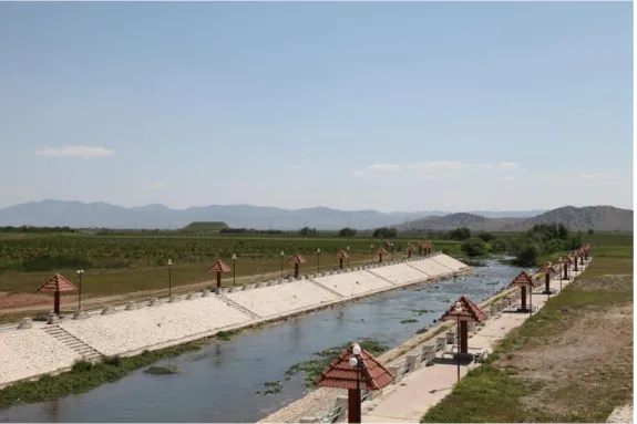
also a diversion conduit of 5mx8m dimension and 2 head regulators with discharge of 2.4m3/s. Concrete-lined Canals have carried out, 4 canals of total lengths 13km. Figure 1 shows the main canal of Ranya Sarchawa project.
Figure 1: Main canal of Ranya Sarchawa irrigation project. 2.4 Shahrizor Irrigation Project
The Plains of Shahrizor are located to the southeast of Sulaymaniyah city and are surrounded by the Mountains of Qardagh, Azmar, Surein, and Reservoir of Darbandikhan Dam. The plains include important cities, most notably Halabja, Sayed Sadiq, Halabja Al-Jadida and others. Although not fully developed, the project is an important site because of its proximity to major cities and the presence of large numbers of people in the region. Polish consultant Polservice prepared a study about the project in 1981 and provided alternatives to the exploitation of the project's land. The first alternative includes the investment of 93,700 dunams as a net area and the second alternative with net area of 56,500 dunams, which was approved by the Ministry of Irrigation later due to the scarcity of water in Diyala River. Irrigation system based on developing springs, from which the water to be conveyed to the nearby lands, the irrigated area is currently estimated at 56,000 dunams.
The spring collections include the following springs groups: a. Bustana Sur group.
b. Meyuan Springs and Chami Mewan group. c. Sarawa group.
d. Khurmal and Balakh group. e. Zalam group.
f. Hassar Qurniah group.
2.5 Kalar Project
The project is located on the left side of Diyala River, where a pumping station on Diyala River of a capacity 2.6m3/s. The station discharge to an 8.7km lined main canal. This canal was lined up and many structure carried out between 2004 and 2008, with net area of 6,000 dunams [1, 2, 3].
3. Eski-Kalak project
Interest in Eski-Kalak project began from the time of the Development Board, where the U.S. Company Koljian was tasked with surveys, detailed study and design and completed its work in 1956. In the early 1970s, coincided with the establishment of a sugar factory in Mosul, the implementation initiated to supply sugar beets. The project draws its water from Great Zab River, Head Regulator with three openings which feeds a 26km main canal and a 9.5m3/s discharge, this canal feeds the first phase of the project, which is around 20,000 dunams, there are branch canals of total lengths 110km. The second stage is irrigated by pumping through a pumping station at the 16km station of the main canal, feeding two canals, first canal no. 5, which is 25km long and feeds an area of 11,000 dunams, and canal no. 10, which is 26km long and irrigates an area of 12.5 thousand dunams. The total length of the branch canals within the second phase is 73km and is currently stopped due to the malfunctioning of the pumping station because the lack of maintenance. All canals are earth canals except 3km at the beginning of the main canal are lined with concrete. The first phase was completed in 1971, and the second phase was completed in 1981 [4, 2, 5].
4. Kirkuk-Adhaim-Hawija Irrigation Project
Although the three projects are widespread within Kirkuk, Salah al-Din and Diyala governorates, the operation of these projects in their current status are carried out by various departments. However, the nature of the project and the hydraulic operation of infrastructures of the project in addition to studies and designs. Thus, can be considered one large project, which is one of the most important projects of the country, where the total area is more than one million dunams. The lands of project are located on the left of Little Zab River, it starts from Dibis district to Kafri district, where the project is supplying from the far downstream discharges to Diyala River, the project is bordered to the south by Zeghaiton Valley, which is one of the tributaries of Adhaim River, in addition to the lands of Left and Right of Adhaim River downstream of Adhaim Dam.
In addition to the project is the feeding and expansion of the old Hawija project, where Hawija project was fed in earlier periods by Fell and Abbasi rivers. The development of the Hawija project was initiated by the development of the Hawija canal in 1936 and opened in 1940, Hawija Canal feeds from Little Zab River, the intake at the site of Batma, a head regulator controls the discharges of a single opening structure, which dimensions is 1.5m×5 m and discharge is 20m3/s. Hawija
canal had suffered and continues to suffer from insufficient water levels during low seasons of Little Zab River. After the construction of Dokan Dam and the thinking of investing the lands to the left of Little Zab, Bennie & Partners commissioned by Development Board began to study the project in 1957, then the French company Sogreah carried out detailed studies of the project, designs and contracting documents during the period between 1966 and 1972. According to the preliminary studies of the project, the total area is 1,448,000 dunams. Figure 2 shows a map of the Kirkuk irrigation project. While the size of the development areas within the project are as follows:
1. 764,000 dunams to be irrigated within the Kirkuk irrigation project.
2. 482,000 dunams to be irrigated on the left and right of Adhaim River, downstream Adhaim Dam.
3. 172,000 dunams of Hawija project.
4. 30,000 dunams is expansion of the Hawija irrigation project.
The project consists of three stages as well Hawija irrigation project, details as following:
4.1 Phase 1
This phase includes parts fed by the main canal of the project to Khardra Valley in Taza district. The main canal in this part is 67km of which 37km is considered feeder canal from the origin head regulator till Multaqa sub-district, of this distance 25km lined with concrete and rubber layers and a part of a length of 12km was lined with rubber layers and coarse gravel, rubber layers were used due to nature of gypsum existing in the area.
Followed that, a distance of 30km lined with good soil and at the end of the canal at this part, there are syphon structure to bypass water under Khasa Valley, this syphon followed by another syphon under Khardra Valley. This phase includes the following:
1. Basin No. 9: The first basin in the project, where at the distance of 8km from the main canal, the basin feed by Qadisiyah pumping station, which is the main station of this basin, has 14 pumping units a total discharge of 28m3/s. The station divert water through pipes of approximately 1.8km length, which flow into a stilling basin of the main canal of Basin 9, this canal covers the lands between Kirkuk city and Dibis city and is surrounded by high lands on both sides. Also on the main canal path, the pumping station (FAO), which comprises 8 pumping units and its total discharge 20m3/s, the canal continues to the nearby of Kirkuk city, where it is located at the end the second pumping station (Shaimaa) which includes 5 pumping units of total discharge 3.25m3/s. This station provides water for Kirkuk municipal needs.
The lands of basin No. 9 are the only ones which are irrigated by pumping as it is high compared to the rest of the project. This basin includes 10,000 dunams irrigated by gravity, and 20,000 dunams irrigated by pumping. 2. Basin No. 1: At the 37km distance from the main canal near Multaqa area,
the main canal of Basin No. 1 branched from the right, the land of Basin No. 1 is located between Little Zab River and Naft Valley, and Bitira hills in the north. At the end of the main canal of this basin, the feeder canal of the Feeder canal Hawija irrigation project branch. The irrigated area in this basin is 104.5,000 dunams and the area irrigated by sprinklers is 30,000 dunams.
3. Basin No. 2: In the area between Naft Valley and Abu Shihma Valley is the land of Basin No. 2, which has an area of irrigated land of 84.5 thousand dunams. The main canal of the project is a joint canal which feeds Basin No. 2 as well as the eastern parts of Hawija irrigation project.
4. Basin No. 3: It is the land between Abu Shihma Valley and Khardra Valley. Basin area is 41,000 dunams irrigated by gravity, and 10,000 dunams irrigated by sprinklers.
4.2 Phase 2
Land of this phase extends from Khardra Valley to Narin Valley in Kafry district, the main canal in this part is 63.3km long and passes through several siphons, including Tawook Chai at Tawook Chai Valley at the distance of 87km from the main station, which was planned to establish a hydropower station on it, as well as the siphon of Tuz which built in 200, the length of it is 1320m, it includes two openings with dimensions 3mx3.75m and a total discharge of 51m3/s. Within this phase are the following basins:
1. Basin No. 4: The land between Khardra Valley and Tawook Chai Valley, the area of 65,000 dunams irrigated by gravity.
2. Basin No. 5: The land between Tawook Chai Valley and Tuz Chai Valley, the area of 99,000 dunams, is partially irrigated and partially implemented. 3. Basin No. 8: The land between Tuz Chai Valley and Narin Valley, the area
of 150,000 dunams partially implemented, from this stage the extension of main canal continues to supply Narin Valley with water, which flows into Diyala River to support discharges.
The distribution canals in Kirkuk irrigation project are designed from the type of closed pipes, which are mostly asbestos pipes and the outlets of these pipes are in the form Hydrants, this configuration is called the California System, while the water course canals are pre-cast suspended flumes sitting of pre-casted stands. These infrastructures were largely implemented in the first phase. The second phase, many of which were implemented after the economic blockade, has been shifted towards open canals adaption. The two-stage pipeline lengths are 600km, while the flumes have a total length of 2,250km.
4.3 Phase 3
The land located at the downstream of Adhaim Dam, on both sides of Adhaim River, it consists of the following parts:
1. Adhaim Weir: It is located 4km downstream from Adhaim Dam to ensure the operational levels of basins 6 and 7 of the third phase, the site of the weir has been selected by the consultant Benniee & Partners, and was designed by Faw Office of Engineering Consultancy and implemented by the General Company for Industrial Crops of the Ministry of Agriculture in 2001. The weir is 137.2m long and 5.5m high at an average of 89.5m a.s.l. Normal discharge is 1,150m3/s and a maximum discharge is 3,500m3/s. There is also a saddle dam functioning as emergency spillway. The weir has 2 gates for sediment removal, with a total discharge of 50m3/s.
2. Basin No. 6: It lies to the right of Adhaim River, downstream of Adhaim Dam, where these lands are fed through the head regulator which is right of the Adhaim Weir, the regulator discharge the water to a 44.1km canal which feeds the project, its discharge is 43.3m3/s, form the canal length about
12.6km is not lined. The net area to be irrigated within this basin is 129,000 dunams and is currently partially implemented. The development and management of these lands has been entrusted to the General Industrial Crops Company, which is slowing down. The land of Basin No. 6 drainage is discharging toward Shari Lake.
3. Basin No. 7: which is on the opposite side of Basin No. 6. Its land is among the future projects, with an area of 101,000 dunams.
4.4 Hawija Irrigation Project
As mentioned earlier, Hawija irrigation project is one of the old existing projects. The project area in full development will be 137,000 dunams. From the beginning, the project feeds from Little Zab River through head regulator near the Batma site, and the water passes to a 28.6km main canal, from which, there are several branches branch:
1. Northern branch: Branching at the 4.2km distance of the main canal to feed the basins [1, 2, 4]. It is preceded by basins 3 and 10, which draw water directly from the main canal.
2. Western Branch: Branching at the end of the main canal and feeding the basins [5, 6, 7, 8, 9, 11].
3. Southern Branch: Branching at the end of the main canal and feeding the basins.
4. Eastern Branch: The largest branch where it branches at the end of the main canal and feeds the basins.
The drainage system of the project is the natural drainage to the ancient rivers, namely Abbasi and Fell Rivers, and as there is no control on water levels downstream the head regulator. The project's feeding and expansion have been studied and expanded as part of the Kirkuk irrigation project. After examining several alternatives, the option of feeding the project was reached through two routes, the first from the end of Canal A1 in Basin 1, which feeds the main canal with its branches except parts of the eastern branch. The second feeding route is the mentioned Joint Canal, which feeds parts of the eastern branch after the 17km distance, to irrigate the basins.
The project was developed in the 1940s, reclamation works were initiated again and the first stages of modern development opened in 2001 and continued until 2003. Due to security status and many other factors, the development of the southern parts of the project stalled after 2003. As a result of the water scarcity and the rotation of canals operation, the canal which are fed from basins 1 and 2 of the Kirkuk irrigation project have been included, this reflecting negatively on the status of Hawija project and highlighting the problem of water scarcity once again.
At the end of the review of Kirkuk irrigation project, this giant project, which was hoped to cover an important part of the country's need for food and the operation of labor, provides a model of the reasons which led to the delay in the completion of such important projects [2, 7, 8, 9, 10, 5, 11, 12].
5. Middle-Diyala projects
For the land which feeds from Diyala River downstream of Darbandikhan Dam to Hemrin Dam, it is divided into the lands of Upper Diyala and Middle Diyala. Most of what is exploited from these projects is within a geographically middle-lying area, which is mainly exploited and does not involve full reclamation. They are as follows:
5.1 Balajo- Khanaqin Project
An old existing project that feed from Wand River, and as the Iranian side cut off water from the river, in 1960 the General Irrigation Directorate implemented the project to supply Balajo Canal, which feeds from Diyala River to revive Wand River. The project covers an area of 80,000 dunams, which is irrigated from Balajo Canal and Wand River, and lands of Dakat project, which is irrigated directly from Diyala River. The head regulator of the project is on the left of Diyala River, discharging to the 39.5km long main canal which is the same Balajo Canal; the discharge is 10m3/s. The canal was lined with concrete, for the land which feeds from Wand
River itself, on the right side, land is irrigated through Haj Qara and Qulai canals, while the left side irrigates land through Alyawah and Khanaqin canals.
5.2 Sheikh Langar Project
The land of the project is located in the plains between Kafri district and Diyala River. The total project area is 34,280 dunams divided into two phases, the first within area of 18,350 dunams of water and is currently exploited where a main lined canal of 25km and branch canals with total length of 38km to cover this stage, the second stage is a future stage, planned to be irrigated by pumping and sprinklers, the area of this stage is 15,750 dunams.
5.3 Qara Tabeh Project
An exploited irrigation project located on the right of Diyala River, the project's land is bordered by Diyala River and The Hemrin Dam Lake. The project area as planned after the development is 104,000 dunams, while the current irrigated area is 71,000 dunams. All canals of the project are earth canals, within the command area of the project, there are the following canals:
a. Salam Canal of discharge 2m3/s.
b. Qara Tabeh Canal of discharge 5.27m3/s. c. Kashkul Canal of discharge 2.55m3/s. d. Qara Bulagh canal with discharge of 1m3/s.
e. Mihnat Abad Canal with 1m3/s discharge.
5.4 Saadiya Project
The land in Saadiya area is on the left of Diyala River and feeds from Saadiya earth canal, which is branching from Diyala River in Jalwlaa district; the length of the canal reaches 22km and its discharge 2m3/s. The project is part of the future development plans to increase irrigation area through pumping [6, 8, 7, 4, 1, 13].
6. Khalis Irrigation Project
Khalis project is one of the strategic and important projects where the land is covered the right agricultural area of the lower reach of Diyala River, it is fed from the upstream of Diyala Barrage, where Khalis head regulator are. Some of the lands under project command area are irrigated from Tigris River by pumping. Khalis project is divided into two projects, Upper Khalis and Lower Khalis. As a part of its study of Diyala River utilization, Sir M. MacDonald studied the project and reported from 1957 to 1960, the first implementation was initiated in 1967 and continued until 1985.The main Khalis canal is 105 km long, the upstream part of it is 53km unlined, and the rest is lined with concrete. The highest discharge of the canal is 96m3/s, and its normal discharge is 65m3/s. In addition to the main canal, Khalis irrigation project includes the following:
1. Secondary canals of 169km, 91km earth canals, 78km lined.
2. Branch canals with length of 538km, 224km earth canals, 314 kilometers lined.
3. Distributary canals of length 1198km, 1188km earth canals, 810 kilometers lined.
The project also covered by a drainage network, where the water of the drainage is pumped or drained into Diyala River or Tigris River. The drainage network consisting the below details:
1. 258km main drains. 2. 552km secondary drains. 3. 2286km collector drains. 4. 6668km field drains.
Khalis is a pioneering project, including the use of sprinkler and drip irrigation techniques, as well as the use of self-propelled gates of Avis and Avio. Irrigation Automation system was also adopted in the lower Khalis project, where the control center in Ghalbiya area in Diyala governorate is controlling the opening and closing of the gates, due to man error in 1991 the system was damaged and stopped. The net area of the Upper Khalis project is 215,837 dunams, of which 13,960 dunams of orchards are. The net area of Lowe Khalis is 230,000 dunams, of which 10,000 dunams of orchards. Khalis project includes a number of major pumping stations:
1. Khalis pumping station: the largest pumping station in the project has been implemented in a record time from 25/3/2000 to 1/6/2000 to cope with the
scarcity of water in Lower Khalis, where the station has 42 metric pumping units, as well as 16km lined canal to convey water to Lower Khalis, the maximum discharge is 50m3/s.
2. Jizani pumping station: supporting station to irrigate some land and provide Khalis canal with water drawn from Tigris River, the station includes 12 half-metric pumping units, 4 metric pumping units, the capacity is 6m3/s. 3. Rashidiya Pumping Station: the station lifts water from Tigris River to
irrigate land near the river; discharge is 2.5m3/s. It has 6 different pumping
units with different capacities.
4. South Rashidiya Station: the station lifts water from Tigris River to irrigate land near the river; discharge is 2m3/s. It has 11 different pumping units with
different capacities.
5. Dawoodi Drainage Station: This station drains the water of the Dawoodi Drain into Tigris River; it contains 6 metric pumping units.
6. Drainage DD2 station: This station discharges DD2 drain into Tigris River and includes two half-metric pumping units.
7. KSD Drainage station: This statin is on KSD drain and contains 6 metric pumping units.
8. KSD 6 Drainage station: This statin is on KSD 6 drain and includes a metric pumping unit [2, 7, 8, 9].
7. Combined Reach projects
These are some projects have long been fed by from the left of Diyala River from a number of ancient streams, including orchards, which included the area studied by the consultant Sir M. MacDonald, as in Khalis project within the projects of lower Diyala. After the completion of Diyala Barrage, these projects were organized to feed the water from the Combined Reach head regulator and the Combined Reach Canal, the projects in this section includes the following parts:
7.1 Combined Reach Canal
After the Combined Reach head regulator at Diyala Barrage, the water is discharge to the 14.6km long Combined Reach canal, which has a capacity of 129m3/s. It feeds
the projects of Mandali, Ruze, Muqdadiyah, Mahrut and Saryah. Along this canal there are several regulators, the most important of which is the 3.5km regulator, which is a cross regulator with 6 openings of dimensions 2.5m×4m and a maximum discharge of 117.8m3/s. There are also some of head regulators feed from Combined Reach canal, the most important of which are:
a. Mandaly head regulator: It is at the 3.5km distance, on the left of Combined Reach canal, it has two openings with dimensions 1.75mx3.5m and discharge of 6.9m3/s.
b. Ruze head regulator: It is at the 3.5km distance, on the left of Combined Reach canal, it has 4 openings with dimensions 2mx4m and discharge of 47.5m3/s.
c. Mahrut head regulator: It is at the end of Combined Reach canal, it has 5 openings with dimensions 4mx2.3m and discharge of 75m3/s.
d. Saryah head regulator: It is at the end of Combined Reach canal to the right of Mahrut head regulator, it has 4 openings with dimensions 4mx2.3m and discharge of 32m3/s.
The infrastructures that were mentioned above had been implemented in 1969.
7.2 Mandaly Irrigation Project
As it is known, Mandaly area is a border territory known with its orchards and its inhabitants depend on agriculture. Orchards watering are supplied mainly from the Harran Valley, which originates from the Iranian side and feeds as soon as it comes out of the Strait of Komastic, the streams of Falshat, Al-Suwaiq, Jizani, and Mawalih. The Iranian side used water unfairly and river discharges decreased during the 1930s, resulting in a shrinking area of orchards, population migration and a decrease in the number of residents in Mandaly. General Irrigation Directorate studied the issue in the 1930s and 1940s and the choice was to dig wells and pump water into the streams, but this did not work, as the wells were depleted after a period of operation and after studying the area by consultant Sir M. McDonald, several alternatives were analyzed to enhance the area with discharges from Diyala River. The current alternative, an open canal fed from the Combined Reach canal and through a number of pumping stations and pipeline tracks, was chosen to deliver water to Mandaly.
Mandaly Canal started at the 3.5km distance of the Combined Reach canal and continues as an open canal, at the 25km distance is pumping station 1, where this station has 6 pumping units and its maximum discharge is 7.2m3/s. The canal passes through a 150cm diameter pipe for 2.28km, which will then be completed as an open canal again. At the 44km distance, pumping station 3, which has six pumping units with discharge capacity of 2.7m3/s, feeds agricultural land in Naft Valley. At the distance of kilometer 54 the canal branching into a series of canals feeding the agricultural land as well as there is pumping station no. 2, which includes 6 pumping units with different capacities and discharge of the station amounting to 1.25m3/s.
This station provides drinking water for the city of Mandaly and watering orchards there.
Mandaly Canal was implemented in the 1970s and subsequently collapsed due to the presence of gypsum layers in the soil, hence, the replacing the lining of concrete with rubber layers in some sections of the canals was considered. The expansion of agricultural areas was planned to achieve the economic feasibility of the project, but the existence of gypsum layers was prevented, and the role of the project became to meet the needs of drinking for humanitarian and social purposes. With a planned net irrigation area of 29,000 dunams, the irrigated area became is 5,044 dunams of orchards and 1,316 dunams of land grown with crops.
with sediments.
7.3 Ruz Project
The project is located between Mahrut project and Salah Al-Dein path, which protects the east of the project from floods and drains project's land to Attariya depression, which will be developed in the future to Aziziyah evaporator. Ruz Project feeds through the main Ruz canal, which has a discharge of 38.8m3/s. The canals that feed from the main canals up to the 21km distance are located within the boundaries of Muqdadiyah project and this distance is not lined. Then the boundaries of Ruz project begin. Reclamation has been under way since 1979 and has achieved a net area of 170,000 dunams. The project's net irrigated area is 230,000 dunams. The canal also supplies drinking water to the city of Baladruz. The reclamation work included the following details within the irrigation and drainage networks:
a. Main and secondary canals, 31.5km long lined and 21.5km unlined. b. Branch canals, 309.5km long lined and 8km unlined.
c. Distributary canals, 1038.4km long lined and 272km unlined. d. Irrigation structures, 809 structure.
e. Main Drains, 197km . f. Secondary Drains, 340km g. Branch Drains,1,100km. h. Field Drains, 4,410km.
7.4 Muqdadiyah Irrigation Project
Muqdadiyah Irrigation Project is located between Diyala River and the borders of Ruz, Mahrut and Saryah projects, it is mainly fed by the canals branching from the Combined Reach Canal and the Main Rose Canal within the areas of Muqdadiyah district. The project is one of the oldest projects that have been redeveloped and some canals have been lined between 1982 and 1985. The net area of approximately 73,000 dunams, including 20,964 orchards and 49,872 reclaimed dunams. The most important canals of the project are:
a. North Haroniyah Canal: At the 0.5km distance, it is branched from the right side of Combined Reach canal, the discharge of the canal is 1.22m3/s. b. South Haroniyah Canal: At the 3.5km distance, it is branched from the left
side of Combined Reach canal, the discharge of the canal is 1.7m3/s. c. Muqdadiyah Canal: At the 3.5km distance, it is branched from the left side
of Combined Reach canal, the discharge of the canal is 6m3/s.
d. Group of canals branched from Ruz Canal up to the distance of 21km , have total discharge of 4.7m3/s.
e. Group of canals branched from Combined Reach Canal, have total discharge of 9m3/s.
details, including the above-mentioned canals:
a. Main canals, 15.61km long lined and 87.4km unlined. b. Branch canals, 96.7km long.
c. Secondary canals, 15.2km long lined and 218.6km unlined. d. Main Drains, 96.92km.
e. Branch Drains, 59.6km. f. Field Drains, 289.8km.
7.5 Mahrut Irrigation Project
The land of the Mahrut project covers a large area and is partly implemented. The project is located between Ruz and Saryah projects. The project feeds from the Mahrut Canal, which begins at the end of Combined Reach Canal and extends Kanaan Canal, and like the rest of the surrouding projects, the land is drains to Attaryah depression. The main canal of the project was implemented in 1981 and development work was resumed in 2001 and stopped in 2003. The net area of the project is 167,000 dunams. Mahrut Canal is 77.9km long, of which 26.14km at the beginning is lined. In addition to Kanaan Canal, Al-Izia, Doiylia and Sibana Canals, with total length of 140km, are branched from the left. The project also includes main drains, which are:
a. Mahrut Main Drain: This drains projects of Muqdadiyah, the north-western part of Ruz project and the eastern parts of the Mahrut project.
b. Northern Sariyah Drain: This drains parts of the Sariyah project and the northwestern parts of Mahrut project.
c. Southern Sariyah Drain: This drains the northern and southern parts Sariyah project and part of Mahrut project.
7.6 Sariyah Irrigation Project
The last project in the series of projects on the left of Diyala Lower, its land is confined between Diyala River and Mahrut project. The project does not include reclamation work, but the work included linking the old canal to Combined Reach canal. The project is one of the most densely populated Diyala River projects and its territory is under continuous urban expansion as many cities are located within the command area of the project, the most important of which is Baquba city. The net area of the project is 162,000 dunams with 37,000 dunams of land in Tel Asmar, which is located in the project's tail area. There are also 35,000 dunams of orchards. Parts Sariyah canal have been lined when they pass through Baquba and Buhrez. For the land of Tel Asmar, which includes the canals (Shakha 1 and Shakha 2), this area suffers from scarcity of water in the summer season. Though, Buhrez pumping station built to support discharge from Diyala River, the station includes 8 metric pumping units [6, 7, 8, 9, 10].
8. Conclusion
Several aspects are distinguishable in the projects that had been built along the tributaries of Tigris River, which are:
1. The main scheme of the projects is the existence of Reservoir, Barrage, and main canals starting from the upstream of the barrage to irrigate lands. This does not implement yet for Great Zab River.
2. Seizing of the Iranian side to more water quantities day by day is threatening the status of irrigation in Diyala and Eastern Valleys.
3. There are many opportunities to improve the food security and socio-economic conditions through more development for the small projects in the northern regions.
References
[1] Sousa, A. and Sevian, V. (1965). A Report about Potential Irrigation Projects in Northern Areas: Part 1 (in Arabic).
[2] AL-Simawi, H. (2010). Irrigation and Drainage Projects in Iraq. [3] AL-Simawi, H. (2008). Encyclopedia of Dams in Iraq.
[4] Board, S.A. (1977). Large and Medium Agricultural Projects (in Arabic). [5] Sousa, A. (1966). Baghdad Floods in the History: Volume 3 (in Arabic). [6] Resources, M. of W. (2005). The Encyclopedia of Irrigation in Iraq, February
1918-February 2005.
[7] AL-Simawi, H. (2011). Irrigation and Drainage Pumping Stations in Iraq (in Arabic).
[8] AL-Simawi, H. (2014). Irrigation Regulators in Iraq until the end of the year 2013.
[9] Ministry of Irrigation (2001). The Implemented Projects from 1/1/1996 to 1/6/2001.
[10] Directorate General of Irrigation (1954). Report about Directorate General of Irrigation Works for a Five Years from 1949 to 1954 (in Arabic).
[11] Mosul, U. of Hawija Project (1978). From Services to Production (in Arabic). [12] Partners, B (1962). Kirkuk Irrigation Project: Feasibility Report.
[13] Hassun, S.A and Al-Haialy, A.A.A. (2015). Regional Planning and Rural Development in Khanaqin District Farmland (in Arabic).
![Figure 2: Map of Kirkuk irrigation project. (Source: [6]).](https://thumb-eu.123doks.com/thumbv2/5dokorg/4268851.94641/7.813.164.646.124.875/figure-map-kirkuk-irrigation-project-source.webp)
