Shortgrass Steppe Symposium
January 14, 2005
r
r
r
r
r
r
r
r
r
r
r
r
r
r
r
r
r
r
r
2005
Shortgrass Steppe Symposium
:Mang people ana organizations liave lie{pea make tliis sgmposium possi6{e. We e~tena our tlianks to a{{ of tliem for tlieir contri6utions.
Special tlianks are aue to tliose 6e{ow.
USDA Forest Service, Pawnee National Grassland for the National Grassland pins
Rocky Mountain Bird Observatory for the Pocket Guide to Prairie Birds
Judy and Wade Hendryx for the artwork for the SGS LTER logo used on the Symposium mugs
Dana Blumenthal, Indy Burke, Bob Flynn, Mark Lindquist, Jack Morgan and Maureen O'Mara for musical entertainment
Bob Flynn, Judy Hendryx, Nicole Kaplan, Mark Lindquist, Jeri Morgan, Sallie Sprague, and Caroline Yonker for their dedication and
hard work putting together this Symposium
rrlie cover for tlie 2005 Sliortgrass Steppe Symposium sliows tlie winning pliotos from tlie contest lie{a auring tlie 2003 Symposium. Tliankgou to a{{ tlie pliotograpliers for giving us permission to use
tlieir pliotos for
sqs
LTE'R....projects ana activities.Photo Credits Background:
Paul Stapp "Summer Sunset on the Pawnee with Windmill" Insets, left to right:
Nicole Kaplan "Don't Touch, It's Hot"
Dave Smith "Pronghorn Fawns Minutes after Delivery" Mark Lindquist "Holy Hail Fell from the Sky in Spring" Amy Yackel Adams "Hognose Snake Eating Short Horned Lizard"
1. Presenting Author: 2. Affiliation:
N. Kathryn Morgan Colorado State University
Poster Number: #23 Location: 224 - 226 (am)
3. Address: Dept. of Natural Resource Recreation and Tourism Colorado State University
Fort Collins, CO 80523-1480 4. Phone number: 970-491-0205
5. E-mail: nkmorgan @latnar.colostate.edu
Morgan, N.K., P. Newman, and G.N. Wallace. (Natural Resource Recreation and Tourism). Recreational Shooting on the Pawnee National Grassland: A Qualitative Case Study
Population growth along Colorado's Front-Range has resulted in increasing use levels on the Pawnee National G~assland (PNG) in general and recreational target shooting in particular. Front Range urbanization has also led to the closure of a number o~ the areas previously used by
recreational shooters. PNG managers have seen an increase in the intensity and spatial
distribution of recreational shooting as well as a number of associated impacts. For managers to respond effectively to the challenges associated with increased use, and make appropriate
management decisions, it is imperative that they understand the breadth and depth of stakeholder views of recreational shooting across all stakeholder groups. This case study explores the social setting on the PNG by describing the stakeholder groups, relationships between groups, and the views of individual users. Semi-structured interviews with 24 informants across multiple
stakeholder groups were conducted. The transcribed interviews were coded, identifying common themes across all interviews. These identified themes, such as safety, ecological integrity, vandalism, and place attachment, highlight issues and views that allow managers to see beyond the labels of protected area stakeholders, and better understand their diversity of users. Shooters have many reasons for using the PNG, including the absence of use fees or time restrictions. Many feel that with private ranges in the area increasing their fees and capping memberships, they have no where else to go. Most other users do not have a problem shooting in particular, but rather some of the impacts associated with this increased use, such as property damage, unsafe shooting practices, trampled vegetation, and litter. This case study tells the story of recreational shooting on the Pawnee National Grassland today in the interest of giving managers better information from which to make decisions.
Results Table 1
Stakeholder Ranchers Researchers Birders Horseback Recreational Managers
Group Riders Shooters
Identified • Have no • Find doing • See shooting
.
Dislike·
Very broad • As shootingThemes problem with rcsc.1rch as highly seeing trash spectrum of numbers
shooting, but within sound disruptive to from shooter people increase, with of shooting their use
·
Reasons for spend more irresponsible unnerving recreation • Safety and using PNG: of their time behavior • Have had and disturbance have few managing • Major close calls enjoyment of issues for other options shootingcomplaint is when the place humans and for shooting • See vandalism! shooters • Concerned horses make in northern increasing damage to have not seen about effects them wary of Colorado, impacts to stocktanks, them in the to the land riding at enjoy the other users, windmills, field and wildlife PNG. and open space, wildlife, and fences ~ Concerned populations avoid areas no use fees, the land as • Concern for about the from where long ranges shooting
personal effects of shooting. shooling is
·
Also dislike increases safely when shooling on occurring if visualworking the they can impacts:
cattle near organisms trash
Chrissy Alba Tom Baur John Bradford Reesa Conrey Mauricio Cotera Jim Curtis Butch DePorter Kat Morgan Peter Newman Kim Obele Bruce Rittenhouse Dan Salkeld Jason Stevens Jimmie Sylvest Aryn Wilder
Additional
2005 Shortgrass Steppe Symposium
Participants
SGS-LTERlCSU, Department of Biology Crow Valley Grazing Association,
Board Vice-President
U.S.F.S. Rocky Mountin Research Station CSU, Department of Biology
Universidad De Nuevo Leon
Crow Valley Grazing Association, Board Secretary Crow Valley Grazing Association,
Board of Directors
CSU, Department of Natural Resources and Recreational Tourism
CSU, Department of Natural Resources and Recreational Tourism
CS U, Department of Forest, Rangeland and Watershed Stewardship
National Park Service
California State - Fullerton, Department of Biological Sciences
SGS-LTER
USDA-Forest Service, Pawnee National Grassland CSU, Department of Biology
2005 Shortgrass Steppe Symposium
Lory Student Center (LSC)
@Colorado State
University
January
14,
2005
Key Issues for Management, Research, and Conservation
8:15 - 8:45 LSC 227 8:45 - 9:00 LSC 228 9:00 - 9:30 LSC 228 9:30 - 9:50 LSC 228
Registration, poster set-up and coffee
Overview: Management needs and challenges for the Shortgrass Steppe Gene Kelly, Colorado State University
Issues of grazing
Justin Demer, Agl-icultlll-al Research Service Discussion
9:50 - 10:05 Break (refreshments) LSC 224-226
10:05 - 10:35 Issues of drought
LSC 228 Nolan Doeskin, Colorado State University 10:35 - 10:55 Discussion
LSC 228
11 :00 - 12:00 Postel-session LSC 224-226
12:00 - 1 :00 Lunch with entertainment Che.-okee Park 1:00-1:30 LSC 228 1:30 -1 :50 LSC 228 ] :50 - 2:20 LSC 228 2:20 - 2:40 LSC 228 2:40 - 3:00 LSC 228 3:00 - 4:00 LSC 220-222
Issues of weeds and invasive species
Dana Blumenthal, Agricultural Research Service Discussion
. Issues of p.-airie dogs and faunal diversity Mike Antolin, Colorado State University Discussion
Synthesis: What would we like to know and where,do we go to meet new
challenges in Inanagcment, l·esearch, and conservation?
Alan Knapp, Colorado State University Poster session (rer.-eshments)
r
r
r
Amy Yackel Adamsr
Joe Alfierir
Ty Allen Amariah Andersonr
Mike Antolinr
Mary Ashby Marilyn Bantar
Adriana Beltranr
Heather Blackburn Peter Blankenr
Steve Bleckerr
Dana Blumenthalr
Megan Bowes Anne Brewsterr
Indy Burker
Phil Cafaror
Cathy Cannon Brent Cassr
Rich Conantr
Tom Creeganr
Steve Currey Kathy Damasr
2005 Shortgrass Steppe Symposium
Participants
CSU, Department of Fishery and Wildlife Biology CU - Boulder, Department of Geography
GroverFFA
SGS-LTERlCSU, Department of Biology SGS-LTERlCSU, Department of Biology USDA-ARS Central Plains Experimental Range SGS-LTERIUNC, Dept. of Biological Sciences SGS-LTER/CSU, Dept. of Atmospheric Science SGS-LTERlCSU, Department of Biology
CU - Boulder, Department of Geography
SGS-LTERlCSU, Dept. of Soil and Crops Sciences SGS-LTER, USDA-ARS, Rangeland Resources Research Unit
City of Boulder Open Space and Mountain Parks Office of Senator Wayne Allard
SGS-LTERlCSU, Dept. of Forest, Rangeland, and Watershed Stewardship
CS U, Department of Philosophy
SGS-LTERlCSU, Dept. of Soil and Crops Sciences Grover FFA
CSU, Natural Resource Ecology Laboratory Rocky Mountain High School
USDA-Forest Service, Pawnee National Grassland City of Boulder Open Space and Mountain Parks
r
r
r
Safi Dardenr
Justin Dernerr
Jim Detlingr
Allen Diehlr
Nolan DoeskenL
Jeff Dotyr
Tamara Driskillr
James Dyer
Greg Eckert Steven Fassnachtr
Bob Flynnr
Seth Gallagherr
Mark Gershman L Doug Grantr
Bonnie Grayr
Niall Hanan Dave Hannir
Neil Hansen ~t'
Kelly Hardwicker
Erik Hardy Laurel Hartleyr
2005
Short grass
Steppe Symposium
Participants
University of Copenhagen, Department. of Population Biology
SGS-LTER, USDA-ARS, High Plains Grasslands Research Station
SGS-LTERlCSU, Department of Biology Shortgrass Steppe Rancher
CSU, Department of Atmospheric Science CSU, Arthropod-Borne and Infectious Diseases Laboratory (AIDL)
Rocky Mountain High School
SGS-LTERlUNC, Dept. of Biological Sciences National Park Service
CS U, Department of Forest, Rangeland and Watershed Stewardship
SGS-LTERlCSU, Dept. of Soil and Crops Sciences Rocky Mountain Bird Observatory
City of Boulder Open Space and Mountain Parks USDA-ARS, Rangeland Resources Research Unit SGS-LTER/CSU, Dept. of Soil and Crops Sciences CSU, Natural Resource Ecology Laboratory
Rocky Mountain Bird Observatory
CSU, Department of Soil and Crop Sciences SGS-LTER/CSU, Department of Biology
USDA-ARS, Rangeland Resources Research Unit SGS-LTERlCSU, Department of Biology
r
r
r
r
r
r
r
r
r
r
r
r
r
r
r
r
r
r
J ana Heisler Judy Hendryx2005 Shortgrass Steppe Symposium
Participants
SGS-LTERlCSU, Department of Biology
SGS-LTERlCSU, Dept. of Soil and Crops Sciences Terri Hicks-Anderson Rocky Mountain Bird Observatory
Beth Humphrey Jiong Jia Marc Johnson Sue Kamal Scott Kanode Tammy Kanode Nicole Kaplan Gene Kelly Steve Kittrell Ryan Klinginsmith Alan Knapp Fritz Knopf Bill Lauenroth Dan LeCain Mark Lindquist Carol Lynch Kent Lynch Terra Mascarenas
USDA-Forest Service, Pawnee National Grassland CSU, Department of Forest, Rangeland, and Watershed Stewardship
CS U, Dean, College of Agricultural Sciences and Vice Provost for Agriculture and Outreach UNC, MAST Institute
Crow Valley, Central Plains Experimental Range Crow Valley, Central Plains Experimental Range SGS-LTERlCSU, Dept. of Soil and Crops Sciences SGS-LTERlCSU, Dept. of Soil and Crops Sciences USDA-Forest Service, Pawnee National Grassland Grover FFA
SGS-LTERlCSU, Department of Biology U.S. Geological Survey
SGS-LTERlCSU, Dept. of Forest, Rangeland, and Watershed Stewardship
USDA-ARS Rangeland Research Resource Unit SGS-LTERlCSU, Dept. of Soil and Crops Sciences Shortgrass Steppe Rancher
S hortgrass Steppe Rancher
USDA-Forest Service, Arapaho Roosevelt National Forest/Pawnee National Grassland
r
r
r
r
r
r
r
r
r
r
r
r
r
r
r
r
r
r
r
Kim Melville-Smith S uellen Melzer Daniel Milchunas John Moore Jack Morgan Jeri Morgan Ken Morgan Matt Mortenson Seth Munson DeAna N asseth Moffatt Ngugi John Norman Jessica Nusbaum Tanna Nussbaum Megan O'Connell Maureen 0 'Mara Gary Peterson Tom Peterson Jacque Pevler Alain Plante2005
Short grass
Steppe Symposium
Participants
SGS-LTER, UNC, MAST Institute
SGS-LTERlCSU, Dept. of Soil and Crops Sciences SGS-LTERlCSU, Dept. of Forest, Rangeland, and Watershed Stewardship
SGS-LTERlUNC, Dept. of Biological Sciences SGS-LTER, USDA-ARS, Rangeland Resrouces Research Unit
SGS-LTERlCSU, Dept. of Soil and Crops Science Colorado Division of Wildlife
USDA-ARS, High Plains Grasslands Research Station
SGS-LTERlCSU, Dept. of Forest, Rangeland, and Watershed Stewardship
CSU, Department of Forest, Rangeland, and Watershed Stewardship
CSU, Natural Resource Ecology Laboratory CSU, Natural Resource Ecology Laboratory Grover FFA
Grover FFA
SGS-LTER/CSU, Dept. of Forest, Rangeland, and Watershed Stewardship
CSU, Department Head, Soil and Crop Sciences CSU, Natural Resource Ecology Laboratory Grover FFA
r
r
r
Frances Pusaterir
Meghan Quirkr
Jean Reeder Jim Reederr
Randy Reichertr
Lori Reinsvold Lynn Riedelr
Todd Ringler ~ Bruce Rittenhousel
Janelle Rohder
Renee Rondeaur
William Rosenbergr
Beth Ross Ron Ryderr
Buck Sanfordr
Rick Scherer Jerry Schumanr
Jennifer Sherryr
Kate Shoemakerr
Jack Sifersr
Susan Skagen Rod Simpsonr
2005 Shortgrass Steppe Symposium
Participants
Colorado Division of Wildlife
SGS-LTERIUNC, Dept. of Biological Sciences USDA-ARS Rangeland Resources Research Unit City of Boulder Open Space and Mountain Parks USDA-Forest Service, Pawnee National Grassland SGS-LTERIUNC, MAST Institute
City of Boulder Open Space and Mountain Parks CSU, Department of Atmospheric Sciences National Park Service
GroverFFA
Colorado Natural Heritage Program
SGS-LTERIRough Rock Community School-Arizona ,Chair, Department of Science
CSU, Department of Biology
SGS-LTER/CSU, Fishery and Wildlife Biology University of Denve, Dept.. of Biological Sciences CSU, Department of Fishery and Wildlife Biology USDA-ARS, High Plains Grasslands Research Station
City of Boulder Open Space and Mountain Parks Grover FFA
Grover FF A Advisor
SGS-LTERIUNC, Dept. of Biological Sciences u.S. Geological Survey
r
r
r
r
r
r
r
r
r
r
r
r
r
r
r
r
r
r
r
2005
Short grass
Steppe Symposium
Participants
David Smith Lee Sommers Sallie Sprague Jeff Sprock Paul Stapp Lise Steffensen Patty Stevens Jeff Thomas Scott Timm Theodore Toombs Dan Tripp Tammy VerCauteren Joe von Fischer John Wagner Jeff Wahlert Rob Wang Molly Ward Jason Werner Dwayne Westfall Jennifer W o1chansky Caroline YonkerUSDA-ARS Rangeland Resources Research Unit CSU, Director, Agricultural Experiment Station SGS-LTER/CSU, Dept. of Soil and Crops Sciences Rocky Mountain Bird Observatory
SGS-LTER/Cal. State - Fullerton, Dept. of Biological Science
University of Copenhagen, Department of Population Biology
U.S. Geological Survey
USDA-ARS Central Plains Experimental Range Shortgrass Steppe Rancher
Environmental Defense
SGS-LTER/CSU, Department of Biology Rocky Mountain Bird Observatory CSU, Department of Biology Colorado Division of Wildlife Shortgrass Steppe Rancher
SGS-LTER, Antioch University, Seattle WA USDA-Forest Service, Arapaho Roosevelt National Forest/Pawnee National Grassland
Grover FFA
CSU, Department of Soil and Crop Sciences CU-Boulder, Department of Geography
r
2005 Shortgrass Steppe Symposium
Acronym Definitions
r
AES Agricultural Experiment Station
r
AIDL Athropod-Borne and Infectious Disease Laboratoryr
ARS Agricultural Research ServiceCDOW Colorado Division of Wildlife
r
CNHP Colorado Natural Heritage Programr
CPER Central Plains Experimental RangeCSU Colorado State University
r
CU University of Colorador
DU University of DenverFS Forest Service
r
GDPE Graduate Degree Program in Ecologyr
GIS Geographic Information Systemsr
GPS Global Positioning SystemMAST Math and Science Teaching
r
NRCS Natural Resources Conservation Servicer
NREL Natural Resource Ecology LaboratoryNSF National Science Foundation
r
PNG Pawnee National Grasslandr
RMBO Rocky Mountain Bird ObservatoryRRRU Rangeland Resources Research Unit
r
SGS-LTER Shortgrass Steppe Long Term Ecological Researchr
TNC The Nature ConservancyUniversity of Northern Colorado UNC
r
USDA United States Department of Agriculturer
r
r
r
r
r
r
r
r
r
r
r
r
r
r
r
r
r
r
2005 Shortgrass Steppe Symposium
Poster Presentations
First Author (1) Alfieri, Joseph (2) Beltrcln-Przekurat, Adriana (3) Blecker, Steve (4) Darden, Safi-Kirstine (5) Dye, James (6) Flynn, Robert (7) Grant, Doug (8) Hanan, Niall (9) Hardwicke, Kelly (10) Heisler, lana Title LocationA Comparison of the Bowen Ratio Energy 220-222 (am) Balance and Eddy Covariance Methods for
Determining Surface Fluxes over Shortgrass Steppe
Land-Atmosphere Interactions in Semiarid 220-222 (am) Areas: Examples from Shortgrass Steppe
and Jornada LTER Sites
The Role of Plants in Regulating the 220-222 (am) Biogeochemistry of Silica in Temperate
Grassland Ecosystems of the Mid-Continent of North America
Mediation of Spatial Organization in the Swift Fox: Preliminary Observations
224-226 (am)
Historical and Current Trapping Records for 224-226 (am) Heteromyid Rodents in Northern Colorado
GIS Data and Tools Available at the SGS LTER
Drought and Grazing Interaction and Recovery in Shortgrass Steppe: A DA YCENT Modeling Analysis Land -U se Impacts on Carbon and Water Flux on the Shortgrass Steppe in
Eastern Colorado - Preliminary Results Species Interactions across Three Trophic Levels: Cynomys ludovicianus Colonies Increase Floral Visitation by Insects Ecosystem Response to Climate Change: Sensitivity of Grassland Ecosystems across the Great Plains to Variability in Precipitation 224-226 (am) 220-222 (pm) 220-222 (pm) 224-226 (am) 220-222 (am)
r
r
r
r
r
r
r
r
r
r
r
r
r
r
r
r
r
r
r
First Author (11) Kelly, Gene (12) Kelly, Gene (13) LeCain, Dan (14) Moore, John (15) Munson, Seth M. (16) Quirk, Meghan H. (17) Rondeau, Renee (18) Sherry, Jennifer (19) Smith, David (20) Stapp, Paul (21) Wolchansky, Jen2005 Shortgrass Steppe Symposium
Poster Presentations
Title Location
LTER: Long Term Ecological 220-222 (am) Research Network
Shortgrass Steppe Long Term 220-222 (am) Ecological Research
Gradient FACE: a New Free Air CO2 220-222 (pm) Enrichment (FACE) System on
N ati ve Prairie
Environmental Education and Outreach for 224-226 (pm) Secondary Native American Educators and
Students
Long-Term Response of Shortgrass Steppe 224-226 (am) Vegetation to Removal of Bouteloua gracilis
Colorado Front Range GK-12 Connecting 224-226 (pm) Kids and Ecology - Teachers and Researchers
Longevity of Cow Fecal Pats 224-226 (pm) Mapping Grassland Vegetation in the 224-226 (pm) Urban/Wildland Interface - Ecological
Information for Integrating Management Goals Shortgrass Steppe Ecosystem Productivity Patterns of Small Mammal Abundance in Prairie Dog Colonies in Shortgrass Steppe: Effects of Plague
Effect of Grazing on Soil Temperature and Moisture on the Shortgrass Steppe
220-222 (pm) 224-226 (pm)
220-222 (pm)
(22) Yackel Adams, Amy A. Modeling Post-Fledging Survival of 224-226 (pm)
r
r
r
r
r
r
r
r
r
r
r
r
r
r
r
r
r
r
r
1. Presenting Author: Joseph G. Alfieri
2. Affiliati on: Univ((rsity of Colorado, Boulder
3. Address: Department of Geography University of Colorado, Boulder Boulder, Colorado 80309
4. Phone Number: 303.497.2855 5. E-mail: alfieri @ucar.edu
PD Blanken}, J. Morgan2, D Smith2' D LeCain2, J. Wolchansky}, RL Grossman3 (IGeography, U. Colorado, Boulder, 2USDA-ARS, 3Colorado Research Associates). A Comparison of the Bowen Ratio Energy Balance and Eddy Covariance Methods for Determining Surface Fluxes Over Shortgrass Steppe.
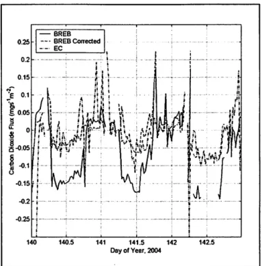
Due to the differences inherent to the Bowen Ratio Energy Balance (BREB) and Eddy Covariance (EC) methods of measuring surface fluxes, each can yield substantially different measures of the same flux. This research sought to quantify the magnitude and scope of these differences by analyzing data collected at the CPER during the spring of 2004. By elucidating the relationships between the various fluxes as measured by the two methods, this research was able to generate techniques that could be used to reconcile the data collected by each of these methods. Specific emphasis was placed on the latent heat flux (AE) and the carbon dioxide flux (Fe) as they demonstrated the greatest differences.
When measured via the BREB method, AE was consistently greater than the same flux measured with the sensor systems associated with the EC method. This difference was as great as 40% during the daytime period. However, using the polynomial relationship developed in this research, it was possible to reduce the differences to less than 10%.
Similarly, Fe measured via the BREB method was 0.04 mg S-lm-2 or nearly 2.5
times greater than the same flux measured via the EC method. Given that measures associated with the EC method were more consistent with other estimates of the carbon budget at the research site, a family of curves were derived to correct Fe
measured via the BREB method to those from the EC method. As can be seen in the figure, the measure of Fe by the
BREB method, when corrected, is quite similar to the measure via the EC method. Again, the agreement is within 10%. This correction, along with the one associated with AE, can be used to generate a consistent long
term data set.
Overall, while many components of the surface energy budget were quite similar regardless of the measurement method employed, both AE and Fe required some correction to yield a consistent long-term data set. The resulting data set, however, could then be used with confidence as the
-BREB -_. BREBCorrected ) ( ::I u: 0 -8 ~-O.05 6 ~ -0.1 _._. EC I i -O.2j"· i i -0.25 .j ... , ... , ... . i ! 140 140.5 141 141.5 i Ij ii Ii! '1 J!i ... p' I! 1\4 ! • I' ,.
..
I"" . . ...
. ~ ~. ...
,1\ ~ , ~I... ' ;
"VtfTJ
.. ~~ . ~ ... ··i···:··· ... i . i . . .••..••.••••. ; ... , .. • .... • .. 7 ... ·· .... · ... . i ! 142 142.5 Day of Year. 2004Figure 1: As evidenced by the typical three day period shown, the correction of Fe measured via the BREB method using the relationships ~eveloped in this research yielded a flux consistent with the measurements obtained with the EC method.
foundation for further research into the linkages between the land surface and the atmosphere over grassland environments.
r
r
r
r
r
r
r
r
r
r
r
r
r
r
r
r
r
r
r
1. Presenting author: Adriana Beltnin-Przekurat 2. Affiliation: Colorado State University
3. Address: Department of Atmospheric Science 1371 Campus Delivery
Colorado State University Fort Collins. CO 80523-1371 4. Phone number: 970.491.8565
5. Email: abeltran @ atmos.colostate.edu
Beltnin-Przekurat1, A, RA Pielke1 Sr., JA Morgan2, D Le Cain2 and D Smith2
1 Atmospheric Science, 2USDA-ARS. Land-atmosphere interactions in semiarid areas: examples
from Shortgrass Steppe and Jornada LTER sites.
Observations and modeling results have shown that land use practices have affected regional climate in the Shortgrass Steppe (SGS) region through their influence on energy partitioning and balance. A coupled atmospheric-vegetation model constitutes an appropriate tool to study the interactions and feedbacks between the vegetation, soil and the atmosphere. The Regional
Atmospheric Modeling System coupled with a plant-scale model GEMRAMS is used to quantify the potential impact of these land use practices on mesoscale climatic patterns at the SGS LTER site. At the Jornada LTER, the conversion from the natural landscape of grasses to the current landscape of shrubs has been shown with the high resolution model version of GEMRAMS to result in significant changes in surface heat and moisture fluxes. The same modeling approach will be used in the SGS LTER site. Measurements of CO2 and water fluxes will be used to validate the performance of the coupled modeling system GEMRAMS.
z o
~
0:: (3 w a: a.. Temperature Relative humidity Radiation (PAR) PH ESIS zl 0 : i=l «: 0:: o::i ~n O:l . ~ :1iLE;j~f.:=~~{"
...
I ...
~~Te~m~~.~~~
....i
:: i :: .. ~_r.;"···""···I··"·"···'···"···· ... 0.:: : ~--~ § ! § §j
.::: .. : ... : ... :.:::: .. :.: ... : ... .J
r
r
r
r
r
r
r
r
r
r
r
r
r
r
r
r
r
r
r
L1. Presenting Author: Steve Blecker
2. Affiliation: Colorado State University
3. Address: Department of Soil and Crop Sciences
4. Phone number: 5. E-mail:
Colorado State University Fort Collins, CO 80523-1170
(970) 491-5573
sblecker@nrel.colostate.edu
S.W. Blecker, S.E. Melzer-Drinnen, C.M. Yonker, and E.F Kelly. (Soil and Crop Sciences, Colorado State University). The role of plants in regulating the biogeochemistry of silica in temperate grassland ecosystems of the mid-continent of North America.
There is a substantial body of evidence that suggests that plants may transform silica into more stable or labile forms, thus acting as potential sources or sinks of silica. Estimates of soil weathering rates need to include the influence of biogenic silica on primary silicate weathering, which in tum influence evaluations of paleoclimate. To further quantify biological cycling of silica, we present the initial results of state factor (bioclimo- and chronosequences), constituent mass balance, and geochemical analyses of soil and biogenic silica to quantify the role of plants in regulating the biogeochemistry of silica in temperate grassland ecosystems of the
mid-continent of North America. Isotopic analyses of soils and biogenic minerals in tropical
ecosystems have shown that
o
30Si values within the soil profiles exhibit a strong differentiation between a more biologically influenced surface layer, and the less biologically active deeper layer. Of the grassland ecosystems we studied, shortgrass steppe ecosystems have the greatest accumulations of biogenic silica in soil and the lowest silica storage in biomass, whereas the tall grass systems have greatest biomass silica and lowest biogenic silica accumulation in soil. Our paper will integrate pedological and geochemical characterization to provide a synthetic treatment of the potential role of grassland ecosystems in the mobilization and storage of silica worldwide.r
r
r
r
r
r
r
r
r
r
r
r
r
lr
r
r
r
r
r
1. Presenting Author: Safi-Kirstine Darden 2. Affiliation: University of Copenhagen 3. Address: Animal Behaviour Group
4. Phone Number:
Department of Population Biology Institute of Biology
University of Copenhagen
Tagensvej 16, DK-2200 Copenhagen N 5. E-mail: S-KDarden@zi.ku.dk
Darden, S. K. & Dabelsteen, T. (Institute of Biology, University of Copenhagen) Mediation of Spatial Organization in the Swift Fox: Preliminary Observations
Animals communicate in a network of individuals (McGregor and Dabelsteen 1996). Acoustic, chemical, and visual signals can operate in this network to convey information about a signaller's identity, behaviour, physiological state and location. The communication of these types of information can function in maintaining social distances, attracting mates, and defending or announcing territories. Signal transmission properties determine signal value at different temporal and geographical distances from the signaller and a signal's transmission distance may influence social spacing and individual movement patterns, which themselves may influence signal modality.
Canid species are often nocturnal, have large home ranges and use auditory and olfactory cues in intra- and inter-social group communication. In grey wolves (Canis lupus), for example, where the social group (pack) is usually comprised of several related and unrelated individuals that collectively defend a territory from neighbouring packs, scent marking and howling function in maintaining inter-pack distances and in defending territory boundaries (Rothman and Mech 1979, Harrington and Mech 1983). These two signalling modalities also function in maintaining contact between group members as they move about the territory (Schassburger 1993). In the large canids, scent-marking and howling seem to be most intense during dispersal and mating when territorial intrusions are most prevalent and contact is important for the coordination of mating (e.g., Wells and Bekoff 1981, Asa and Valdespino 1998, Jaeger et al. 1996). In the small canids, these types of signals are thought to be important in understanding population dynamics and social interactions (e.g., White et al. 2000), but have only been briefly addressed (e.g., Macdonald 1979).
The swift fox (Vulpes velox) is a small, socially monogamous North American canid that has been found to occupy large home ranges that overlap up to 40% with those of neighbouring individuals and up to 100% with pair-mates (Pechacek et al. 2000). The overlapping home ranges create a dynamic spatial context in which long-range and static signals should have important functions in regulating intra-specific spatial separation and mated pair contact. Preliminary results from observations of 19 individuals (10 males and 9 females) monitored during the mating and pup-rearing seasons suggest that acoustic and chemical signals play an important role in information transfer, not only within pairs, but also between neighbours. We have found that long-ranging vocalizations are used frequently during the mating season and may convey individual identity as well as gender information. We have also found that the foxes may be using faecal latrines as information centrals for mates and neighbouring foxes. From information on the potential for both static and instantaneous interactions (degree of home range overlap and animal movement, respectively) we are now planning experiments further investigating aspects of swift fox olfactory and acoustic communication in a network context.
References
Asa and Valdespino (1998). Am. Zool., 38, 251-259.
Harrington and Mach (1983). Behav. Ecol. and Sociobiol., 12, 161-168. Jaeger et aI. (1996). J. Mammal., 77, 768-775.
Macdonald (1979). Z. Tierphsychol., 51, 1-22.
McGregor and Dabelsteen (1996). In: Ecology and Evolution of Acoustic Communication in Birds. 409-425. Pechacek et al. (2000). Z. Saugetierkunde, 65, 209-215.
Rothman and Mech (1979). Animal Behav., 27, 750-760. Schassburger (1993). Adv. Ethol., 30, pp 84.
Wells and Bekoff (1981). In: Acoustic Behaviour of Animals. 751-786. White et al. (2000). J. Mammal., 81, 456-461.
r
r
r
r
r
r
r
r
r
r
r
Lr
r
r
r
r
1. Presenting Author: 2. Affiliation: 3. Address: 4. Phone Number: 5. E-mail: James L. DyeUniversity of Northern Colorado Department of Biological Sciences 501 20th St.
Greeley, CO 80639 970-351-2101
dye5872 @blue.unco.edu
Dye, J.L. and M.R. Banta (Dept. of Biological Sciences, Univ. Northern Colorado). Historical and current trapping records for heteromyid rodents in northern Colorado.
As part of a larger project examining aspects of torpor and winter metabolism in the silky pocket mouse (Perognathus flavus) , we attempted to trap several individuals of P. flavus at various sites on the Central Plains Experimental range (CPER) during summer 2004. Historical trapping records for this area include this species as well as other heteromyid rodents (Perognathus hispidus and Dipodomys ordii). For the same project we also trapped a short-grass region 15 km east of Greeley, CO. This area is on State of Colorado Public Land that is leased to a local rancher and grazed periodically by cattle and horse.
On the LTER we accumulated a total of 1580 trap nights between June-August 2004 spanning seven different sections. This resulted in the capture of eight individuals: 3 Ord's kangaroo rats (D. ordii), 3 deer mice (Peromyscus maniculatus), 1 northern grasshopper mouse (Onychomys leucogaster) and one juvenile cottontail rabbit (Sylvilagus spp.). This represents an overall trapping success rate of 0.5%, with no captures of the target species.
On the east Greeley site we accumulated 1591 trap nights between September-November 2004 all within a single section (Sec6 T5N R63W). This resulted in the capture of 228 individuals: 91 Ord's kangaroo rats (D. ordii), 33 deer mice (P. maniculatus), 33 northern grasshopper mice (0. leucogaster), 19 plains pocket mice (Perognathus flavescens) , and 53 silky pocket mice (P. flavus) which was the target species. This capture represents an overall trapping success rate of
14.3 %, with a 3.3 % capture of the target species.
The east Greeley site appears to have a greater abundance of vegetation for an increase of ground cover and food availability. The sandy soil at the east Greeley site may also prove to be more favorable for burrowing by many individuals. Lastly, with the strain imposed by several years of drought, individuals at the east Greeley site may have been affected less by the drought than individuals on the L TER.
I. Presenting Author: 2. Affiliation: 3. Address: 4. Phone Number: 5. E-mail: Robert Flynn
Colorado State University
Department of Soil and Crop Sciences
Colorado State University Fort Collins, CO 80523-1170 970.491.6832
Robert. Flynn@colostate.edu
Flynn, RL, NE Kaplan (Soil and Crop Sciences). GIS Data and Tools Available at the SGS LTER.
Tools for gather and viewing GIS data in the lield. Handheld PC's now provide a means for gathering
spatial data for LTER experiments. With these devices, field workers can navigate to and record research
site information.
Tools on the SGS website for viewing and obtaining GIS data. The SGS Map Viewing Tool is available on the SGS Website for viewing, printing and capturing images of GIS data. The basic version only requires an internet browser, while the advanced version uses a freely downloadable tool for customized maps.
Tools for Analysis of SGS spatial data GIS data. Analysis and modeling of data using GIS software is
being performed extensively at the SGS L TER. Examples include generation of random sample points, proximity analysis, interpolation of sample data, spatial change over time, spatial correlation of physical factors (soil, water, vegetation, etc), species population and interaction modeling, and climate modeling.
GIS data layers. Various GIS data layers are available to researches at the SGS L TER. These include static physical data (boundaries, elevation, water, pastures, roads, soils, etc.), dynamic data (prairie dog towns, burn areas, exclosures), experiment site data, and multispectral imagery.
Map Viewing Tool on SGS LTER Website f IIw"",tl!" " 'f fi Fif
15:
)
1
¥ C .. .... ~ --~ - ."- ' ... -.~ r ' _ . -...,
- ...--8::: ::.: :--........ ..
r
r
r
L
r
r
L.r
r
r
r
r
r
r
r
r
r
r
r
r
r
L 1. Presenting Author: 2. Affiliation: 3. Address: 4. Phone Number: 5. E-mail: Doug GrantUSDA-ARS, Rangeland Resources Research Unit Crops Research Laboratory
1701 Centre Ave. Fort Collins, CO 80526 (970) 492-7126
doug.grant@ars.usda.gov
. Grant, DWI, SJ Del Grossol,2, WJ Parton2, JD Reederl, JA Morgan I eUSDA, Agricultural Research Service, Ft. Collins, CO, 2Natural Resources Ecology Laboratory (NREL), Colorado State University, Ft. Collins, CO). Drought and grazing interaction and recovery in shortgrass steppe: a DA YCENT modeling analysis.
Global climate change may result in a warmer drier climate with more frequent drought episodes in the Great Plains region of North America. Plant productivity decreases during drought
conditions, reducing OM inputs from grasses and decreasing forage production. We used the DA YCENT biogeochemical model to examine the potential responses of SOM to increased drought frequency and the interaction between drought and rest from cattle grazing. Weather data from 1950 through 2002 at the CPER were categorized as drought or non-drought years based on three criteria: 1) early-season precipitation (April-June), 2) total annual precipitation, and 3) early-season actual evapotranspiration (AET). Using the early season AET or
precipitation criteria, drought occurred in one out of six years (9 of 53 years) when drought was defined as one standard deviation below the mean climatic variable. We selected a subset of the weather data (1955 to 1974) to analyze how SOM dynamics would be affected if drought frequency increased to one out of four years and this weather cycle was repeated to drive 60 years of simulations. Grazing during drought years followed by a year of rest (RA) was compared to rest during the year of drought (RD) and continuous season-long grazing (GR) to look at the interaction between drought and rest from grazing. This analysis revealed that rest during the year of drought (RD) did not significantly enhance C sequestration potential of the soil over continuous grazing (GR), while rest the year after drought (RA) did slightly improve soil C sequestration or at least offset the increase of SOM losses associated with increased drought frequency. This response was largely attributable to the rareness of consecutive drought years and increased potential for C sequestration from rest in non-drought years resulting from increased plant inputs.
2300 soc 2250 ~ ~ 2200 2150 2100 - t - - - , . . - - - , - - - - , - - - , - - - - , - - - , 1960 1970 1980 1990 2000 2010 2020
r
r
r
r
r
r
r
Lr
r
r
r
r
r
r
r
r
r
1. Presenting Author: 2. Affiliation: 3. Address: 4. Phone number: 5. E-mail: Niall HananNatural Resource Ecology Laboratory Natural Resource Ecology Laboratory Colorado State University
Fort Collins, CO 80523-1499 970.491.0240
Niall.Hanan@colostate.edu
Niall Hanan I , Thomas Peterson I , Jack Morgan2, Jean Reeder2, Indy Burke3, and Keith Paustian I eNatural Resource Ecology Laboratory, CSU, 2 Agricultural Research
Service, USDA, 3Department of Forest Sciences, CSU). Land-Use Impacts on Carbon and Water Flux on the Shortgrass Steppe in Eastern Colorado - Preliminary Results The USDA Conservation Reserve Program (CRP) currently has active contracts on more than 2 million acres in the shortgrass steppe region of eastern Colorado alone. As contracts end, or. if the CRP is discontinued, land owners will likely decide on future usage depending on the economic returns available in alternative management, e.g., grazing or dry land agriculture. The management changes will alter vegetation structure and phenology in ways that will impact short- and long-term carbon, water and energy exchange.
We have developed a manipulative experiment on a private ranch 60 km west of Fort Collins to measure the impacts of the land-use alternatives in CRP lands on short-term carbon, water and energy fluxes and long-term carbon and water storage. Three eddy covariance towers have been established in adjacent 40-hectare parcels of CRP land that had been in the program for approximately 17 years. After an initial comparison period to establish the similarity of the three parcels, one was opened to cattle grazing at moderate intensity, while the second was converted to the first stages of a minimum-till, wheat-hay millet rotation. The third parcel remained in CRP as a contro1. Fluxes of carbon, water and energy have been made in the three plots for more than a year, including baseline comparison and post-manipulation periods. Preliminary results show divergence in daily net carbon flux (g C m-2) and evapotranspiration (mm H20) between plots. Considerable divergence of fluxes in the crop treatment was evident. Following removal of CRP vegetation in April-May, the photosynthetic uptake was effectively zero and respiratory losses dominated the CO2 flux. Transpiration was also reduced during the fallow period, representing a net saving of water important for the later germination and growth of the winter wheat crop. Following grass removal, the fallow crop site became a source of carbon dioxide release to the atmosphere. The graze site had greater cumulative uptake of carbon in the spring, perhaps related to reduced, moribund plant material and resulting increased photosynthetic uptake. Following further grazing and leaf-area index (LAI) reductions in mid-May, the graze treatment uptake was reduced to values similar to the control site. Water loss from the un grazed and grazed sites appears similar, but a small amount of water was being conserved in the fallow crop site for the winter wheat seeding in September.
r
r
r
r
r
r
r
Lr
r
Lr
r
r
IF"t
r
r
r
r
r
r
1. Presenting Author: 2. Affiliation: 3. Address: 4. Phone Number: 5. Email: Kelly HardwickeColorado State University Department of Biology Colorado State University Fort Collins, CO, 80523 970-491-2354
khardwic@lamar.colostate.edu
Hardwicke, KB and Detling, JK. (Department of Biology). Species interactions across three trophic levels: Cynomys ludovicianus colonies increase floral visitation by insects.
Black-tailed prairie dogs (Cynomys ludovicianus) change vegetation structure and composition on the mixed grass prairie and shortgrass steppe, with active colonies showing higher herbaceous dicot coverage, reduced canopy height, and an increase in bare ground, allowing for higher germination of flowering annuals. Extensive (> 40 hectares) Cynomys colonies create large patches within the prairie matrix containing a higher density of floral resources, which pollinating insects should react to favorably and may perceive or utilize as a differing habitat type. In the first of three consecutive years of study, four large towns and paired off-town areas on the SGS-LTER in northeastern Colorado were sampled for floral resources. Vegetation
sampling was followed by diurnal insect visitation measurement, which involved hand capture of observed floral foragers, and indication of the floral resources they utilized. In May - July of 2003, approximately twice as many inflorescences and open flowers were found on the towns as off. Concomitantly, over two times as many insect visitors were observed foraging on the towns during the paired sampling periods. Both of the dominant pollinator orders in this system, Hymenoptera and Lepidoptera, were observed foraging 2-3 times more frequently at on-town sites. The Hymenoptera, but not the Lepidoptera, showed differing relative abundances and community structure at the level of family on-town compared to off-town. These data suggest that C. ludovicianus may be an important driver of patch heterogeneity in the plantscape of this system, and affect floral resources that influence pollinator abundance and community structure on the shortgrass steppe.
r
r
r
r
r
r
r
r
r
r
r
r
r
r
r
r
r
r
r
1. Presenting Author: 2. Affiliation: 3. Address: 4. Phone Number: 5. E-mail: J ana L. HeislerColorado State University
Department of Biology (Graduate Degree Program in Ecology) Colorado State University, Fort Collins, CO 80523-1878 970.491.0453
jheisler@lamar.colostate.edu
Heisler, JL, and AK Knapp. (Department of Biology). Ecosystem response to climate change: sensitivity of grassland ecosystems across the Great Plains to variability in precipitation. Projected changes in climate include warming of the atmosphere and increasingly variable precipitation regimes, both of which may affect soil, plant, and ecosystem properties. Water availability is an important determinant of aboveground net primary productivity (ANPP) and increasing evidence suggests that many aspects of ecosystem structure and function are quite sensitive to intra-annual variability in precipitation. ANPP is an integrated assessment of
ecosystem structure and function and thus a valuable means of identifying change in response to resource availability (water). However, responses in ANPP are subject to physiological,
vegetation composition, and biogeochemical constraints that are altered on different time scales. For this reason, this investigation will additionally seek to identify alterations in plant
physiology/phenology, community-level processes, and soil processes - as these system attributes may act independently or interactively to drive variations in ANPP.
The overall objective of this research is to develop a mechanistic understanding between
variation in ANPP and variation in precipitation across sites that span a broad precipitation, soil nutrient and species composition (short to mixed to tall grass) gradient. This research is a multi-site study that includes the Shortgrass Steppe LTER, the Konza Prairie LTER, and the KSU Agricultural Research Center in Hays, Kansas.
Precipitation Variability
Dynamics of Aboveground Net Primary Productivity
I. Presenting Author: 2. Affiliation: 3. Address: 4. Phone number: 5. E-mail: Gene Kelly
Colorado State University
Department of Soil and Crop Sciences Colorado State University
Fort Collins, CO 80523-1170 970.491.6881
pedoiso@lamar.colostate.edu
Kelly, EFI, IC Burke2, MF Antolin3, WK Lauenroth2, JC Moore4, JA Morgan5, JK Delling3, DG
Milchunas2, AR Mosier5, WJ Parton6, KJ-I Paustian6, RA Pielke7, and PA Stapps. (ISoil and Crop Sciences, 2Forest, Rangeland and Watershed Stewardship, 3Biology, 4Biology, U. Northern
Colorado, 5USDA-ARS, 6NREL, 7 Atmospheric Science, 8Biological Science, California State U.
-Fullerton). Shortgrass Steppe Long Term Ecological Research.
The shortgrass steppe (SGS) Long Term Ecological Research (LTER) site is part ofa network of
long-term research sites supported by the National Science Foundation. The network consists of
26 sites representing diverse ecosystems and research emphases, yet maintaining a common mission and sharing expertise and data.
The SGS site, located on the Pawnee National Grasslands, uniquely represents the short grass steppe ecosystem within the network. We assert that the ecological structure and function of the
shortgrass steppe is governed by climate, human use, natural disturbance, biota and
physiography. The representation of our conceptual framework, below, depicts the relationship between these factors and our core research areas: population dynamics, biogeochemical dynamics and land-atmosphere interactions. A summary of key research findings and current
endeavors is presented for each core research area. Brief discussions of synthesis activities,
cross-site projects and educational outreach activities are also presented.
Determinants of SGS Structure and Function:
Research Areas:
Populations and PrOCOIISOS
3,4,5,7,8 land·Atmosphoric Interactions 1,2,3,6,7 BiogeochemIcal DynamIcs 1,6,7,8 Climate
..
~.
.
.
.
.
.
.
~.
. "..
..
I. Presenting Author: 2. Affiliation: 3. Address: 4. Phone number: 5. E-mail: Gene Kelly Colorado State University Department of Soil and Crop Sciences Colorado State University Fort Collins, CO 80523-1170 970.491.6881 pedoiso@lamar.colostate.edu http://www.lternet.edu/ . LTER: Long Term Ecological Research Network.
With an initial six sites selected in 1980, the National Science Foundation established the Long Term Ecological Research Network to study broad spatial and temporal scale environmental
phenomena. Currently, twenty-six sites (including shortgrass steppe, SGS) represent the
Network - a collaborative effort of more than 1800 scientists, students, and educators. Each site
has in common a research program developed around five core research areas:
• Pattern and control of primary production
Spatial and temporal distribution of populations selected to represent trophic structures
• Pattern and control of organic matter accumulation and decomposition in surface layers and sediments
Patterns of inorganic inputs and movements of nutrients through soils, groundwater and
surface waters
I. Presenting author: Dan LeCain
2. Affiliation: USDA-ARS-RRRU
3. Address: Crops Research Lab.; 170 I Center Ave.
Fort Collins, CO 80526
4. Phone number:
5. E-mail:
(970) 492-7123
dan.lecain@ars.usda.gov
LeCain, DR, JA Morgan, and F Migliella. (USDA-ARS). Gradient FACE: a new Free Air CO2
Enrichment (FACE) system on native prairie.
Increasing atmospheric CO2 and projected global climate change is one of the century's most
significant environmental issues. Despite considerable research over the past two decades, many
unanswered questions remain concerning how grassland ecosystems will respond to increasing CO2.
From 1996 to 2001, an Open Top Chamber (OTC), elevated CO2 experiment was conducted at the
Central Plains Experimental Range, Shortgrass Steppe site. Although we learned much about
mechanisms underlying grassland responses to CO2, our ability to extrapolate the results was limited
by changes in microclimate due to the chambers.
Free Air CO2 Enrichment (FACE) technology is a relatively non-intrusive CO2 enrichment
method, and is therefore easier to scale beyond the experimental boundaries compared to conventional
chamber designs. In September, 2004 the ARS Rangelands Resource Unit, in collaboration with the
Institute of Biometeorolgy, Firenze, Italy, began testing an innovative Free Air CO2 Enrichment
system, named "Gradient FACE". The system was installed on a northern mixed-grass prairie at the
USDA-ARS High Plains Grasslands Research Station, near Cheyenne WY. Gradient FACE uses a
20m*8m network of piping, precision valves, and a computerized control unit to create a gradient of
CO2 concentrations, from a target enriched concentration (650 flmol morl) to ambient levels. The
control software uses wind speed, wind direction, and CO2 concentration at the center of the plot, to
control injection of pure CO2 to 22 independently controlled zones.
Gradient FACE has several advantages over conventional "ring" FACE systems; most
importantly, the improvement in statistical power of a gradient of treatment C02 concentrations vs.
static CO2 concentrations in a ring FACE system. The system also imposes a CO2 gradient over a
relatively large plot, with a minimal amount of structural components. Data collected in autumn of
2004 show that the system successfully creates a CO2 gradient, over a wide range of wind speeds (0 to
20 m S·I) and a 3600 range' of wind directions. The system will continue to be tested and "fine tuned"
during winter 2004 and spring 2005, with the intention of installing three Gradient FACE systems in
2005, and beginning the CO2 enrichment experiment in spring 2006.
Spatial Distribution of CO2 over Gradient FACE plot (20m
*
8m) during three days" " " # ,,~
..
~ .* I .~ /I • »..
,.~.
.
~1. Presenting Author: John Moore
2. Affiliation: University of Northern Colorado
3. Address: Mathematics and Science Tcaching Institute
Campus box 123, Ross Hall 2279D
University of Northern Colorado
Greeley, CO 80639·
4. Phone number: 970.35 I .2973
5. E-mail: john.moore@unco.cdu
John Moorel, Lori RcinsYoldl, Rob Wang2. (1 University of Northern Colorado, 2Cenlcr for Programs in Education, Antioch
University, Seallle, W A 98 I 2 I). Environmental Education and Outreach for Secondary Native American Educators and
Students.
The Environmental Education and Outreach for Secondary Native American Educators and Students that took place during the Summer of2004 was ajoint effort between the University of Northern Colorado's Mathematics and Science Teaching (MAST) Institute and Rough Rock Community School (RRCS). RRCS is located in the within the Navajo Nation in Northeast Arizona.
The school is operated under Public Law 638, the Indian Self-determination and Assistance Act. Even though this project was limited to RRCS. it is intended Lo serve as a model for the development of programs and partnerships with other tribal nations.
High school graduarion rates for Native American students are among thc lowest of any group in the United States. In
addition, even though science is a required area of study few Native American students pursue a career in the sciences. As
with other Native American schools, the current resources of RRCS to offer a quality science curriculum are extremely limited.
To impact student achievement and motivation to learn science, this project
specifically focused on the design and delivery of a dynamic, culturally
relevant, experiential field-based science experience for RRCS students.
Nine high school students and three RRCS faculty members participated in
this week-long progrnm.
This program integrated ficld-based science, leadership and group
development training, and technology (e.g., GPS, hand-held computers, etc.) into a week-long early college program for RRCS students. Teachers
were introduced to strategies to integrate field-based science research into their classroom activities.
To determine the success of the week long program, the studcnls were given a short qualit~lIive survey to complete at the end of their week experience. Out of a rating system of I - Low, and 10 - high, students ranked the benefit of the week long activities with a 9.5. Specifically they thought highly of using technology to investigate the field based science
topics and the group developmcnt training.
Another indicator of success that is used to determine the success of the experiencc is that studcnts will be motivated to take additional science courses at the high school. Specifically Agriculture Science and Environmental Science courses will be
offered and students will enroll in these Fall 2004 courses. Currently 3 of the 9 summer participating students are enrolled in
AgriculLure Science, and 5 of the 9 are enrolled in Environmental Science. The ninth student has moved to another high
school. Students from the summer program are taking on leadership positions in both classes and applying knowledge gained
in map and compass use and thc use of GPS.
A lasting educational affect of this program is for participating teachers (Q integrate the summer program's activities, strategies
and content into the classroom. Currently a 2 km plot has been organized by one of the participating teachers near their school where students of the Envirollmental Science course are studying erosion and soil deposition. In the Agriculture Science course, another participating teacher is illtroducing the students to plant growth cycles and the nutrient cycles.
Thc Summer 2004 Environmcntal Education and Outreach for Secondary Native American Educators and Students has positively impacted the student's intereslto continue to learn more about the field of science. It has also given Rough Rock
Community School educators tools to expand the ficld based science research activities of their course offerings. The
successful program will now serve as a model for LTER Environmental Education Summer 2005 program at the Short Grass
Steppe. This program will expand and involve the Navajo. Northern Cheyenne, and Lakota Native American educators and
r
r
r
r
r
r
r
r
r
r
r
r
r
r
r
r
r
r
1. Presenting Author: Seth Munson
2. Affiliation: Colorado State University
3. Address: Forest, Rangeland and Watershed Stewardship Colorado State University
Fort Collins, CO 80523-1472 4. Phone number:
5. E-mail: smunson @cnr.colostate.edu
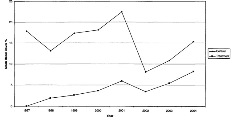
Munson, S.M. and W.K. Lauenroth. (Forest, Rangeland, and Watershed Stewardship). Long-term response of shortgrass steppe vegetation to removal of Bouteloua gracilis.
The aim of this project is to assess the long-term response of vegetation to the removal of the dominant shortgrass steppe species, Bouteloua gracilis. Since complete removal of Bouteloua gracilis from 1 m2 plots in 1997, plant density and cover by species have been monitored annually. Treatment and control plots are located inside and outside grazing exclosure sites to address grazing impact. Removal of Bouteloua gracilis affected vegetation dynamics, with slightly higher species richness in treatment plots. Perennial forb and subshrub density peaked 2-4 years after removal and then declined. Density of annuals was initially higher in treatment plots, but over time showed no difference from control plots. Some subdominant grasses initially increased in relative abundance in treatment plots, while Bouteloua gracilis averaged a 1.4% increase in basal cover per year following removal.
25~---~ ro~---~~---+---~ ~ 15~---~---~~---r---r~~ ~ S i .!
i
10~---~----~~---~ ~ 5+---~~---~~---_=~---~ O~--~----~---~---~---~---____
~---~---~~---~ 1997 1998 1999 2000 2001 2002 2003 2004 YearFigure 1. Bouteloua gracilis mean basal cover in control and treatment plots in six pastures
r
r
r
r
r
r
r
r
r
r
r
r
r
r
r
r
r
r
r
1.· Presenting Author: 2. Affiliation: 3. Address: 4. Phone number: 5. Email:Meghan H. Quirk & Laurel Hartley
University of Northern Colorado & Colorado State University 501 20th St. Greeley CO 80639
970381-4244
buck8007 @unco.edu
John C. Moore I , Meghan H. Quirkl, Howard Horton I, Rod Simpsoni, David Swift2, Laurel Hartley2, Carol Seemueller3.(IMath and Science Teaching (MAST) Institute, and Department of Biological Science, University of Northern Colorado, Greeley 80639,
2Natural Resource Ecology Lab Colorado State University, Fort Collins, 3Rocky Mountain High School, Fort Collins). Colorado Front Range GK-I2 Connecting kids and ecology-teachers and researchers
The mission of the Colorado GK-t 2 grant project is to bring university- based research into the classroom. Within this mission fellows and teachers work closely together to introduce students to scientific concepts that would not typically be introduced into K-I2 classrooms. The theme revolves around "Human impacts on ecosystems along the Front Range."
Fellows help teachers to plan/design research projects that allow students to collect data in a real field setting. Students learn the importance of research protocols and planning, experience the realities of data collection, and analyze data to complete the experience.
r
r
r
r
r
r
r
r
r
r
r
r
r
r
I.r
r
r
r
r
1. Presenting Author: 2. Affiliation: 3. Address: 4. Phone number: 5. E-mail: Renee RondeauColorado State University
Colorado Natural Heritage Program Campus Mail 8002
Colorado State University Fort Collins, CO 80523-8002
970.491.3774
Renee.Rondeau @colostate.edu
Rondeau, R. (Colorado State University). Longevity of Cow Fecal Pats.
In 1998 I established a post-grazing vegetation monitoring study at Pueblo Chemical Depot on the eastern plains of Colorado where the mean annual precipitation is 12 inches. I randomly chose 20 permanent vegetation plots that had been grazed up until the spring of 1998, when all cattle were removed. Within each plot, I randomly selected 8 permanent microplot photo points. From 1998-2003 I conducted repeat photography and recorded any changes from the preceding year. Out of 160 microplots, 15 cow fecal pats in 13 microplots were recorded in 1998. Each photographed cow fecal pat was given a relative score based on size: large, medium, small, and crumbs. Changes were tracked over six years (1998-2003). Of the 15 cow fecal pats noted in 1998, 40% were still present in 2003 (at least 6 years old). All large cow fecal pats in 1998 were still easily recognized in 2003, whereas only 250/0 of the small-class cow fecal pats were
discernable. These small-scale disturbances destroyed the underlying vegetation until the cow fecal pat disintegrated. This information demonstrates a slow decomposition rate for already decomposed vegetation matter in this arid environment.
I. Presenting Author: 2. Affiliation: 3. Address: 4. Phone Number: 5. E-mail: Jennifer Sherry
City of Boulder, Open Space and Mountain Parks Department 66 South Cherryvale Road
Boulder, CO 80303
720.564.2000
sherryj@ci.boulder.co.us
Sherry, J; Riedel, L.; D' Amico, D.; Armstrong, A.; Pelster, A. Bowes, M.; Gershman, M.; Swanson, H. (City of Boulder, Open Space and Mountain Parks Department). Mapping Grassland Vegetation in the UrbanlWidland
III tel/ace: Ecological Information for Integrating Management Goals
Background
The City of Boulder Open Space and Mountain Parks Department (OSMP) manages over 17,500 ha (42,000 acres) of
lands in a rapidly developing urban corridor at the juncture of the Great Plains and Southern Rocky Mountains. About half of the OSMP properties are grasslands. OSMP lands were set aside as buffers against development and to provide
Boulder with the services of ecological conservation, agriculture preservation, and outdoor recreation. To provide
these services sustainably and into the future, Open Space and Mountain Parks is in the process of completing a
comprehensive vegetation map which will be used to aid planners and managers in understanding key attributes of ecological systems.
Product and Methods
This project will provide a map of vegetation at the Alliance level consistent with the United States National
Vegetation Classification System (USNVC) (Grossman et al. 1998). For several years, beginning in the mid 1990' s
OSMP had been using a combination of GIS, aerial photography interpretation and Field work to develop a vegetation map, but lacked a consistent methodology to organize and interpret this information. In 2002, the existing elemell1S of
the project were converted to the USNVC system. Over the past two years, additional field work, using USNVC-based
methods has filled priority gaps. Additional data analysis and interpretation will allow for the production of the first map product in the spring of 2005. Quality assurance and control will begin during the 2005 growing season. We
modified the data collection methods and adapted the classification system to address local ecological conditions as
well as information and management needs.
Management Implications
OSMP grasslands are the Focus of diverse use in an intensely developed landscape. The project will provide information important for integrating the
management of grasslands across diverse interests-specifically: range management, recreation, and ecological conservation. The availability of
vegetation dma will permit us to better understand the dynamic relationships
among grassland vegetation types (see figure) and identify rare elements of the landscape. This information will be used for a variety of planning projects,
including the construction of ecological models and the development of
conservation goals. Vegetation mapping will also be used with other GIS databases to improve our understanding of the legacies of past land use (e.g.
grazing and sand/gravel mining) as well as the affects of current uses of and around OSMP (e.g. urbanization and recreation). Understanding our
conservation goals, as well as the nature of current threats and historical
N
A
__ -===:-_-===F~1
o 1.000 2,000 3,000 4,000
impacts will help us develop restoration and conservation strategies. Agriculture and recreation managers will have a
stronger basis to design livestock grazing practices or visitor facilities that are compatible with grassland conservation. Reference Cited
Grossman D.I-I., Faber-Langendoen D., Weakley A.S., Anderson M., Bourgeron P., Crawford R., Goodin K., Landaal S., Metzler
K., Patlcrson K.D., Pync M., Reid M., and Sneddon L 1998. Imcrnational classification of ecological communities: terrestrial
vegetation of the United Slates. Volume I, The National Vegetation Classification System: development, status, and applications.